
nWo
BGP Meteorologist
-
Joined
-
Last visited
Everything posted by nWo
-
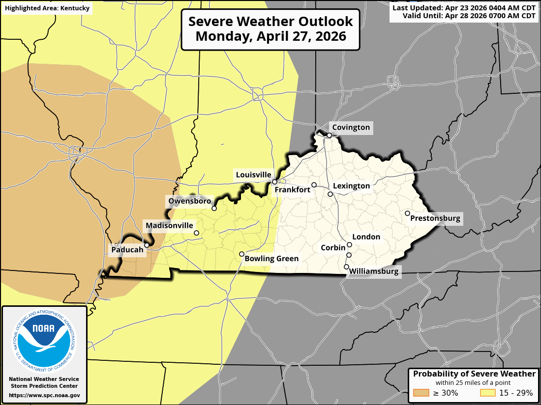
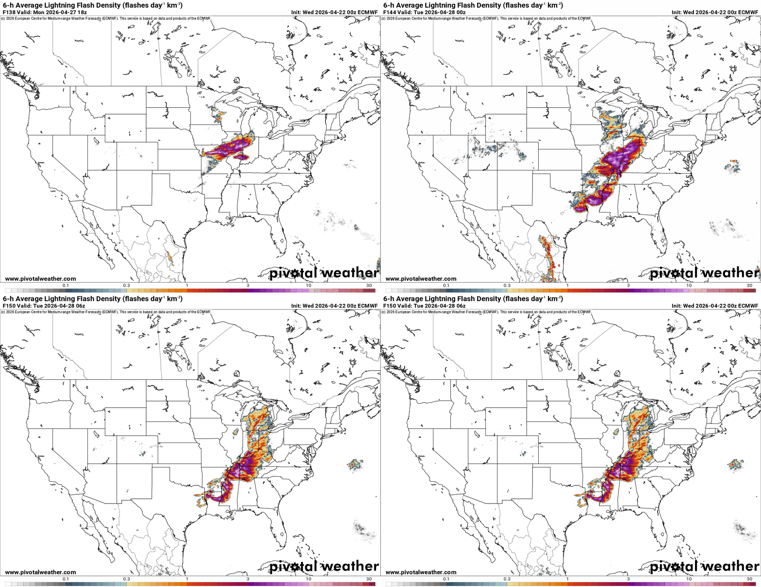
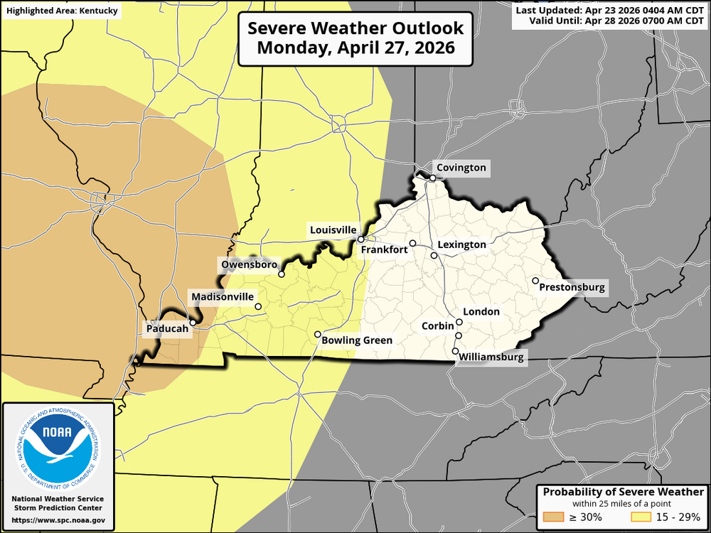
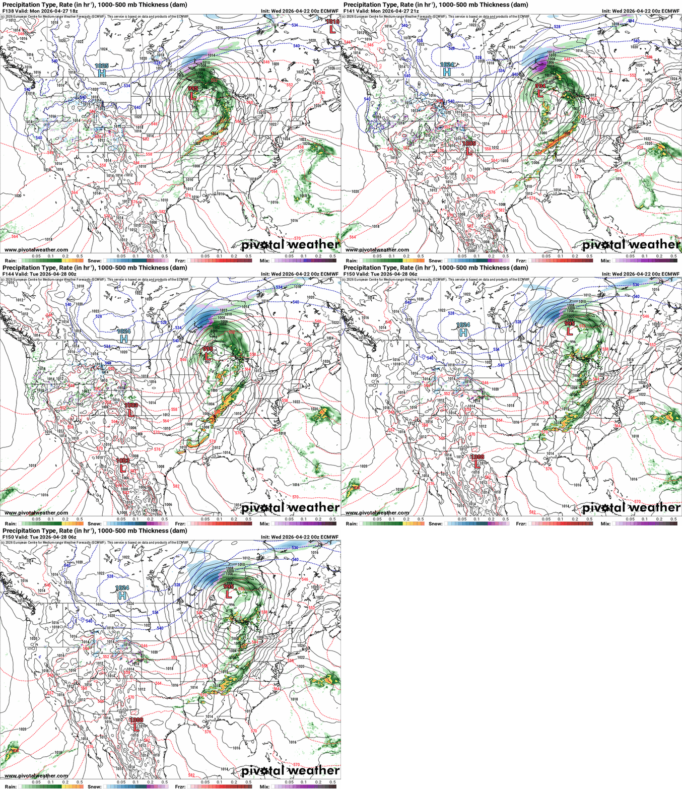
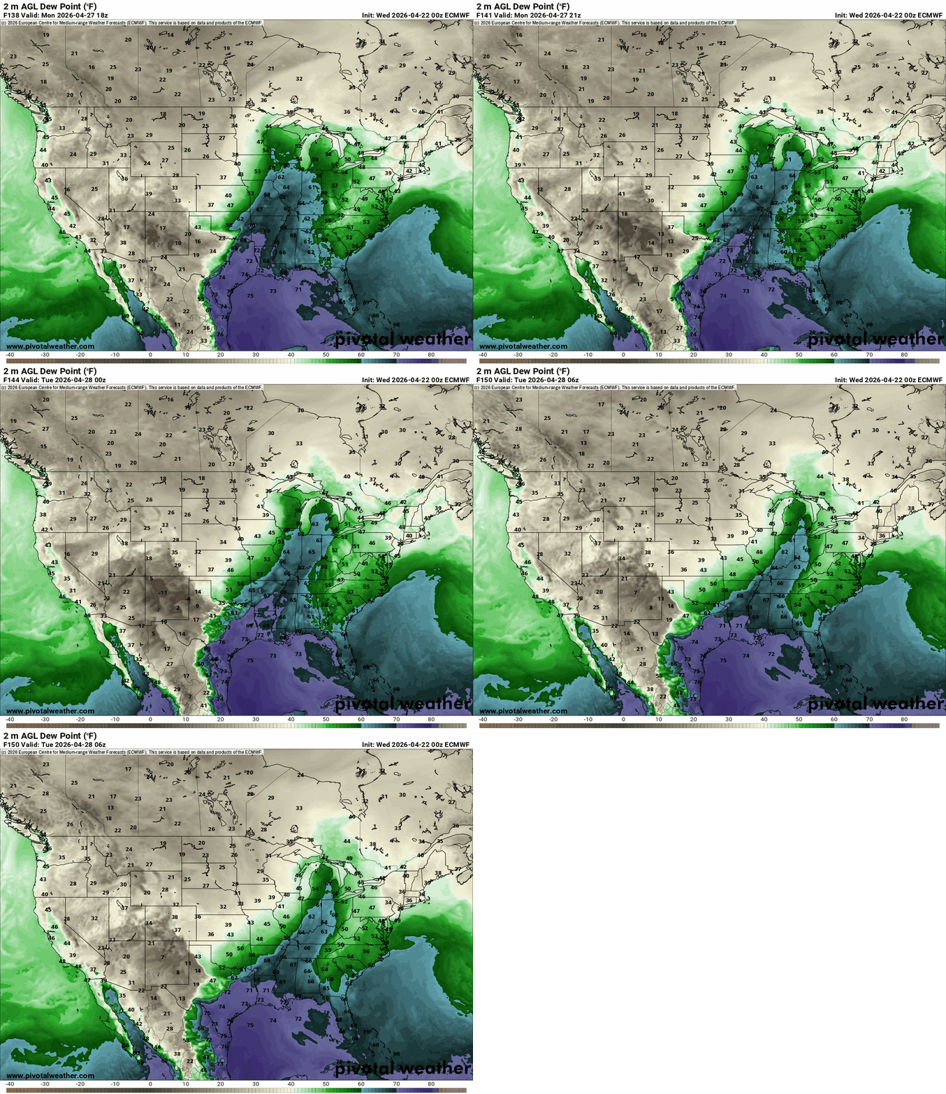
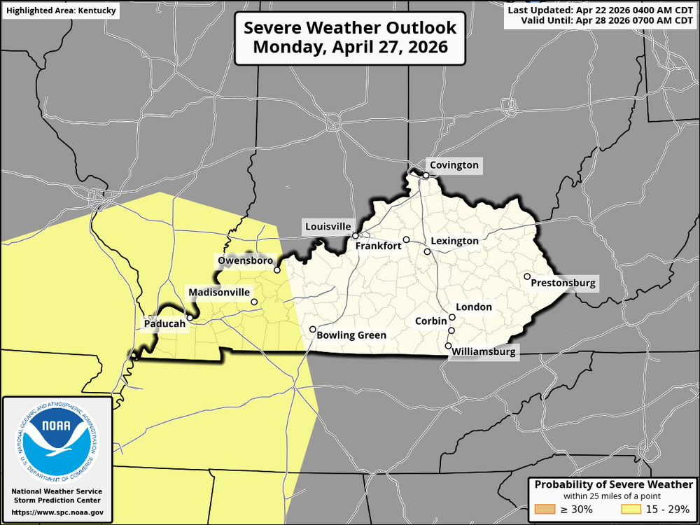
A potent storm system brings a threat of strong to severe storms Monday (4/27). The most likely time for severe weather is Monday afternoon and evening. Timing will likely change as the forecast evolves. The western half of Kentucky and most of southern Indiana are currently under the greatest risk. Severe weather could still be possible outside of the highlighted area. All severe threats are possible: damaging winds, large hail, and tornadoes.
-
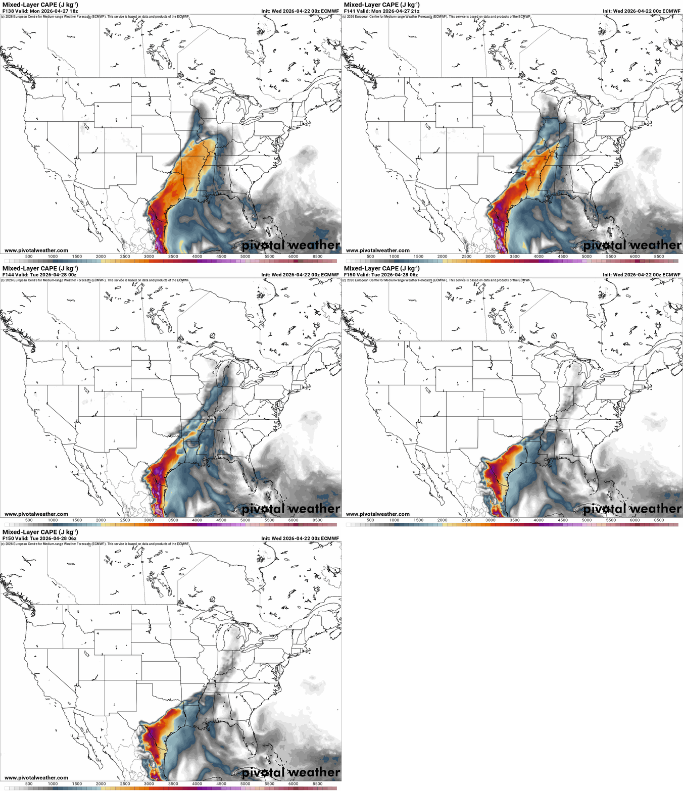
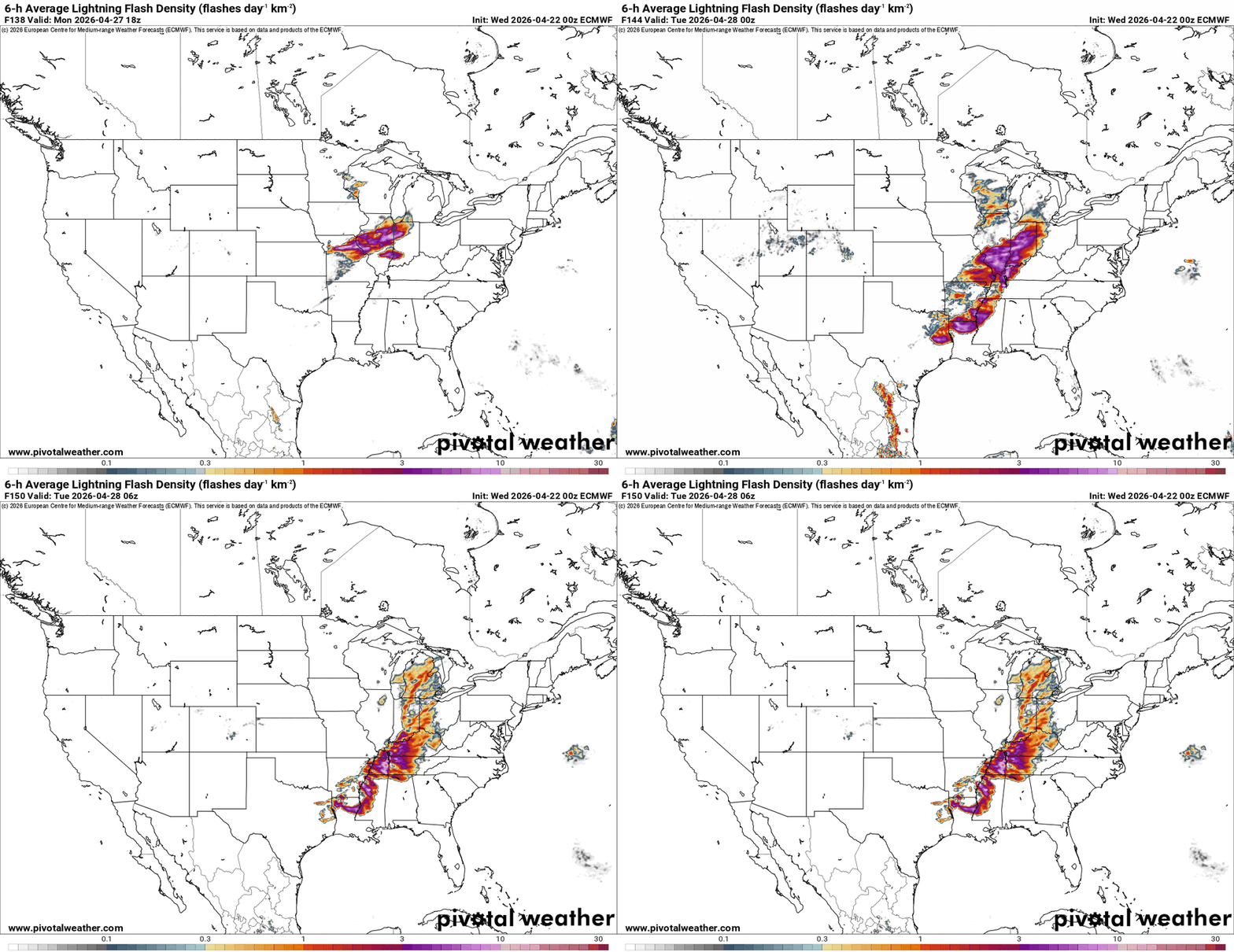
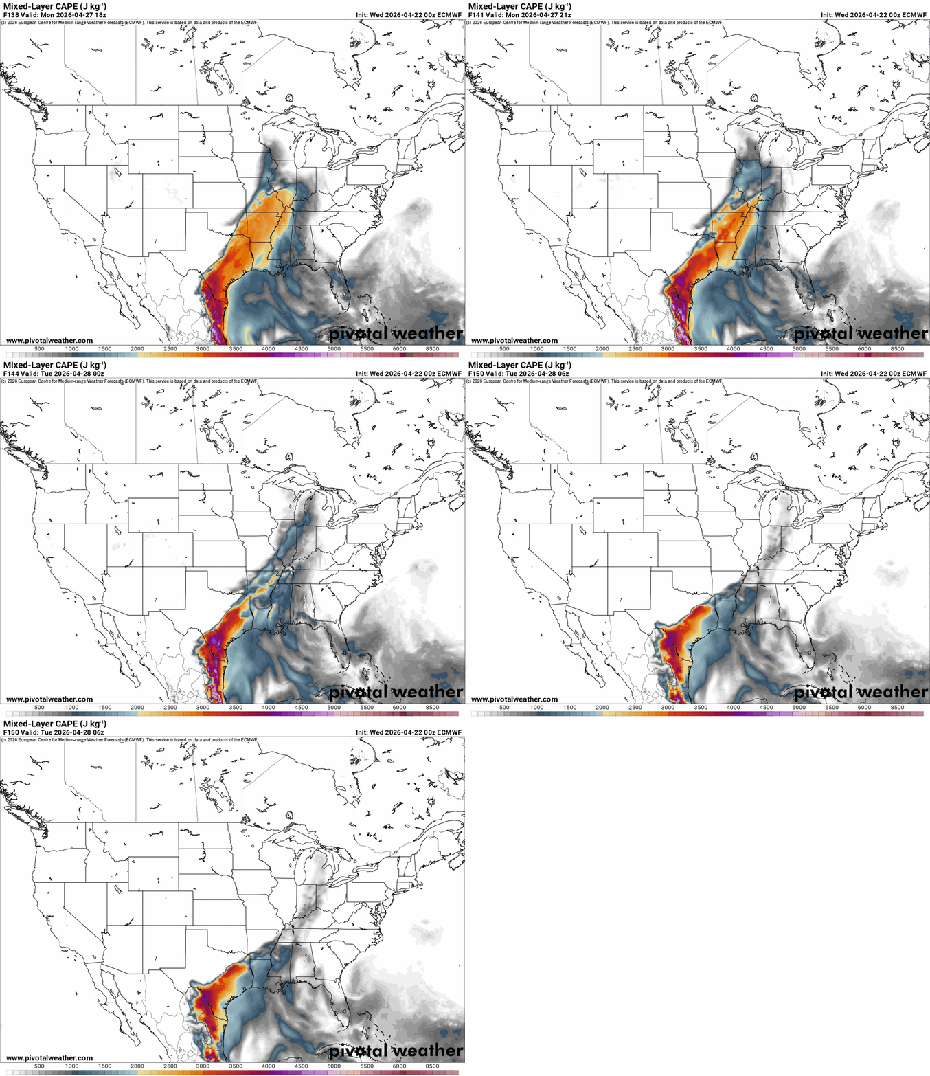
In some areas of the Lower Mississippi Valley, the severe weather threat is predicted to persist through Monday. Strong storms are likely to form ahead of and alongside an eastward-moving cold front. Supercell thunderstorms capable of producing all types of severe weather will be supported by conditions with MUCAPE values between 2000 and 3000 J/kg and 40 knots of deep-layer shear. The weather on Sunday will have an impact on the exact location, quantity, and strength of these storms. More favorable conditions such as higher CAPE and steeper lapse rates may be present for thunderstorms in the Lower Mississippi Valley on Monday if widespread convection does not form across the Southern Plains on Sunday. This could result in a more severe weather threat. The Storm Prediction Center has already issued a 15% chance for western Kentucky in their 6-day outlook. I will keep a close eye on this situation.
-
Here's a 6- to 10-day outlook for Kentucky based on the ensemble forecast data: Above-normal temperatures are expected in Kentucky, which is consistent with the pattern across much of the eastern United States. As weak ridging is predicted over the region, temperatures in the area are likely to be higher than average. While Kentucky may not experience the extreme temperatures of the southern regions, expect a milder trend than typical seasonal norms. Above-average precipitation is expected in Kentucky, particularly as the northern extension of the trough moves eastward. As the trough moves, moisture will enter the area, increasing the chances of rain. Above-normal precipitation is more likely in parts of the Lower Mississippi Valley, which could affect Kentucky, but overall precipitation anomalies are expected to be minor. During this period, Kentucky can expect slightly more rain than usual, with temperatures remaining above average. Keep an eye out for rain showers as the pattern shifts eastward. The region may experience some cloudy days with moderate to light rainfall, but widespread severe weather is not expected.
-
We have switched from La Niña to ENSO neutral this month. In Kentucky, tornado activity can vary significantly depending on the phase of the El Niño-Southern Oscillation (ENSO), which includes La Niña, El Niño, and Neutral years. The tornado frequency in Kentucky during these phases generally follows a predictable pattern. During La Niña years, Kentucky typically experiences 25-35 tornadoes on average. La Niña tends to bring warmer and drier conditions to the Southeast and Midwest, including Kentucky. Tornado activity is generally above average compared to Neutral or El Niño years because the jet stream shifts, causing more storm systems to move across the region, increasing the likelihood of severe weather. Stronger spring storm systems can result in more tornadoes. In El Niño years, Kentucky sees fewer tornadoes, typically around 15-25 per year. El Niño usually brings wetter and cooler conditions to the southeastern U.S., and the jet stream shifts further north, limiting the number of severe storms that move through the state. This results in fewer tornadoes, particularly in the spring months when tornado activity is most common. In neutral years (ENSO neutral), Kentucky averages 20-30 tornadoes annually. Weather patterns in neutral years aren't strongly influenced by either La Niña or El Niño, leading to more typical conditions. Tornado frequency is generally consistent with long-term averages, though it can still vary from year to year.
-
Some of the factors are whether it's an El Niño, La Niña, or ENSO neutral year. I got this data from the NWS and NOAA. States with the Highest Average Annual Tornadoes Texas – ~155 tornadoes per year Kansas – ~96 tornadoes per year Oklahoma – ~62 tornadoes per year Nebraska – ~56 tornadoes per year Missouri – ~45 tornadoes per year States with Moderate Tornado Frequency Illinois – ~38 tornadoes per year Alabama – ~34 tornadoes per year Arkansas – ~33 tornadoes per year Mississippi – ~30 tornadoes per year Tennessee – ~27 tornadoes per year States with Lower Tornado Frequency Kentucky – ~25 tornadoes per year Indiana – ~25 tornadoes per year Ohio – ~20 tornadoes per year Georgia – ~18 tornadoes per year South Carolina – ~15 tornadoes per year States with Very Few Tornadoes California – ~6 tornadoes per year Alaska – ~0 tornadoes per year (extremely rare) Hawaii – Tornadoes are practically non-existent.
-
A Super El Niño is an exceptionally strong, rare, and warm phase of the Pacific Ocean's climate cycle, defined by sea surface temperatures at least +2°C above average in the eastern/central tropical Pacific. It brings extreme global impacts, such as intense droughts, significant flooding, and accelerated global heating, often surpassing the impacts of normal El Niños. Some models are showing that this El Niño could be +3° above average. The latest super El Niño for Kentucky was 2015. A summary of that year will be posted at the end. Here's what this could mean for Kentucky. We know things can change, but this is what it looks like now. For Kentucky, the spring of 2026 is expected to be marked by more typical weather patterns as the state transitions from La Niña to ENSO-neutral conditions. This shift generally leads to moderate temperatures and variable precipitation. Spring could bring a mix of cooler and warmer days, with rainfall amounts closer to normal. However, some lingering effects of La Niña might cause occasional colder spells or drier periods early in the season, particularly in April. As the season progresses into May, the weather should become more stable, with moderate temperatures and a more consistent precipitation pattern, typical of Kentucky’s spring season. Looking further ahead, the summer of 2026 is likely to bring warmer-than-usual temperatures, with an increased chance of heatwaves as El Niño takes hold. This is expected to be accompanied by above-average rainfall, potentially leading to more thunderstorms throughout the summer months. The fall will also be influenced by El Niño, resulting in milder temperatures and increased rainfall, with a wetter-than-usual autumn. Finally, the winter of 2026-2027 is likely to be milder than normal, with reduced snowfall and above-average temperatures, although winter storms in the form of rain or ice could still occur during transitional periods. In summary, Kentucky’s spring of 2026 will likely feature moderate, variable weather, followed by a hotter and wetter summer, a mild and wet fall, and a mild winter with less snow. 2015 Summary 2015 in Kentucky was a year of extreme weather, characterized by a brutally cold, snowy start and a very wet summer, resulting in a slightly warmer than normal year overall. Major highlights included record-setting, snow-packed winters in February/March and one of the wettest summers on record, notably for Louisville and Frankfort. Seasonal Weather Highlights Winter 2014-2015: Extremely cold with high snowfall, especially in eastern Kentucky, which saw 12+ inches and temperatures plunging in some areas in February and March. Spring 2015: Included a significant early April flood (April 2-3) with over 200 water rescues and intense rainfall. Summer 2015: Very wet and stormy; July was the wettest on record for the state, with intense rain in mid-July triggering floods. Fall/Early Winter: Unusually warm and wet, finishing with a mild December. Significant Weather Events Feb 16-17 & March 3-5: Intense winter storms brought 1-2 feet of snow to parts of Kentucky. March 6, 2015: A new state record low for March was set in Hillsboro. July 13-16, 2015: Widespread wind damage and deadly flash flooding occurred in eastern Kentucky. Tornadoes: Several EF-0 and EF-1 tornadoes were reported throughout the year, including April and July events. Temperature/Precipitation Summary Temperatures: Despite the cold start, the year ended with temperatures, on average, warmer than normal, with a very warm late year. Rainfall: Most of the state was wet, with some areas experiencing top-five wettest summers.
-
Kentucky and Cincinnati are predicted to see above-average temperatures during this time, according to the information provided by the weather model. Conditions will be warmer than normal due to the strengthening ridge over a large portion of the central and eastern United States. Over 80% of models are confident that temperatures in the Ohio Valley, which includes Kentucky, will be significantly higher than usual for the season. In terms of precipitation, the strengthening ridge and surface high-pressure systems will reduce rainfall across parts of the Southeast and Middle Atlantic, potentially affecting Kentucky and Cincinnati. During this time, the region is expected to be drier than usual, with below-average precipitation. While the ridge favors drier weather, some isolated rain showers may occur, but the overall trend will be for dry weather. In summary, Kentucky and Cincinnati are forecasted to experience warmer-than-average temperatures and drier-than-average conditions for the 6-10 day period. There is high confidence in this outlook with strong model agreement on the ridging pattern and its impacts on both temperature and precipitation.
-
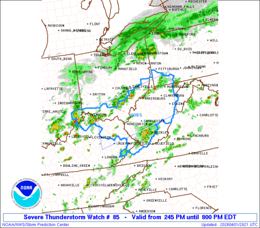
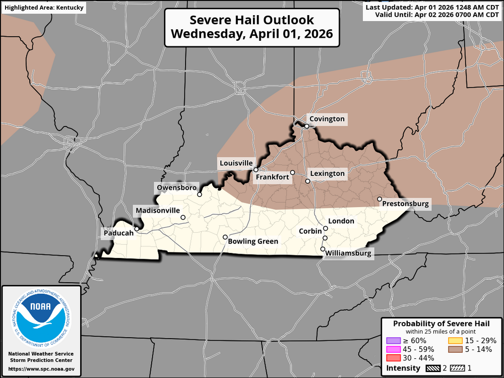
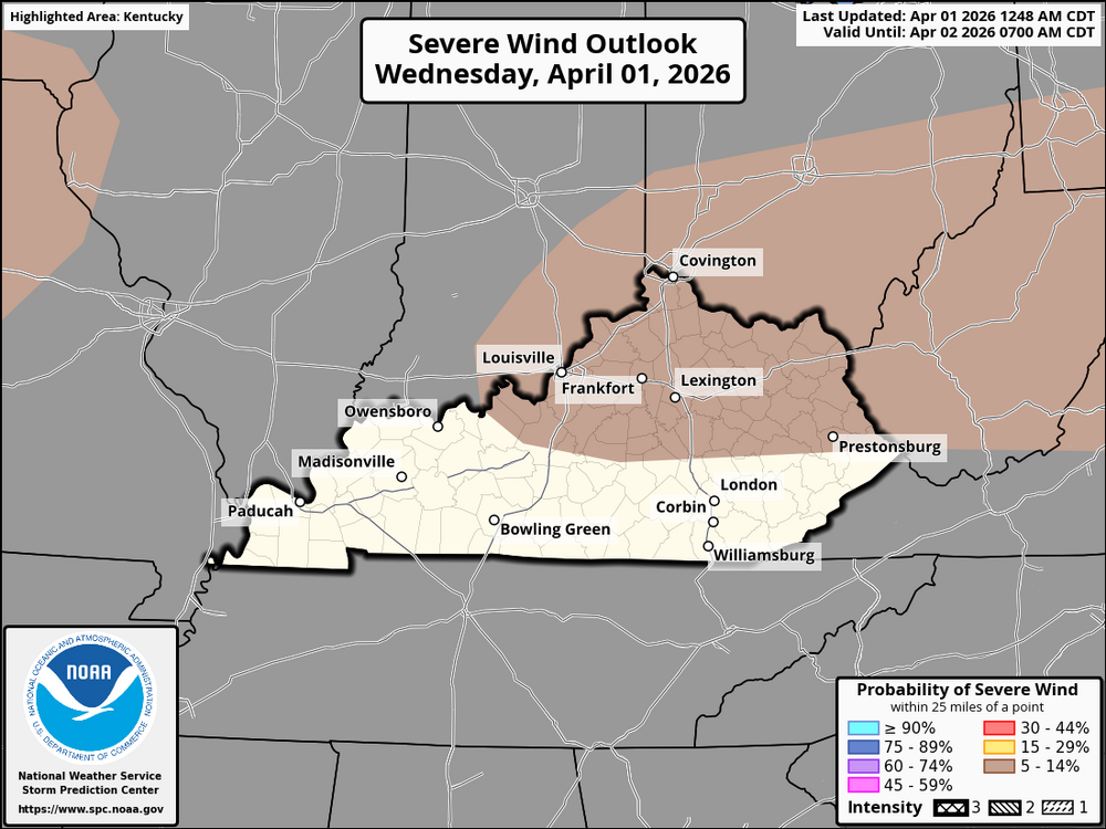
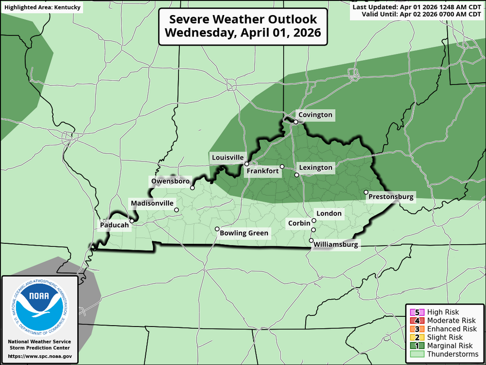
URGENT - IMMEDIATE BROADCAST REQUESTED Severe Thunderstorm Watch Number 85 NWS Storm Prediction Center Norman OK 245 PM EDT Wed Apr 1 2026 The NWS Storm Prediction Center has issued a * Severe Thunderstorm Watch for portions of Southeast Indiana Northeast Kentucky Southern Ohio Southwest Pennsylvania Extreme Southwest Virginia Much of West Virginia * Effective this Wednesday afternoon and evening from 245 PM until 800 PM EDT. * Primary threats include... Scattered damaging wind gusts to 65 mph possible Isolated large hail events to 1.5 inches in diameter possible SUMMARY...Scattered thunderstorms will affect the watch area through the afternoon, in a warm and unstable environment. A few of the storms will pose a risk of damaging wind gusts and hail. The severe thunderstorm watch area is approximately along and 65 statute miles north and south of a line from 80 miles west of Huntington WV to 30 miles southeast of Morgantown WV. For a complete depiction of the watch see the associated watch outline update (WOUS64 KWNS WOU5). PRECAUTIONARY/PREPAREDNESS ACTIONS... REMEMBER...A Severe Thunderstorm Watch means conditions are favorable for severe thunderstorms in and close to the watch area. Persons in these areas should be on the lookout for threatening weather conditions and listen for later statements and possible warnings. Severe thunderstorms can and occasionally do produce tornadoes.
-
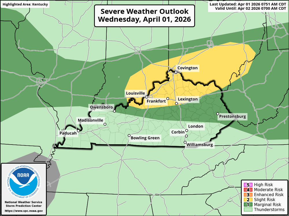
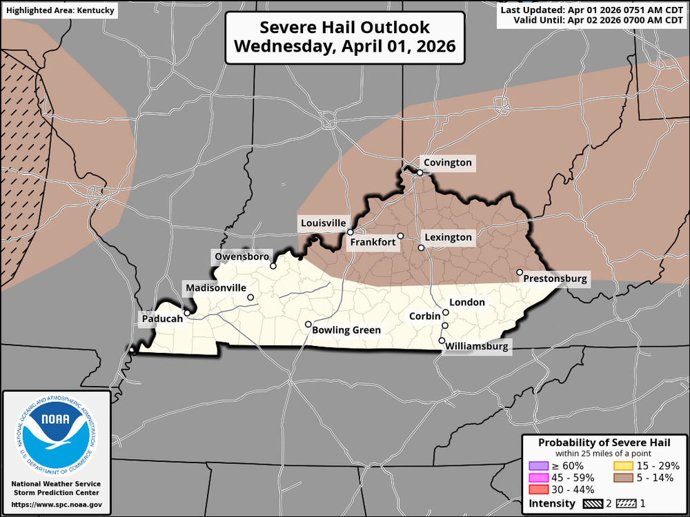
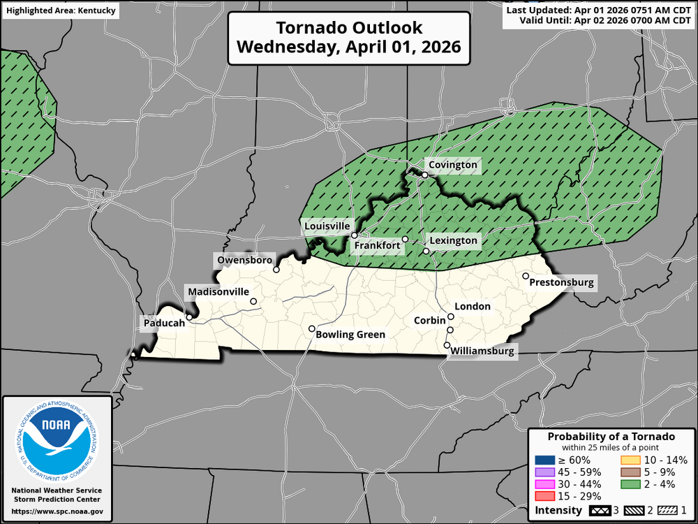
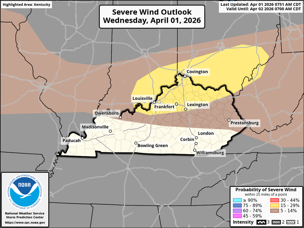
A Bluegrasspreps Severe Weather Alert Day is in effect. A line of thunderstorms is moving through central Missouri and is expected to advance eastward today. As it approaches Kentucky and Cincinnati, the destabilizing air mass ahead of the cold front will create favorable conditions for severe thunderstorms, particularly in the Ohio Valley. The storms are likely to intensify due to the moderate westerly flow aloft. In Kentucky and Cincinnati, thunderstorms will increase in coverage and intensity by the afternoon. The primary severe weather risks will include damaging winds, heavy rainfall, and the potential for large hail. Vertical wind shear will support the development of bowing line segments, which are capable of producing gusty winds. The greatest risk of severe weather will likely occur in the middle Ohio Valley, including the Cincinnati area, where conditions are most favorable for storm development. Stay alert for rapidly changing conditions, especially as storms approach later in the day.
-
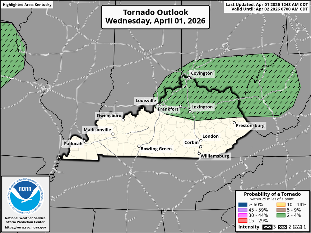
A quasi-stationary front will stretch from southern Indiana to far southern Pennsylvania, and dewpoints in the upper 50s and lower 60s Fahrenheit south of the front will contribute to weak instability by early afternoon. As surface temperatures warm and low-level convergence increases near the front, scattered thunderstorms are expected to develop in short line segments during the afternoon and move eastward across the Ohio Valley into the central Appalachians. With 0-6 km shear in the 25 to 35-knot range and steep low-level lapse rates, isolated severe storms are possible, with the potential for damaging wind gusts and a low-end tornado threat.
-
Kentucky is likely to experience near-to-above-normal temperatures over the next 6-10 days, which is consistent with the predicted positive 500-hPa height anomalies across the eastern United States. The state is expected to be part of a larger above-normal temperature region that includes much of the contiguous United States. (CONUS). The forecast predicts near- to below-normal precipitation across much of the western continental United States, including Kentucky. Given the predicted positive 500-hPa height anomalies across the region, Kentucky is likely to experience drier-than-average conditions or lower-than-normal precipitation during this period. In summary, expect warmer and drier than usual weather in Kentucky over the next 6-10 days, with a general trend of higher temperatures and reduced rainfall.
-
This has been changed to a freeze warning.
-
URGENT - WEATHER MESSAGE National Weather Service Jackson KY 305 AM EDT Fri Mar 27 2026 KYZ084>088-118-120-271615- /O.NEW.KJKL.FZ.W.0001.260328T0400Z-260328T1400Z/ McCreary-Whitley-Knox-Bell-Harlan-Letcher-Pike- Including the cities of Pineville, Jenkins, South Williamson, Middlesboro, Whitesburg, Stearns, Harlan, Elkhorn City, Cumberland, Whitley City, Pikeville, Coal Run, Corbin, Williamsburg, and Barbourville 305 AM EDT Fri Mar 27 2026 ...FREEZE WARNING IN EFFECT FROM MIDNIGHT TONIGHT TO 10 AM EDT SATURDAY... * WHAT...Sub-freezing temperatures as low as 28 degrees expected. * WHERE...McCreary, Whitley, Bell, Harlan, Knox, Letcher, and Pike Counties. * WHEN...From midnight tonight to 10 AM EDT Saturday. * IMPACTS...Frost and freeze conditions could kill crops, other sensitive vegetation and possibly damage unprotected outdoor plumbing. PRECAUTIONARY/PREPAREDNESS ACTIONS... Take steps now to protect tender plants from the cold.
-
URGENT - WEATHER MESSAGE National Weather Service Jackson KY 305 AM EDT Fri Mar 27 2026 KYZ044-050>052-058>060-068-069-079-080-083-104-106>117-119-271615- /O.UPG.KJKL.FZ.A.0001.260328T0400Z-260328T1400Z/ /O.NEW.KJKL.FZ.W.0001.260328T0400Z-260328T1400Z/ Fleming-Montgomery-Bath-Rowan-Estill-Powell-Menifee-Rockcastle- Jackson-Pulaski-Laurel-Wayne-Elliott-Morgan-Johnson-Wolfe- Magoffin-Floyd-Lee-Breathitt-Knott-Owsley-Perry-Clay-Leslie- Martin- Including the cities of Flemingsburg, Hazard, Sandy Hook, Clay City, Pippa Passes, Campton, Wheelwright, McKee, Inez, Morehead, Stanton, Burnside, Salyersville, Paintsville, West Liberty, Ravenna, Irvine, Jackson, Camargo, London, Monticello, Annville, Hindman, Mount Vernon, Somerset, Manchester, Hyden, Prestonsburg, Owingsville, Mount Sterling, Jeffersonville, Frenchburg, Beattyville, Brodhead, and Booneville 305 AM EDT Fri Mar 27 2026 ...FREEZE WARNING IN EFFECT FROM MIDNIGHT TONIGHT TO 10 AM EDT SATURDAY... * WHAT...Sub-freezing temperatures as low as 28 degrees expected. * WHERE...Portions of east central, northeast, south central, and southeast Kentucky. * WHEN...From midnight tonight to 10 AM EDT Saturday. * IMPACTS...Frost and freeze conditions could kill crops, other sensitive vegetation and possibly damage unprotected outdoor plumbing. PRECAUTIONARY/PREPAREDNESS ACTIONS...
-
URGENT - WEATHER MESSAGE National Weather Service Louisville KY 307 AM EDT Fri Mar 27 2026 KYZ026-061-070>073-272100- /O.NEW.KLMK.FZ.W.0001.260328T0400Z-260328T1400Z/ Ohio-Butler-Logan-Warren-Simpson-Allen- Including the cities of Morgantown, Russellville, Scottsville, Bowling Green, Franklin, Providence, and Hartford 207 AM CDT Fri Mar 27 2026 ...FREEZE WARNING IN EFFECT FROM 11 PM THIS EVENING TO 9 AM CDT SATURDAY... * WHAT...Sub-freezing temperatures as low as 25 expected. * WHERE...Ohio, Allen, Butler, Logan, Simpson, and Warren Counties. * WHEN...From 11 PM this evening to 9 AM CDT Saturday. * IMPACTS...Frost and freeze conditions could kill crops, other sensitive vegetation and possibly damage unprotected outdoor plumbing. PRECAUTIONARY/PREPAREDNESS ACTIONS... Take steps now to protect tender plants from the cold.
-
URGENT - WEATHER MESSAGE National Weather Service Louisville KY 307 AM EDT Fri Mar 27 2026 INZ076>079-083-084-089>092-KYZ023>025-027>043-045>049-053>057- 062>067-074>078-081-082-272100- /O.UPG.KLMK.FZ.A.0001.260328T0400Z-260328T1400Z/ /O.NEW.KLMK.FZ.W.0001.260328T0400Z-260328T1400Z/ Orange-Washington IN-Scott IN-Jefferson IN-Dubois-Crawford-Perry- Harrison IN-Floyd-Clark IN-Hancock-Breckinridge-Meade-Grayson- Hardin-Bullitt-Jefferson-Oldham-Trimble-Henry-Shelby-Franklin- Scott KY-Harrison KY-Spencer-Anderson-Woodford-Fayette-Bourbon- Nicholas-Nelson-Washington KY-Mercer-Jessamine-Clark KY-Larue- Marion-Boyle-Garrard-Madison-Edmonson-Hart-Green-Taylor-Casey- Lincoln-Barren-Monroe-Metcalfe-Adair-Russell-Cumberland-Clinton- Including the cities of Leitchfield, Liberty, Lebanon, Nicholasville, Paoli, Elizabethtown, Campbellsville, Scottsburg, New Castle, Milton, Carlisle, Taylorsville, Richmond, Brandenburg, Georgetown, Tompkinsville, Lexington, Jasper, Columbia, Edmonton, Corydon, Frankfort, Jamestown, Brownsville, Madison, Salem, Cynthiana, La Grange, Paris, New Albany, Jeffersonville, Bardstown, Albany, Tell City, Springfield, Danville, Versailles, Stanford, Hawesville, Horse Cave, Greensburg, Lancaster, Lewisport, Louisville, Hodgenville, Burkesville, Harrodsburg, Shelbyville, Shepherdsville, Winchester, Lawrenceburg, Glasgow, English, Bedford, and Hardinsburg 307 AM EDT Fri Mar 27 2026 /207 AM CDT Fri Mar 27 2026/ ...FREEZE WARNING IN EFFECT FROM MIDNIGHT EDT /11 PM CDT/ TONIGHT TO 10 AM EDT /9 AM CDT/ SATURDAY... * WHAT...Sub-freezing temperatures as low as 24 expected. * WHERE...Portions of south central Indiana and east central, north central, northwest, and south central Kentucky. * WHEN...From midnight EDT /11 PM CDT/ tonight to 10 AM EDT /9 AM CDT/ Saturday. * IMPACTS...Frost and freeze conditions could kill crops, other sensitive vegetation and possibly damage unprotected outdoor plumbing. PRECAUTIONARY/PREPAREDNESS ACTIONS... Take steps now to protect tender plants from the cold.
-
URGENT - WEATHER MESSAGE National Weather Service Paducah KY 141 AM CDT Fri Mar 27 2026 ILZ075>078-080>094-INZ081-082-085>088-KYZ004-005-007-008-010>022- MOZ076-086-087-100-111-272000- /O.NEW.KPAH.FZ.W.0001.260328T0600Z-260328T1400Z/ Jefferson-Wayne IL-Edwards-Wabash-Perry IL-Franklin-Hamilton- White-Jackson-Williamson-Saline-Gallatin-Union-Johnson-Pope- Hardin-Alexander-Pulaski-Massac-Gibson-Pike-Posey-Vanderburgh- Warrick-Spencer-Ballard-McCracken-Livingston-Marshall-Crittenden- Lyon-Trigg-Caldwell-Union KY-Webster-Hopkins-Christian-Henderson- Daviess-McLean-Muhlenberg-Todd-Perry MO-Bollinger-Cape Girardeau- Wayne MO-Scott- Including the cities of Smithland, Owensboro, Petersburg, Evansville, Marble Hill, Elkton, Piedmont, Murphysboro, Benton, Madisonville, Fort Branch, Herrin, Hopkinsville, Greenville, Harrisburg, Fairfield, Albion, Mound City, West Frankfort, Boonville, Rockport, Cairo, Mount Vernon, Golconda, Cadiz, Princeton, Shawneetown, Vienna, Sikeston, Poseyville, Perryville, Wickliffe, Carmi, Metropolis, Dixon, Morganfield, Calhoun, Pinckneyville, Elizabethtown, Jackson, Carbondale, Jonesboro, Paducah, Marion, Mount Carmel, Cape Girardeau, Henderson, McLeansboro, and Eddyville 141 AM CDT Fri Mar 27 2026 /241 AM EDT Fri Mar 27 2026/ ...FREEZE WARNING IN EFFECT FROM 1 AM CDT /2 AM EDT/ TO 9 AM CDT /10 AM EDT/ SATURDAY... * WHAT...Sub-freezing temperatures as low as 29 expected. * WHERE...Portions of southern Illinois, southwest Indiana, western Kentucky, and southeast Missouri. * WHEN...From 1 AM CDT /2 AM EDT/ to 9 AM CDT /10 AM EDT/ Saturday. * IMPACTS...Frost and freeze conditions could kill crops, other sensitive vegetation and possibly damage unprotected outdoor plumbing. PRECAUTIONARY/PREPAREDNESS ACTIONS... Take steps now to protect tender plants from the cold.
-
URGENT - WEATHER MESSAGE National Weather Service Jackson KY 203 PM EDT Thu Mar 26 2026 KYZ044-050>052-058>060-068-069-079-080-083-104-106>117-119-270215- /O.NEW.KJKL.FZ.A.0001.260328T0400Z-260328T1400Z/ Fleming-Montgomery-Bath-Rowan-Estill-Powell-Menifee-Rockcastle- Jackson-Pulaski-Laurel-Wayne-Elliott-Morgan-Johnson-Wolfe- Magoffin-Floyd-Lee-Breathitt-Knott-Owsley-Perry-Clay-Leslie- Martin- Including the cities of Wheelwright, Clay City, Hyden, Campton, Prestonsburg, Hazard, London, Beattyville, Paintsville, Morehead, Stanton, West Liberty, Camargo, Manchester, Flemingsburg, Booneville, Salyersville, Owingsville, Monticello, Irvine, Sandy Hook, Ravenna, Annville, Somerset, McKee, Jeffersonville, Brodhead, Frenchburg, Burnside, Inez, Mount Sterling, Mount Vernon, Hindman, Jackson, and Pippa Passes 203 PM EDT Thu Mar 26 2026 ...FREEZE WATCH IN EFFECT FROM LATE FRIDAY NIGHT THROUGH SATURDAY MORNING... * WHAT...Sub-freezing temperatures as low as 27 possible. * WHERE...Portions of east central, northeast, south central, and southeast Kentucky. * WHEN...From late Friday night through Saturday morning. * IMPACTS...Frost and freeze conditions could kill crops, other sensitive vegetation and possibly damage unprotected outdoor plumbing. PRECAUTIONARY/PREPAREDNESS ACTIONS... Take steps now to protect tender plants from the cold.
-
URGENT - WEATHER MESSAGE National Weather Service Louisville KY 151 PM EDT Thu Mar 26 2026 INZ076>079-083-084-089>092-KYZ023>025-027>043-045>049-053>057- 062>067-074>078-081-082-270900- /O.NEW.KLMK.FZ.A.0001.260328T0400Z-260328T1400Z/ Orange-Washington IN-Scott IN-Jefferson IN-Dubois-Crawford-Perry- Harrison IN-Floyd-Clark IN-Hancock-Breckinridge-Meade-Grayson- Hardin-Bullitt-Jefferson-Oldham-Trimble-Henry-Shelby-Franklin- Scott KY-Harrison KY-Spencer-Anderson-Woodford-Fayette-Bourbon- Nicholas-Nelson-Washington KY-Mercer-Jessamine-Clark KY-Larue- Marion-Boyle-Garrard-Madison-Edmonson-Hart-Green-Taylor-Casey- Lincoln-Barren-Monroe-Metcalfe-Adair-Russell-Cumberland-Clinton- Including the cities of Shelbyville, Versailles, Paoli, Cynthiana, Carlisle, New Castle, Horse Cave, Albany, Glasgow, English, Hodgenville, Campbellsville, Brownsville, Lexington, Lebanon, Jasper, Bardstown, Winchester, Madison, Louisville, Frankfort, Milton, Brandenburg, Hardinsburg, Bedford, Salem, Harrodsburg, Georgetown, Danville, Lawrenceburg, Leitchfield, Elizabethtown, La Grange, Lancaster, Greensburg, Stanford, Shepherdsville, Liberty, Taylorsville, Edmonton, Hawesville, Springfield, Jamestown, New Albany, Paris, Scottsburg, Lewisport, Columbia, Nicholasville, Corydon, Richmond, Burkesville, Tompkinsville, Tell City, and Jeffersonville 151 PM EDT Thu Mar 26 2026 /1251 PM CDT Thu Mar 26 2026/ ...FREEZE WATCH IN EFFECT FROM LATE FRIDAY NIGHT THROUGH SATURDAY MORNING... * WHAT...Sub-freezing temperatures as low as 26 possible. * WHERE...Portions of south central Indiana and central Kentucky. * WHEN...From late Friday night through Saturday morning. * IMPACTS...Frost and freeze conditions could kill crops, other sensitive vegetation and possibly damage unprotected outdoor plumbing. PRECAUTIONARY/PREPAREDNESS ACTIONS... Take steps now to protect tender plants from the cold.
-
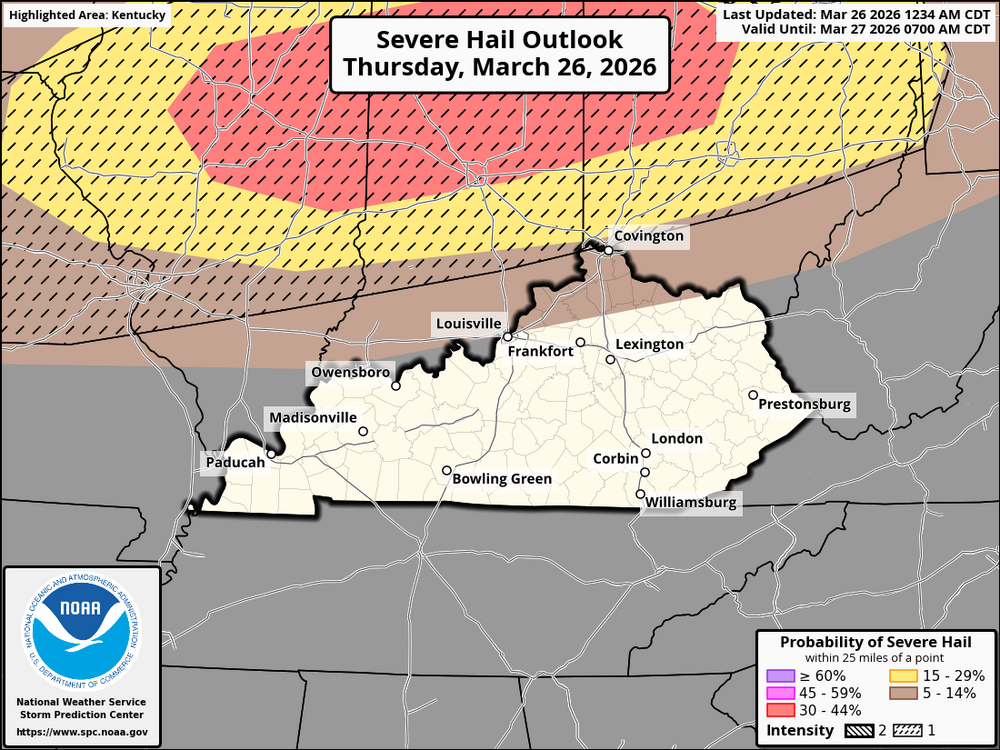
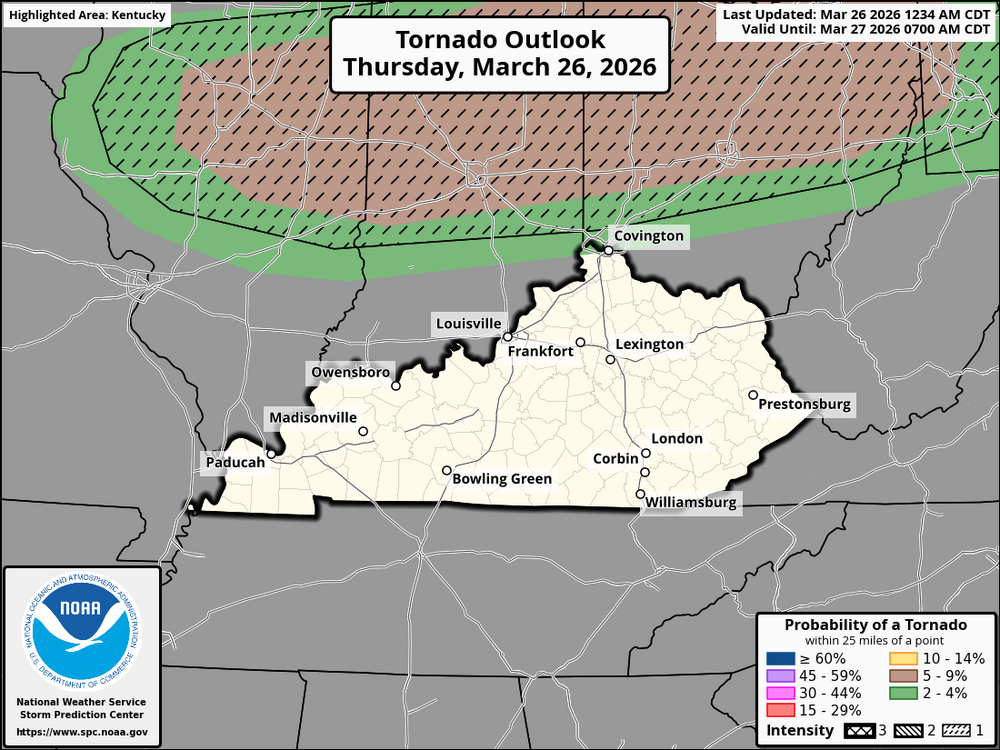
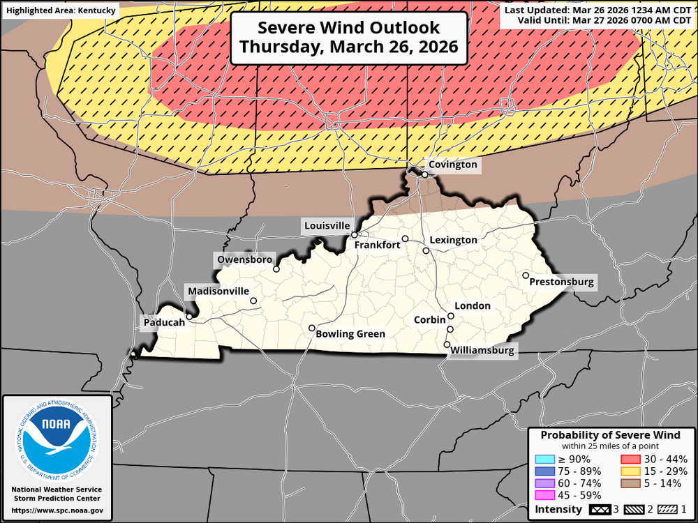
Cincinnati and Northern Kentucky Weather Update: Thunderstorms are forecasted to form along a weather front that goes from central Illinois to the east, covering parts of Indiana, southern Lower Michigan, and northern Ohio, including Cincinnati and northern Kentucky. This is expected to start in the late afternoon, with the storms becoming stronger as the evening goes on. Thunderstorms: At first, we should see a combination of powerful storm cells and lines of thunderstorms because the air will become more unstable. Hail: These storm systems might produce large to very large hail, especially in the beginning of the storms. Wind: As the storms change, we may see them shift into more linear shapes, which could lead to very strong winds. Gusts could reach between 60 and 75 mph or even higher, with some areas possibly experiencing gusts above 75 mph. There's a small chance of tornadoes, especially close to weak areas of low pressure or swirling winds within the storm line. The powerful storm cells might have the highest chance for tornadoes, particularly where the winds turn to come from the south. The storms are likely to start developing between 3:00 PM and 5:00 PM local time, with the most intense storm activity happening from 5:00 PM to 9:00 PM. The strongest storms will probably impact locations from Cincinnati north and east into northern Kentucky. The storms will begin as separate powerful cells but are expected to change into more organized lines as the afternoon goes on. This change will be due to stronger winds in the middle of the atmosphere that help the storms organize better, which means a bigger risk of strong winds. The main risks for our area will include damaging winds, large hail, and a few possible tornadoes. Be ready for quick changes in the weather, especially if you are in northern Kentucky or Cincinnati. Be watchful for any severe weather alerts and announcements throughout the afternoon and night. Important Steps to Take: Make sure you have an emergency kit prepared in case the power goes out or there are other problems from the storm. Watch the sky and check local weather reports for news, because the weather can change fast with this kind of storm.
-
During the morning to early afternoon, anticipate tranquil conditions with dry weather throughout the area. Temperatures will rise swiftly to the lower to mid-80s by early afternoon. Dewpoints will rise into the upper 50s to around 60°F in advance of the approaching cold front. By early evening, the cold front will move toward the area in the afternoon. As the front moves forward, the likelihood of thunderstorm formation will increase, featuring powerful, rotating updrafts and the potential for supercells, particularly in the initial phases. Significant hail, potentially damaging, may occur with the initial storms. As the front moves south, powerful wind gusts may also arise. A threat of tornadoes is present due to the rotating updrafts, especially with the supercells positioned in front of the storm line. There is a question regarding whether this situation will extend to the Cincinnati area. In the evening, a more structured line of storms (MCS) is expected to develop as the cold front moves southward. Destructive winds are anticipated to gain significance, particularly as low-level jet (LLJ) winds intensify throughout the evening. Thunderstorms are expected to strengthen as they approach Cincinnati and northern Kentucky, bringing strong winds, intense rainfall, and the possibility of small to medium-sized hail. After midnight, storms are expected to diminish as they move toward the Ohio River, with conditions slowly improving after 12 AM. Temperatures will drop quickly after the front passes, with conditions dropping to the mid-50s by early morning.
-
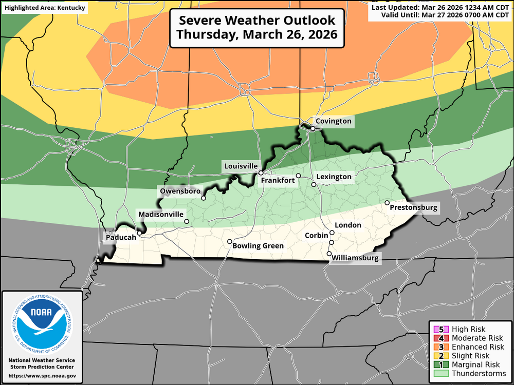
The newest water-vapor imagery indicates an upper wave heading into the Pacific Northwest and northern Rockies, with its effects likely reaching the Great Lakes area by late Thursday. Surface observations show the initial stages of a low-pressure system forming in the northern High Plains, with southerly winds from the Gulf Coast moving into the Plains. Although moisture return is currently low, dewpoints in the upper 50s to low 60s are expected to move into the Midwest and Ohio Valley by Thursday afternoon ahead of a cold front advancing southeast. In Kentucky and the Cincinnati region, this situation will create increasing instability as the cold front nears. By Thursday afternoon, scattered strong to severe thunderstorms are anticipated, especially as the cold front passes through. The combination of strengthening mid-level winds and the destabilizing air mass will set the stage for severe weather. Residents in Kentucky and the Cincinnati area should be ready for possible thunderstorms with strong winds, hail, and heavy rain, particularly late in the afternoon and evening.
-
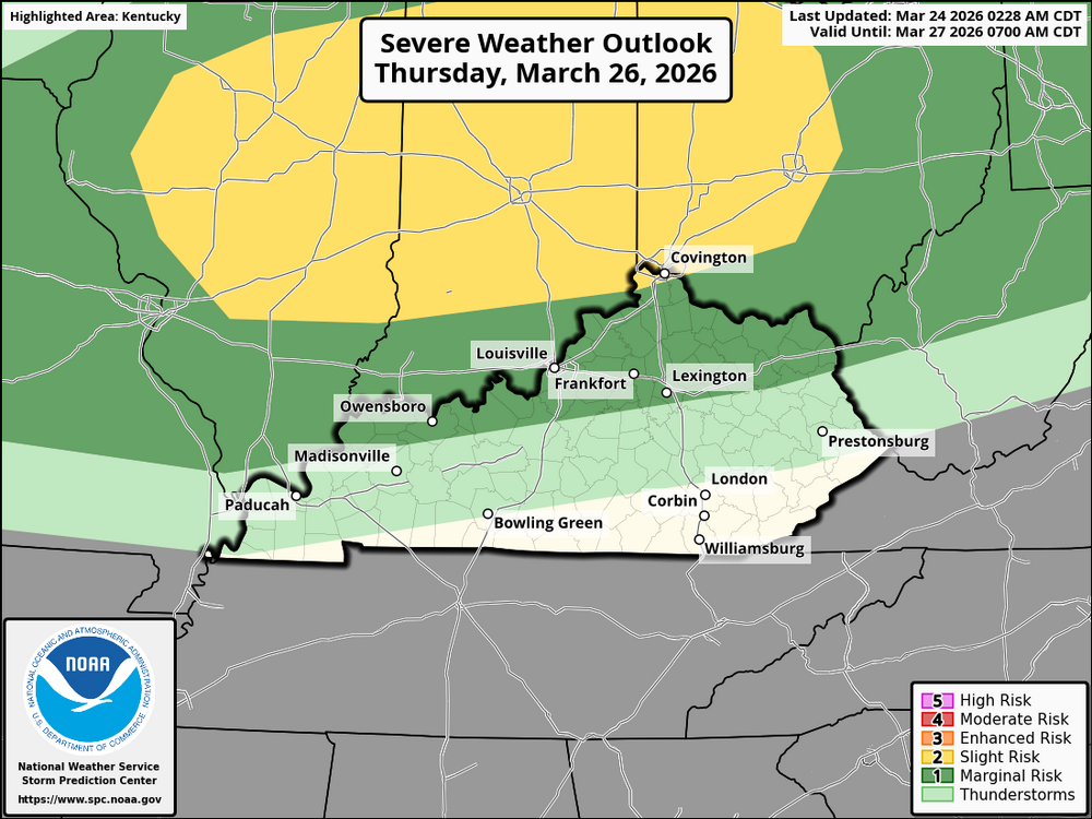
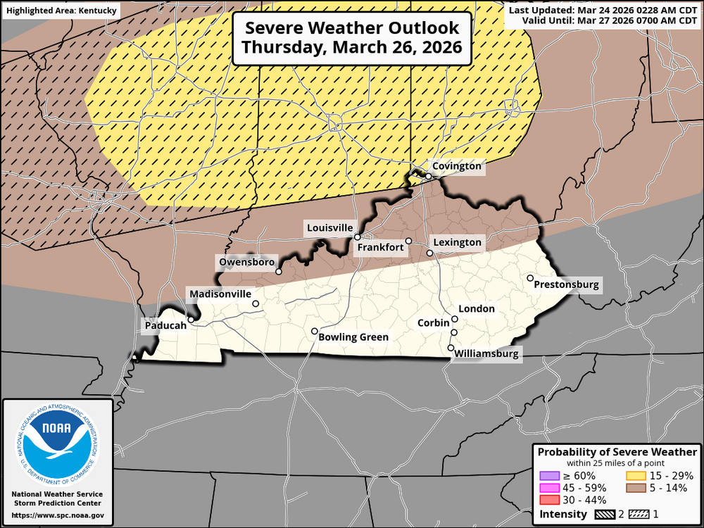
The current atmospheric configuration indicates that a major weather system will impact the area between now and Thursday, March 26, 2026. Strong southerly winds are beginning to draw rich moisture northward as a prominent upper-level ridge approaches the south-central United States. As a cold front approaches, dewpoints are expected to rise across much of Kentucky and the Cincinnati area by Thursday afternoon, resulting in a more volatile atmosphere. Thursday afternoon and evening will be the busiest hours for worry in the Cincinnati metro area and Northern Kentucky. As the cold front moves southeast, the returning moisture will most likely result in a line of severe thunderstorms. The current data point to a high likelihood that these storms will develop into convection bands. As the storms intensify into the evening hours, the primary threat to residents in the Cincinnati area and along the I-71 corridor is the possibility of damaging straight-line winds. As you travel further south and west into central and western Kentucky, the prediction becomes more difficult to make. Some atmospheric models predict that limited broad-scale lift and "capping" (a layer of warm air aloft) may further restrict storm formation, even if the main frontal boundary eventually passes through. If storms break through this barrier, they may form semi-discrete supercells rather than a continuous line. Although less certain, the risk in this case may increase to include the possibility of an isolated tornado and large hail. The severe threat is predicted to move into eastern Kentucky and towards the Appalachians by Thursday night. However, the storms are expected to decrease in intensity as they move east because of diminished buoyancy and lower nighttime temperatures. As the system nears the West Virginia border, the general belief in widespread severe weather diminishes, even if some locations like the Kentucky Bluegrass and eastern mountains may still be at risk from a persistent wind threat. Since the precise timing of the frontal passage will determine whether the worst of the weather occurs during the afternoon's peak heating or later in the evening, residents throughout the area should check local reports on Thursday. The Cincinnati and Covington area is in a level 2 out of 5 slight risk area with a CIG 1 intesity level.
-
Temperature Outlook: Kentucky is bracing for a change as a large area of high pressure moves east across the United States. While the East Coast may experience cooler air from Canada at first, temperatures in Kentucky are expected to rise steadily. As strong high-pressure systems approach the Ohio Valley, the weather in the state will change from normal to much warmer than usual. By the beginning of April, the unusually warm weather is expected to spread into the Mississippi and Ohio Valleys, potentially leading to daytime temperatures much higher than what is typical for late March. Precipitation Outlook: The rainfall prediction for Kentucky indicates that it will be wetter than usual. A low-pressure system is expected to pass through the Middle and Lower Mississippi Valleys and have an impact on the state. This system, combined with the wet air from the surrounding area, increases the likelihood that the region will receive more rain than usual (40-50% or more). Unlike in the Southwest, where chances are influenced by dry weather patterns, the situation in the Ohio Valley is based on active storms and widespread agreement among weather models. The Climate Prediction Center (CPC) has issued a warning for a slight chance of heavy rain in the Ohio Valley from March 31 through April 6. This prediction is supported by strong agreement among key weather models, which show a weather pattern moving out of the Southwest and forming low-pressure systems over the High Plains by the end of March. As this low-pressure weather system and a cold front move toward the Mississippi and Ohio Valleys, the combination of moisture and unstable air in the atmosphere increases the likelihood of thunderstorms. People in the area should keep an eye out for organized storm activity, as this can frequently lead to more serious severe weather threats for the region.
-
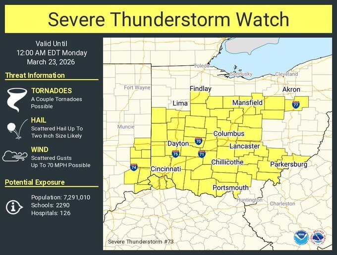
URGENT - IMMEDIATE BROADCAST REQUESTED Severe Thunderstorm Watch Number 73 NWS Storm Prediction Center Norman OK 540 PM EDT Sun Mar 22 2026 The NWS Storm Prediction Center has issued a * Severe Thunderstorm Watch for portions of Southeast Indiana Far Northern Kentucky Ohio * Effective this Sunday afternoon from 540 PM until Midnight EDT. * Primary threats include... Scattered large hail likely with isolated very large hail events to 2 inches in diameter possible Scattered damaging wind gusts to 70 mph possible A tornado or two possible SUMMARY...Scattered strong to severe storms will likely continue to develop near the front, with additional development expected farther north this evening along/north of the front, with large hail and damaging winds possible. The severe thunderstorm watch area is approximately along and 60 statute miles north and south of a line from 50 miles west southwest of Dayton OH to 15 miles east northeast of Zanesville OH. For a complete depiction of the watch see the associated watch outline update (WOUS64 KWNS WOU3). PRECAUTIONARY/PREPAREDNESS ACTIONS... REMEMBER...A Severe Thunderstorm Watch means conditions are favorable for severe thunderstorms in and close to the watch area. Persons in these areas should be on the lookout for threatening weather conditions and listen for later statements and possible warnings. Severe thunderstorms can and occasionally do produce tornadoes.