.png.ffa34568722b20f38e3c3ecfcb9a2cd2.png)


nWo
-
Posts
25,550 -
Joined
-
Last visited
-
Days Won
1
Everything posted by nWo
-
My plan at this time is to be up around 2 am to start BGP coverage of the early morning storms.
-
Cloud cover will be key. If the morning storms clear out fast enough to allow the sun to shine, It will not be a good afternoon tomorrow.
-
One thing mentioned during the conference call about Tuesday's event is the morning convection. If it ends early and the sun comes out and warms the atmosphere, that will not be good for anyone tomorrow afternoon. Ohio is really under the gun for tomorrow. Tornado watches are a practical guarantee for tomorrow.
-
I'm on a conference call with the National Weather Service-Louisville office. Confidence is high in the severe storms tonight after midnight. Louisville area around 12–2 am. Cincinnati/NKY, 4–7 am.
-
Tuesday afternoon and evening look to be the potential for a large-scale, severe weather outbreak, possibly including a few large/long-track tornadoes. The Ohio region has the highest potential of an outbreak, which might move south and into the Tennessee Valley. Cincinnati/NKY is now classified as a level 4 Moderate Risk region. At the beginning of the period, widespread thunderstorms with a slight probability of all-hazards severe weather are expected to sweep quickly eastward across the Ohio Valley region. By late morning or midday, this convection should arrive in the central Appalachians; however, it should primarily shift far enough east to allow warm-sector destabilization to begin, even though it might have some effect on the potential for destabilization throughout the MDT and ENH risk zones. Storm redevelopment is anticipated during the afternoon as the cold front proceeds across the Mid-Mississippi and Lower Ohio Valleys as the surface low deepens, traverses Illinois, and finally moves into Indiana. It is still challenging to identify the evolution/storm mode, partly because of past storms, but some combination of cellular and cluster/linear modes should evolve. All-hazards severe potential, including extremely huge hail, strong/damaging winds, and numerous substantial tornadoes, is clear given the considerable instability forecast in conjunction with very strong/veering deep-layer flow. The biggest risk is expected to start across Indiana and move across Ohio through the afternoon and evening, with the possibility of a few strong, long-track tornadoes.

-
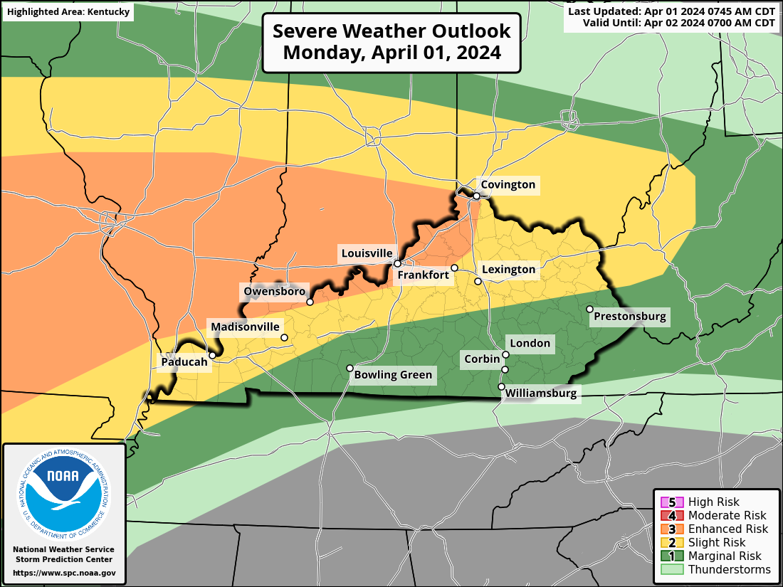
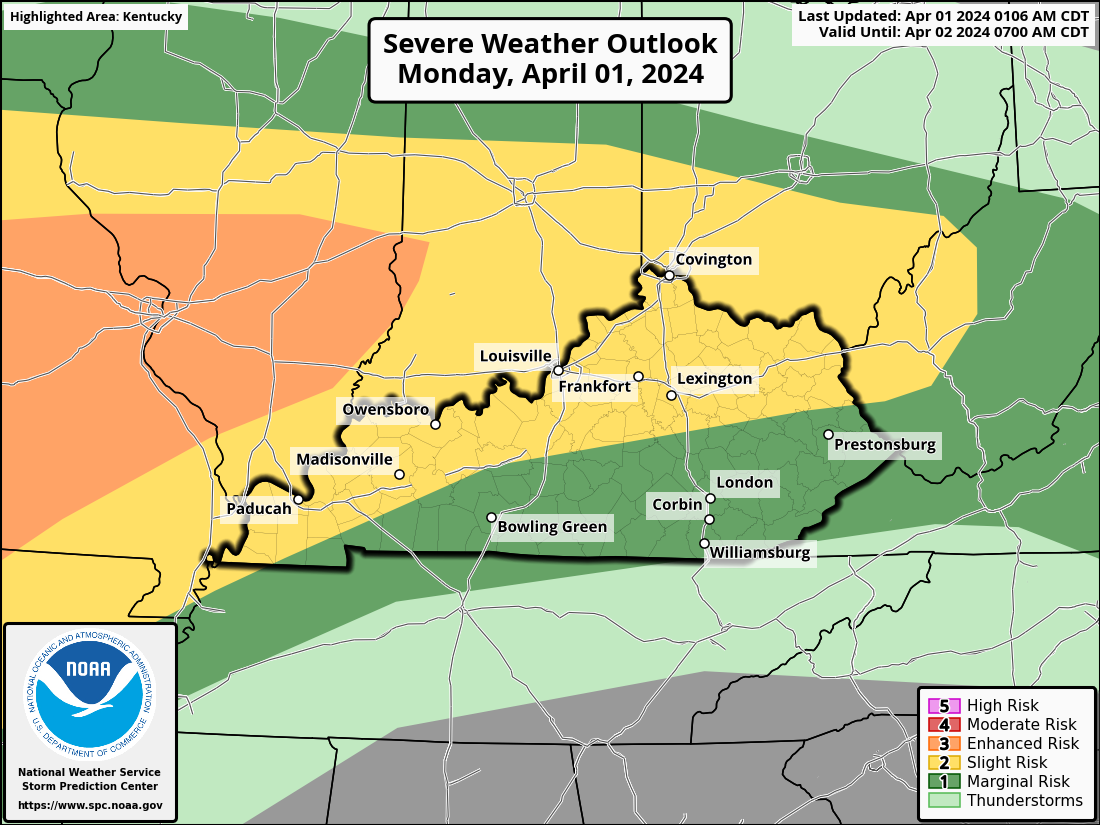
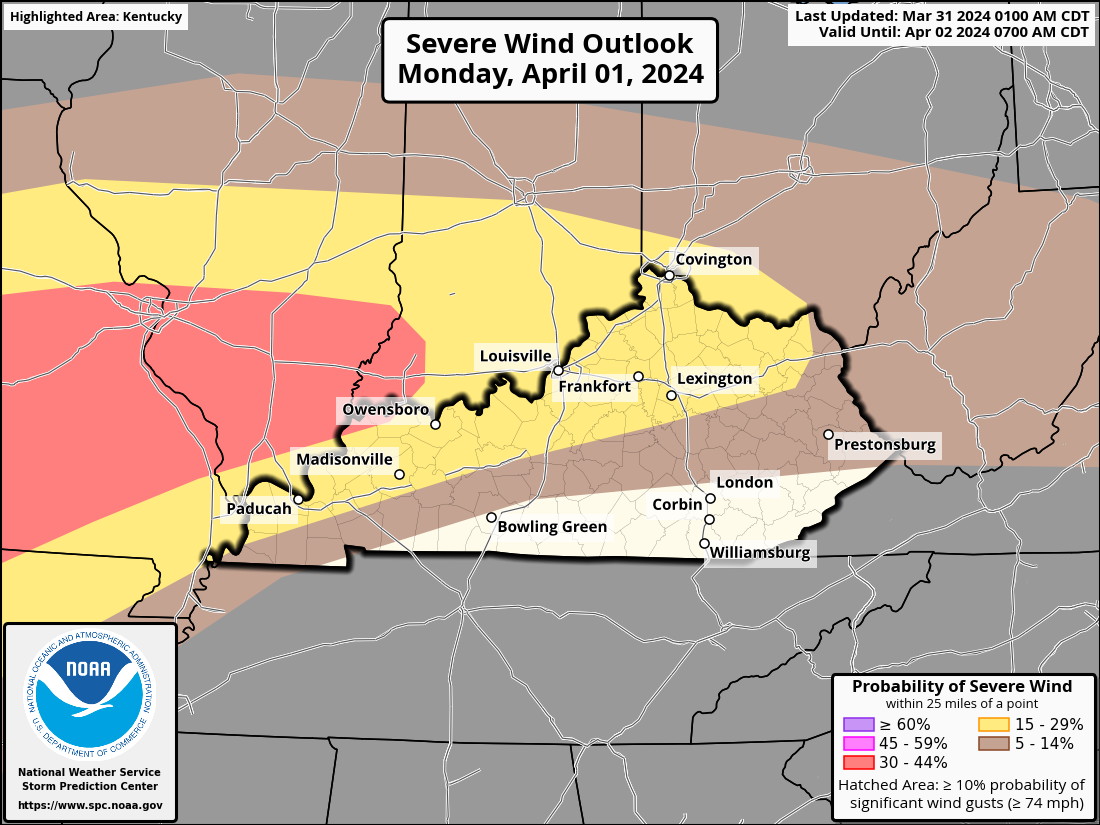
Here's the latest SPC Convective Outlook for today. Sections of Kentucky are now under a level 3 Enhanced Risk Area. This includes the cities of Owensboro, Louisville, and Covington.
-
I will be utilizing the SPC Mesoscale Analysis EMC RAP model for the first time. It gauges the rotational velocity of both the upper and lower atmospheres. This is the map I created to show the region I believe will have the highest probability of seeing a tornado.
-
-
-
-
-
-
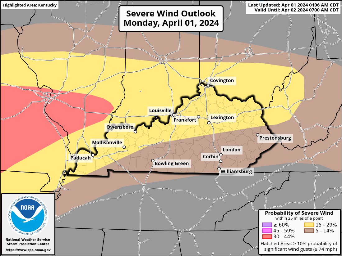
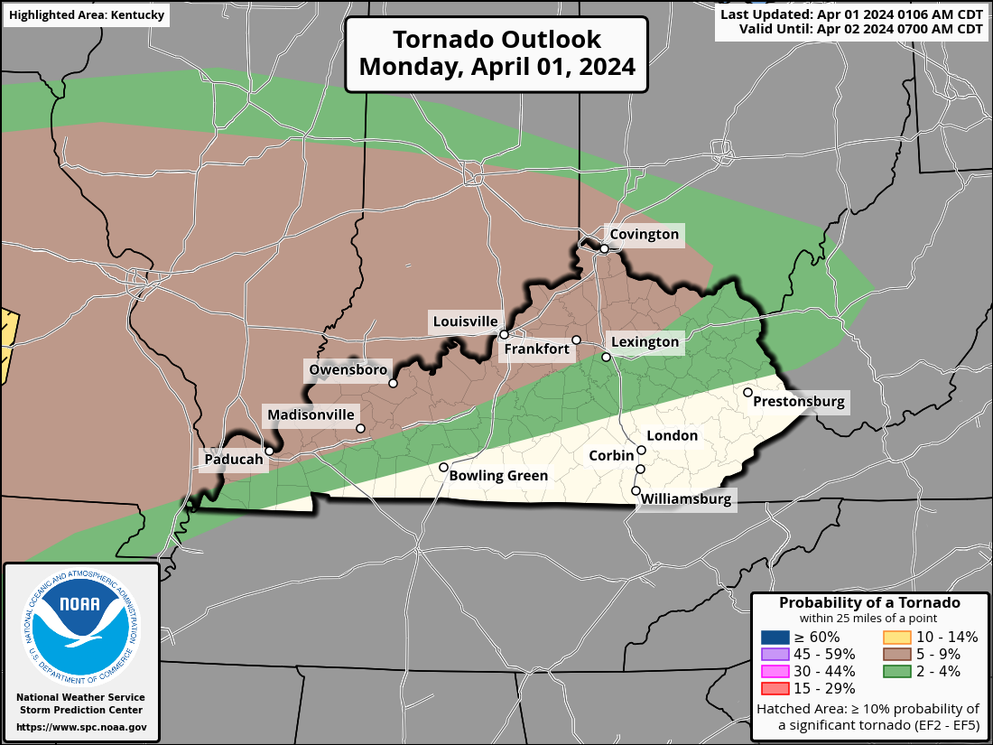
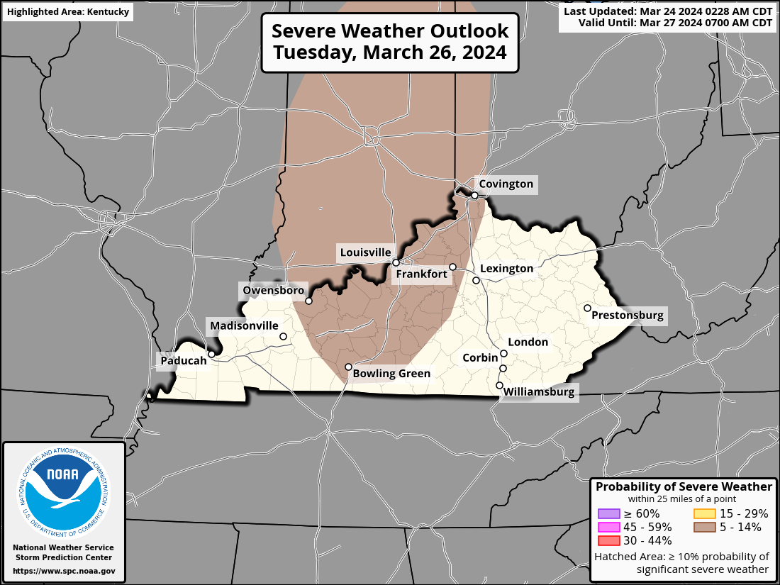
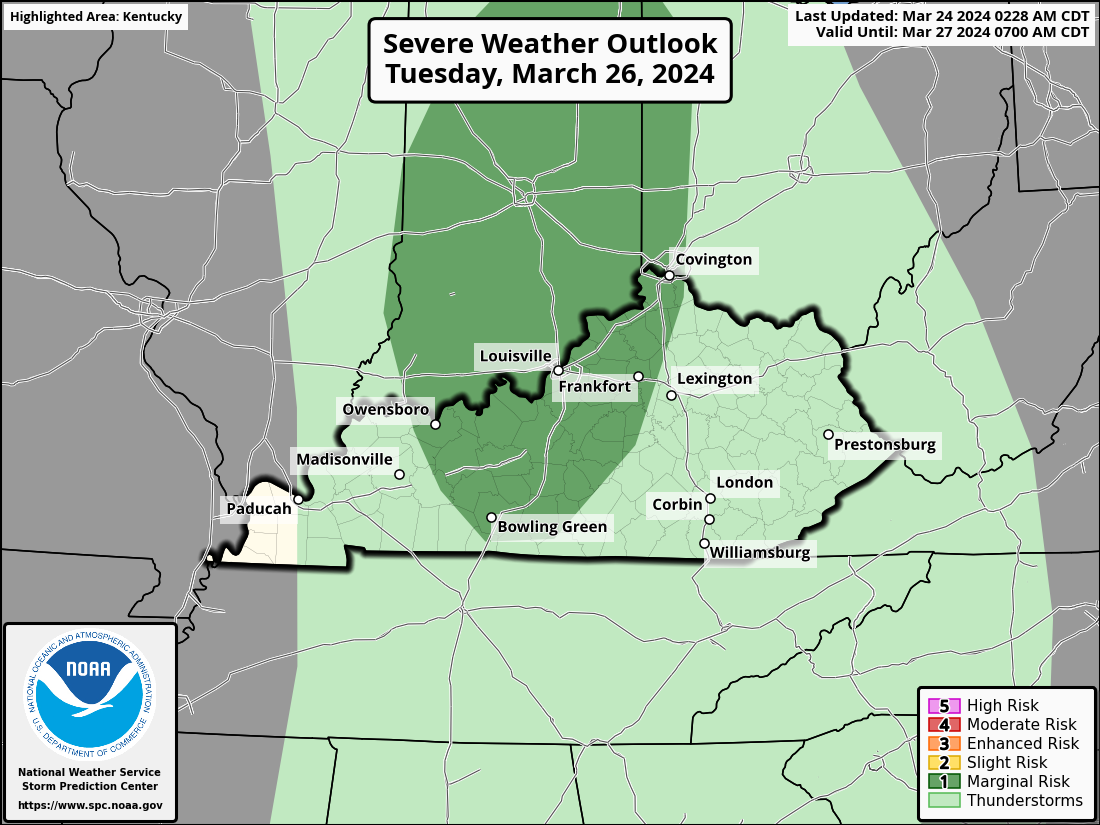
On Tuesday, there is anticipated to be a serious threat from the Tennessee and Ohio Valleys. Over a wide area, there will be a chance of wind damage and sporadic huge hail. The area of middle Tennessee and northeastward into central and northern Kentucky is predicted to be the most dangerous for tornadoes. Tuesday afternoon will see the best conditions for the formation of a squall line. There will probably be multiple embedded severe storms in this linear cluster of thunderstorms, with wind damage posing the biggest concern. It is anticipated that the risk of wind damage will be at its highest in the late afternoon and early evening. There will be places on the line where tornadic circulations are likely, particularly in the vicinity of segments that bend. In locations where the squall line interacts with locally increased instability and with isolated rotating cells that form ahead of the line, there is also a chance of isolated huge hail. As the line passes across the central Appalachians, a reduction in the severe threat is anticipated in the mid-to-late evening hours. Check back for an update later today.
-
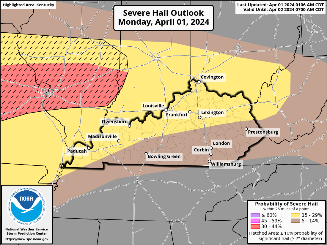
A wide swath of the region, including parts of the Ohio Valley, the southern Plains, the Ozarks, and a tiny bit of the Mid-Atlantic, is predicted to see severe weather. There is a chance of large to very large hail, powerful tornadoes, and damaging winds. In the southern Plains, the severe threat will peak this afternoon/evening, with the evening/overnight period posing the worst threat to the Ohio Valley region. Supercells from Illinois might cross southern Indiana and possibly southern Ohio in the evening as they move eastward with the warm front. Along this frontal zone, other storms may also form, with huge hail being the main threat. Compared to storms further west, these storms should pose less of an overall threat because to weaker instability and shear. On the other hand, a threat of big hail, destructive wind gusts, and maybe a tornado will be supported by severe shear and moderate instability. A ring of storms is predicted to move in from the west during the course of the night. A serious threat will still be supported by the nocturnal environment. The future evolution of this cluster is still rather unknown. All severe weather threats would be at risk from a cluster of supercells, although a more organized MCS might support a greater severe wind and QLCS (squall line) tornado threat.
-
This afternoon through Tuesday, the area will see periodic showers and thunderstorms brought on by a powerful spring storm system. The majority of the threat from the most widespread severe weather is predicted to occur from after midnight on Monday night through Tuesday afternoon, even if isolated to scattered severe storms are probable tonight evening through Monday, especially in southern Indiana and north central Kentucky. There will be a chance of severe hazards, particularly from late Monday through Tuesday. Make a plan in case of severe weather. Check the latest forecasts. I will post an update early Monday morning.
-
-
Tuesday update. Everyone should review their emergency action plan as soon as possible. The majority of Kentucky now faces a considerably greater risk of severe weather. The Storm Prediction Center has issued a level 3 Enhanced Risk Area for the majority of Kentucky A severe threat is expected on Tuesday from the Ohio and Tennessee Valleys eastward into the Mid-Atlantic, and southward into the central Gulf Coast states. Wind damage and isolated large hail will be possible across a broad area. The tornado threat is expected to be greatest from central Kentucky east-northeastward into West Virginia. Ohio and Tennessee Valleys/Central Appalachians/Mid-Atlantic... An upper-level trough is forecast to move into the mid- to upper Mississippi Valley on Tuesday, as a cold front advances eastward into the Ohio and Tennessee Valleys. A moist airmass will be in place ahead of the front, with surface dewpoints generally in the 60s F. As instability increases across the warm sector during the day, widespread convective initiation is expected. Numerous thunderstorms are forecast to develop across the Ohio and Tennessee Valleys, with a large MCS (collection of thunderstorms) moving eastward into the central Appalachians by evening. While supercells will be possible, the more favored mode could be multicellular, as several line segments develop and organize during the afternoon. Wind damage will be associated with the faster-moving line segments, while large hail will be most common with rotating cells. Supercells or the more intense QLCS (line of thunderstorms ahead of a cold front) circulations could develop a tornado threat. The greatest tornado threat is forecast to be from eastern Kentucky into West Virginia, where a low-level jet should become focused in the late afternoon and early evening.
-
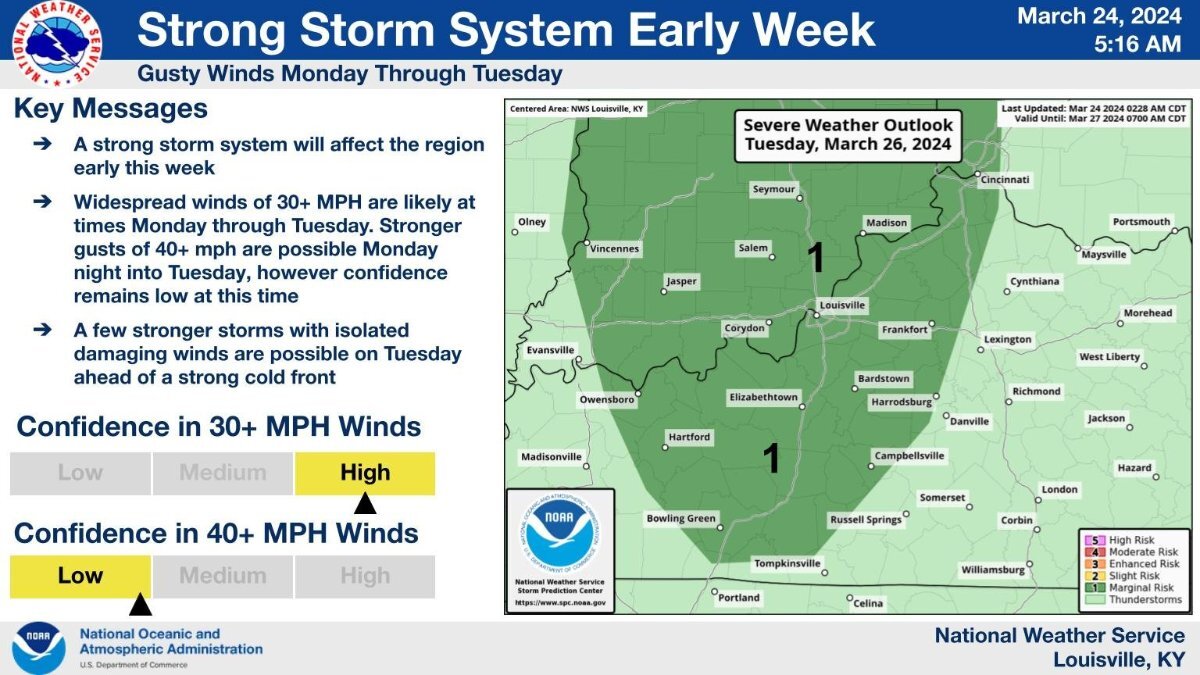
It now appears we could be in store for a multi-day severe weather event Monday evening into the afternoon on Tuesday. Western Kentucky: the best chance for strong to severe storms arriving Monday evening and overnight ahead of a cold front. Damaging winds and a few spin-up tornadoes look to be the main concerns. Much colder air arrives behind the cold front, with some frost potential Wednesday night and especially Thursday night. Temperatures can also fall below freezing locally, especially near the I-64 corridor. Central/South Central Kentucky: Strong to severe storms are possible late Monday evening through Tuesday afternoon. The best chance for severe storms Monday night will be across southern Indiana, where damaging winds, large hail, spin-up tornadoes, and localized flooding are possible. Confidence in the location and timing of strong storms on Tuesday is lower, but damaging winds, large hail, and tornadoes are all possible.
-
Update from the National Weather Service-Louisville office:
-
The April 3-4, 1974 Super Outbreak is the second largest outbreak of tornadoes on record and holds the record for the most F5 tornadoes on a single day. At least 148 tornadoes developed during the super outbreak, touching down in 13 states, killing around 335 people, and causing approximately $600 million in damages. The first tornado was reported around 9:30 am CDT on April 3 in Indiana, and the final tornado occurred around 8 am CDT on April 4 in North Carolina, with the peak occurring between 2 pm and 10 pm on April 3. Dozens of noteworthy tornadoes occurred in a very short amount of time, making the impact even more severe and the recovery process more daunting. Many of the tornadoes moved at speeds exceeding 50 mph, and two in particular followed identical paths, causing more than half of the recorded deaths from the outbreak and striking many communities twice in under an hour. States across the Midwest experienced colossal loss: Ohio, India, Kentucky, Tennessee, and Alabama had about 200 fatalities and over $80 million in damages between them as a result of the tornadoes, one of which was witnessed by NWS employees. In the aftermath of this catastrophe, it was clear that changes needed to be made, particularly in the areas of public education and awareness. Outside of the NWS, local broadcasters learned they could stay on the air beyond normal operating hours during weather emergencies, and local principalities began to utilize their Emergency Broadcast Systems far more frequently and effectively. NOAA Weather Radio (NWR) proved to be an effective means of disseminating alerts in the larger metropolitan areas during the outbreak, and as a result, NWR was expanded. https://vlab.noaa.gov/web/nws-heritage/-/the-april-1974-super-outbreak-of-tornadoes
-
Valleys of Ohio and Tennessee into the Appalachians... As the upper trough continues, there should be some serious threat over portions of the OH/TN Valleys and into the Appalachians on Tuesday. The precise location of the primary surface low and the evolution of the upper trough remain somewhat uncertain, but there is enough confidence in a somewhat narrow corridor over these regions to add a 15% severe area for Tuesday. A cold front approaching eastward should be preceded by rich, low-level moisture. It appears likely that convection may redevelop and/or intensify by Tuesday afternoon. Given the predicted severity of a low-level jet concentrated over portions of the region, strong deep-layer shear and mild instability should be sufficient for organized severe convection, offering some concern for damaging winds and maybe tornadoes.
-
-
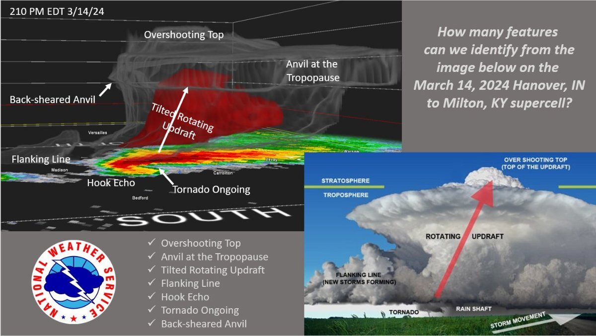
Thursday's storm was a classic example of a supercell. Look at this 3-D image of the storm, and compare its features to a textbook schematic. It dropped very large hail and produced a long-track EF-2 tornado that crossed the Ohio River three times.