.png.ffa34568722b20f38e3c3ecfcb9a2cd2.png)

.jpg.67ca52c6df25163f3af009c91bda1717.jpg)
nWo
-
Posts
25,586 -
Joined
-
Last visited
-
Days Won
2
Everything posted by nWo
-
The atmosphere will destabilize again this afternoon. The destabilization will be more intense this afternoon and more widespread.
-
URGENT - IMMEDIATE BROADCAST REQUESTED Tornado Watch Number 73 NWS Storm Prediction Center Norman OK 655 AM EDT Tue Apr 2 2024 The NWS Storm Prediction Center has issued a * Tornado Watch for portions of Southern Indiana Central and Northern Kentucky * Effective this Tuesday morning from 655 AM until NOON EDT. * Primary threats include... A few tornadoes possible Scattered damaging winds likely with isolated significant gusts to 75 mph possible Isolated large hail events to 1.5 inches in diameter possible SUMMARY...A severe squall line will continue to move east across portions of the Ohio Valley this morning. A few tornadoes are possible with the stronger storm-scale circulations embedded within the line, in addition to the risk for scattered severe gusts. The tornado watch area is approximately along and 50 statute miles north and south of a line from 75 miles west southwest of Louisville KY to 55 miles east northeast of Lexington KY. For a complete depiction of the watch see the associated watch outline update (WOUS64 KWNS WOU3). PRECAUTIONARY/PREPAREDNESS ACTIONS... REMEMBER...A Tornado Watch means conditions are favorable for tornadoes and severe thunderstorms in and close to the watch area. Persons in these areas should be on the lookout for threatening weather conditions and listen for later statements and possible warnings.

-
URGENT - IMMEDIATE BROADCAST REQUESTED Tornado Watch Number 72 NWS Storm Prediction Center Norman OK 200 AM CDT Tue Apr 2 2024 The NWS Storm Prediction Center has issued a * Tornado Watch for portions of Southern Illinois Southwest Indiana Western Kentucky Southeast Missouri * Effective this Tuesday morning from 200 AM until 800 AM CDT. * Primary threats include... A couple tornadoes possible Scattered damaging wind gusts to 70 mph likely Scattered large hail events to 1.5 inches in diameter possible SUMMARY...A broken band of thunderstorms will continue to move east-northeast across the Watch overnight into the early morning. Severe thunderstorms capable of damaging gusts are possible, in addition to a risk for a couple of tornadoes with the more intense cells or line segments. The tornado watch area is approximately along and 45 statute miles north and south of a line from 30 miles south southwest of Farmington MO to 40 miles northeast of Evansville IN. For a complete depiction of the watch see the associated watch outline update (WOUS64 KWNS WOU2). PRECAUTIONARY/PREPAREDNESS ACTIONS... REMEMBER...A Tornado Watch means conditions are favorable for tornadoes and severe thunderstorms in and close to the watch area. Persons in these areas should be on the lookout for threatening weather conditions and listen for later statements and possible warnings.
-
SUMMARY...Severe thunderstorm potential is expected through late morning across parts of northern Kentucky, southern Indiana and southwest Ohio. Damaging gusts and a tornado or two will be possible with this activity and a watch will likely be needed in the next hour. DISCUSSION...Upstream convection across southern IL/western KY into southwest IN will continue to spread generally east this morning. While instability remains modest across the region, strong vertical shear is present and favorable for continued organized convection. An increase in lightning trends across southern IL and the background CAPE/shear environment suggest this activity will continue within the vicinity of an effective outflow/stationary front draped across southern IL/IN/southwest OH. Damaging gusts will be possible with generally linear/bowing storm mode. However, enlarged, curved low-level hodographs and 0-1 km SRH greater than 200 m2/s2 suggest some tornado risk also will accompany this activity. A tornado watch downstream from WW 72 will likely be needed in the next hour. It should be noted that additional severe potential will overspread this same area again later this afternoon
-
I'll be back on later this morning. I woke up at 1:30 this morning to go over the situation. I got some things to do this morning and then got a little rest. People may not know this, but covering these events can be quite draining.
-
ttt
-
What I observed in the most recent HRRR modeling data is as follows:. I am not fond of what I am witnessing. As far north as middle Ohio, dew points, or tornado juice, could reach the mid-to-upper 60s. This is causing a large, severe weather event, in addition to other upper and lower atmospheric circumstances. Breaks in the cloud cover before this afternoon are another serious issue. More atmospheric destabilization will be possible as a result of the breaks. Early in the afternoon is when the intense convection should start, and as the day goes on, it should get stronger. I sincerely hope I am mistaken, but I can not stress enough how much everyone reading this needs to get in touch with friends and family by this afternoon to make sure they are prepared.
-
Latest update: Overnight, there has been an increase in the serious threat for this afternoon. A level 3 Enhanced Risk Area covers nearly the whole state of Kentucky. A level 4 Moderate Risk Area now covers portions of the state from the I-64 corridor northward. A small area in western Kentucky is classified as a level 2 Slight Risk Area. A possibly substantial severe weather outbreak is anticipated for this afternoon and overnight, with the Ohio Valley having the highest probability. A few large/long-track tornadoes could be part of the outbreak. It seems like things are becoming dangerous here. Now is the time for everyone to start getting ready. Examine or start using your emergency action plan. Maintain many avenues of communication for potential alerts related to your region. I will be keeping a careful eye on this and posting updates as soon as the data allows me to.
-
The first round of tomorrow's storms should be in your area between 4 and 7 am.
-
I agree I do the same thing.
-
Correct. If that does indeed happen, they say it doesn't matter what level of threat we are under; it won't be good for anyone.
-
My plan at this time is to be up around 2 am to start BGP coverage of the early morning storms.
-
Cloud cover will be key. If the morning storms clear out fast enough to allow the sun to shine, It will not be a good afternoon tomorrow.
-
One thing mentioned during the conference call about Tuesday's event is the morning convection. If it ends early and the sun comes out and warms the atmosphere, that will not be good for anyone tomorrow afternoon. Ohio is really under the gun for tomorrow. Tornado watches are a practical guarantee for tomorrow.
-
I'm on a conference call with the National Weather Service-Louisville office. Confidence is high in the severe storms tonight after midnight. Louisville area around 12–2 am. Cincinnati/NKY, 4–7 am.
-
Tuesday afternoon and evening look to be the potential for a large-scale, severe weather outbreak, possibly including a few large/long-track tornadoes. The Ohio region has the highest potential of an outbreak, which might move south and into the Tennessee Valley. Cincinnati/NKY is now classified as a level 4 Moderate Risk region. At the beginning of the period, widespread thunderstorms with a slight probability of all-hazards severe weather are expected to sweep quickly eastward across the Ohio Valley region. By late morning or midday, this convection should arrive in the central Appalachians; however, it should primarily shift far enough east to allow warm-sector destabilization to begin, even though it might have some effect on the potential for destabilization throughout the MDT and ENH risk zones. Storm redevelopment is anticipated during the afternoon as the cold front proceeds across the Mid-Mississippi and Lower Ohio Valleys as the surface low deepens, traverses Illinois, and finally moves into Indiana. It is still challenging to identify the evolution/storm mode, partly because of past storms, but some combination of cellular and cluster/linear modes should evolve. All-hazards severe potential, including extremely huge hail, strong/damaging winds, and numerous substantial tornadoes, is clear given the considerable instability forecast in conjunction with very strong/veering deep-layer flow. The biggest risk is expected to start across Indiana and move across Ohio through the afternoon and evening, with the possibility of a few strong, long-track tornadoes.
-
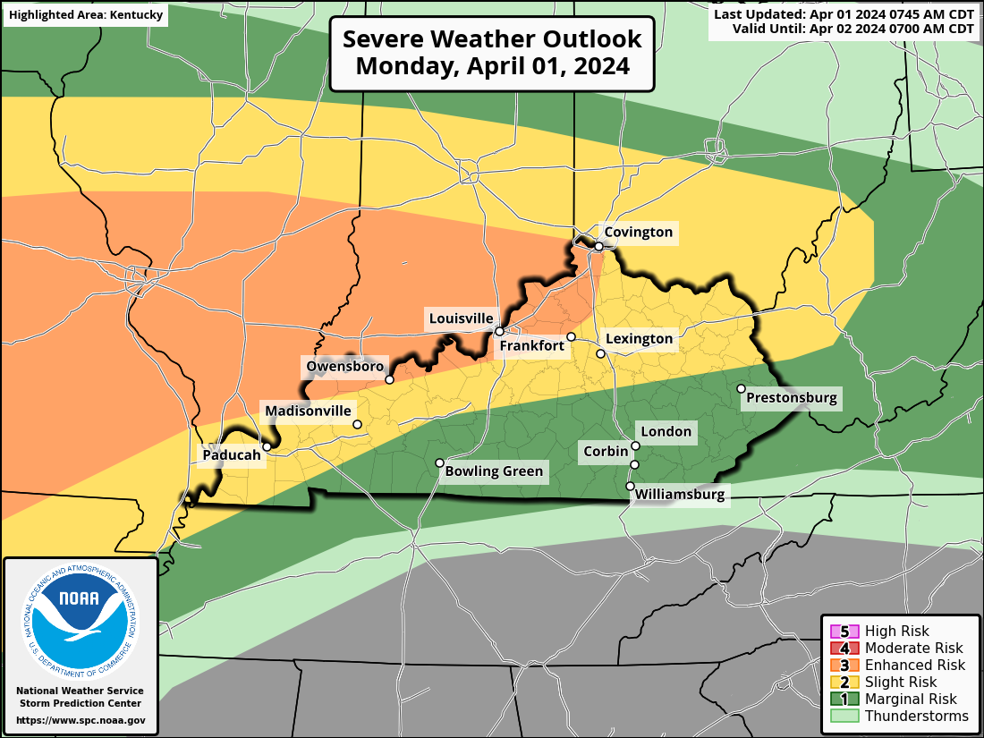
Here's the latest SPC Convective Outlook for today. Sections of Kentucky are now under a level 3 Enhanced Risk Area. This includes the cities of Owensboro, Louisville, and Covington.
-
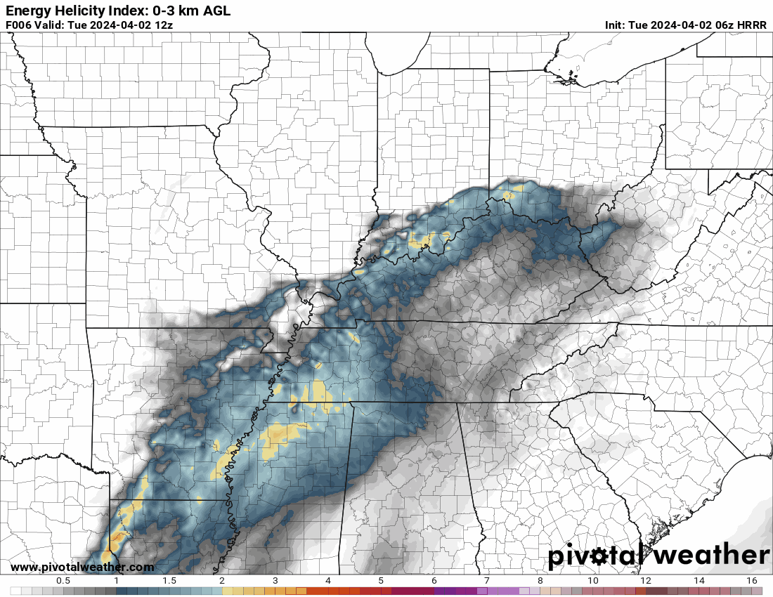
I will be utilizing the SPC Mesoscale Analysis EMC RAP model for the first time. It gauges the rotational velocity of both the upper and lower atmospheres. This is the map I created to show the region I believe will have the highest probability of seeing a tornado.
-
-
-
-
-
-
On Tuesday, there is anticipated to be a serious threat from the Tennessee and Ohio Valleys. Over a wide area, there will be a chance of wind damage and sporadic huge hail. The area of middle Tennessee and northeastward into central and northern Kentucky is predicted to be the most dangerous for tornadoes. Tuesday afternoon will see the best conditions for the formation of a squall line. There will probably be multiple embedded severe storms in this linear cluster of thunderstorms, with wind damage posing the biggest concern. It is anticipated that the risk of wind damage will be at its highest in the late afternoon and early evening. There will be places on the line where tornadic circulations are likely, particularly in the vicinity of segments that bend. In locations where the squall line interacts with locally increased instability and with isolated rotating cells that form ahead of the line, there is also a chance of isolated huge hail. As the line passes across the central Appalachians, a reduction in the severe threat is anticipated in the mid-to-late evening hours. Check back for an update later today.
.thumb.jpg.d475a671bdc851f901dea439c04b8f9d.jpg)