

nWo
BGP Meteorologist
-
Joined
-
Last visited
Everything posted by nWo
-
-
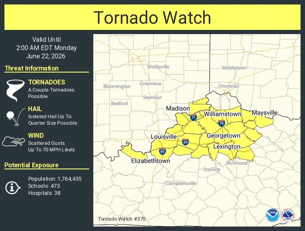
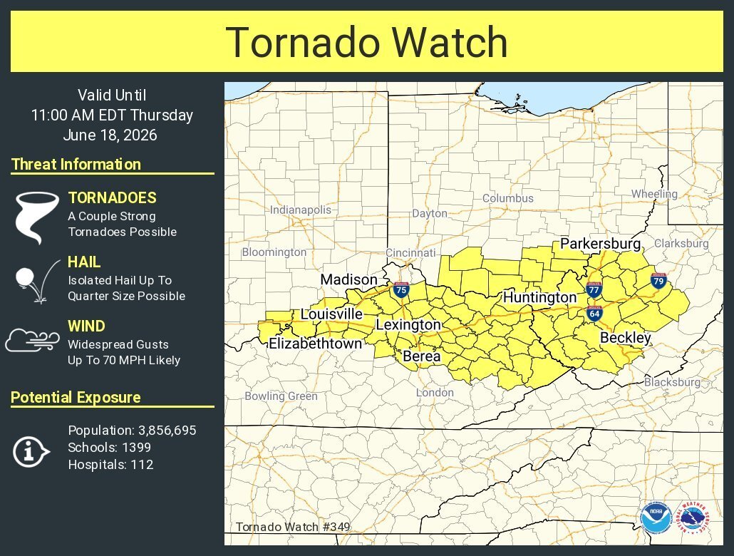
URGENT - IMMEDIATE BROADCAST REQUESTED Tornado Watch Number 370 NWS Storm Prediction Center Norman OK 915 PM EDT Sun Jun 21 2026 The NWS Storm Prediction Center has issued a * Tornado Watch for portions of Far Southeast Indiana Central and Northern Kentucky * Effective this Sunday night and Monday morning from 915 PM until 200 AM EDT. * Primary threats include... A couple tornadoes possible Scattered damaging wind gusts to 70 mph likely Isolated large hail events to 1 inch in diameter possible SUMMARY...A broken cluster of supercells and line segments are expected to move into the Watch area from the west this evening. A couple of tornadoes are possible with the more intense thunderstorms. Scattered damaging straight-line winds will also probably accompany the more intense cells and embedded bows/inflections within the cluster of thunderstorms. The tornado watch area is approximately along and 30 statute miles north and south of a line from 30 miles west of Louisville KY to 50 miles northeast of Lexington KY. For a complete depiction of the watch see the associated watch outline update (WOUS64 KWNS WOU0). PRECAUTIONARY/PREPAREDNESS ACTIONS... REMEMBER...A Tornado Watch means conditions are favorable for tornadoes and severe thunderstorms in and close to the watch area. Persons in these areas should be on the lookout for threatening weather conditions and listen for later statements and possible warnings. @theguru
-
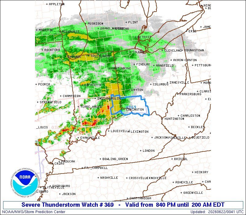
SEL9 URGENT - IMMEDIATE BROADCAST REQUESTED Severe Thunderstorm Watch Number 369 NWS Storm Prediction Center Norman OK 840 PM EDT Sun Jun 21 2026 The NWS Storm Prediction Center has issued a * Severe Thunderstorm Watch for portions of Southeast Indiana Northern Kentucky Southwest Ohio * Effective this Sunday night and Monday morning from 840 PM until 200 AM EDT. * Primary threats include... Scattered damaging wind gusts to 70 mph possible Isolated large hail events to 1 inch in diameter possible A tornado or two possible SUMMARY...A band of severe thunderstorms will move east into the Watch area this evening. Scattered damaging gusts are possible with the more intense portions of the thunderstorm band. A tornado is possible, especially over western portions of the Watch area where slightly richer moisture and strong low-level shear may support a brief period of embedded rotation with the thunderstorm line. The severe thunderstorm watch area is approximately along and 25 statute miles north and south of a line from 50 miles west northwest of Cincinnati OH to 55 miles east of Cincinnati OH. For a complete depiction of the watch see the associated watch outline update (WOUS64 KWNS WOU9). PRECAUTIONARY/PREPAREDNESS ACTIONS... REMEMBER...A Severe Thunderstorm Watch means conditions are favorable for severe thunderstorms in and close to the watch area. Persons in these areas should be on the lookout for threatening weather conditions and listen for later statements and possible warnings. Severe thunderstorms can and occasionally do produce tornadoes. @theguru
-
I know. There are severe, powerful tornadoes on the ground in Indiana.
-
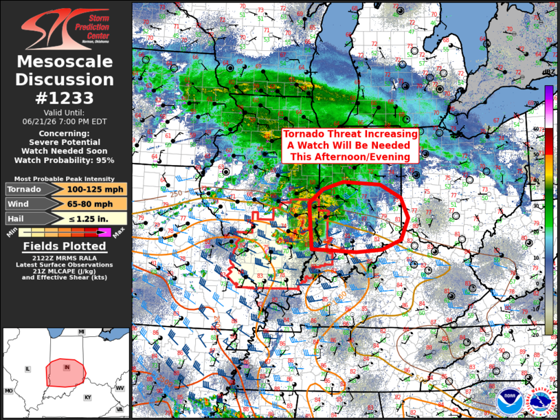
Those in the Cincinnati/NKY area should be weather-aware this evening. Mesoscale Discussion 1233 NWS Storm Prediction Center Norman OK 0423 PM CDT Sun Jun 21 2026 Areas affected...Southern and Central Indiana Concerning...Severe potential...Watch needed soon Valid 212123Z - 212300Z Probability of Watch Issuance...95 percent SUMMARY...The tornado threat is increasing across portions of southern Indiana as thunderstorms with a history of producing tornadoes across southern Illinois move east into the area. A tornado watch will be needed soon. DISCUSSION...Several supercells with a history of producing tornadoes have developed this afternoon across portions of southern Illinois in association with a convectively augmented vorticity maximum moving east within zonal mid-level flow. Ahead of these supercells, a surface boundary is slowly lifting northward across portions of Indiana. To the south of this boundary, surface dewpoints have risen into the 60Fs to low 70Fs contributing to MLCAPE values between 500-1000 J/kg. Along the boundary easterly low-level flow will maximize storm-relative helicity, as indicated by the Indianapolis VAD (KIND) which suggests around 300 m2/s2. The result will be a continued tornado threat this evening across portions of southern and central Indiana and a tornado watch will be required soon. @theguru
-
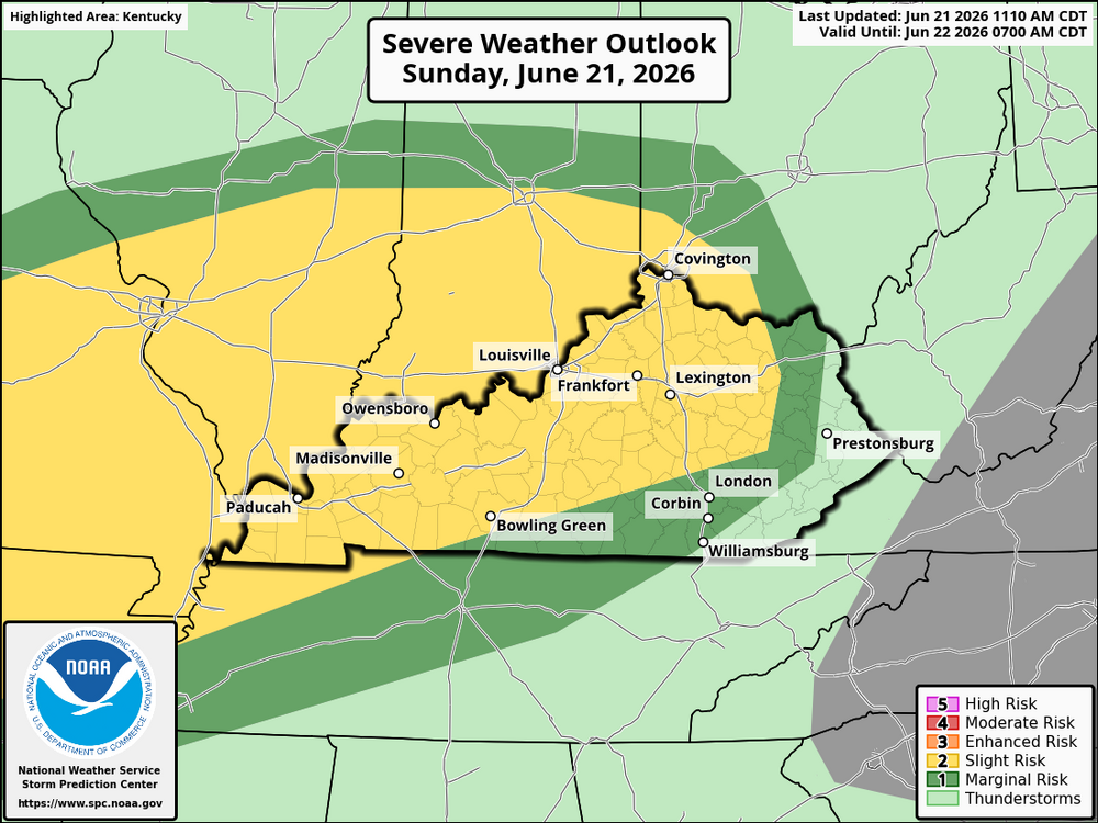
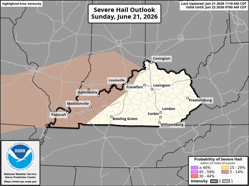
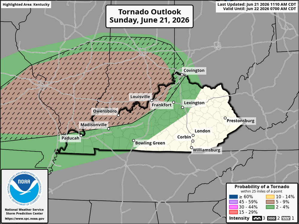
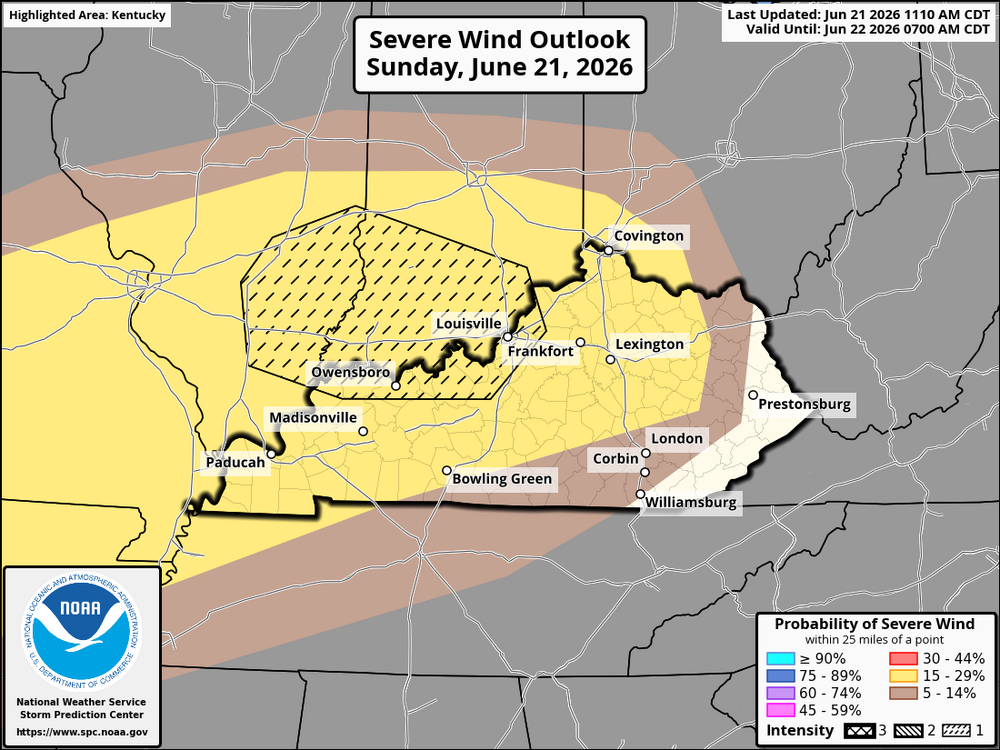
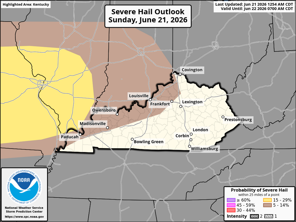
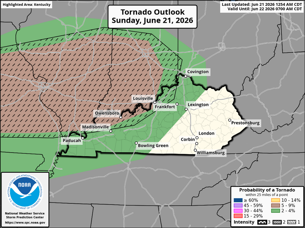
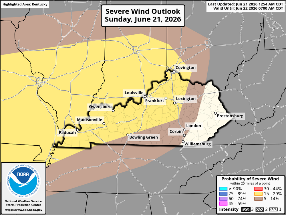
Update: Thunderstorms are expected to increase across Kentucky this afternoon and evening as a well-organized line of storms moves east out of Missouri and into the Ohio Valley. Warm, humid air combined with increasing instability will provide a favorable environment for storms to strengthen as they enter the state. The greatest severe weather threat will be across northern, central, and eastern Kentucky, where storms are expected to become more intense through the afternoon and continue into the overnight hours. While a few storms could initially develop into rotating supercells capable of producing isolated tornadoes, the overall storm mode is expected to evolve into one or more fast-moving lines capable of widespread damaging wind gusts. The main threats across Kentucky will be damaging straight-line winds of 60 to 75 mph, isolated tornadoes, frequent cloud-to-ground lightning, torrential rainfall that may lead to localized flooding, and hail up to around quarter size in the strongest storms. Storms are expected to move into western Kentucky late this afternoon, spread across central Kentucky during the evening, and reach eastern Kentucky overnight while gradually weakening. Even so, severe storms may persist well into eastern Kentucky before exiting early Monday morning. Residents across Kentucky should remain weather aware throughout the afternoon, evening, and overnight hours, as warnings may be issued with little lead time and conditions could deteriorate quickly.
-
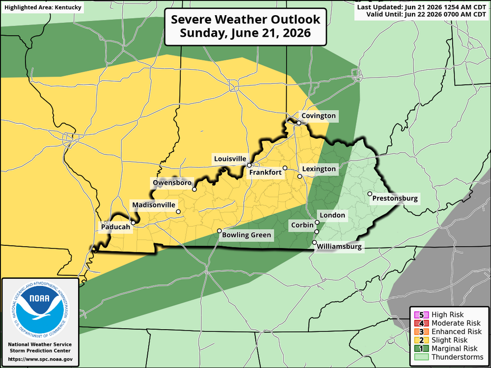
A potentially significant severe weather event is expected across parts of Kentucky this afternoon and evening as a strong storm system moves east from Missouri into the Ohio Valley. While there is still some uncertainty regarding the exact track and intensity of the strongest storms, the environment will be capable of supporting organized severe thunderstorms. Storms are expected to move into western Kentucky during the afternoon before spreading east across central Kentucky and eventually into eastern portions of the state through the evening and early night. If enough sunshine develops ahead of the storms, the atmosphere will become increasingly unstable, allowing thunderstorms to intensify quickly. The primary threats will be widespread damaging wind gusts capable of producing scattered tree damage and power outages, along with large hail. A few tornadoes are also possible, especially across western and central Kentucky, where wind shear will be strongest. An isolated strong tornado cannot be ruled out if discrete supercells are able to develop ahead of or within the main line of storms. Storms may organize into a line with embedded rotating cells as they track eastward, allowing the severe weather threat to continue well into the evening. The greatest risk currently appears to be across western and central Kentucky, with the threat gradually shifting into eastern Kentucky during the evening before storms weaken overnight. Main Threats: Damaging winds of 60 to 80 mph capable of downing trees and power lines, large hail, a few tornadoes with the possibility of an isolated strong tornado, torrential rainfall leading to localized flash flooding, and dangerous cloud-to-ground lightning. Residents across Kentucky should remain weather-aware throughout the day and have multiple ways to receive warnings, as conditions could change quickly. Even with some forecast uncertainty, severe weather could develop rapidly with little advance notice.
-
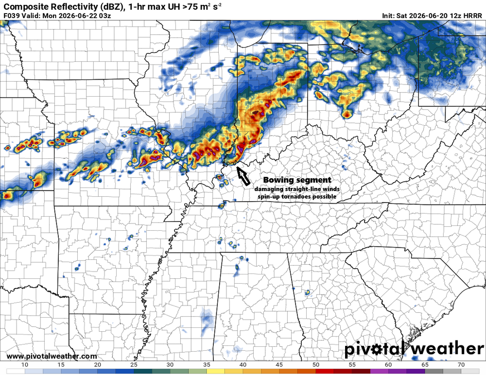
I've noticed some bowing in the lines in the HRRR simulated radar for tomorrow evening and early morning Monday. The bulge could be the most violent part of the system. Usually produces severe straight-live winds that could cause significant wind damage. The northern tip of the bow could create a high risk of brief tornadoes. These need to be watched to see if they actually form.
.thumb.png.2be00980df02850cd4c54574eb8ae269.png)
-
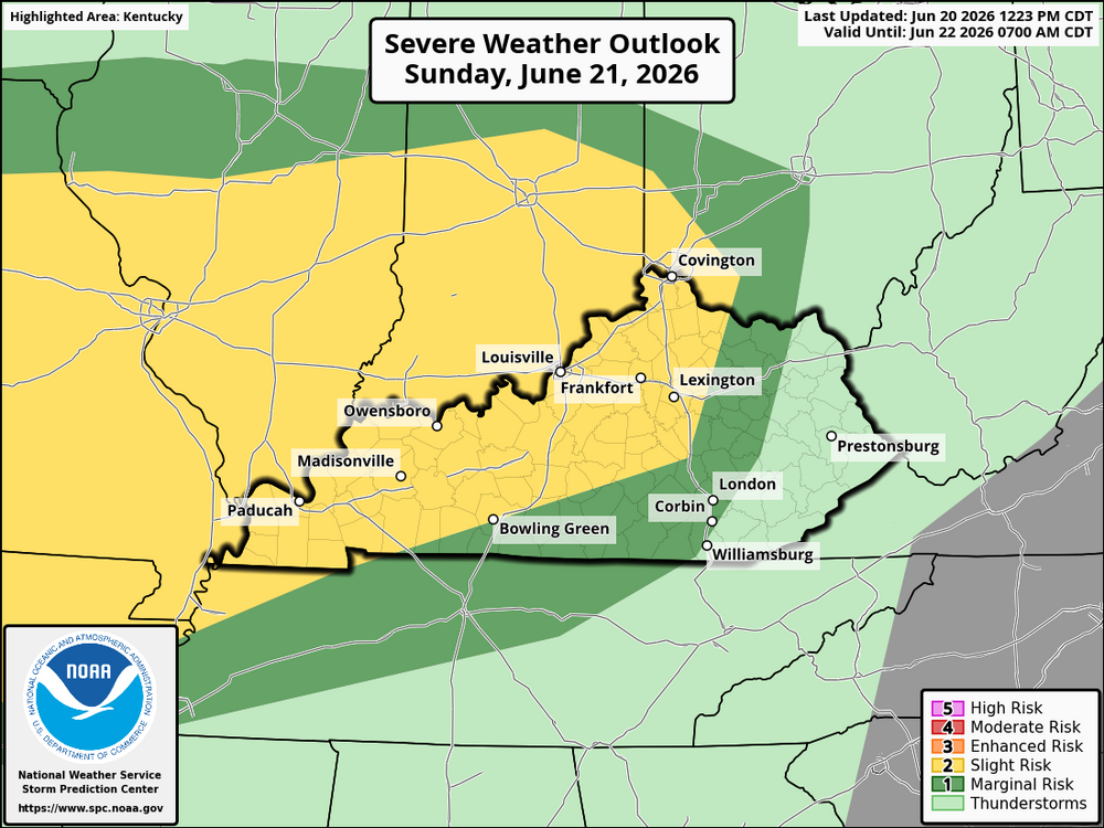
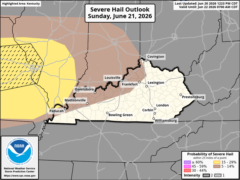
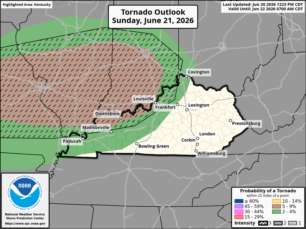
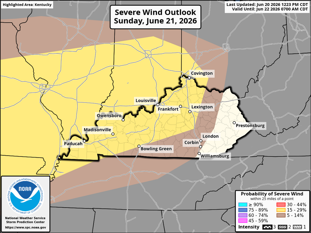
For Kentucky, the primary severe weather threat is expected to arrive later Sunday as thunderstorms developing over Illinois and Indiana move east into the Ohio Valley. While the most significant risk for widespread severe weather, including strong tornadoes, is forecast to remain northwest of the state across parts of Missouri, Illinois, and Indiana, some of these storms could maintain strength as they approach western and northern Kentucky. The atmosphere over Kentucky is expected to become increasingly warm, humid, and unstable during the afternoon and evening as moisture returns behind any morning storm activity. This will create a favorable environment for thunderstorms capable of producing damaging wind gusts, large hail, frequent lightning, and torrential rainfall. The greatest severe weather risk appears to be across western and north-central Kentucky, with storms potentially spreading eastward during the evening and overnight hours. Forecast confidence decreases farther east across the state because the exact position of the outflow boundary left behind by earlier storms remains uncertain. Small shifts in this boundary will determine where the strongest storms develop and track. While the highest-end severe threat is expected to remain just northwest of Kentucky, residents across much of the state should closely monitor forecasts, as a few storms could become severe if the atmosphere recovers as anticipated. Damaging straight-line winds appear to be the primary concern, although an isolated tornado cannot be ruled out, especially near any lingering boundaries.
-
An area of low pressure will move into the lower Great Lakes region on Sunday, with a threat of thunderstorms later Sunday afternoon into the late evening. Confidence is steadily growing in all severe threats (including a tornado threat). Areas along and west of I-65 in western Kentucky have the highest chance of seeing strong to severe thunderstorms late Sunday, while central Kentucky could see storms weaken somewhat as they move east depending on atmospheric recovery. Eastern Kentucky appears to have the lowest severe threat, though a few strong storms could still arrive Sunday evening or overnight. Forecast Confidence: Moderate, with uncertainty tied to how much the atmosphere recovers after morning thunderstorms.
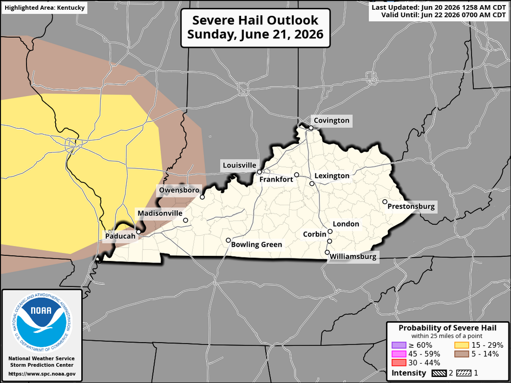
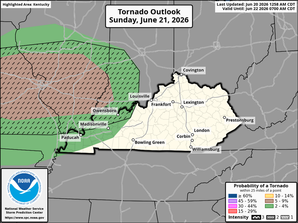
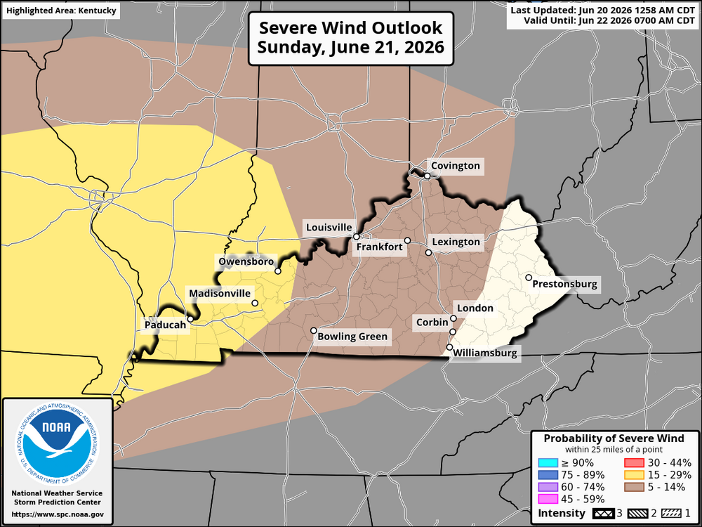
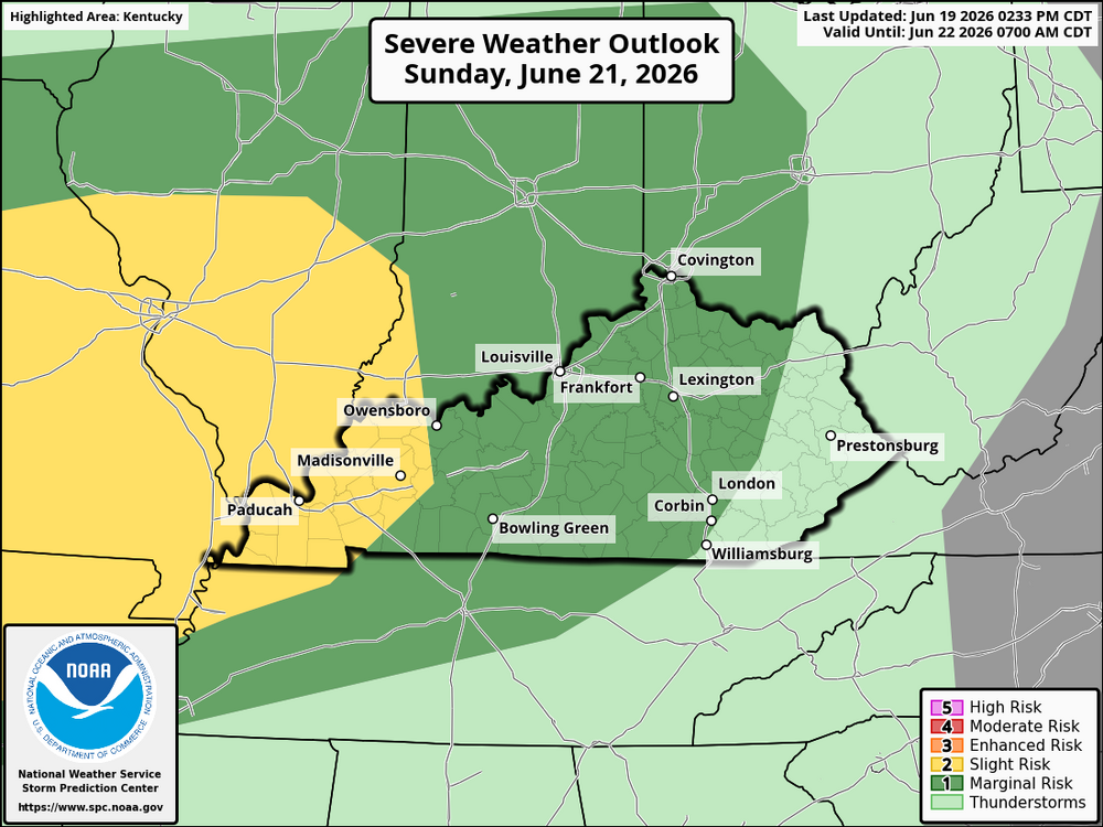
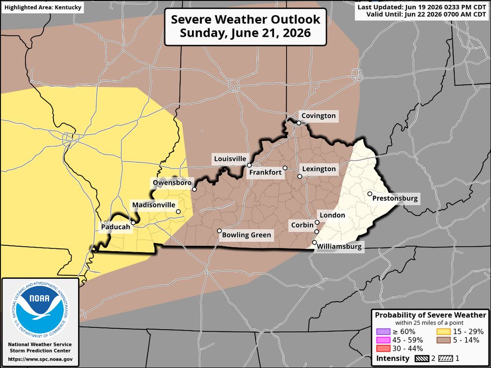
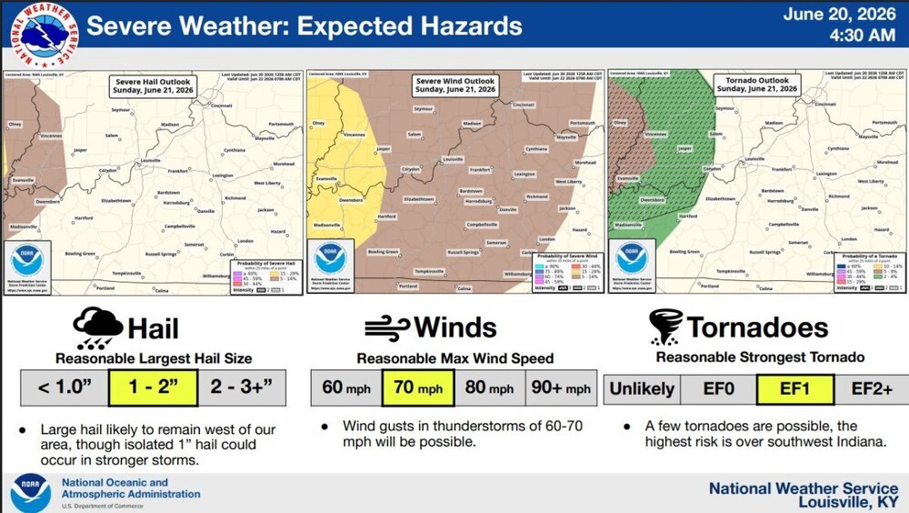 Wilmington, OH Weather Forecast Office June 17-18, 2026 -- Severe Storms and Tornadoes https://www.weather.gov/iln/20260618An area of low pressure will move into the lower Great Lakes region on Sunday, with a threat of thunderstorms later Sunday afternoon into the late evening. Confidence is steadily growing in all severe threats (including a tornado threat). Areas along and west of I-65 will see the greatest potential for severe weather. A flooding threat could also develop later Sunday and linger into Monday.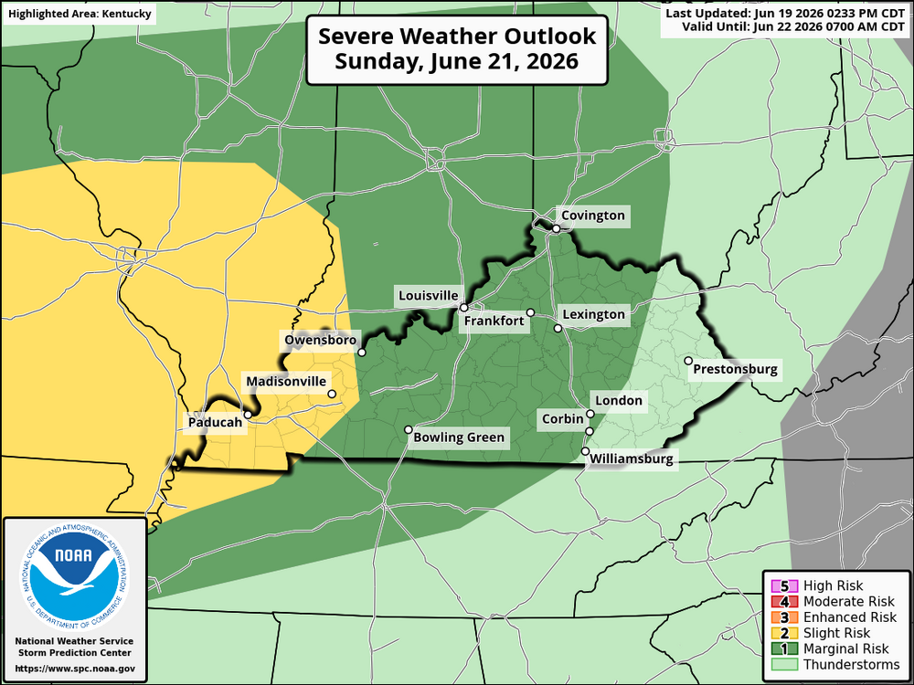
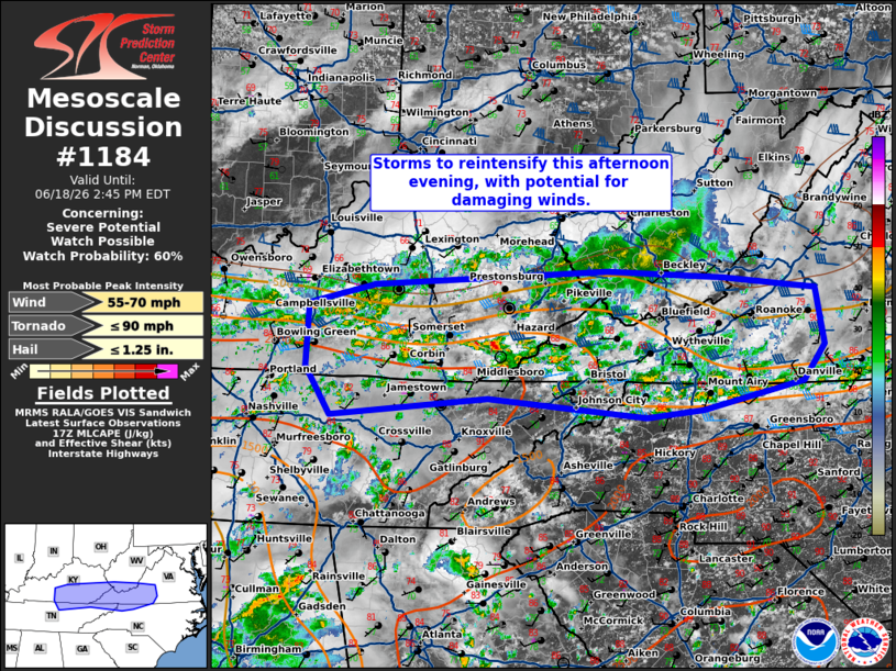
 A SWW may be issued soon. Mesoscale Discussion 1184 NWS Storm Prediction Center Norman OK 1243 PM CDT Thu Jun 18 2026 Areas affected...central/eastern Kentucky into West Virginia and the western Carolinas Concerning...Severe potential...Watch possible Valid 181743Z - 181845Z Probability of Watch Issuance...60 percent SUMMARY...Thunderstorm activity to re-intensify this afternoon with potential for damaging winds. DISCUSSION...Widely scattered thunderstorm activity continues across portions of central/eastern Kentucky into the Carolinas this afternoon. This is ongoing in the vicinity of a differential heating zone/residual outflow from morning storm activity. Daytime heating across this zone has allowed temperatures to warm into the mid 80s across southern Kentucky into northern Tennessee, with around 1500-2000 J/kg of MLCAPE analyzed in SPC Mesoanalysis. Westerly deep layer flow continues to support around 30-40 kts of boundary shear to support organization. The parallel orientation of this shear to the boundary will likely support clustering of storms and multi-cell modes. Coverage of thunderstorms will likely increase this afternoon, with potential for several clusters spreading eastward through the afternoon. The main hazard is expected to be damaging
 This afternoon, renewed thunderstorm development is expected across Kentucky along a remnant outflow boundary across the state. Strong daytime heating within a moist air mass, combined with moderate westerly winds aloft and instability of around 2000 J/kg of CAPE will support storms redeveloping along and just south of the boundary. Storms are already underway in some areas and will spread more widely through the afternoon with the primary window for stronger activity through early afternoon into early evening. The environment will be conducive to scattered to locally numerous thunderstorms that may organize into clusters or short line segments as they move east and northeast. The primary concern with these storms is damaging straight-line winds, especially in any stronger or more organized cells. Heavy rainfall will also be a significant issue, with localized flash flooding possible where storms repeatedly move over the same locations, particularly given already saturated ground in parts of central Kentucky. Small hail cannot be ruled out in the strongest updrafts, though it is a secondary threat. Storms are expected to move east through the afternoon and evening with activity expected to reach eastern Kentucky and eventually the northern Kentucky and Cincinnati area. The storms will likely weaken somewhat as they move farther east but could still produce gusty winds and heavy rain. In summary, this is your garden-variety, boundary-driven severe weather setup where coverage is spotty but any storm that develops can quickly become strong and produce impactful weather.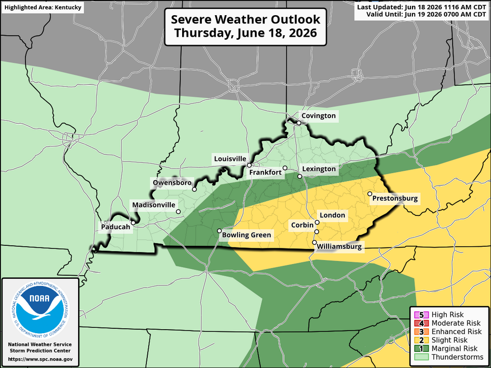
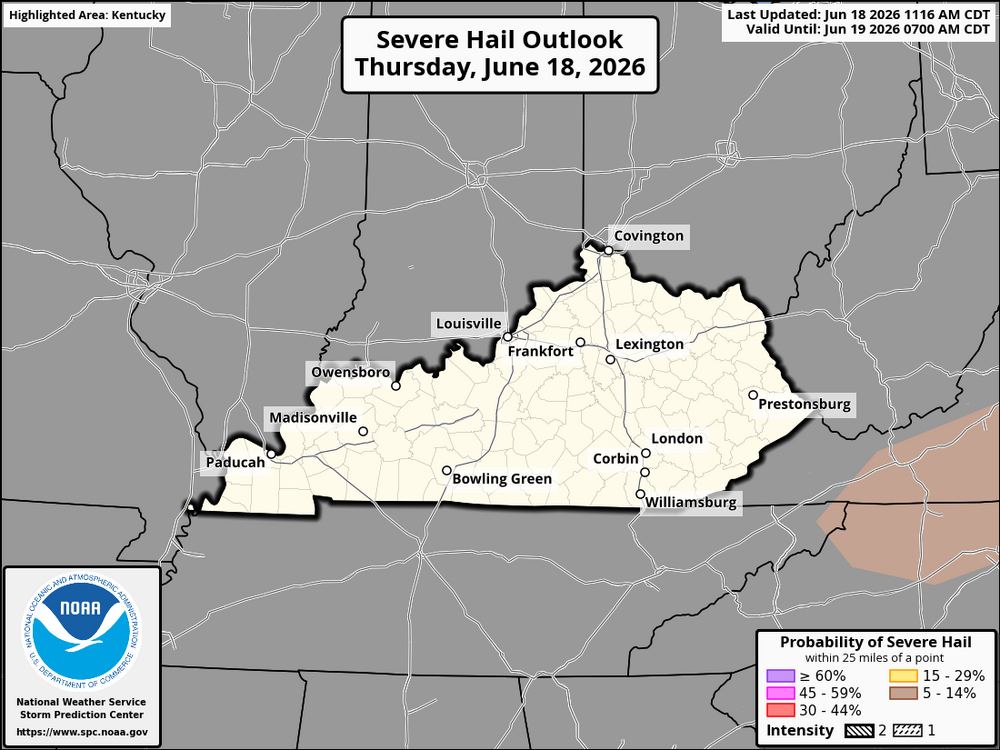
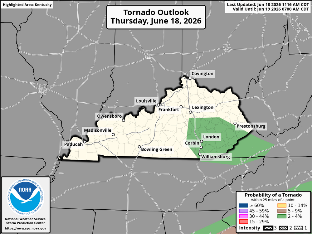
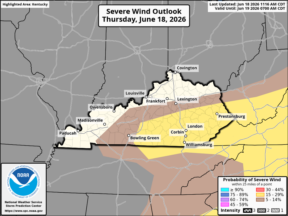 NWS-Wilmington: NOUS41 KILN 181412 PNSILN INZ066-074-KYZ091-190215- Public Information Statement National Weather Service Wilmington OH 1012 AM EDT Thu Jun 18 2026 ...Preliminary Storm Survey scheduled for today for Florence in Boone County Kentucky, near Aurora in Dearborn County Indiana, and also in eastern Franklin County Indiana... The National Weather Service office in Wilmington OH will conduct a storm survey this morning through this afternoon for the area near Florence in Boone County Kentucky, as well as near Aurora in Dearborn County Indiana, and near and east of Cedar Grove in Franklin County Indiana. The survey is in relation to the severe thunderstorms that moved through the area early this morning. We don't anticipate any preliminary determinations until at least mid to late this afternoon, but will issue a follow up preliminary damage assessment via a Public Information Statement later this afternoon.All watches have been canceled.A potentially active severe weather day is expected across Kentucky as a front moves through the Ohio Valley and interacts with a very moist and unstable air mass. Scattered storms may already be underway this morning from central and eastern Kentucky into West Virginia. A couple of these early storms may tap into some high, low-level wind shear along boundaries along with strong moisture and lift. This would pose a localized risk of short-lived tornadoes or strong wind gusts, especially with any organized morning storm clusters. Additional storms are expected to develop on and ahead of the front through late morning and into the afternoon as daytime heating increases. The environment is expected to favor organized convection, with strong deep-layer shear and near-straight-line wind profiles favoring fast-moving clusters of storms. Moisture will be plentiful, supporting vigorous updrafts and efficient storm development. The main hazards across Kentucky will be damaging straight-line winds, locally severe hail, frequent lightning, and heavy downpours. Wind damage is expected to be the primary threat, especially with fast-moving storm clusters. The tornado risk is highest early in the day when storms are more discrete or loosely organized and low-level wind shear is stronger. As the day progresses, mixing in the boundary layer and weakening low-level wind profiles should reduce tornado potential somewhat, although it will not drop to zero. Any storm interacting with local boundaries could still briefly rotate. Regionally, central and eastern Kentucky will likely see the most widespread storm activity, with both morning and afternoon rounds possible. Western Kentucky may see more scattered storms depending on frontal timing, but any storms that do develop could still produce damaging winds and hail. Northern Kentucky and the Cincinnati metro area may see fast-moving storm clusters, with damaging winds as the main concern and a low but nonzero early-day tornado risk. Overall, Kentucky is facing a setup favoring multiple rounds of storms, with the greatest risk coming from damaging winds, isolated hail, and a brief early-day tornado threat that gradually decreases as the atmosphere mixes out.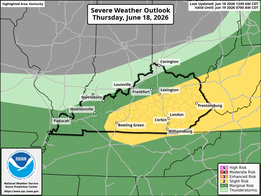
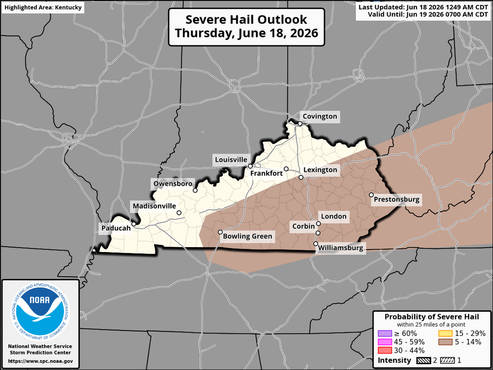
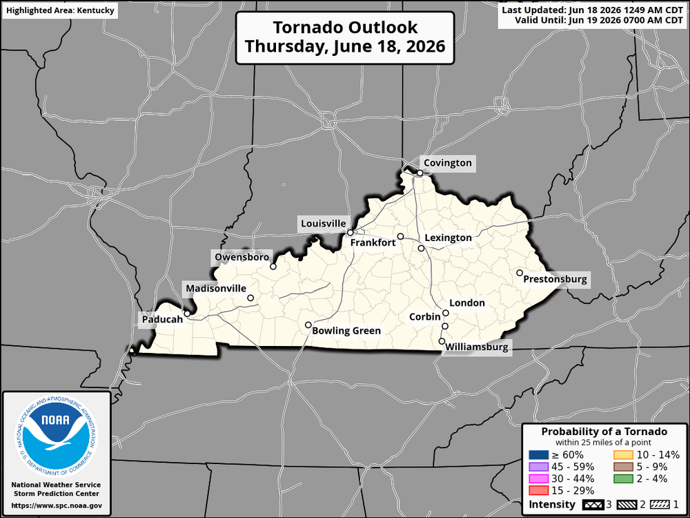
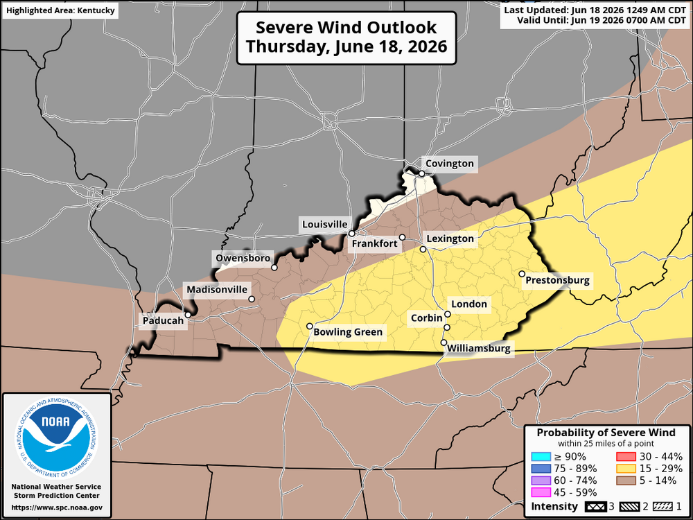 Here is the latest forecast from the information just released about 20 minutes ago. For this evening the threat level has increased for portions of Kentucky and the Cincinnati area Across Kentucky, including Northern Kentucky (NKY) and the Cincinnati metro area, conditions are expected to become increasingly favorable for severe storms from late afternoon into tonight as a powerful storm system moves through the Midwest into the Ohio Valley. During the day, warm and humid air will build across the region, with breaks in cloud cover helping the atmosphere destabilize. This will set the stage for thunderstorms to develop or move in from the west later this afternoon and evening. The main concern window for NKY and Cincinnati appears to be late afternoon through the overnight hours. Storms arriving from Indiana or developing along outflow boundaries could become strong to severe, with the primary threats including damaging straight-line winds, large hail, and heavy rainfall. There is also a conditional tornado risk if storms can organize into discrete supercells or remain well-structured as they cross into the area. Western and central Kentucky may see the earliest impacts, with activity potentially consolidating and spreading eastward toward NKY and Cincinnati later this evening and into the night. Timing and exact storm mode remain uncertain due to the complex setup, but the environment is supportive of rapid storm intensification. Overall, this is a day to stay weather-aware across Kentucky, NKY, and Cincinnati and be ready for quickly changing conditions if warnings are issued.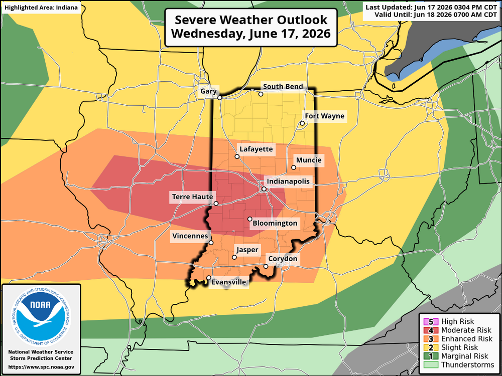
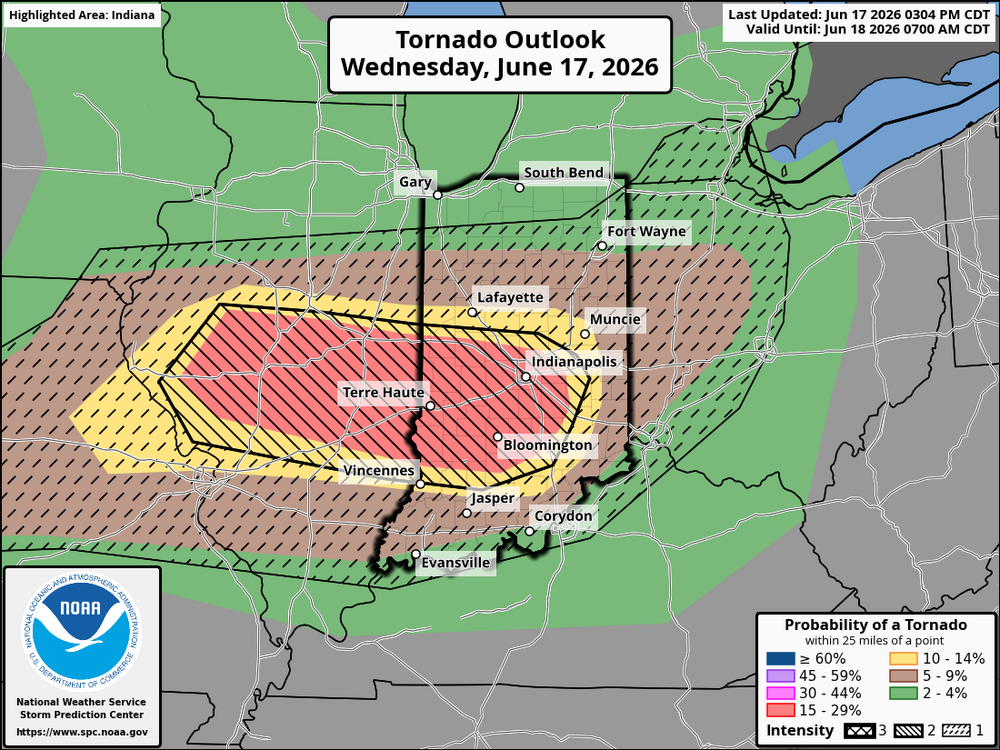
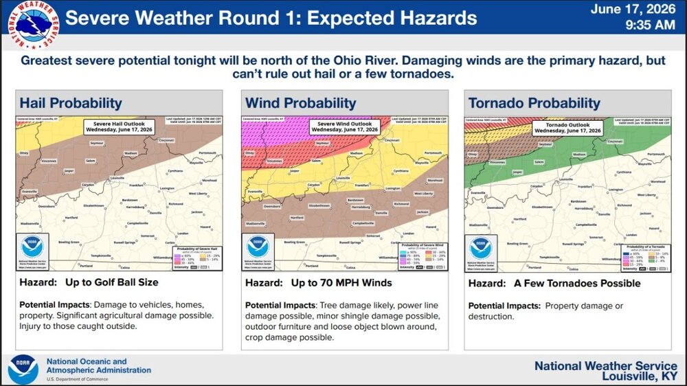
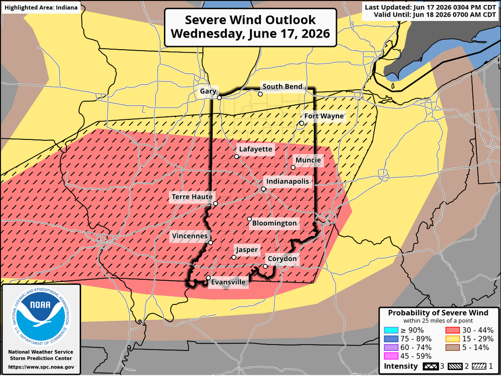 A strong area of low pressure and a slow-moving cold front will bring severe storm chances late tonight into early Thursday morning. Damaging winds and a few tornadoes are possible. Greatest Severe Potential: north of the Ohio River and I-71. Expecting to see a line of thunderstorms approach southern IN from the north late tonight. Coverage and likelihood of storms will decrease to the south through Thu morning.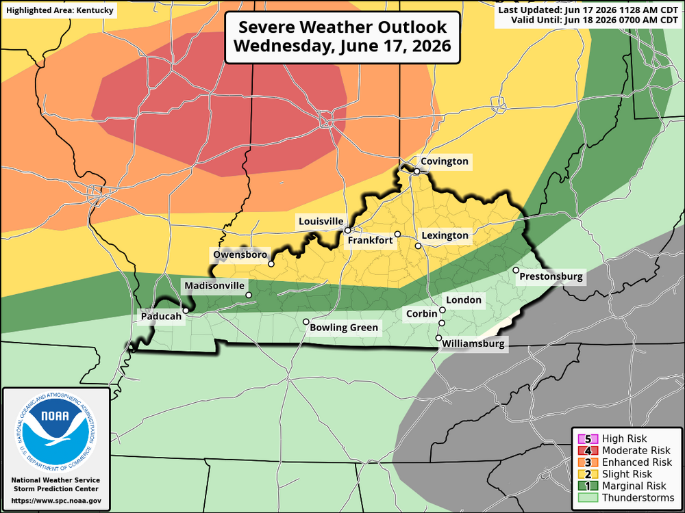
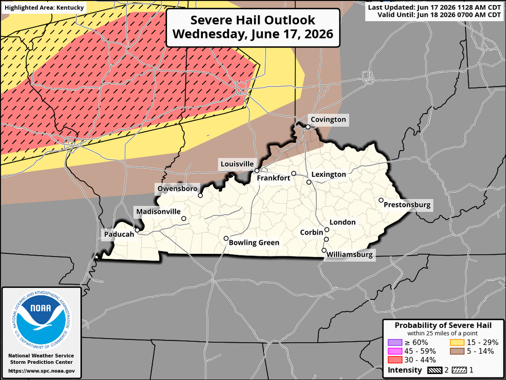
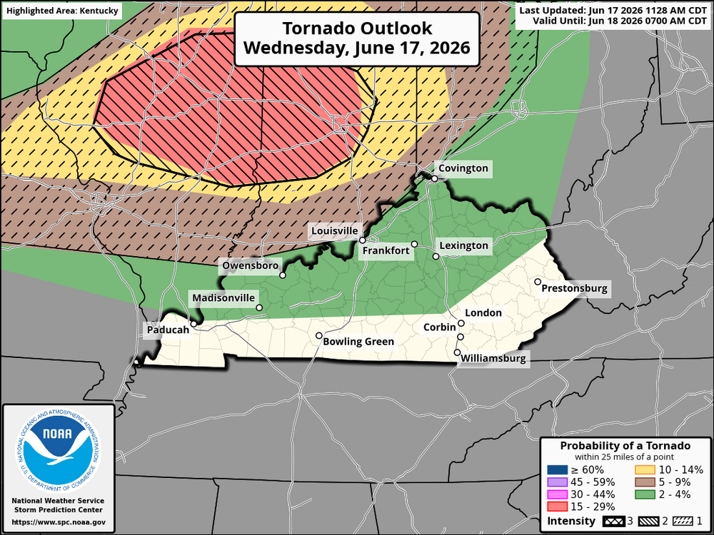
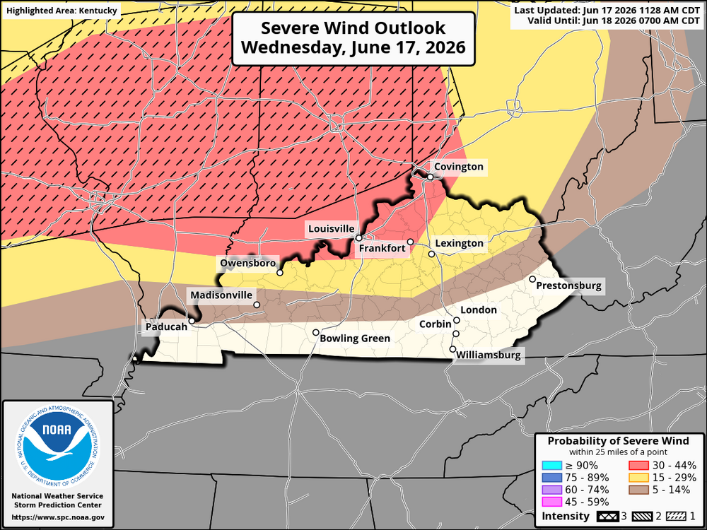 An intense line of thunderstorms is already producing damaging winds over 80 mph in the Midwest and is moving southeast. As it tracks toward Illinois and Indiana, it may influence additional storm development closer to the region later today and this evening. The main concerns for Kentucky later today into tonight include damaging straight-line winds, large hail with stronger storms, and a conditional tornado risk if storms become surface-based. There is also the potential for rapidly developing supercells if the atmosphere recovers ahead of the system. While timing and exact placement are still uncertain, the atmosphere is very favorable for severe storms, meaning any storms that form could strengthen quickly. Bottom line: stay weather-aware today, have multiple ways to receive warnings, and be ready to act quickly if watches or warnings are issued.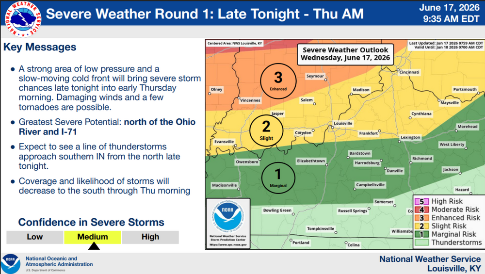






.png.d8bb9ca0a275c563bd99edcec1be1a87.png)




Account
Navigation
Search
Configure browser push notifications
Chrome (Android)
- Tap the lock icon next to the address bar.
- Tap Permissions → Notifications.
- Adjust your preference.
Chrome (Desktop)
- Click the padlock icon in the address bar.
- Select Site settings.
- Find Notifications and adjust your preference.
Safari (iOS 16.4+)
- Ensure the site is installed via Add to Home Screen.
- Open Settings App → Notifications.
- Find your app name and adjust your preference.
Safari (macOS)
- Go to Safari → Preferences.
- Click the Websites tab.
- Select Notifications in the sidebar.
- Find this website and adjust your preference.
Edge (Android)
- Tap the lock icon next to the address bar.
- Tap Permissions.
- Find Notifications and adjust your preference.
Edge (Desktop)
- Click the padlock icon in the address bar.
- Click Permissions for this site.
- Find Notifications and adjust your preference.
Firefox (Android)
- Go to Settings → Site permissions.
- Tap Notifications.
- Find this site in the list and adjust your preference.
Firefox (Desktop)
- Open Firefox Settings.
- Search for Notifications.
- Find this site in the list and adjust your preference.