.png.ffa34568722b20f38e3c3ecfcb9a2cd2.png)

.jpg.dff87640c6ed93f4bdf8eebdf96f5dec.jpg)
nWo
-
Posts
25,625 -
Joined
-
Last visited
-
Days Won
5
Everything posted by nWo
-

-
There appears to be a growing serious hazard, particularly for those living along the Ohio River. From late this afternoon into the evening and tonight, there is a chance of scattered strong to severe thunderstorms, which can produce huge hail up to two inches in diameter, destructive gusts, and a few tornadoes. These thunderstorms can occur in areas ranging from the mid-Mississippi Valley to the Ohio Valley and the southern Great Lakes. The weather will lead to isolated to dispersed storm development, probably in a somewhat bimodal fashion with a relative minimum in between. The storm will first form over the northern Illinois region and then move farther south, closer to the Ohio Valley. The Midwest and Ohio Valley regions should eventually see the emergence of more widespread storms by mid-to-late evening. These storms will then proceed eastward across the Upper Ohio Valley and toward the central Appalachians until the conclusion of the period.
-
From the mid-Mississippi Valley to the Ohio Valley and the southern Great Lakes, there will be a chance of isolated strong to severe thunderstorms that could produce huge hail up to two inches in diameter, destructive gusts, and a few tornadoes later this afternoon and overnight. There may be isolated to widely dispersed thunderstorm activity early in the forecast period. The storm's mode and coverage are still mostly unknown; some data point to more isolated development forward of the line, while other data primarily depict linear expansion along the front. Still, these storms should continue eastward into southern Indiana, northern Kentucky, and southwestern Ohio during the course of the night, with the possibility of hail and strong gusts.
-
As we prepare for the 50th Anniversary of the April 3 1974 Super Outbreak, we'd like to share your story. We'd like to make at least one video telling the stories of those who lived through it. If you want to participate please email us nws.louisville@noaa.gov or message us here on Facebook. There we will let you know how you can help and what we are looking for. Thank you.
-
-
-
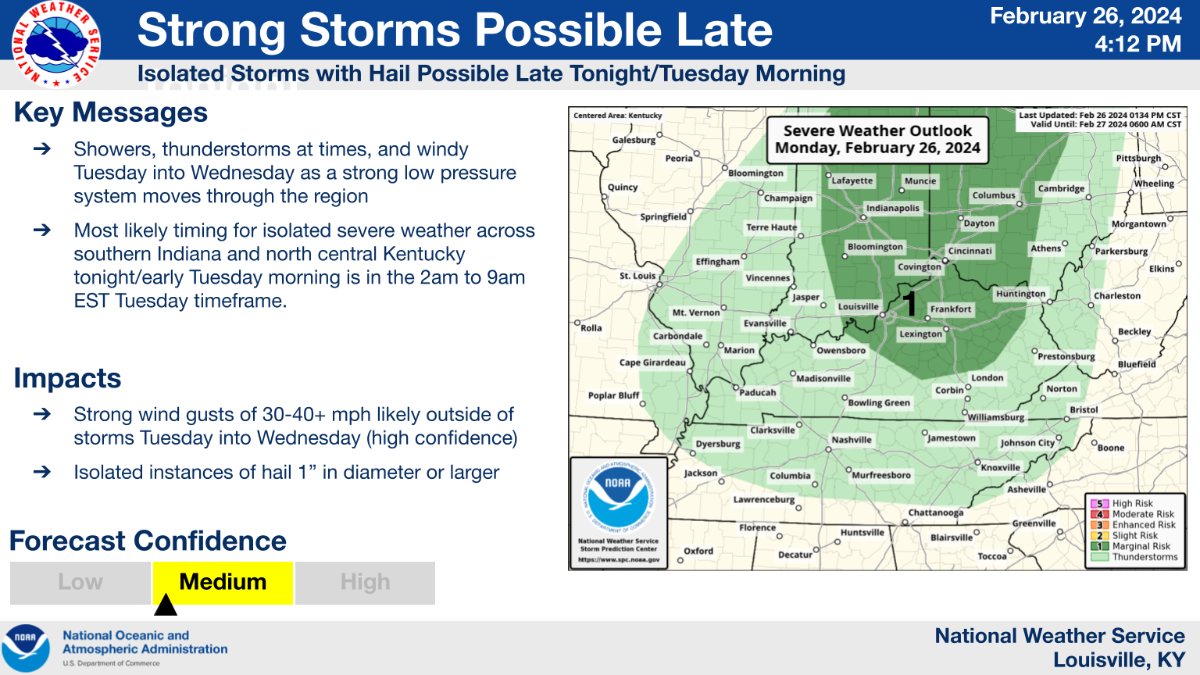
The level 1 Marginal Risk Area in Kentucky has been enlarged by the Storm Prediction Center for Tuesday night and Wednesday am.
-
-
-
On the front of severe weather this morning, there are both positive and negative updates. The risk for Kentucky has decreased, according to the Storm Prediction Center. Unfortunately, a level 1 Marginal Risk Area has been established for Tuesday late afternoon and evening. Along the Ohio River, this region stretches from western Kentucky into the Cincinnati/NKY region.
-
The most recent Storm Prediction Center maps for Wednesday and Tuesday. Extreme western Kentucky is under a level 2 Slight Risk Area on Tuesday, and the greater part of the state is under one on Wednesday.
-
Hello, I wanted to share with you what I have been observing this morning. The results of the 06z GFS run are beginning to worry me a little. It was a positive tilt at the trough when I initially began monitoring the period for the potential severe weather event. As a result, it is probable that the potential storms were not as powerful as the data now suggests. The trough is now appearing to be approaching a negative phase. This indicates an intensification of the system that is expected to produce severe weather on Tuesday and Wednesday. Indicators of more severe weather include a negative tilt trough. The first map is 500 mb Height Anomaly. It shows trough at around 18,000 ft. You can see a negative tilt. The following shows the winds at the same height as the trough. You can easily see the storm gaining strength as the counterclockwise rotation at the bottom of the trough indicates At 5,000 feet on the 850 mb Height, the winds close to the surface are from the southwest. Additionally, the winds on the map above begin in the west and move to the southwest. The varying winds at different heights might cause the storms to rotate, which would make them more likely to produce tornadoes. Wind damage, and perhaps a few tornadoes would be possible with supercells and/or the stronger bowing line segments. Also, with the Storm Prediction Center already issuing a 15% Slight Risk Area, this adds to my concern.
-
A little while ago, the National Weather Service Louisville office sent me the following information:
-
I must first correct something. In my post from last night, I posted about the wrong days. Tuesday and Wednesday were the correct dates. Next week promises to bring some extreme temperature changes. Most of Kentucky could see temperatures in the mid-to-upper 60s on Tuesday afternoon. It appears that temperatures in Western Kentucky will be in the mid- to upper-60s. Some low seventies might exist. In the western portion of the state, dewpoints may reach the low to mid-60s. This could be fuel for the possible strong to severe storms. Before a cold front, the conditions may be conducive to the formation of strong to severe storms. As of right now, Tuesday night through Wednesday early is the timetable. As the cold front passes through, Wednesday's daytime highs will fall into the low to mid-40s. Western Kentucky is currently 15% at risk of strong to severe storms on Tuesday, according to the Storm Prediction Center. On Wednesday, a 15% chance covers the majority of the remaining portion of Kentucky.
-
For Wednesday and Thursday of next week, the Storm Prediction Center has already issued a 15% severe weather outlook for most of Kentucky. The fact that they sent out one seven days in advance might hint at something important. I will post an update in the morning.
-
By mid-next week, a system I am following might have an impact on Kentucky. Over the Iowa/Missouri line, an upper-level low is predicted. It will traverse the Great Lakes Region as it moves northeast. Strong to severe storms might develop in Kentucky late on Tuesday night and early on Wednesday morning due to a trailing cold front. This far in advance, the time is not accurate. All I wanted to do was give everyone a brief overview of it. It appears that temperatures will be in the low to mid-60s ahead of the front. Temperatures will be in the high 40s, as we will see a 15-degree drop in temperature after the front moves through. Dewpoints will be in the 60s for western Kentucky and the mid-50s for most of the rest of Kentucky before the front passes. As everyone is aware, this will just serve to intensify the storms. Western Kentucky is currently the primary region of concern at the beginning of the period. As we approach and the models have a more accurate understanding of the circumstances, things will alter. The 500 mb Height Anomaly map shows the two air masses. The storms will build in the white area between the orange and blue colors. The EHI map indicates that there may be a chance for severe weather to develop.
-
It is still forecast to get 1-3 inches in your area before it is all done. Heavier snowfall is to the northwest of your area and should move in in about an hour or so. It all depends on the snowfall rate and whether it will accumulate on the ground.
-
I just wanted to check in with everyone. For those in the Cincinnati/NKY area, the snow may begin to interfere with rush hour this evening. In general, locations that receive any snowfall can anticipate 1-3" of snowfall.
-
-
Initial alert regarding potential snow accumulation. One could expect a general 1-3".
-
INZ073>075-080-KYZ089>100-OHZ073-074-077>082-088-161615- /O.NEW.KILN.WW.Y.0006.240216T1700Z-240217T0600Z/ Ripley-Dearborn-Ohio-Switzerland-Carroll-Gallatin-Boone-Kenton- Campbell-Owen-Grant-Pendleton-Bracken-Robertson-Mason-Lewis-Ross- Hocking-Hamilton-Clermont-Brown-Highland-Adams-Pike-Scioto- Including the cities of Batesville, Milan, Versailles, Osgood, Bright, Lawrenceburg, Hidden Valley, Greendale, Aurora, Dillsboro, Rising Sun, Vevay, Carrollton, Warsaw, Florence, Burlington, Oakbrook, Covington, Erlanger, Independence, Newport, Fort Thomas, Highland Heights, Bellevue, Dayton, Alexandria, Owenton, Williamstown, Crittenden, Dry Ridge, Falmouth, Butler, Augusta, Brooksville, Mount Olivet, Maysville, Tollesboro, Head Of Grassy, Camp Dix, Vanceburg, Chillicothe, Logan, Downtown Cincinnati, Milford, Summerside, Mount Carmel, Mount Repose, Withamsville, Mulberry, Day Heights, Georgetown, Mount Orab, Ripley, Aberdeen, Hillsboro, Greenfield, West Union, Manchester, Peebles, Seaman, Winchester, Waverly, Pike Lake, Piketon, Portsmouth, and Wheelersburg 308 AM EST Fri Feb 16 2024 ...WINTER WEATHER ADVISORY IN EFFECT FROM NOON TODAY TO 1 AM EST SATURDAY... * WHAT...Snow expected. Total snow accumulations of up to two inches. * WHERE...Portions of southeast Indiana, northeast and northern Kentucky and central, south central and southwest Ohio. * WHEN...From noon today to 1 AM EST Saturday. * IMPACTS...Plan on slippery road conditions. The hazardous conditions could impact the evening commute. PRECAUTIONARY/PREPAREDNESS ACTIONS... Slow down and use caution while traveling. Additional information can be found at www.weather.gov/iln as well as on our Facebook and Twitter pages.
-
-
KYZ058-068-069-088-110>118-120-162200- /O.NEW.KJKL.WW.Y.0008.240216T2100Z-240217T0900Z/ Estill-Rockcastle-Jackson-Harlan-Floyd-Lee-Breathitt-Knott-Owsley- Perry-Clay-Leslie-Letcher-Pike- Including the cities of Irvine, Ravenna, Brodhead, Mount Vernon, McKee, Annville, Cumberland, Harlan, Prestonsburg, Wheelwright, Beattyville, Jackson, Hindman, Pippa Passes, Booneville, Hazard, Manchester, Hyden, Jenkins, Whitesburg, Coal Run, Elkhorn City, Pikeville, and South Williamson 255 AM EST Fri Feb 16 2024 ...WINTER WEATHER ADVISORY IN EFFECT FROM 4 PM THIS AFTERNOON TO 4 AM EST SATURDAY... * WHAT...Snow expected. Total snow accumulations of up to two inches with the highest amounts generally in the higher elevations and northern portions of the counties with lesser amounts elsewhere. * WHERE...Portions of east central, south central and southeast Kentucky. * WHEN...From 4 PM this afternoon to 4 AM EST Saturday. * IMPACTS...Plan on slippery road conditions. The hazardous conditions could impact the evening commute. * ADDITIONAL DETAILS...A brief period of sleet will be possible as rain transitions to snow. PRECAUTIONARY/PREPAREDNESS ACTIONS... Slow down and use caution while traveling. The latest road conditions for Kentucky can be found by visiting https://goky.ky.gov.
.thumb.jpg.dc448957daf4ddf2823660190e844abb.jpg)


.png.9a252d7d3b7e8a0a75a45a9b8ba4343a.png)
.png.d02243fc49479d0be069d333b5c20ded.png)


.png.6f86e645658d555916a6d76311662b94.png)

.png.10b57509ca9c5ef07ff738d934cac054.png)

.png.0ad003acc29e75549d6be46c5ee87111.png)