

nWo
BGP Meteorologist
-
Joined
-
Last visited
Everything posted by nWo
-
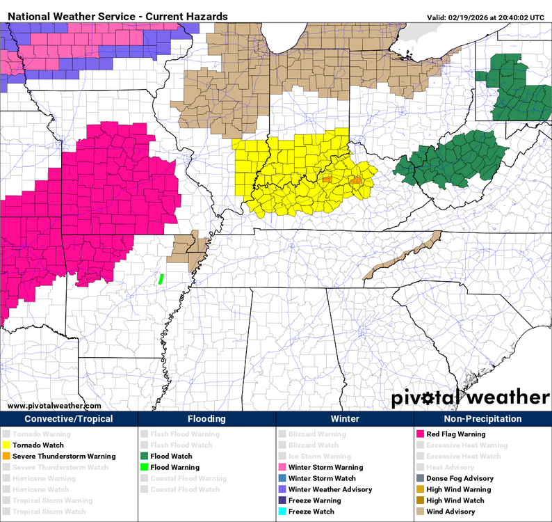
The watch area has been expanded. WATCH COUNTY NOTIFICATION FOR WATCH 10 NATIONAL WEATHER SERVICE LOUISVILLE KY 318 PM EST THU FEB 19 2026 KYC017-049-067-079-097-113-151-181-209-239-200200- /O.EXA.KLMK.TO.A.0010.000000T0000Z-260220T0200Z/ THE NATIONAL WEATHER SERVICE HAS EXTENDED TORNADO WATCH 10 TO INCLUDE THE FOLLOWING AREAS UNTIL 9 PM EST THIS EVENING IN KENTUCKY THIS WATCH INCLUDES 10 COUNTIES IN CENTRAL KENTUCKY BOURBON CLARK FAYETTE GARRARD HARRISON JESSAMINE MADISON NICHOLAS SCOTT WOODFORD THIS INCLUDES THE CITIES OF BEREA, BRECKINRIDGE, BRYANTSVILLE, BUCKEYE, CARLISLE, CLINTONVILLE, COLVILLE, CYNTHIANA, DUCKERS, FORD, GEORGETOWN, HIGH BRIDGE, HOOKTOWN, KEENE, KINGSTON, KIRKSVILLE, LANCASTER, LEESBURG, LEXINGTON, LOWELL, MCCREARY, MILLVILLE, MYERS, NEW ZION, NEWTOWN, NICHOLASVILLE, ODDVILLE, OXFORD, PAINT LICK, PARIS, REDHOUSE, RICHMOND, RUCKERVILLE, VALLEY VIEW, VERSAILLES, WILMORE, AND WINCHESTER.
-
This morning, I suppose, was a good day to recertify my NWS-Louisville spotter training.
-
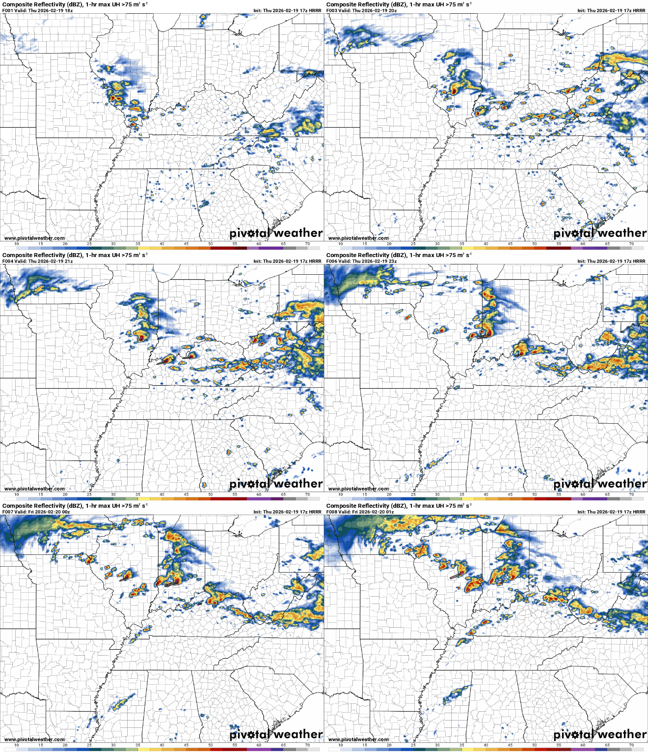
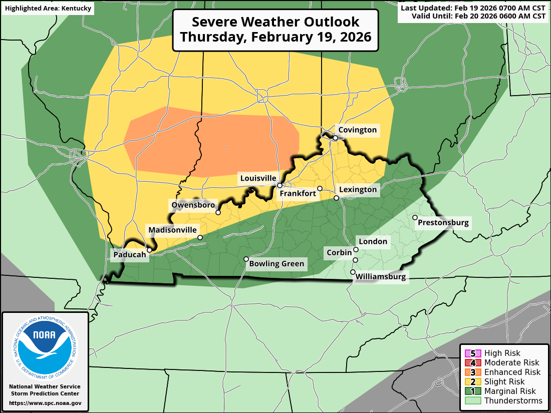
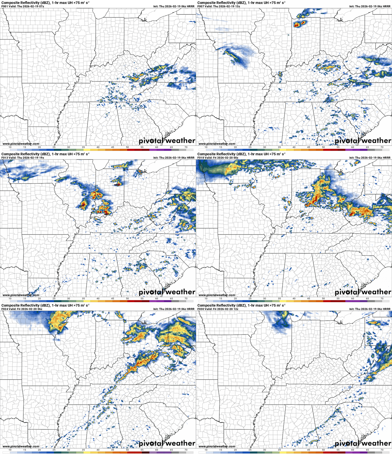
These individual cells could become a supercell storm that could produce all severe weather modes. Everyone in the affected area should be planning what to do in case a severe weather warning is issued for your area. This map covers the time the tornado watch is in effect.
-
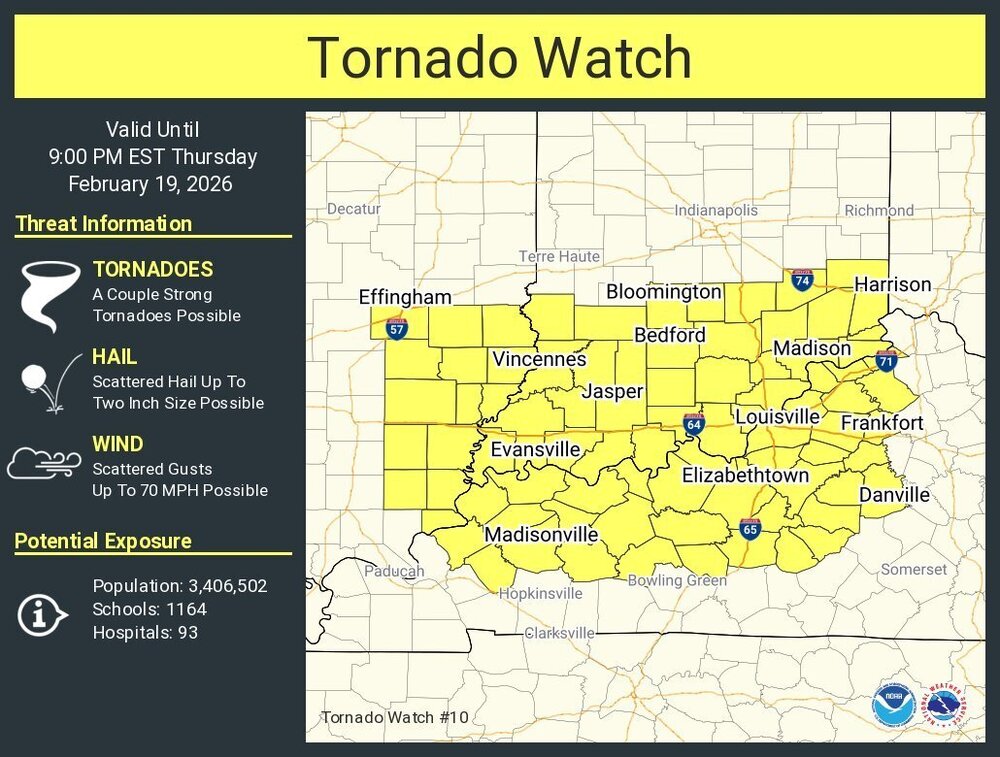
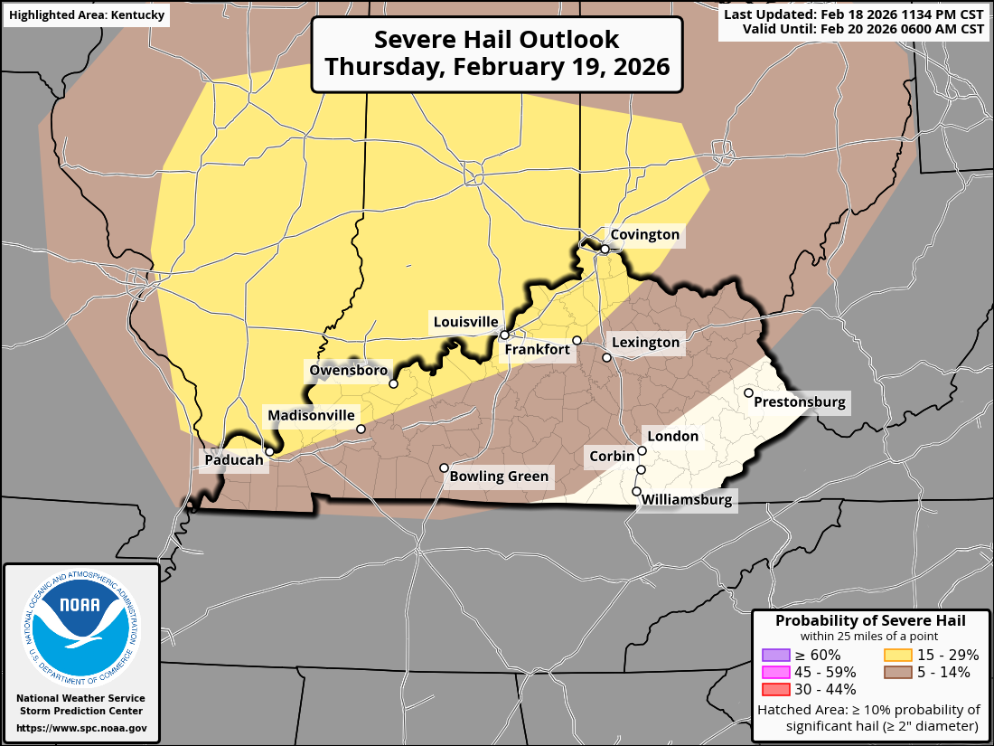
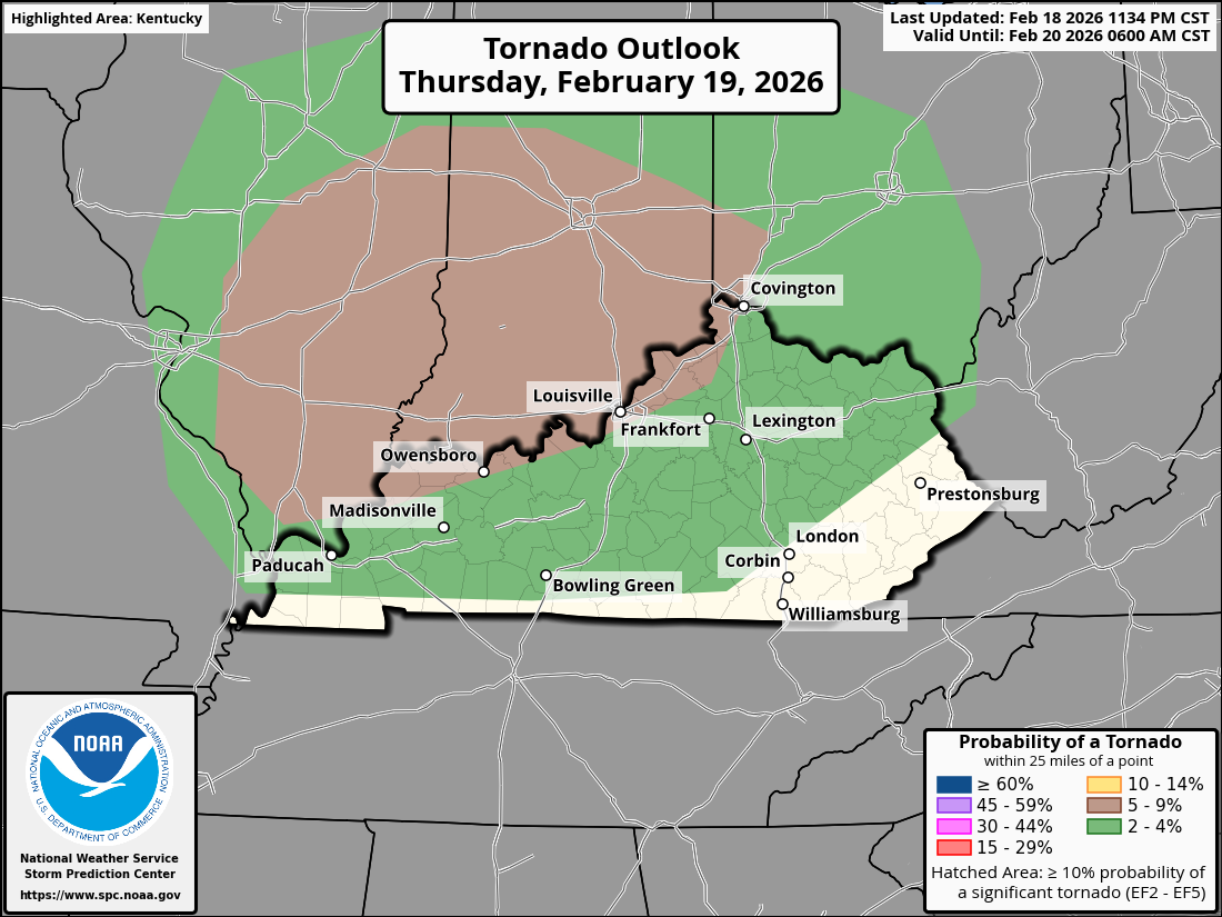
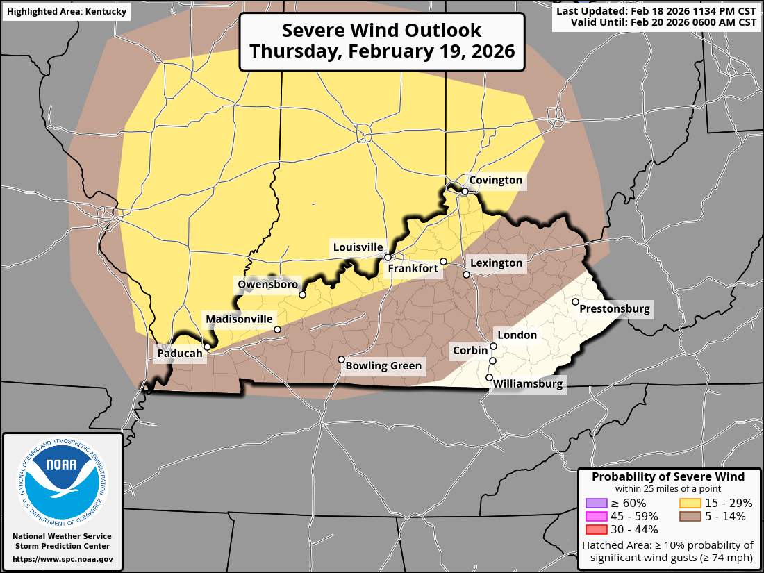
URGENT - IMMEDIATE BROADCAST REQUESTED Tornado Watch Number 10 NWS Storm Prediction Center Norman OK 115 PM EST Thu Feb 19 2026 The NWS Storm Prediction Center has issued a * Tornado Watch for portions of Southeast Illinois Southern Indiana Western and Central Kentucky * Effective this Thursday afternoon and evening from 115 PM until 900 PM EST. * Primary threats include... A few tornadoes and a couple intense tornadoes possible Scattered large hail and isolated very large hail events to 2 inches in diameter possible Scattered damaging wind gusts to 70 mph possible SUMMARY...Thunderstorm development is anticipated this afternoon from southeast Illinois into southern Indiana and western/central Kentucky. In these areas, increasing low-level moisture will lead to airmass destabilization. Strong vertical shear is in place, supporting the potential for some of these storms to organize into supercells. All severe hazards are possible with any supercells that develop, including very large hail greater than 2" in diameter and tornadoes. Low-level shear is strong enough to support the potential for a strong (EF2+) tornado. The tornado watch area is approximately along and 75 statute miles north and south of a line from 50 miles west of Evansville IN to 50 miles east northeast of Louisville KY. For a complete depiction of the watch see the associated watch outline update (WOUS64 KWNS WOU0). PRECAUTIONARY/PREPAREDNESS ACTIONS... REMEMBER...A Tornado Watch means conditions are favorable for tornadoes and severe thunderstorms in and close to the watch area. Persons in these areas should be on the lookout for threatening weather conditions and listen for later statements and possible warnings. @theguru
-
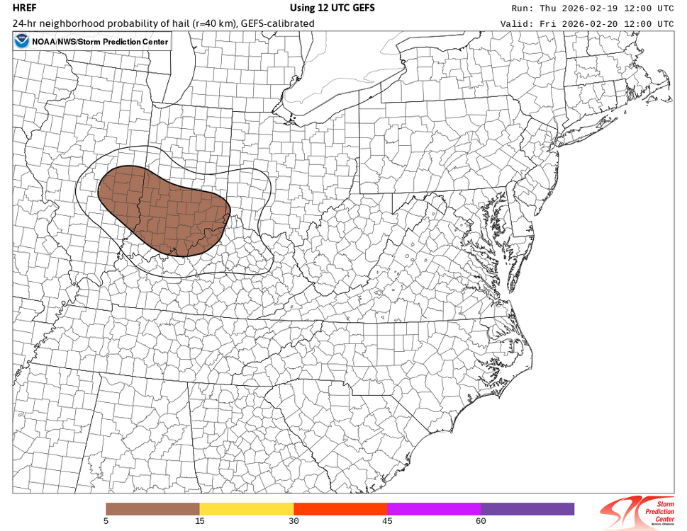
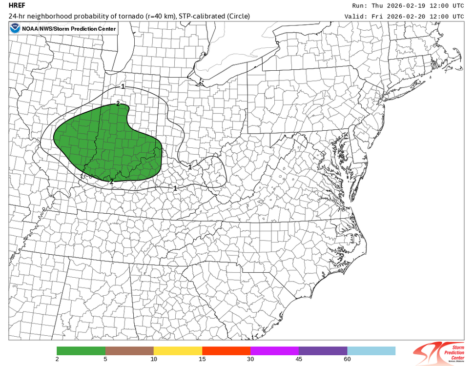
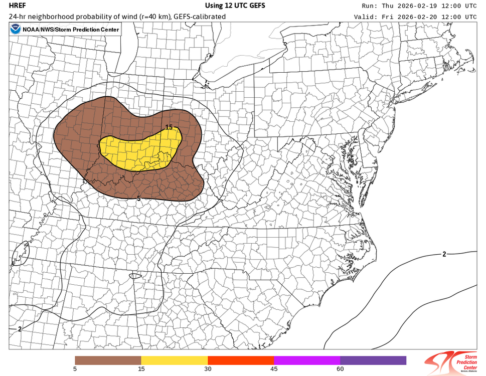
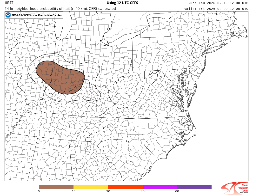
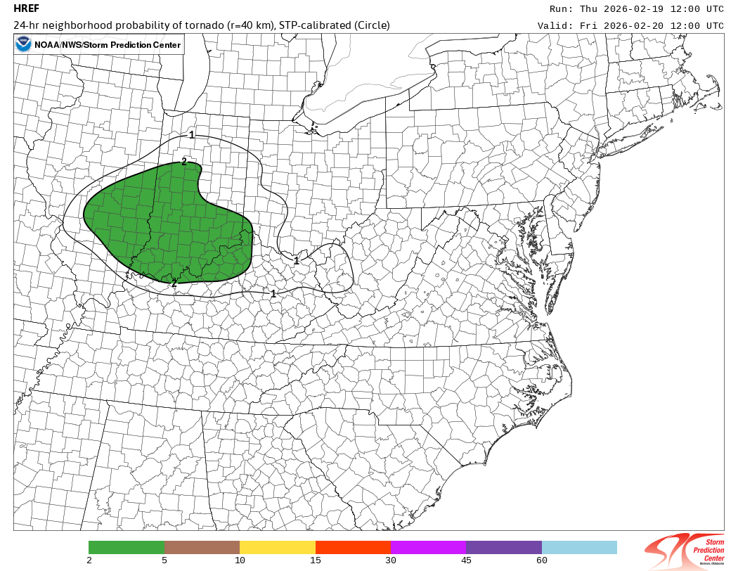
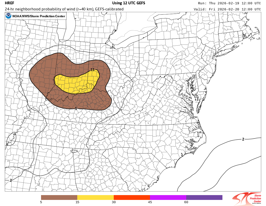
The tornado and hail threat has increased for those in the area confined north of I-64 and west of I-75.
-
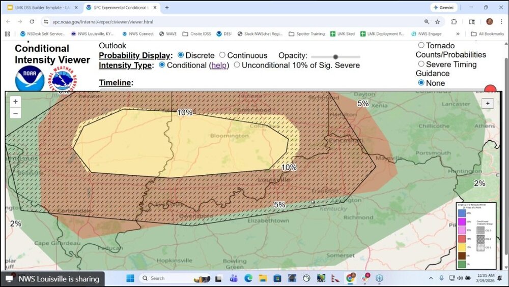
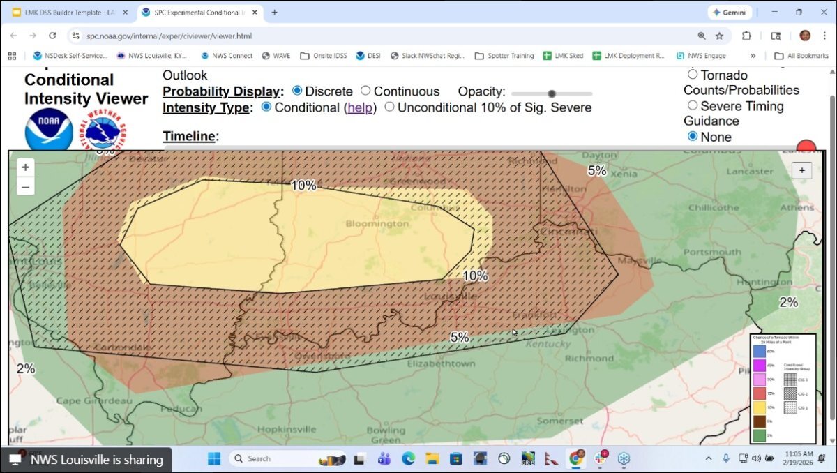
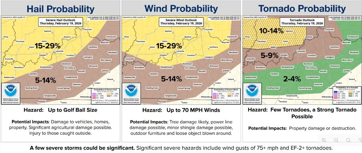
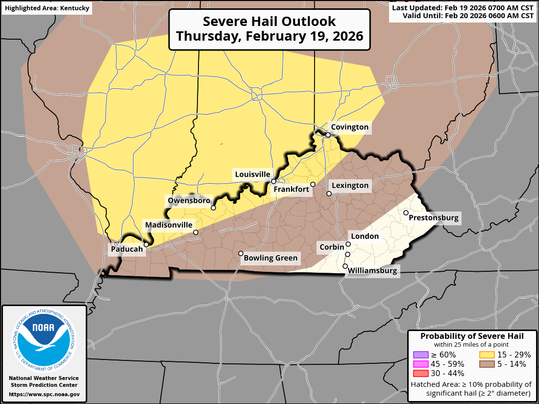
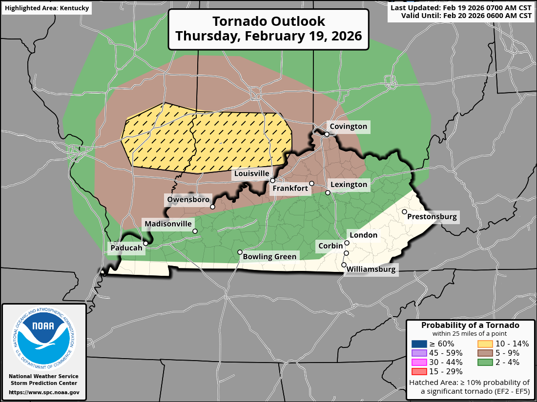
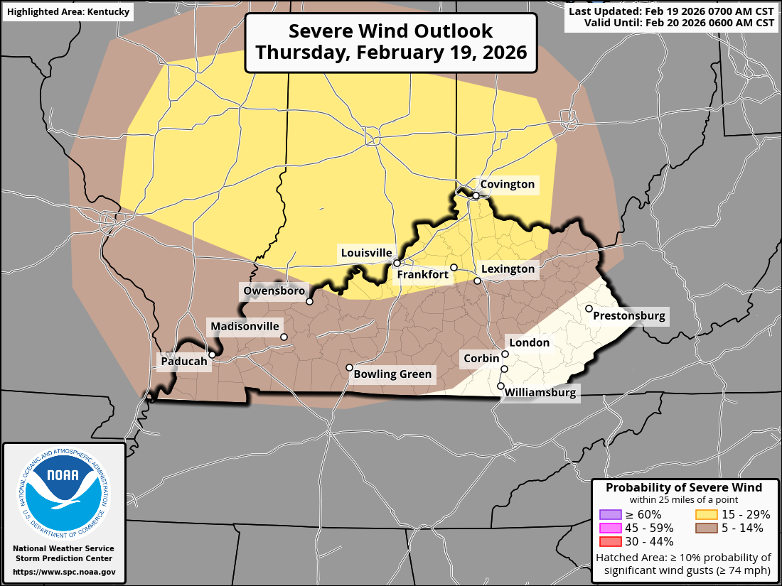
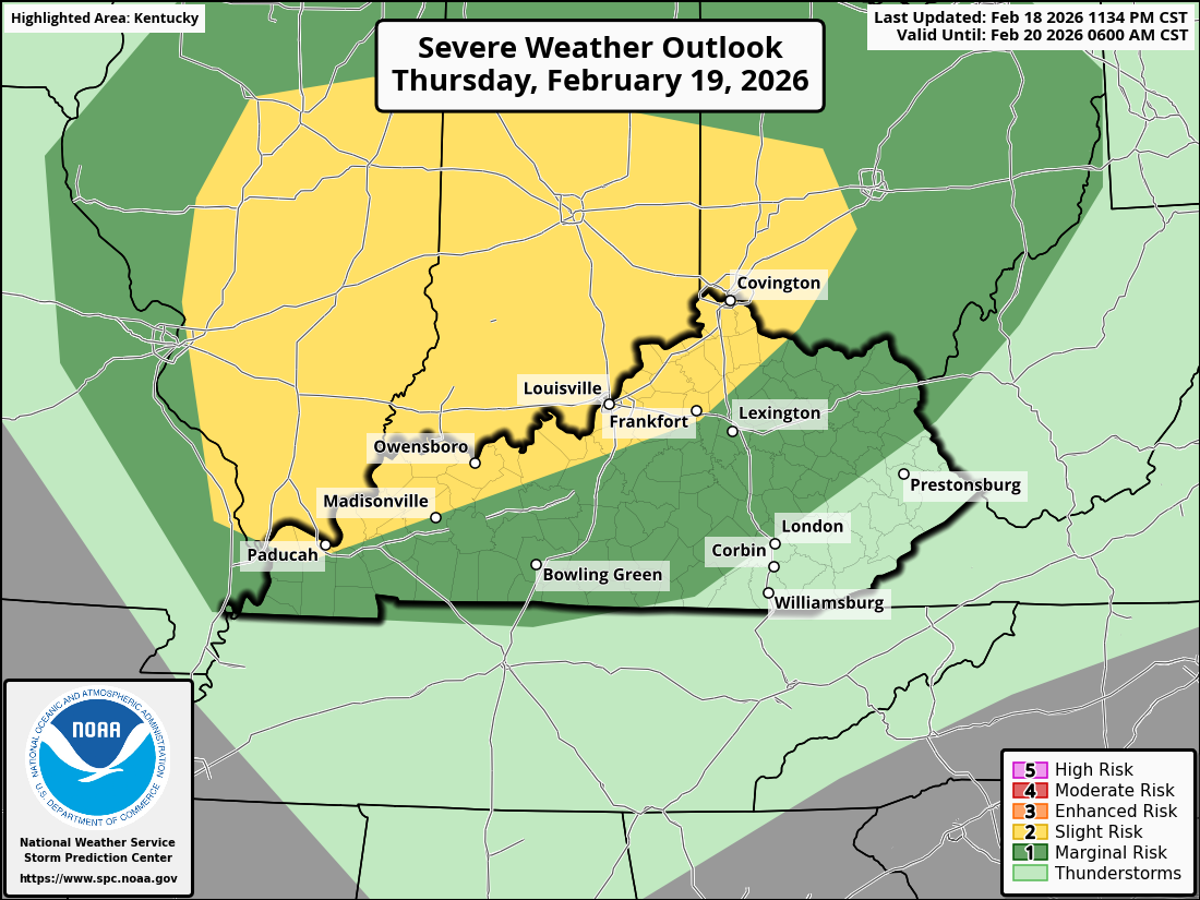
from the conference call. Tornadoes of EF-2 to EF3 intensity and destructive wind gusts of 75 mph or more are likely to be seen by those in the yellow. The worst-case scenario for potential tornado formation is represented by the enlarged hatched area. Therefore, residents of the hatched area should remain vigilant. Those near the Ohio River should also be on the lookout. The conference call host stated that he anticipates the level 3 enhanced area to be extended in the direction of Kentucky.
-
I just received notification of a conference call with the NWS-Louisville office at 11 am EST.The severe threat has increased; The forecast for Kentucky and Cincinnati today calls for increasingly severe weather through the day, with the highest risk in the afternoon and early evening. There will be a significant tornado threat, especially in areas south of I-70 and near I-64 (southern Illinois, southern Indiana). While Kentucky is on the periphery of the highest threat, there is still a notable risk of tornado development, particularly in northern Kentucky. Tornadoes could be strong (EF2+), and several tornadoes may occur, particularly in the afternoon and early evening hours. Strong, gusty winds up to 60-70 mph are also possible with thunderstorms. Large hail (up to 2 inches in diameter) will be a secondary concern but still possible. Storms will begin to intensify in eastern Missouri by late morning and will reach Kentucky and Cincinnati by mid- to late afternoon. Southern Illinois and southern Indiana will see the first round of severe storms, followed by increasing risk for areas of northern Kentucky and southwestern Ohio by late afternoon and evening. Expect discrete supercells to form near the I-70 corridor, and these storms may move into northern Kentucky and the Cincinnati metro area. These supercells could last for several hours. The severe risk for the Kentucky and Cincinnati area will likely peak from early afternoon to early evening. The primary risk will be tornadoes, damaging winds, and large hail, especially in Kentucky north of I-64, but other areas should also stay alert. As the evening progresses, storm intensity may decrease slightly. Temperatures will be in the mid-50s to low 60s°F, with surface dewpoints in the low to mid-50s°F. The low-level moisture feeding into the warm sector will enhance storm development later in the afternoon. In summary, be prepared for severe thunderstorms, including tornadoes, damaging winds, and large hail, especially from early afternoon to early evening.
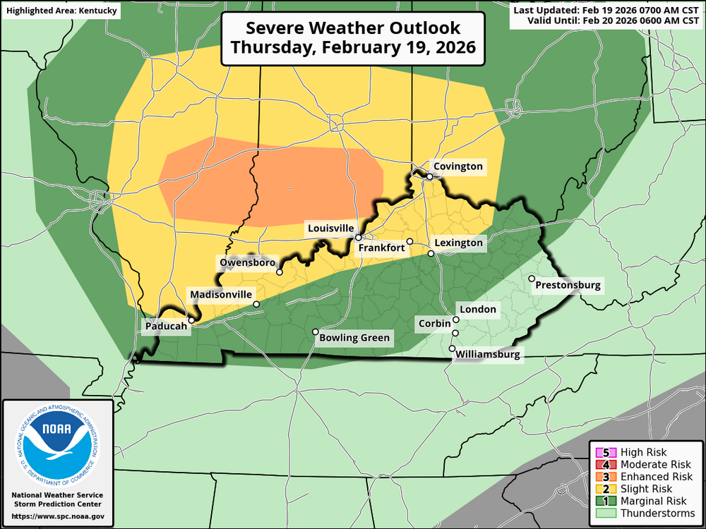
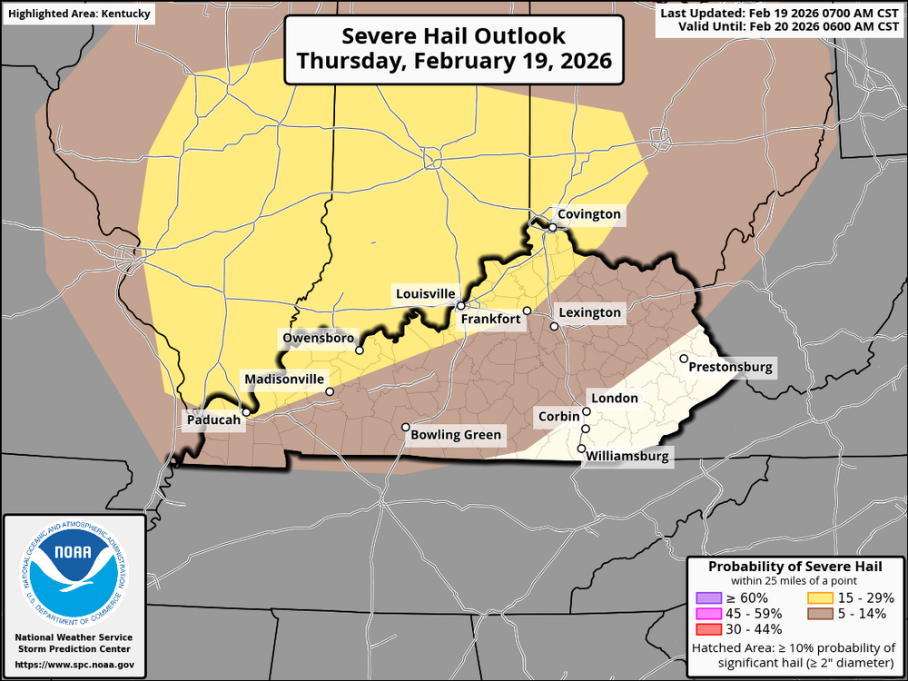
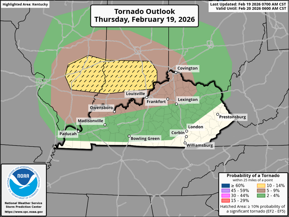
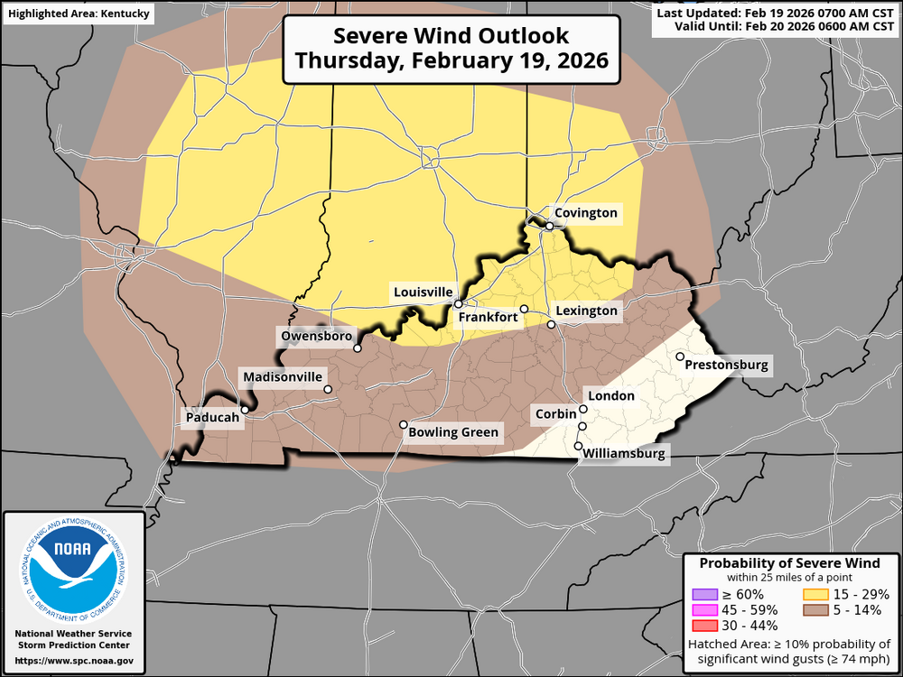 The severe weather, including potential tornadoes, large hail, and damaging winds, will primarily impact several cities in Kentucky. Some cities that may be affected include Louisville, Lexington, Frankfort, Bowling Green, Richmond, Paducah, Owensboro, Elizabethtown, Maysville, Ashland, and Morehead. These cities, particularly Louisville, Lexington, and Bowling Green, could experience the strongest storms between late morning and early afternoon. The threat of severe weather will move northeastward, so cities like Ashland and Maysville may face more significant impacts as the day progresses. The Cincinnati/NKY area will also be affected by the severe weather as it moves northeastward. The city could experience damaging wind gusts, large hail, and potentially even tornadoes as the storm system reaches Ohio later in the afternoon and evening. The strongest impacts for Cincinnati are expected between the afternoon and early evening hours. Stay aware of any watches or warnings, especially for tornadoes and damaging winds, as the storm system moves across the region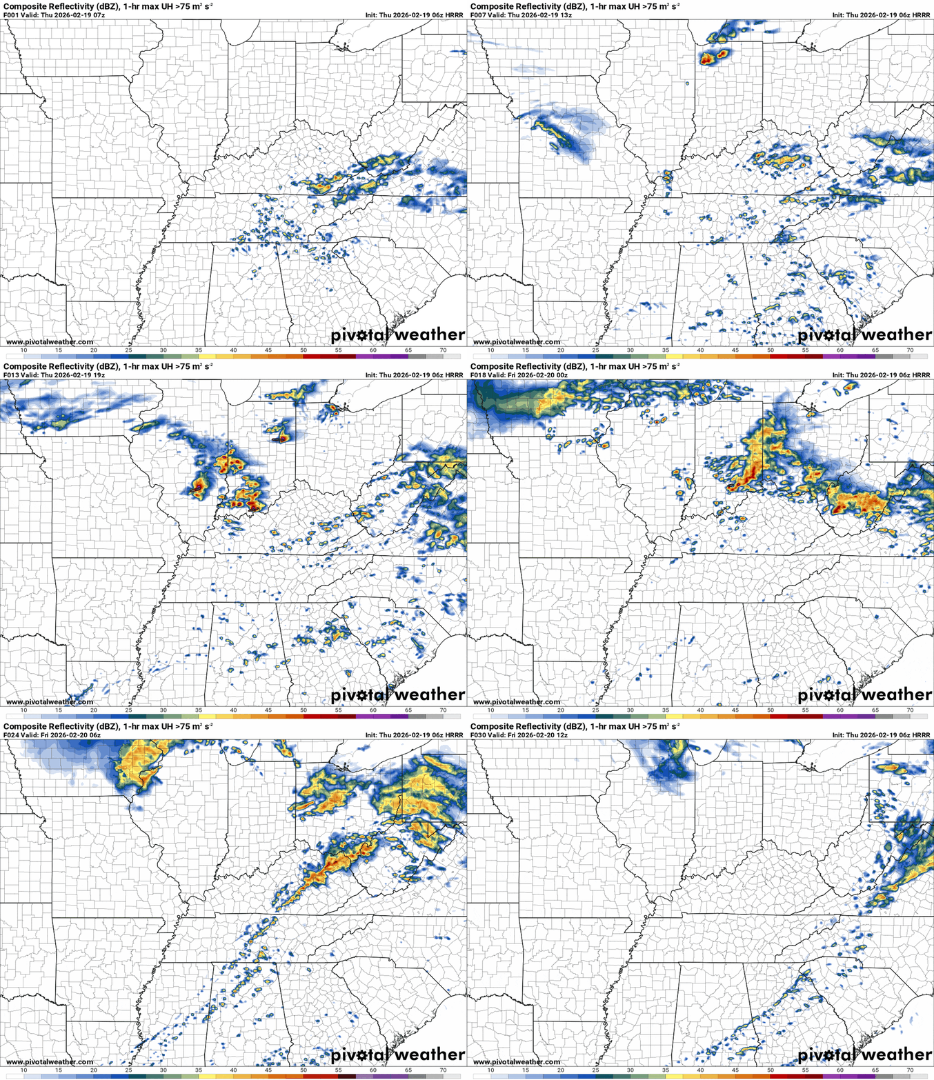
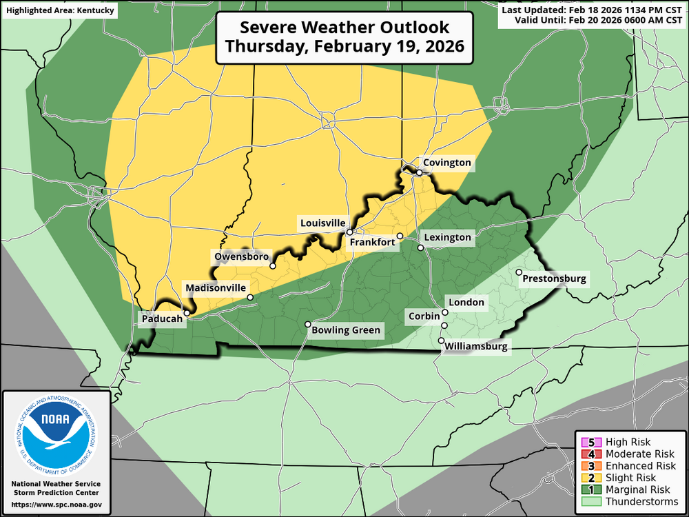
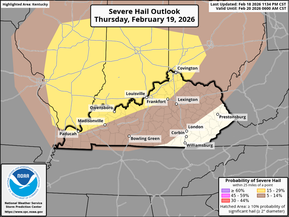
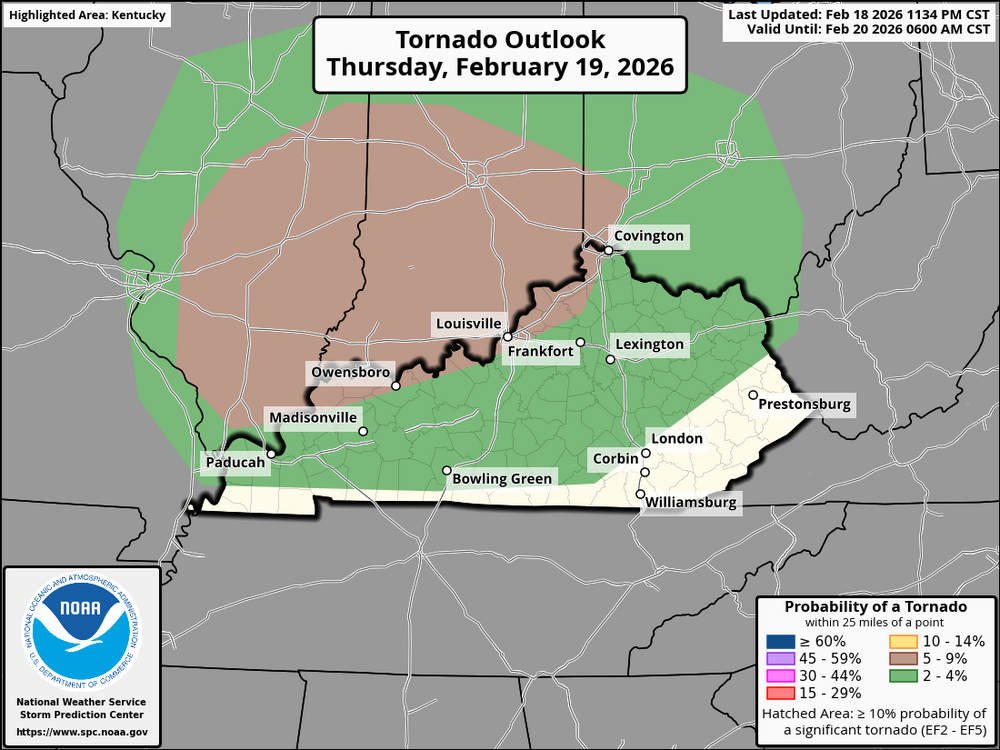
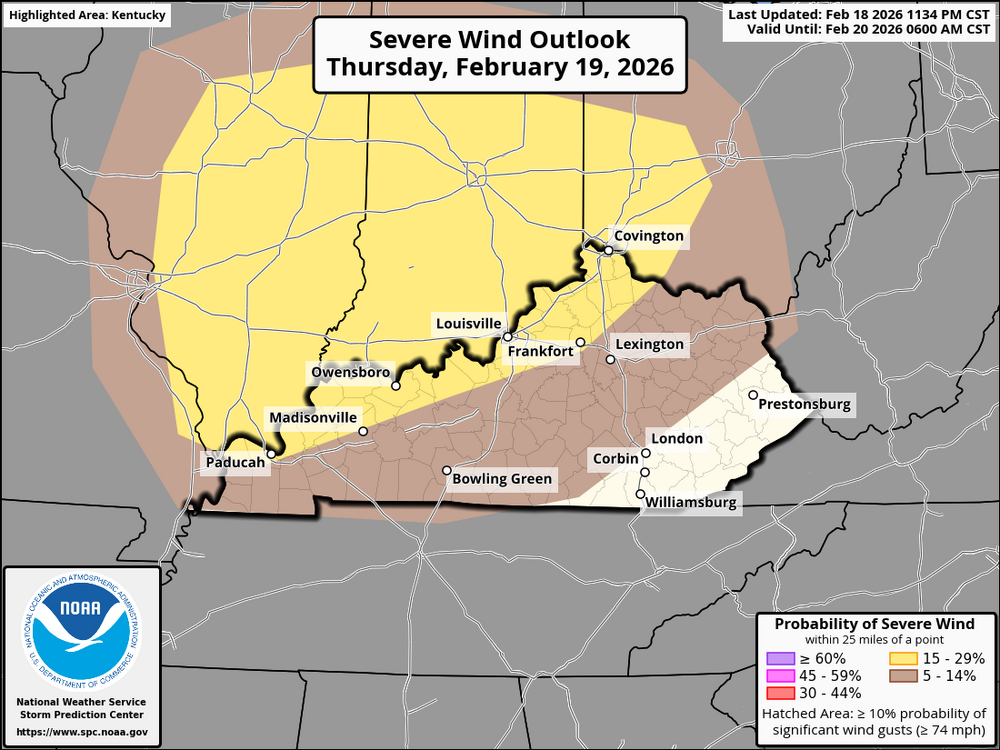 While the main focus of the storm activity is expected to be in Illinois, southeastern Indiana, and parts of Missouri, Kentucky could still be affected by the weather system. The storms are likely to move eastward through the region, so Kentucky may see some impacts later in the day, particularly in the evening. Kentucky could experience severe thunderstorms, especially in the western and central parts of the state. These storms could bring heavy rainfall, large hail, and the potential for damaging wind gusts. There's also a small possibility of tornadoes, particularly in the strongest storms, though the risk for Kentucky is expected to be lower than in areas further west. Overall, Kentucky should stay alert, especially by late afternoon and evening, as the storm system moves eastward. The timing and severity of impacts will depend on how the storms evolve as they move into the region.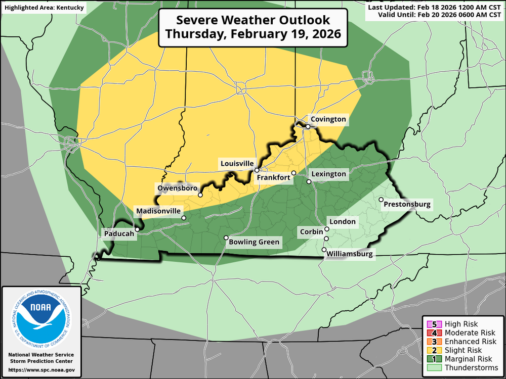
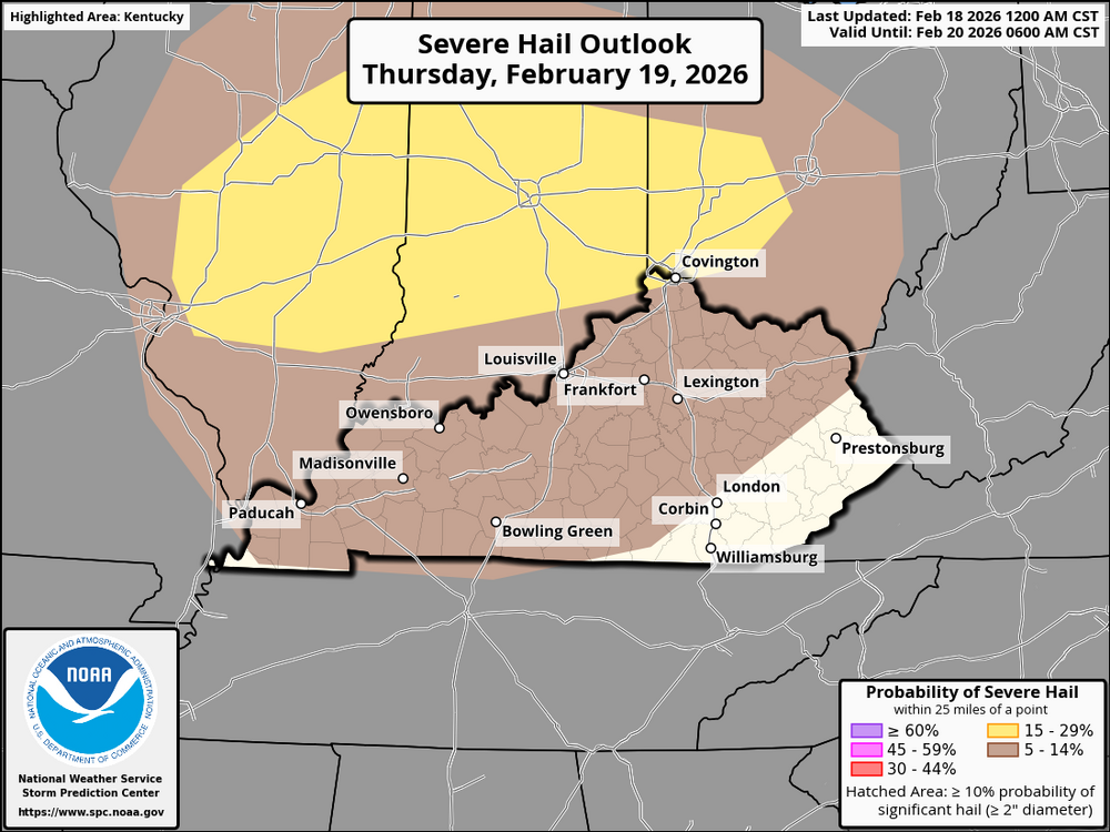
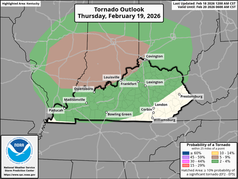
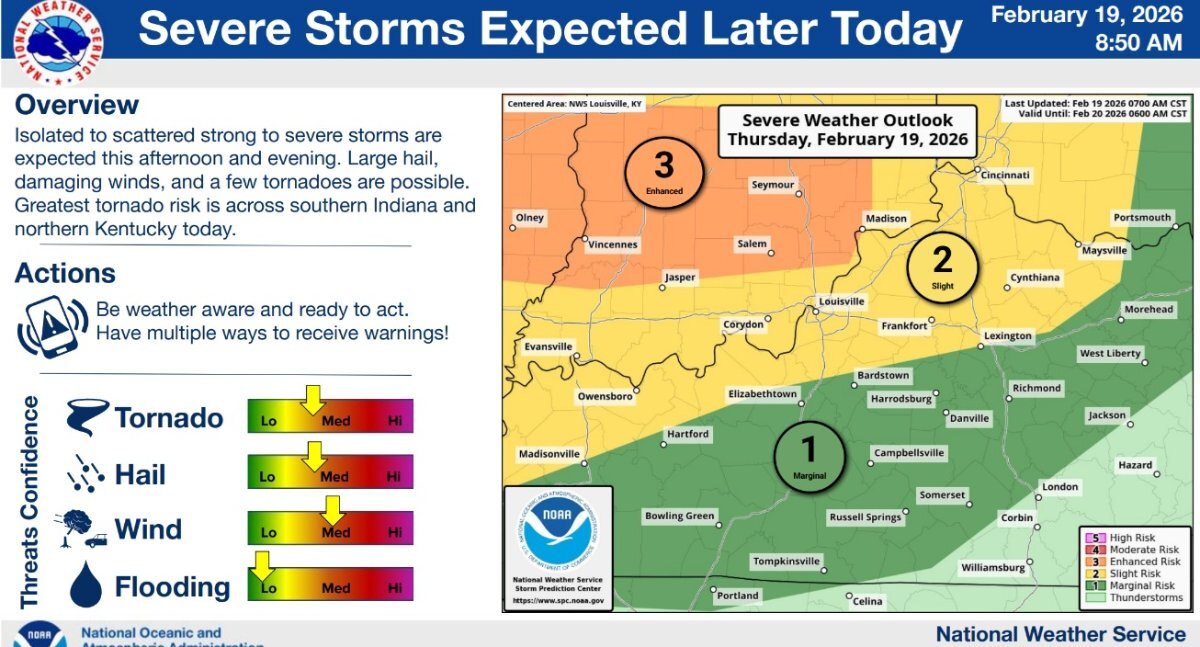
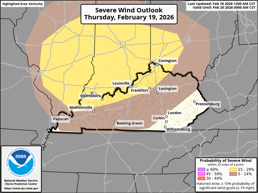 Briefing slide I just received from the NWS-Louisville office. They also stated that the most concern is for southern Indiana and north-central Kentucky for the strongest severe threat.
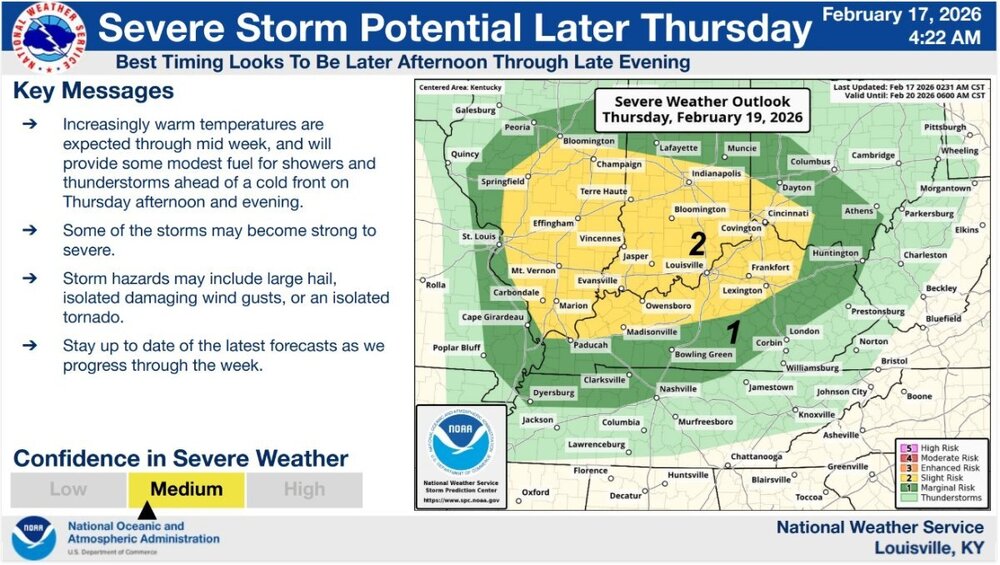 According to models, the developing storm's warm sector will see a return of moisture on Thursday afternoon, with surface dew points in the mid-50s to close to 60°F. Warmer mid- and upper-level temperatures, however, might prevent severe storms. Even though forecast soundings indicate marginal instability (CAPE of about 500 J/kg), low-topped convection may still form supercells with strong shear, which could result in small hail and tornadoes. Stronger gusts may also be brought by a small storm cluster. Keep checking back for updates!
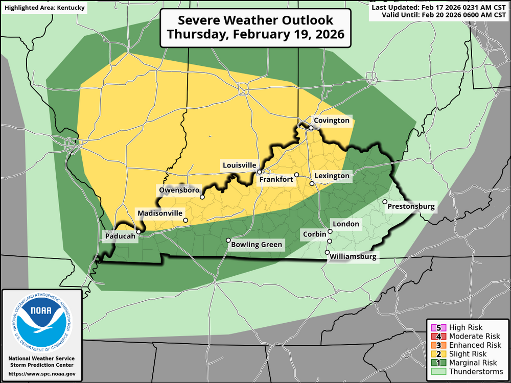 I just checked the 00z GFS run; there is a possibility of some light snow accumulations Saturday night into Sunday morning.We still are in winter, so don't be fooled by this warm stretch. We could see some more snow before spring.Strong storms will be possible Thursday afternoon/early evening. This doesn’t appear to be a widespread event, but everyone should be alert. The potential will exist for possible supercell thunderstorms that could produce tornadoes. Perhaps the most notable is that the latest model output appears a bit more aggressive than last evening's run concerning a corridor of warm sector moisture return to the area of the Mississippi and Ohio Rivers. It now appears that this may include surface dew points increasing as high as the upper 50s to lower 60s by around 3 pm to 7 pm EST. Which may move east-northeastward through the lower Ohio Valley before being cut off later Thursday evening. Though still somewhat modest, and perhaps only supportive of CAPE on the order of 500 J/kg, this probably will be conducive to severe thunderstorm development. This may include supercells with the potential to produce tornadoes and perhaps an upscale growing cluster with strong to severe gusts for a period Thursday evening. The picture shows the setup as of now. There will exist a broad positively tilted trough (black arrow on the left). Most of the winds and the jet streak will have passed the axis of the trough. This will limit somewhat the potential for a severe weather outbreak. The blue circle shows diffluence aloft. This is shown by the black isobar lines spreading apart. This means the winds are spreading apart. When this happens, the atmosphere likes to balance itself out and replace the winds by drawing air and moisture from the surface. These will be the ingredients for strong to severe storms. The bold black arrows show ridges in the trough, and this will be the trigger for storms to develop. The yellow circle shows where I think the best chance for storms will exist. Keep checking Bluegrasspreps for updates.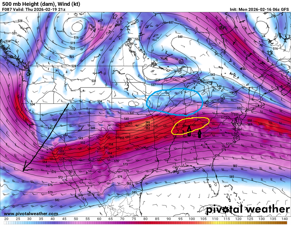
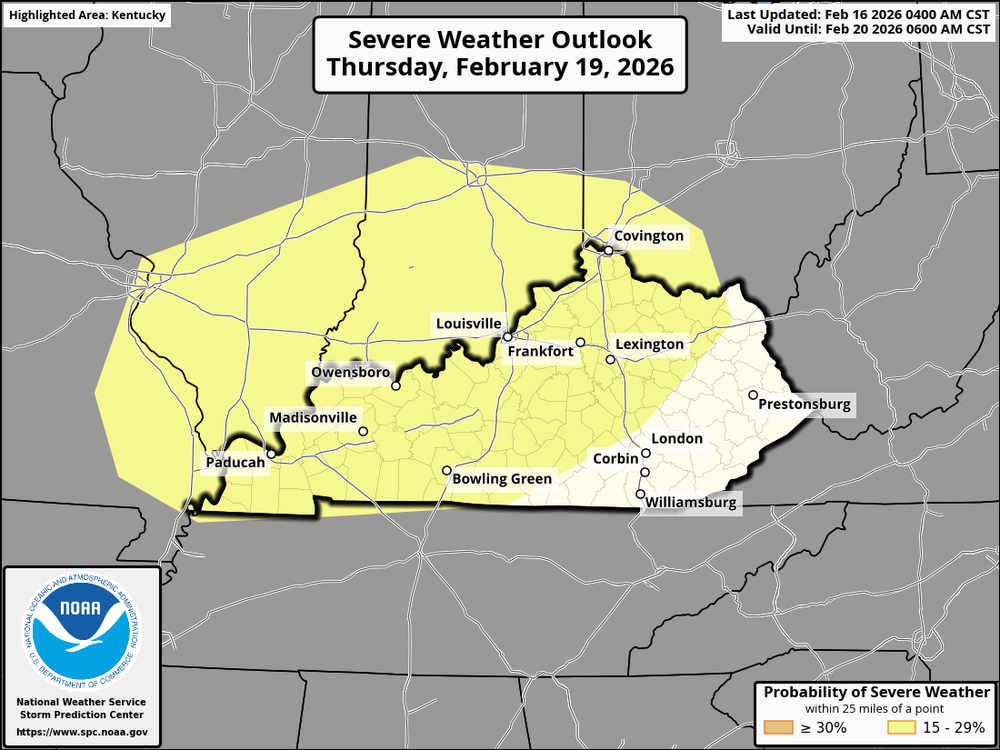 Here's what to expect over the next 6-10 days: Temperature Outlook: Kentucky will likely experience warmer-than-normal temperatures during this period, with above-average temperatures in much of the central U.S. This could lead to some spring-like warmth in the region but also raise the potential for severe thunderstorms. Precipitation Outlook: The forecast calls for above-normal precipitation, meaning rain could be frequent, especially in the latter part of the period. With these systems, there is an increased likelihood of severe weather, including strong winds, hail, and possibly tornadoes. Severe Weather Risks: (There are no severe storms in the forecast as of now.) Strong thunderstorms and severe wind gusts are possible, particularly if a cold front or low-pressure system moves through Kentucky. Stay alert for potential severe storms in the later part of February. Stay Safe: Monitor local weather forecasts frequently. Have a severe weather plan in place, and make sure you're set up to receive weather alerts. Stay tuned to Bluegrasspreps for the latest weather updates and information.Near-normal temperatures and above-normal precipitation are forecast for Kentucky as Valentine's Weekend draws near. What's planned for the upcoming days is as follows: Temperatures: Near-normal temperatures across the state, with highs in the 40s-50s and lows in the 20s-30s. Expect typical February weather—not too warm, not too cold. Precipitation: Above-normal rainfall is likely, with some rainy days ahead. As the surface low moves across the region, there’s a possibility of snow over the Valentine's weekend. The chance of snow looks low, but it's something to watch as temperatures drop—especially in the northwest and higher elevations. Possible Snow? Snow isn’t a guarantee, but colder air could bring a light dusting of snow, especially over the weekend. As we approach, I will revise the forecasts to include more information! Get ready for wet conditions and the chance for some snowflakes over the Valentine's weekend. Stay safe.this has been canceledURGENT - WEATHER MESSAGE National Weather Service Wilmington OH 1215 PM EST Fri Feb 6 2026 INZ058-059-066-073>075-080-KYZ089>100-OHZ070-077>079-081-088-070115- /O.EXA.KILN.CW.Y.0009.260207T0600Z-260207T1700Z/ Fayette-Union-Franklin-Ripley-Dearborn-Ohio-Switzerland-Carroll- Gallatin-Boone-Kenton-Campbell-Owen-Grant-Pendleton-Bracken- Robertson-Mason-Lewis-Butler-Hamilton-Clermont-Brown-Adams-Scioto- Including the cities of Mulberry, Camp Dix, Mount Repose, Augusta, Mount Olivet, Dillsboro, Vevay, Independence, Butler, Osgood, Liberty, Newport, Warsaw, Hamilton, Aurora, Head Of Grassy, West College Corner, Maysville, Dayton, Dry Ridge, Georgetown, Burlington, Ripley, Wheelersburg, Milan, Carrollton, Erlanger, Bright, Milford, Covington, Brookville, Batesville, Brooksville, Versailles, Downtown Cincinnati, Withamsville, Aberdeen, Vanceburg, Fort Thomas, Falmouth, West Union, Portsmouth, Bellevue, Connersville, Manchester, Lawrenceburg, Winchester, Highland Heights, Oxford, Summerside, Day Heights, Hidden Valley, Alexandria, Owenton, Mount Carmel, Mount Orab, Crittenden, Rising Sun, Tollesboro, Oakbrook, Florence, Williamstown, Seaman, Middletown, Greendale, Fairfield, and Peebles 1215 PM EST Fri Feb 6 2026 ...COLD WEATHER ADVISORY IN EFFECT FROM 1 AM TO NOON EST SATURDAY... * WHAT...Very cold wind chills as low as 9 below zero expected. * WHERE...Portions of east central and southeast Indiana, northeast and northern Kentucky, and south central and southwest Ohio. * WHEN...From 1 AM to noon EST Saturday. * IMPACTS...The cold wind chills as low as 10 below zero could result in hypothermia if precautions are not taken. PRECAUTIONARY/PREPAREDNESS ACTIONS... Dress in layers including a hat, face mask, and gloves if you must go outside.URGENT - WINTER WEATHER MESSAGE National Weather Service Jackson KY 1253 PM EST Thu Feb 5 2026 KYZ044-050>052-059-060-104-106>110-112-113-119-060200- /O.NEW.KJKL.WW.Y.0006.260206T1300Z-260206T2300Z/ Fleming-Montgomery-Bath-Rowan-Powell-Menifee-Elliott-Morgan- Johnson-Wolfe-Magoffin-Floyd-Breathitt-Knott-Martin- Including the cities of Salyersville, Flemingsburg, Jeffersonville, Mount Sterling, Clay City, Sandy Hook, Owingsville, Hindman, Inez, Morehead, Stanton, Campton, Pippa Passes, Paintsville, Wheelwright, Jackson, West Liberty, Camargo, Frenchburg, and Prestonsburg 1253 PM EST Thu Feb 5 2026 ...WINTER WEATHER ADVISORY IN EFFECT FROM 8 AM TO 6 PM EST FRIDAY... * WHAT...Snow expected. Total snow accumulations of around 1 inch for most locations; isolated amounts of up to 2 inches are possible. * WHERE...Portions of east central, northeast, and southeast Kentucky. * WHEN...From 8 AM to 6 PM EST Friday. * IMPACTS...Plan on slippery road conditions. The hazardous conditions could impact the Friday evening commute. PRECAUTIONARY/PREPAREDNESS ACTIONS... Slow down and use caution while traveling. The latest road conditions for Kentucky can be found by visiting https://goky.ky.gov.URGENT - WINTER WEATHER MESSAGE National Weather Service Louisville KY 109 PM EST Thu Feb 5 2026 INZ079-KYZ032-033-035>037-041>043-049-060500- /O.NEW.KLMK.WW.Y.0005.260206T1200Z-260206T2200Z/ Jefferson IN-Trimble-Henry-Franklin-Scott KY-Harrison KY-Fayette- Bourbon-Nicholas-Clark KY- Including the cities of Frankfort, Carlisle, Winchester, Lexington, Paris, New Castle, Cynthiana, Georgetown, Bedford, Madison, and Milton 109 PM EST Thu Feb 5 2026 ...WINTER WEATHER ADVISORY IN EFFECT FROM 7 AM TO 5 PM EST FRIDAY... * WHAT...Snow expected. Total snow accumulations of up to 1 inch for most locations. Isolated amounts of up to 2 inches are possible. * WHERE...Portions of Indiana and east central and north central Kentucky. * WHEN...From 7 AM to 5 PM EST Friday. * IMPACTS...Plan on slippery road conditions. The hazardous conditions could impact the Friday morning and evening commutes. PRECAUTIONARY/PREPAREDNESS ACTIONS... Slow down and use caution while traveling. In Indiana, for Indiana Road Conditions please visit http://511in.org In Kentucky, for Kentucky Road Conditions please visit http://goky.ky.gov














Account
Navigation
Search
Configure browser push notifications
Chrome (Android)
- Tap the lock icon next to the address bar.
- Tap Permissions → Notifications.
- Adjust your preference.
Chrome (Desktop)
- Click the padlock icon in the address bar.
- Select Site settings.
- Find Notifications and adjust your preference.
Safari (iOS 16.4+)
- Ensure the site is installed via Add to Home Screen.
- Open Settings App → Notifications.
- Find your app name and adjust your preference.
Safari (macOS)
- Go to Safari → Preferences.
- Click the Websites tab.
- Select Notifications in the sidebar.
- Find this website and adjust your preference.
Edge (Android)
- Tap the lock icon next to the address bar.
- Tap Permissions.
- Find Notifications and adjust your preference.
Edge (Desktop)
- Click the padlock icon in the address bar.
- Click Permissions for this site.
- Find Notifications and adjust your preference.
Firefox (Android)
- Go to Settings → Site permissions.
- Tap Notifications.
- Find this site in the list and adjust your preference.
Firefox (Desktop)
- Open Firefox Settings.
- Search for Notifications.
- Find this site in the list and adjust your preference.