

nWo
BGP Meteorologist
-
Joined
-
Last visited
Everything posted by nWo
-
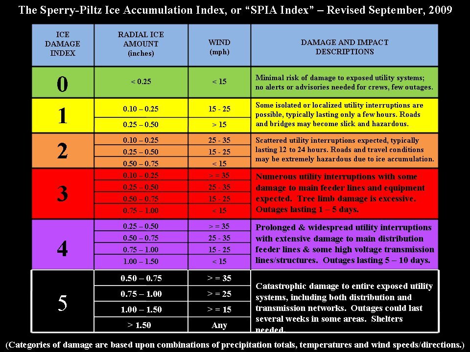
Probably heading to staging areas around Tennessee and around Mississippi. Some of those states could get 1 inch of ice.
.thumb.png.96c09efdeab2bc4e7ddefd2859347e1c.png) Information from the NWS-Louisville.
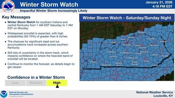
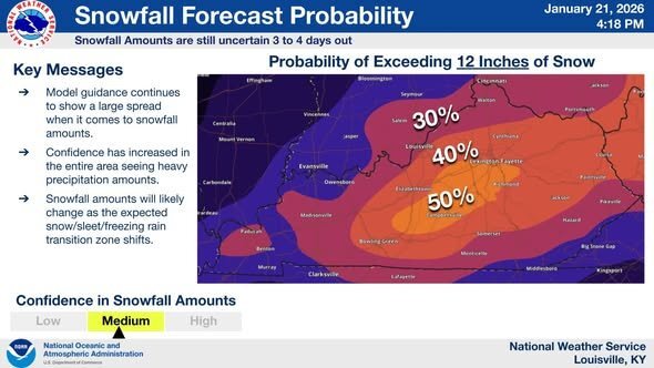
Information from the NWS-Louisville.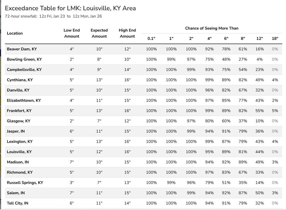
.thumb.png.92b95b11d1232039497930fe7df9d0f6.png)
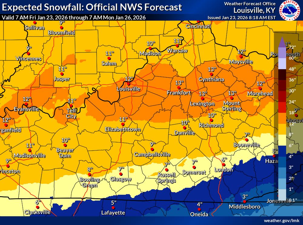 My second call for snow.
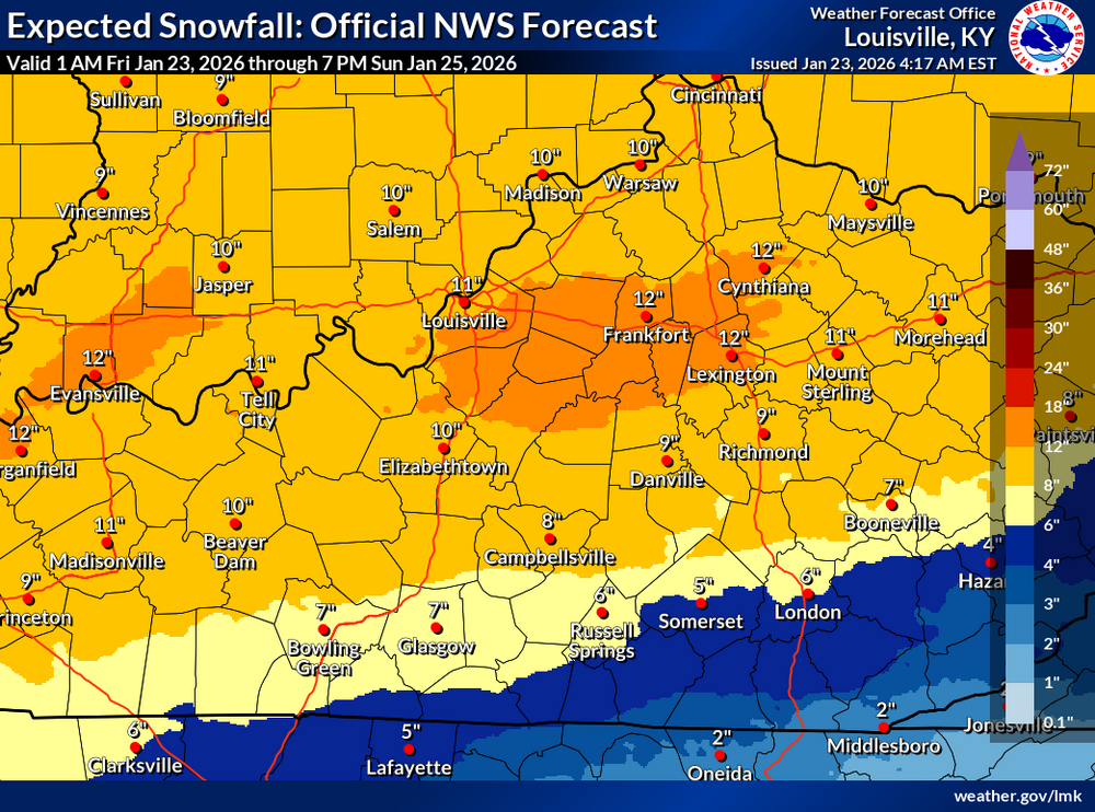
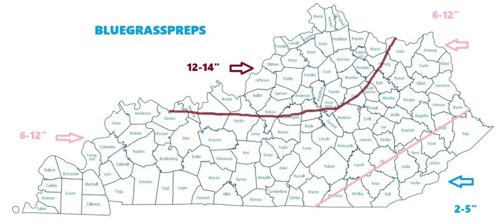 These maps were just released. They now go through today to 7 pm Sunday. They are updated every hour. The range is 72 hours into the future.
.thumb.png.82f5e4273b1da936e74459ae83f2526e.png)
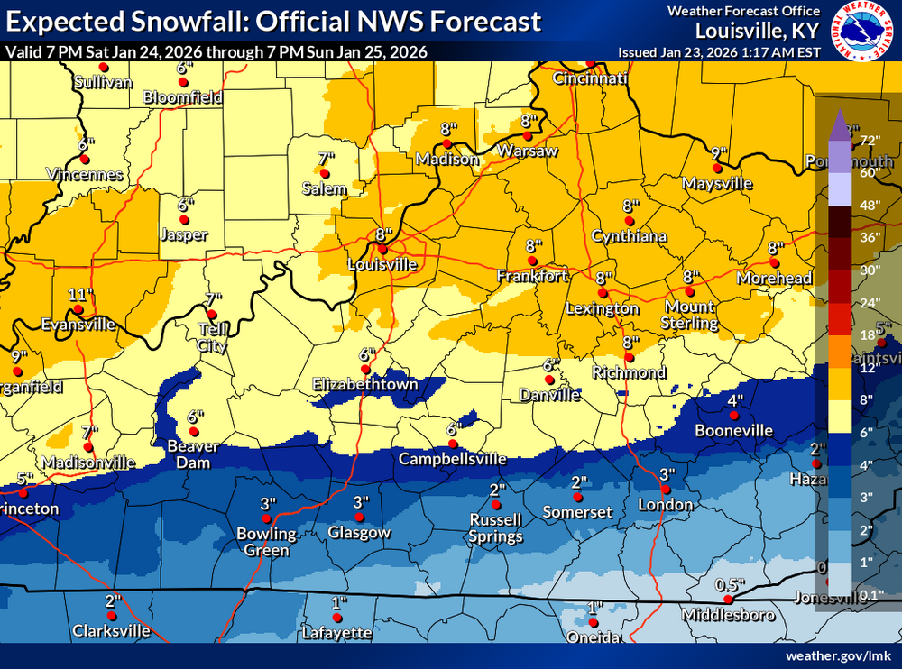
 URGENT - WEATHER MESSAGE National Weather Service Jackson KY 345 AM EST Fri Jan 23 2026 KYZ044-050>052-058>060-068-069-079-080-083>088-104-106>120-232215- /O.NEW.KJKL.CW.Y.0002.260124T0000Z-260124T1700Z/ Fleming-Montgomery-Bath-Rowan-Estill-Powell-Menifee-Rockcastle- Jackson-Pulaski-Laurel-Wayne-McCreary-Whitley-Knox-Bell-Harlan- Elliott-Morgan-Johnson-Wolfe-Magoffin-Floyd-Lee-Breathitt-Knott- Owsley-Perry-Clay-Leslie-Letcher-Martin-Pike- Including the cities of Annville, London, Barbourville, Cumberland, Ravenna, Brodhead, Mount Vernon, Williamsburg, Salyersville, Jackson, Prestonsburg, Somerset, Coal Run, Pineville, Hindman, Clay City, Wheelwright, Campton, Hazard, Paintsville, Jenkins, Stanton, Monticello, Hyden, Flemingsburg, Jeffersonville, Inez, Elkhorn City, Owingsville, Camargo, Beattyville, West Liberty, South Williamson, Whitesburg, Manchester, Middlesboro, Frenchburg, Pikeville, Booneville, Corbin, Irvine, Stearns, Morehead, Harlan, McKee, Sandy Hook, Whitley City, Burnside, Pippa Passes, and Mount Sterling 345 AM EST Fri Jan 23 2026 ...COLD WEATHER ADVISORY IN EFFECT FROM 7 PM THIS EVENING TO NOON EST SATURDAY... * WHAT...Very cold wind chills as low as 5 below expected. * WHERE...Portions of east central, northeast, south central, and southeast Kentucky. * WHEN...From 7 PM this evening to noon EST Saturday. * IMPACTS...Frostbite and hypothermia will occur if unprotected skin is exposed to these temperatures. PRECAUTIONARY/PREPAREDNESS ACTIONS... Use caution while traveling outside. Wear appropriate clothing, a hat, and gloves. Keep pets indoors as much as possible.URGENT - WEATHER MESSAGE National Weather Service Louisville KY 417 AM EST Fri Jan 23 2026 INZ076>079-083-084-089>092-KYZ023>043-045>049-053>057-061>067- 070>078-081-082-232200- /O.NEW.KLMK.CW.Y.0002.260124T0000Z-260124T1700Z/ Orange-Washington IN-Scott IN-Jefferson IN-Dubois-Crawford-Perry- Harrison IN-Floyd-Clark IN-Hancock-Breckinridge-Meade-Ohio- Grayson-Hardin-Bullitt-Jefferson-Oldham-Trimble-Henry-Shelby- Franklin-Scott KY-Harrison KY-Spencer-Anderson-Woodford-Fayette- Bourbon-Nicholas-Nelson-Washington KY-Mercer-Jessamine-Clark KY- Larue-Marion-Boyle-Garrard-Madison-Butler-Edmonson-Hart-Green- Taylor-Casey-Lincoln-Logan-Warren-Simpson-Allen-Barren-Monroe- Metcalfe-Adair-Russell-Cumberland-Clinton- Including the cities of Jamestown, Winchester, Morgantown, Hawesville, Lexington, Columbia, Tell City, Jasper, Nicholasville, La Grange, Hardinsburg, Edmonton, Paris, Springfield, Bowling Green, Burkesville, Madison, Leitchfield, Milton, Bedford, Scottsburg, Salem, Richmond, Lebanon, Corydon, Lewisport, Shelbyville, Jeffersonville, Bardstown, Scottsville, Carlisle, Greensburg, Frankfort, Liberty, Stanford, Paoli, English, Lawrenceburg, Danville, Brownsville, Shepherdsville, Glasgow, New Albany, Hodgenville, Georgetown, Versailles, Providence, Tompkinsville, Horse Cave, Louisville, Franklin, Elizabethtown, Brandenburg, Russellville, New Castle, Cynthiana, Taylorsville, Harrodsburg, Lancaster, Campbellsville, Albany, and Hartford 417 AM EST Fri Jan 23 2026 /317 AM CST Fri Jan 23 2026/ ...COLD WEATHER ADVISORY IN EFFECT FROM 7 PM EST /6 PM CST/ THIS EVENING TO NOON EST /11 AM CST/ SATURDAY... * WHAT...Very cold wind chills as low as 11 below expected. * WHERE...Portions of south central Indiana and central Kentucky. * WHEN...From 7 PM EST /6 PM CST/ this evening to noon EST /11 AM CST/ Saturday. * IMPACTS...The cold wind chills as low as 10 below zero could result in hypothermia if precautions are not taken. PRECAUTIONARY/PREPAREDNESS ACTIONS... Use caution while traveling outside. Wear appropriate clothing, a hat, and gloves.I finally figured out how to get these maps. They just cover the 24-hour period from 7 pm Saturday to 7 pm Sunday. I would assume that is EST.
.thumb.png.0fd613b40d3553cd1d2e83818c9787bf.png)
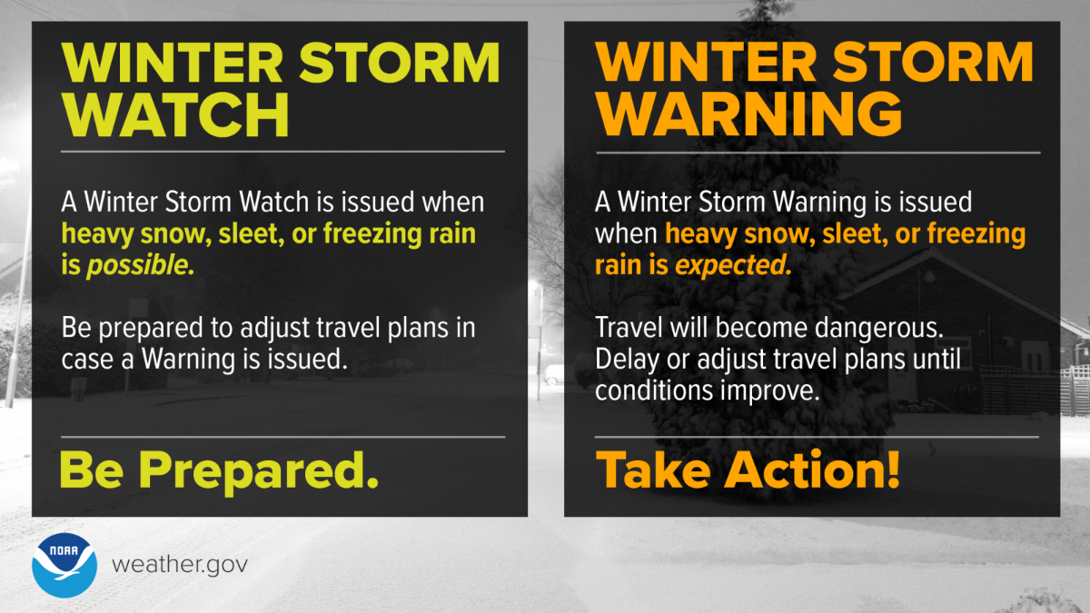
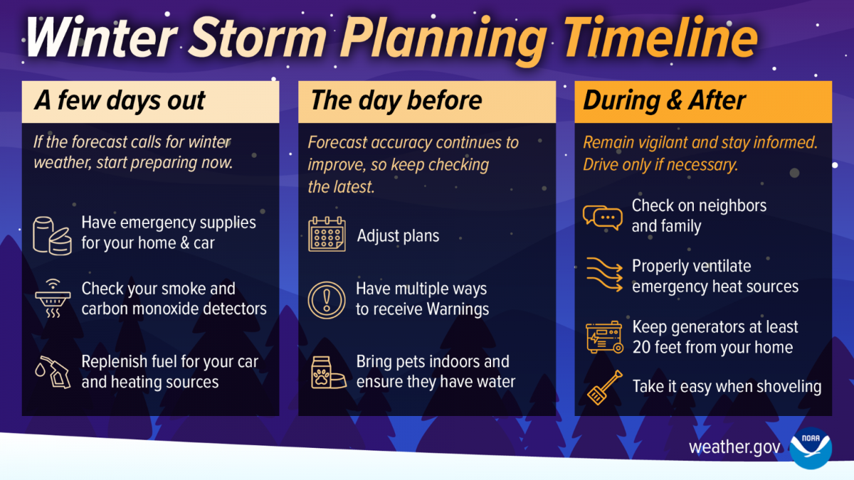
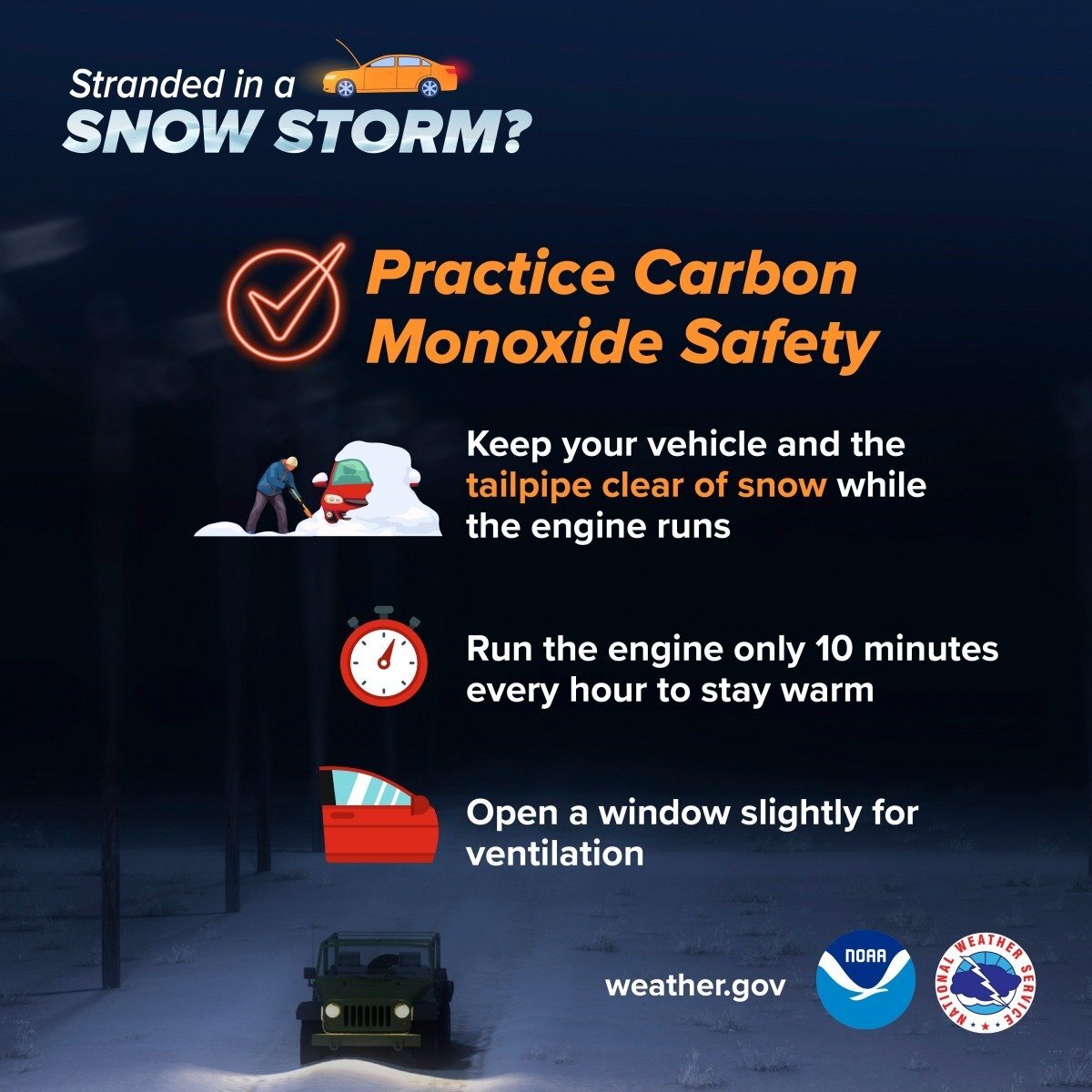
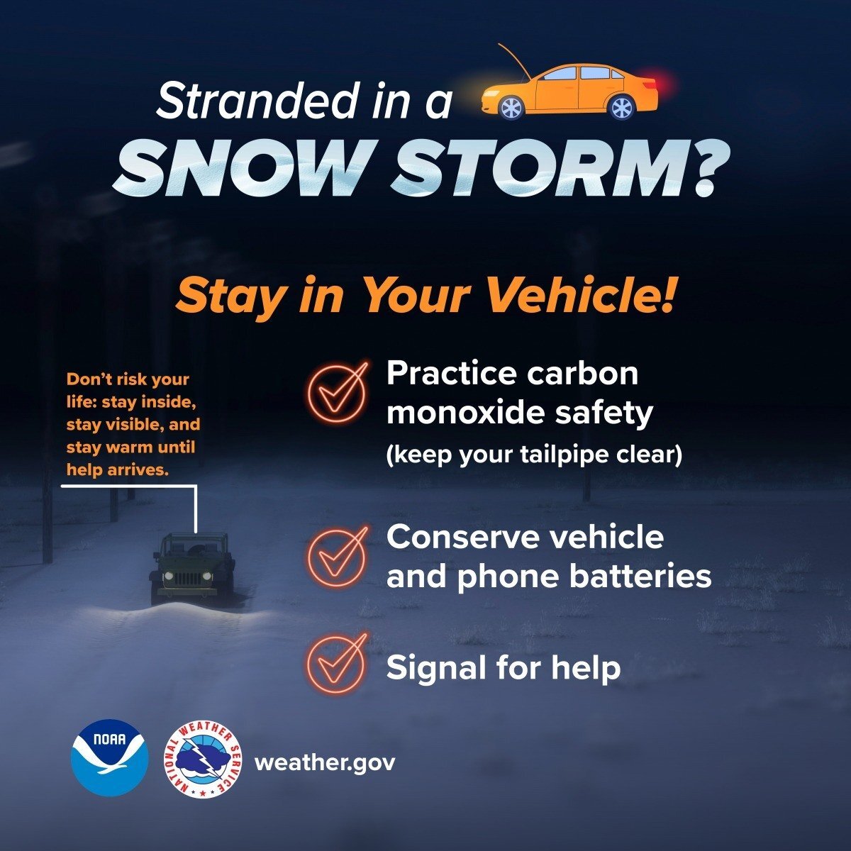
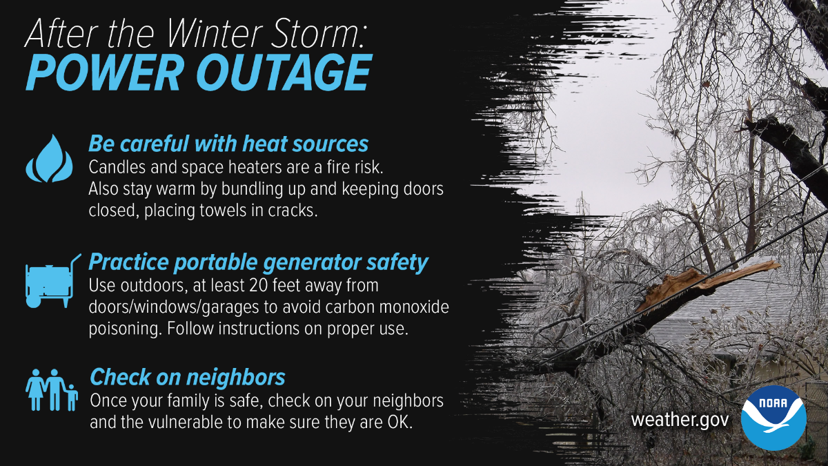
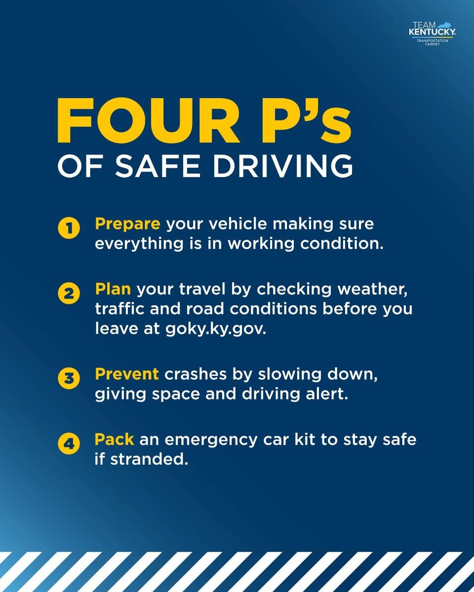
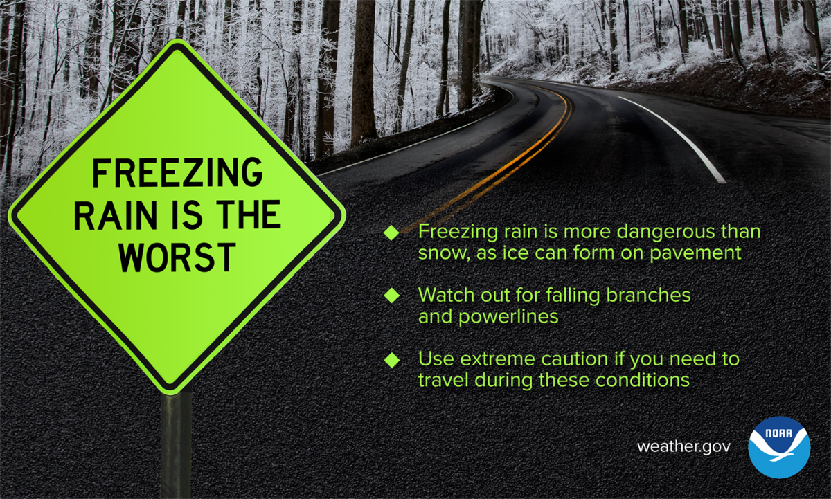
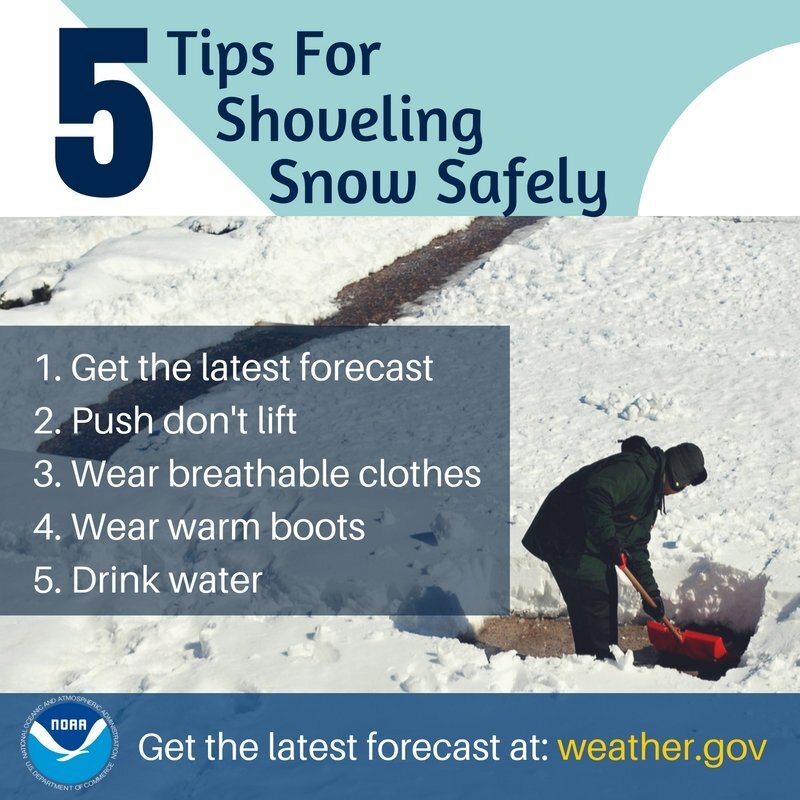
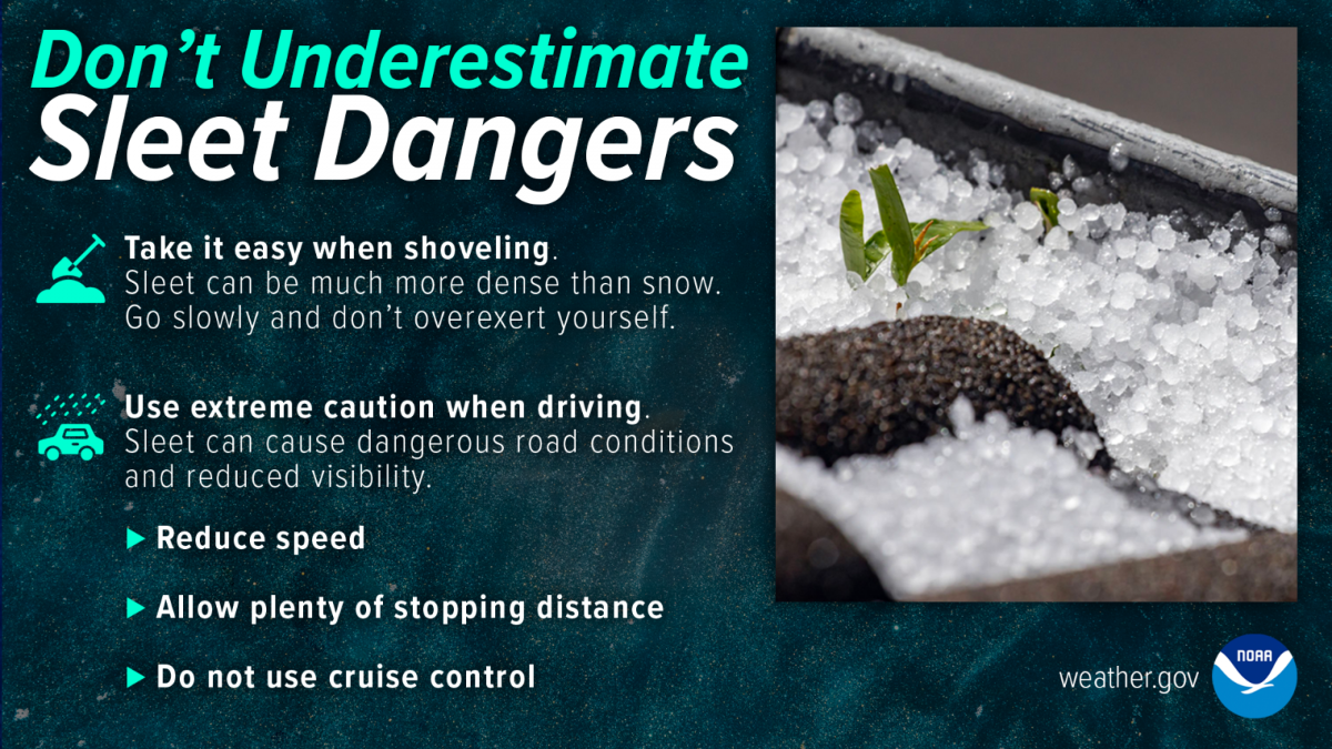
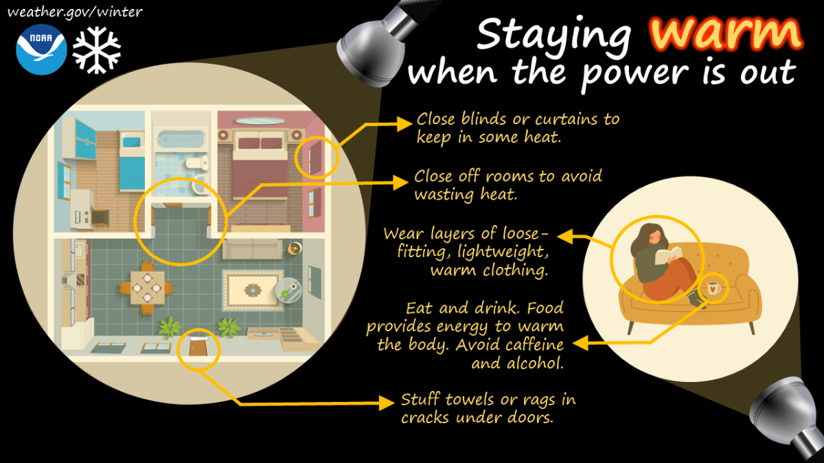
 URGENT - WINTER WEATHER MESSAGE National Weather Service Wilmington OH 127 AM EST Fri Jan 23 2026 INZ050-058-059-066-073-074-OHZ042>046-051>056-060>065-070>072-074- 077-232000- /O.UPG.KILN.WS.A.0001.260124T1200Z-260126T0600Z/ /O.NEW.KILN.WS.W.0001.260124T1500Z-260126T1700Z/ Wayne-Fayette-Union-Franklin-Ripley-Dearborn-Darke-Shelby-Logan- Union-Delaware-Miami-Champaign-Clark-Madison-Franklin-Licking- Preble-Montgomery-Greene-Fayette-Pickaway-Fairfield-Butler-Warren- Clinton-Hocking-Hamilton- Including the cities of Newark, Liberty, Troy, Versailles, Connersville, Bright, Beavercreek, Middletown, Eaton, Greendale, London, Plain City, Logan, Osgood, Urbana, Downtown Cincinnati, Wilmington, Marysville, Milan, Piqua, Brookville, Hidden Valley, Tipp City, Kettering, Franklin, Greenville, Washington Court House, Springfield, Camden, Lancaster, Oxford, Downtown Dayton, Batesville, Xenia, Lebanon, Pickerington, Blanchester, Mason, Landen, Aurora, Delaware, Circleville, Bellefontaine, Fairfield, Springboro, West College Corner, Richmond, Fairborn, Hamilton, West Jefferson, Downtown Columbus, Lawrenceburg, Dillsboro, and Sidney 127 AM EST Fri Jan 23 2026 ...WINTER STORM WARNING IN EFFECT FROM 10 AM SATURDAY TO NOON EST MONDAY... * WHAT...Heavy snow expected. Total snow accumulations between 8 and 12 inches. * WHERE...Portions of east central and southeast Indiana and central, southwest, and west central Ohio. * WHEN...From 10 AM Saturday to noon EST Monday. * IMPACTS...Travel could be very difficult to impossible. The hazardous conditions could impact the Monday morning commute. PRECAUTIONARY/PREPAREDNESS ACTIONS... If you must travel, keep an extra flashlight, food, and water in your vehicle in case of an emergency. In Indiana, visit 511in.org or call 1-800-261-7623 for the latest road information. In Ohio, visit ohgo.com for the latest road information.We have another shot at some accumulating snow around the end of next week.Please heed the safety tips about shoveling snow. Last January I wound up in the hospital for three days with a diagnosed heart attack after shoveling some snow.I completely forgot about this afternoon's conference call. Here are the infographics they sent me. There's another call scheduled for Friday afternoon.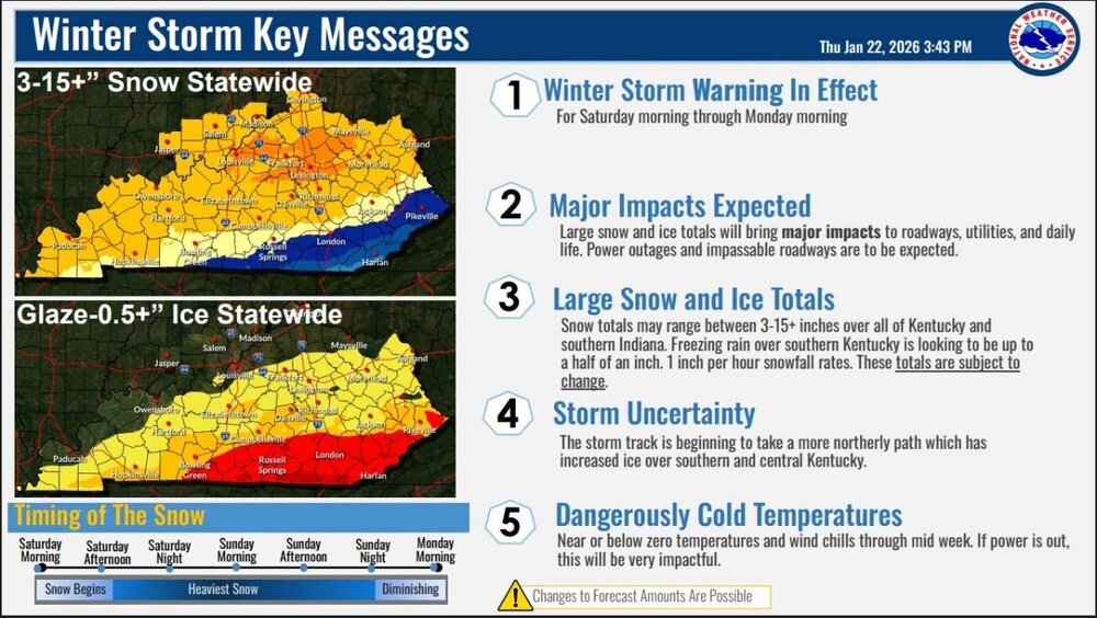

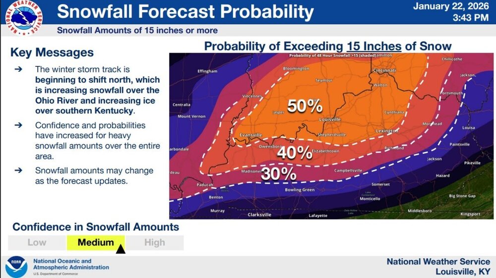
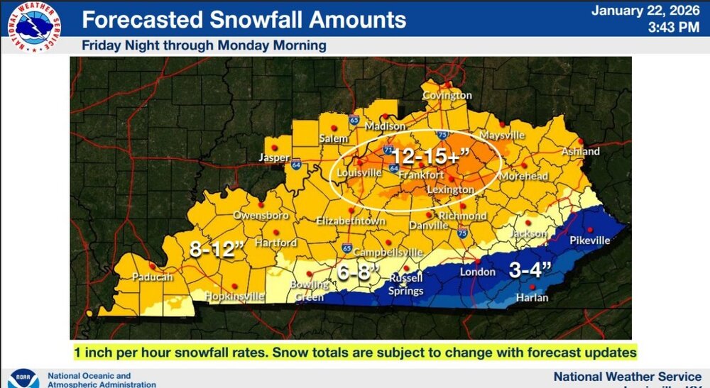
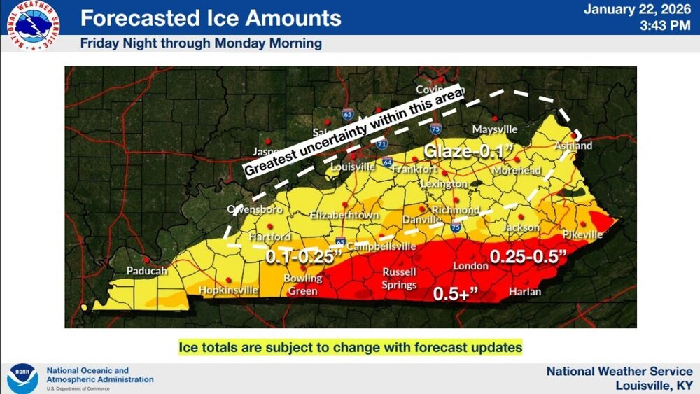
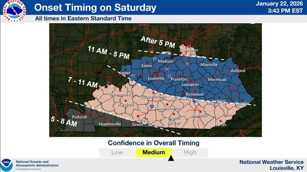
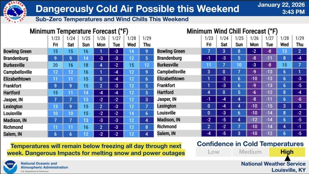 I believe that is the name they give this storm. Same as the names of hurricanes.This is my first call for possible snow accumulations. When new information becomes available, I will update this map.
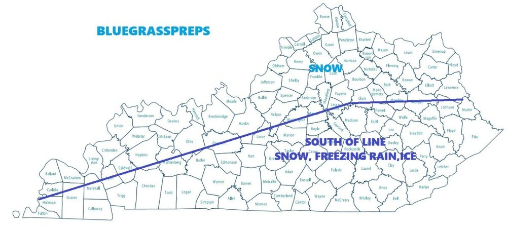
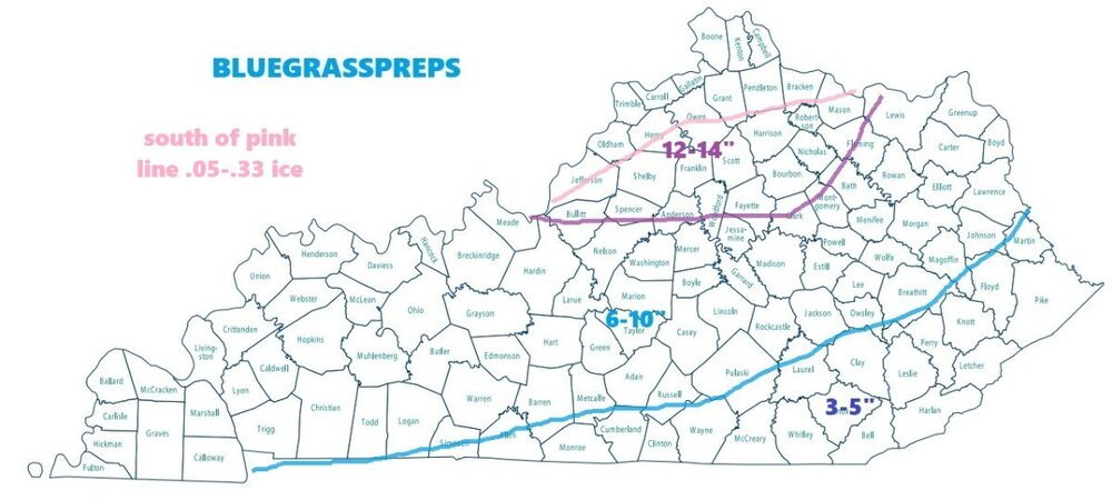 URGENT - WINTER WEATHER MESSAGE National Weather Service Paducah KY 1158 AM CST Thu Jan 22 2026 ...MAJOR WINTER STORM EXPECTED TO IMPACT THE REGION... .Snow is expected to begin overnight Saturday night, periods of sleet will mix in over western Kentucky and far southeast Missouri. The majority of the event is expected to persist at heavy snow through Sunday afternoon. ILZ075>078-080>094-INZ081-082-085>088-KYZ001>022-MOZ076-086-087-100- 107>112-114-230400- /O.UPG.KPAH.WS.A.0001.260124T0600Z-260125T1800Z/ /O.NEW.KPAH.WS.W.0001.260124T0600Z-260126T0000Z/ Jefferson-Wayne IL-Edwards-Wabash-Perry IL-Franklin-Hamilton- White-Jackson-Williamson-Saline-Gallatin-Union-Johnson-Pope- Hardin-Alexander-Pulaski-Massac-Gibson-Pike-Posey-Vanderburgh- Warrick-Spencer-Fulton-Hickman-Carlisle-Ballard-McCracken-Graves- Livingston-Marshall-Calloway-Crittenden-Lyon-Trigg-Caldwell-Union KY-Webster-Hopkins-Christian-Henderson-Daviess-McLean-Muhlenberg- Todd-Perry MO-Bollinger-Cape Girardeau-Wayne MO-Carter-Ripley- Butler-Stoddard-Scott-Mississippi-New Madrid- Including the cities of Greenville, New Madrid, Paducah, Clinton, Benton, Doniphan, Carbondale, Shawneetown, Boonville, Herrin, Madisonville, Marion, Albion, Bardwell, Owensboro, Rockport, Mount Carmel, Cairo, Mayfield, Murray, Vienna, Poseyville, Morganfield, Dixon, Hopkinsville, Golconda, Wickliffe, Calhoun, Sikeston, Perryville, Harrisburg, Smithland, Pinckneyville, Fort Branch, Elkton, Cape Girardeau, Murphysboro, Van Buren, Metropolis, Piedmont, Mount Vernon, Eddyville, West Frankfort, Poplar Bluff, Jackson, Princeton, Henderson, Carmi, McLeansboro, Hickman, Marble Hill, Fairfield, Petersburg, Evansville, Bloomfield, Cadiz, Jonesboro, Elizabethtown, Mound City, and Charleston 1158 AM CST Thu Jan 22 2026 /1258 PM EST Thu Jan 22 2026/ ...WINTER STORM WARNING IN EFFECT FROM MIDNIGHT CST /1 AM EST/ FRIDAY NIGHT TO 6 PM CST /7 PM EST/ SUNDAY... * WHAT...Heavy snow. A band of 8 to 13 inch accumulations across parts of southern Illinois, southeast Missouri, southwest Indiana and western Kentucky. 6 to 10 inches in other locations across southern Illinois and far southwest Kentucky. Periods of heavy sleet in far southeast Missouri and western Kentucky with freezing rain mixed in. Some sleet accumulation and up to a light glaze of freezing rain. * WHERE...All southern Illinois, southwest Indiana, western Kentucky, and southeast Missouri. * WHEN...From midnight CST /1 AM EST/ Friday Night to 6 PM CST /7 PM EST/ Sunday. * IMPACTS...Travel could be very difficult and may become impossible at times. Extreme cold will exacerbate the danger. PRECAUTIONARY/PREPAREDNESS ACTIONS... If you must travel, keep an extra flashlight, food, and water in your vehicle in case of an emergency. The latest road conditions can be obtained by visiting www.weather.gov/pah/roadsURGENT - WINTER WEATHER MESSAGE National Weather Service Louisville KY 128 PM EST Thu Jan 22 2026 INZ076>079-083-084-089>092-KYZ023>043-045>049-053>057-061>067- 070>078-081-082-231000- /O.UPG.KLMK.WS.A.0001.260124T0600Z-260126T1200Z/ /O.NEW.KLMK.WS.W.0001.260124T0600Z-260126T1200Z/ Orange-Washington IN-Scott IN-Jefferson IN-Dubois-Crawford-Perry- Harrison IN-Floyd-Clark IN-Hancock-Breckinridge-Meade-Ohio- Grayson-Hardin-Bullitt-Jefferson-Oldham-Trimble-Henry-Shelby- Franklin-Scott KY-Harrison KY-Spencer-Anderson-Woodford-Fayette- Bourbon-Nicholas-Nelson-Washington KY-Mercer-Jessamine-Clark KY- Larue-Marion-Boyle-Garrard-Madison-Butler-Edmonson-Hart-Green- Taylor-Casey-Lincoln-Logan-Warren-Simpson-Allen-Barren-Monroe- Metcalfe-Adair-Russell-Cumberland-Clinton- Including the cities of Corydon, Taylorsville, Hodgenville, Russellville, Scottsville, Jamestown, Brownsville, Winchester, Providence, Shepherdsville, Columbia, Versailles, Edmonton, Elizabethtown, Lexington, Liberty, Paris, Lebanon, Tompkinsville, Paoli, Madison, Hawesville, Tell City, Louisville, Shelbyville, Harrodsburg, Horse Cave, Albany, New Albany, Richmond, Brandenburg, Leitchfield, Hartford, Milton, Franklin, Lawrenceburg, Lewisport, Hardinsburg, Bedford, Nicholasville, Stanford, Morgantown, Jeffersonville, Cynthiana, Glasgow, Bowling Green, Lancaster, Springfield, Campbellsville, Salem, New Castle, Georgetown, Scottsburg, Frankfort, Carlisle, Danville, Burkesville, Bardstown, English, La Grange, Jasper, and Greensburg 128 PM EST Thu Jan 22 2026 /1228 PM CST Thu Jan 22 2026/ ...WINTER STORM WARNING IN EFFECT FROM 1 AM EST /MIDNIGHT CST/ SATURDAY TO 7 AM EST /6 AM CST/ MONDAY... * WHAT...Heavy snow mixed with sleet and freezing rain along and south of the Bluegrass and Western Kentucky Parkways. South of the parkways, storm total snow and sleet 4 to 10 inches with up to a third of an inch of ice accumulation. North of the parkways mainly snow, heavy at times. Total snow accumulations between 10 and 14 inches. Locazlized higher amounts possible. * WHERE...Portions of south central Indiana and east central, north central, northwest, and south central Kentucky. * WHEN...From 1 AM EST /midnight CST/ Saturday to 7 AM EST /6 AM CST/ Monday. * IMPACTS...Travel could be very difficult to impossible. PRECAUTIONARY/PREPAREDNESS ACTIONS... If you must travel, keep an extra flashlight, food, and water in your vehicle in case of an emergency. In Indiana, for Indiana Road Conditions please visit http://511in.org In Kentucky, for Kentucky Road Conditions please visit http://goky.ky.govThose south of the line should be preparing for power outages or interruptions. Road and travel conditions may be extremely hazardous due to ice accumulation.
 Update for northern Kentucky. URGENT - WINTER WEATHER MESSAGE National Weather Service Wilmington OH 205 AM EST Thu Jan 22 2026 INZ075-080-KYZ089>100-OHZ073-078>082-088-222115- /O.CON.KILN.WS.A.0001.260124T1200Z-260126T0600Z/ Ohio-Switzerland-Carroll-Gallatin-Boone-Kenton-Campbell-Owen- Grant-Pendleton-Bracken-Robertson-Mason-Lewis-Ross-Clermont-Brown- Highland-Adams-Pike-Scioto- Including the cities of Hillsboro, Alexandria, Mulberry, Greenfield, Vevay, Burlington, Butler, Georgetown, Owenton, Williamstown, Brooksville, Camp Dix, Aberdeen, Waverly, Erlanger, Mount Repose, Dayton, Highland Heights, Vanceburg, Winchester, Piketon, Oakbrook, Tollesboro, Ripley, Dry Ridge, Carrollton, Augusta, Maysville, Milford, Crittenden, Wheelersburg, Falmouth, Florence, Mount Carmel, Pike Lake, Portsmouth, Covington, Warsaw, Chillicothe, Head Of Grassy, Withamsville, Seaman, Bellevue, Day Heights, Summerside, Rising Sun, Mount Olivet, Independence, Fort Thomas, Mount Orab, Newport, Manchester, Peebles, and West Union 205 AM EST Thu Jan 22 2026 ...WINTER STORM WATCH REMAINS IN EFFECT FROM SATURDAY MORNING THROUGH LATE SUNDAY NIGHT... * WHAT...Heavy snow possible. Total snow accumulations between 8 and 11 inches possible. * WHERE...Portions of southeast Indiana, northeast and northern Kentucky, and south central and southwest Ohio. * WHEN...From Saturday afternoon through late Sunday night. * IMPACTS...Travel could be very difficult. PRECAUTIONARY/PREPAREDNESS ACTIONS... Persons should consider altering their travel plans. If you do plan to travel in hazardous winter conditions, consider taking a winter storm kit along with you, including such items as tire chains, booster cables, flashlight, shovel, blankets and extra clothing. Also take water, a first aid kit, and anything else that would help you survive in case you become stranded.Update for the Cincinnati area. URGENT - WINTER WEATHER MESSAGE National Weather Service Wilmington OH 205 AM EST Thu Jan 22 2026 INZ073-074-OHZ063>065-071-072-074-077-222115- /O.EXA.KILN.WS.A.0001.260124T1200Z-260126T0600Z/ Ripley-Dearborn-Fayette-Pickaway-Fairfield-Warren-Clinton-Hocking- Hamilton- Including the cities of Landen, Wilmington, Greendale, Lawrenceburg, Lebanon, Washington Court House, Logan, Hidden Valley, Downtown Cincinnati, Franklin, Circleville, Blanchester, Pickerington, Milan, Batesville, Aurora, Lancaster, Osgood, Mason, Springboro, Dillsboro, Bright, and Versailles 205 AM EST Thu Jan 22 2026 ...WINTER STORM WATCH IN EFFECT FROM SATURDAY MORNING THROUGH LATE SUNDAY NIGHT... * WHAT...Heavy snow possible. Total snow accumulations between 6 and 10 inches possible. * WHERE...In Indiana, Dearborn and Ripley Counties. In Ohio, Fairfield, Fayette, Hocking, Pickaway, Clinton, Hamilton, and Warren Counties. * WHEN...From Saturday afternoon through late Sunday night. * IMPACTS...Travel could be very difficult. PRECAUTIONARY/PREPAREDNESS ACTIONS... Prepare for hazardous winter weather conditions. Continue to monitor the latest forecasts for updates on this situation. &&I think it depends if the high pressure system that is forecast to be around Michigan. If it strengthens it could push the system back south. It's too early to tell at the moment. The 18z GFS is showing a shift to the south.

.png.72a13579c09195538bc9a71985105add.png)

.png.957740c47d0288f514476a9f00441dbe.png)


.png.acb1e115f98a7c0fd869018092f0b82d.png)


.png.243c88ca86dd77a0fe6fe01255b43ca5.png)







Account
Navigation
Search
Configure browser push notifications
Chrome (Android)
- Tap the lock icon next to the address bar.
- Tap Permissions → Notifications.
- Adjust your preference.
Chrome (Desktop)
- Click the padlock icon in the address bar.
- Select Site settings.
- Find Notifications and adjust your preference.
Safari (iOS 16.4+)
- Ensure the site is installed via Add to Home Screen.
- Open Settings App → Notifications.
- Find your app name and adjust your preference.
Safari (macOS)
- Go to Safari → Preferences.
- Click the Websites tab.
- Select Notifications in the sidebar.
- Find this website and adjust your preference.
Edge (Android)
- Tap the lock icon next to the address bar.
- Tap Permissions.
- Find Notifications and adjust your preference.
Edge (Desktop)
- Click the padlock icon in the address bar.
- Click Permissions for this site.
- Find Notifications and adjust your preference.
Firefox (Android)
- Go to Settings → Site permissions.
- Tap Notifications.
- Find this site in the list and adjust your preference.
Firefox (Desktop)
- Open Firefox Settings.
- Search for Notifications.
- Find this site in the list and adjust your preference.