

nWo
BGP Meteorologist
-
Joined
-
Last visited
Everything posted by nWo
-
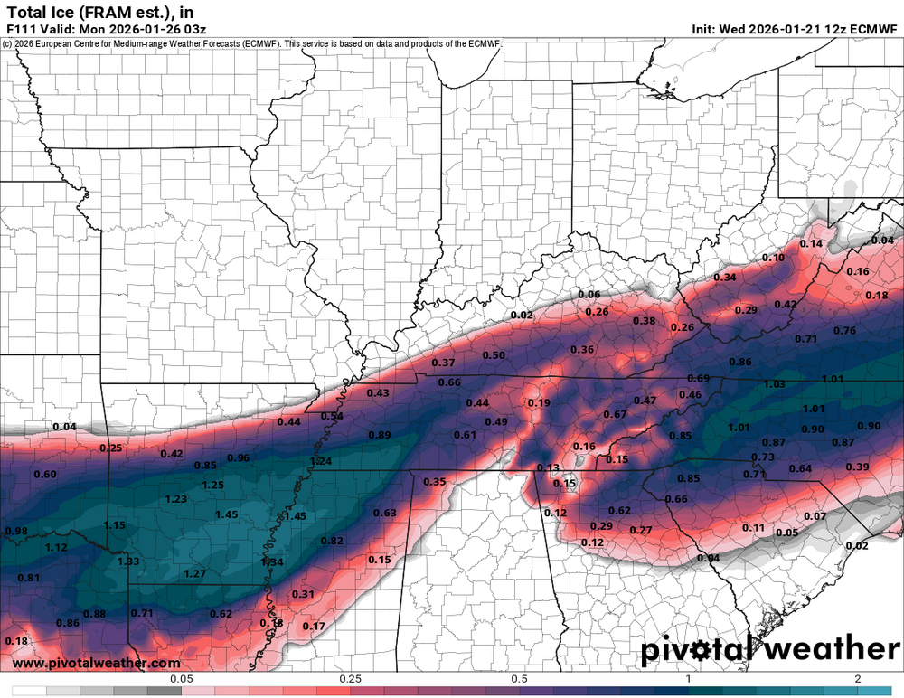
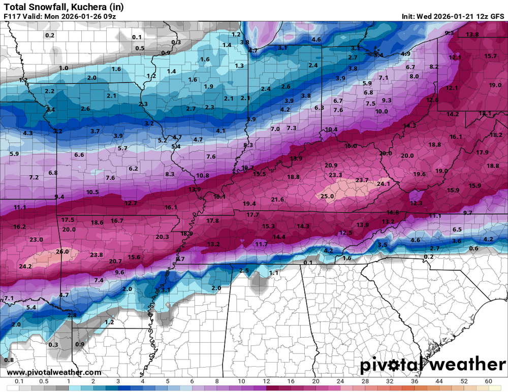
Here is what the GFS and Euro are showing. This is from the 12z run.
.thumb.png.dea1cf9fb46ddd00a5dab1017a06462e.png)
.thumb.png.a0fb45bd1cfdb871262dee2939c63612.png)
-
I agree with you.
-
Check back for my update later today. I'm waiting for the 12z Euro to be released to see how it compares to the GFS. If it does ??
-
I'll start a new thread tomorrow when I make my first call for snow.
-
The NWS-Louisville office has scheduled a conference call for 3 pm tomorrow about the storm.
-
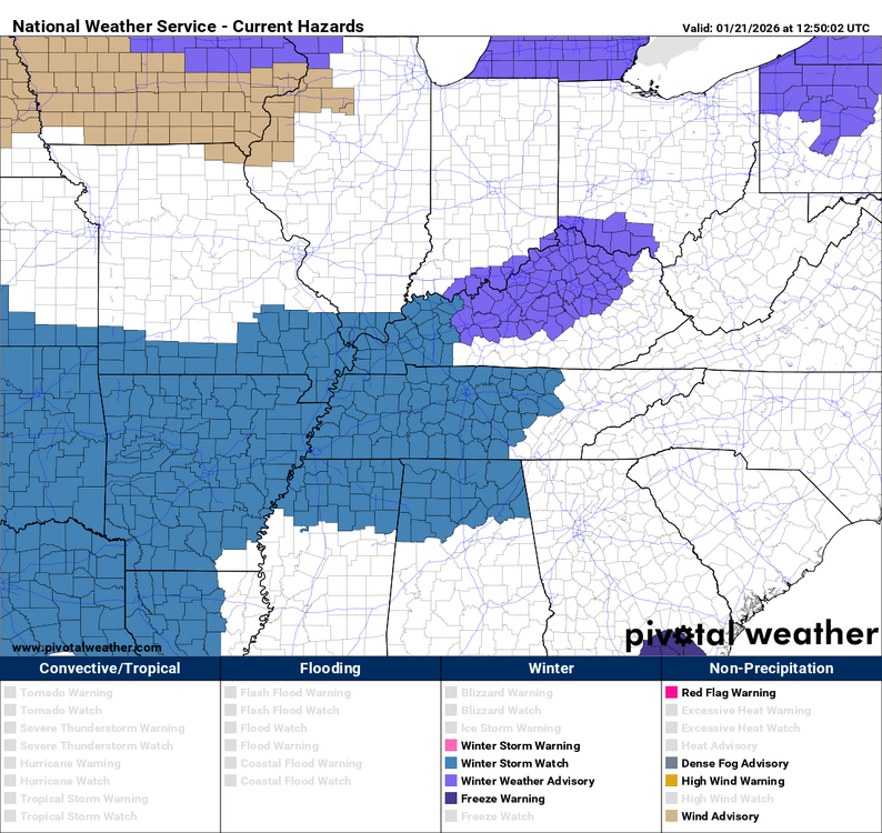
The entire state is now under a winter storm watch. URGENT - WINTER WEATHER MESSAGE National Weather Service Wilmington OH 1230 PM EST Wed Jan 21 2026 INZ075-080-KYZ089>100-OHZ073-078>082-088-220730- /O.NEW.KILN.WS.A.0001.260124T1200Z-260126T0600Z/ Ohio-Switzerland-Carroll-Gallatin-Boone-Kenton-Campbell-Owen- Grant-Pendleton-Bracken-Robertson-Mason-Lewis-Ross-Clermont-Brown- Highland-Adams-Pike-Scioto- Including the cities of Newport, Withamsville, Camp Dix, Warsaw, Carrollton, Bellevue, Dayton, Greenfield, Chillicothe, Highland Heights, Ripley, Manchester, Butler, Augusta, Aberdeen, Rising Sun, Mulberry, Alexandria, Tollesboro, Erlanger, Peebles, Day Heights, Vevay, Brooksville, Mount Carmel, Owenton, Hillsboro, Mount Repose, Portsmouth, Milford, Dry Ridge, Seaman, Crittenden, Burlington, Florence, Georgetown, Wheelersburg, Independence, Mount Orab, Waverly, Oakbrook, West Union, Winchester, Mount Olivet, Vanceburg, Piketon, Summerside, Falmouth, Covington, Williamstown, Maysville, Pike Lake, Fort Thomas, and Head Of Grassy 1230 PM EST Wed Jan 21 2026 ...WINTER STORM WATCH IN EFFECT FROM SATURDAY MORNING THROUGH LATE SUNDAY NIGHT... * WHAT...Heavy snow with total accumulations between 4 and 6 inches is possible. * WHERE...Portions of southeast Indiana, northeast and northern Kentucky, and south central and southwest Ohio. * WHEN...From Saturday morning through late Sunday night. * IMPACTS...Travel could be very difficult. PRECAUTIONARY/PREPAREDNESS ACTIONS... Persons should consider altering their travel plans. If you do plan to travel in hazardous winter conditions, consider taking a winter storm kit along with you, including such items as tire chains, booster cables, flashlight, shovel, blankets and extra clothing. Also take water, a first aid kit, and anything else that would help you survive in case you become stranded.
.thumb.png.b77b64496df9eee3a684ab626bfb94ab.png)
-
URGENT - WINTER WEATHER MESSAGE National Weather Service Jackson KY 1209 PM EST Wed Jan 21 2026 KYZ044-050>052-058>060-068-069-079-080-083>088-104-106>120-221000- /O.NEW.KJKL.WS.A.0001.260124T1200Z-260126T1200Z/ Fleming-Montgomery-Bath-Rowan-Estill-Powell-Menifee-Rockcastle- Jackson-Pulaski-Laurel-Wayne-McCreary-Whitley-Knox-Bell-Harlan- Elliott-Morgan-Johnson-Wolfe-Magoffin-Floyd-Lee-Breathitt-Knott- Owsley-Perry-Clay-Leslie-Letcher-Martin-Pike- Including the cities of Stearns, Jeffersonville, Prestonsburg, Flemingsburg, Stanton, Mount Vernon, Booneville, Hazard, Paintsville, Whitley City, South Williamson, Campton, Somerset, Burnside, Sandy Hook, Coal Run, Ravenna, Hindman, Jenkins, Elkhorn City, Inez, Pineville, Jackson, Beattyville, Frenchburg, Mount Sterling, Irvine, Owingsville, Whitesburg, Barbourville, Williamsburg, Pippa Passes, Manchester, Monticello, Annville, Pikeville, Brodhead, Hyden, Clay City, Wheelwright, Salyersville, Camargo, Cumberland, West Liberty, McKee, Middlesboro, London, Harlan, Morehead, and Corbin 1209 PM EST Wed Jan 21 2026 ...WINTER STORM WATCH IN EFFECT FROM SATURDAY MORNING THROUGH MONDAY MORNING... * WHAT...A winter storm is expected to bring moderate to major impacts to eastern Kentucky this weekend. Periods of moderate to heavy snow are forecast this weekend with the possibility of a wintry mix of snow, sleet, and freezing rain, especially along and south of the KY-80/Hal Rogers Parkway. * WHERE...Portions of east central, northeast, south central, and southeast Kentucky. * WHEN...From Saturday morning through Monday morning. * IMPACTS...Travel could be very difficult to impossible. The hazardous conditions could impact the Monday morning commute. PRECAUTIONARY/PREPAREDNESS ACTIONS... Monitor the latest forecasts for updates on this situation. Persons should consider delaying all travel. If travel is absolutely necessary, consider taking a winter storm kit along with you, including such items as tire chains, booster cables, flashlight, shovel, blankets and extra clothing. Also take water, a first aid kit, and anything else that would help you survive in case you become stranded.
-
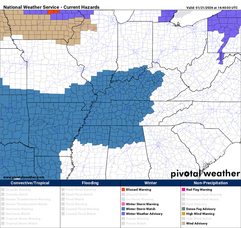
This watch area has just been expanded. URGENT - WINTER WEATHER MESSAGE National Weather Service Louisville KY 1138 AM EST Wed Jan 21 2026 INZ076>079-083-084-089>092-KYZ023>043-045>049-053>057-061>067- 070>078-081-082-221015- /O.NEW.KLMK.WS.A.0001.260124T0600Z-260126T1200Z/ Orange-Washington IN-Scott IN-Jefferson IN-Dubois-Crawford-Perry- Harrison IN-Floyd-Clark IN-Hancock-Breckinridge-Meade-Ohio- Grayson-Hardin-Bullitt-Jefferson-Oldham-Trimble-Henry-Shelby- Franklin-Scott KY-Harrison KY-Spencer-Anderson-Woodford-Fayette- Bourbon-Nicholas-Nelson-Washington KY-Mercer-Jessamine-Clark KY- Larue-Marion-Boyle-Garrard-Madison-Butler-Edmonson-Hart-Green- Taylor-Casey-Lincoln-Logan-Warren-Simpson-Allen-Barren-Monroe- Metcalfe-Adair-Russell-Cumberland-Clinton- Including the cities of Edmonton, Harrodsburg, New Castle, Jamestown, Hartford, Milton, English, Providence, Lancaster, Liberty, Lexington, Winchester, Hodgenville, Elizabethtown, Shepherdsville, Paris, Versailles, Georgetown, Corydon, Carlisle, Scottsburg, Greensburg, Stanford, Danville, Cynthiana, Bowling Green, Brandenburg, Hardinsburg, Lewisport, Franklin, Springfield, Paoli, Richmond, Madison, Tell City, Scottsville, Leitchfield, Burkesville, Salem, Shelbyville, Louisville, Bardstown, Frankfort, Jeffersonville, Morgantown, Horse Cave, Campbellsville, Russellville, Glasgow, Taylorsville, Tompkinsville, Hawesville, New Albany, Nicholasville, Columbia, Jasper, Lebanon, Bedford, Albany, Brownsville, Lawrenceburg, and La Grange 1138 AM EST Wed Jan 21 2026 /1038 AM CST Wed Jan 21 2026/ ...WINTER STORM WATCH IN EFFECT FROM EARLY SATURDAY MORNING THROUGH MONDAY MORNING... * WHAT...A winter storm is expected to bring moderate to major impacts to central Kentucky and southern Indiana this weekend. Periods of moderate to heavy snow are forecast this weekend with the possibility of a wintry mix of snow and sleet across southern Kentucky. * WHERE...Portions of south central Indiana and east central, north central, northwest, and south central Kentucky. * WHEN...From early Saturday morning through Monday morning. * IMPACTS...Plan for considerable disruptions to daily life, Be prepared for dangerous travel conditions and ready to avoid travel if possible. PRECAUTIONARY/PREPAREDNESS ACTIONS... Monitor the latest forecasts for updates on this situation.
-
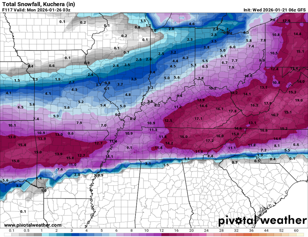
This is what the 06z runs show for possible snow accumulations from both the Euro and GFS models. This is just a shot in time and not an official forecast.
.thumb.png.49881d0e23624d5c8c66611b40d1bd87.png)
-
The first winter storm watch has been just issued for western Kentucky. URGENT - WINTER WEATHER MESSAGE National Weather Service Paducah KY 527 AM CST Wed Jan 21 2026 KYZ001>003-005-006-008-009-011-012-017-022-MOZ086-100-107>110-112- 114-211930- /O.CON.KPAH.WS.A.0001.260124T0600Z-260125T1800Z/ Fulton-Hickman-Carlisle-McCracken-Graves-Marshall-Calloway-Lyon- Trigg-Christian-Todd-Bollinger-Wayne MO-Carter-Ripley-Butler- Stoddard-Mississippi-New Madrid- Including the cities of Paducah, Doniphan, New Madrid, Marble Hill, Hickman, Murray, Eddyville, Van Buren, Hopkinsville, Bloomfield, Piedmont, Clinton, Benton, Bardwell, Cadiz, Mayfield, Elkton, Poplar Bluff, and Charleston 527 AM CST Wed Jan 21 2026 ...WINTER STORM WATCH REMAINS IN EFFECT FROM LATE FRIDAY NIGHT THROUGH SUNDAY MORNING... * WHAT...Periods of moderate to heavy snow will be possible. Total snow accumulations may exceed 5 inches in the Winter Storm Watch area with the greater totals most likely near the Arkansas and Tennessee border in southeast Missouri and western Kentucky. * WHERE...Portions of western Kentucky and southeast Missouri. * WHEN...From late Friday night through Sunday morning. * IMPACTS...Travel could be very difficult. PRECAUTIONARY/PREPAREDNESS ACTIONS... Monitor the latest forecasts for updates on this situation.
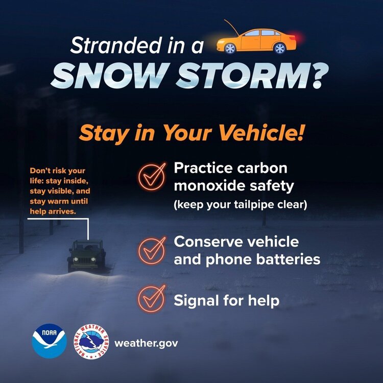
 A period of winter weather and dangerous cold is expected. Now is the time to prepare: Keep thermostats at 65° or higher to protect pipes Drip faucets on exterior walls Charge phones and backup batteries Avoid unnecessary travel once snow and ice begin If driving is necessary, keep a winter safety kit in your vehicle Dress in layers—frostbite can occur in minutes Bring pets indoors and check on elderly neighbors Have food, water, and medications for several days Stay weather-aware and monitor local alerts Prepare now so you don’t have to react later. Stay safe and stay warm.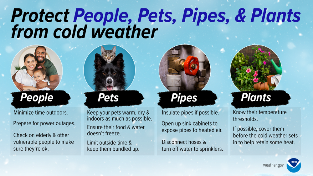
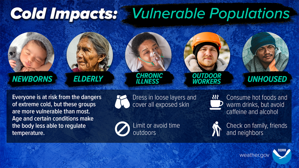
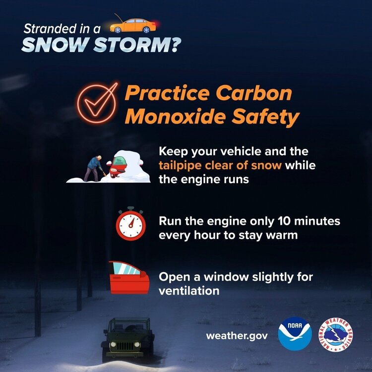
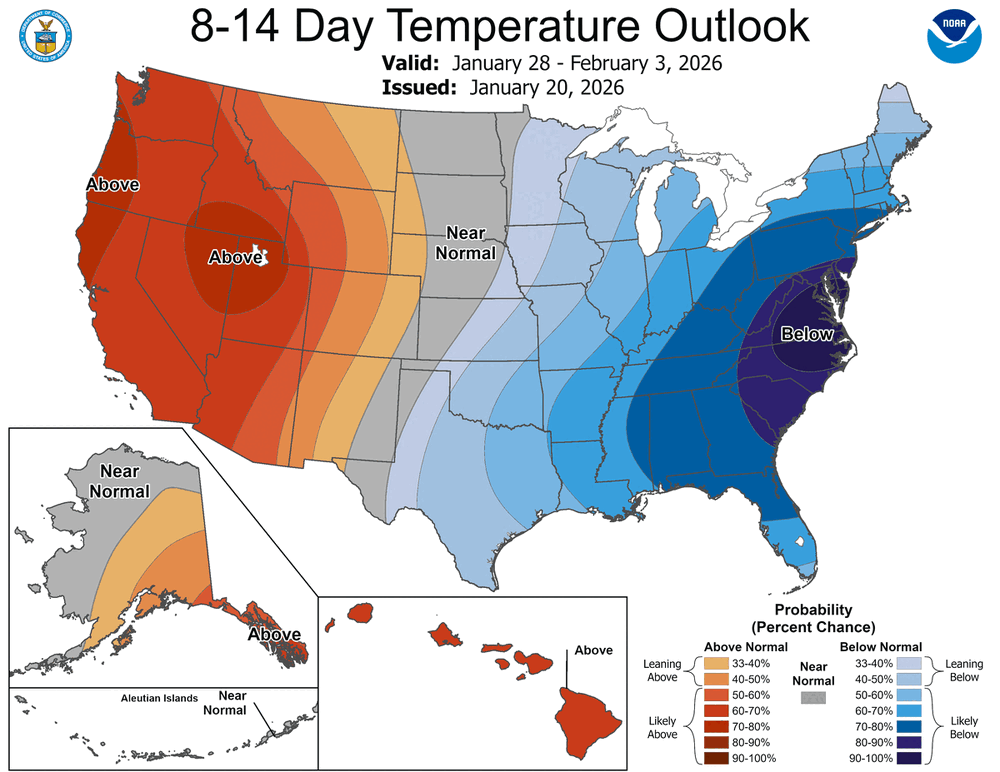
 We are in for some bitterly cold temperatures after this storm is over. It could be the beginning of February before we get any relief temperature-wise.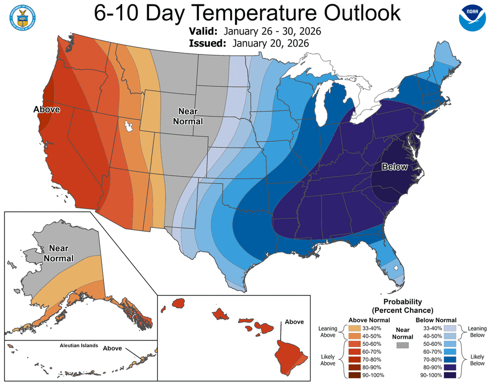
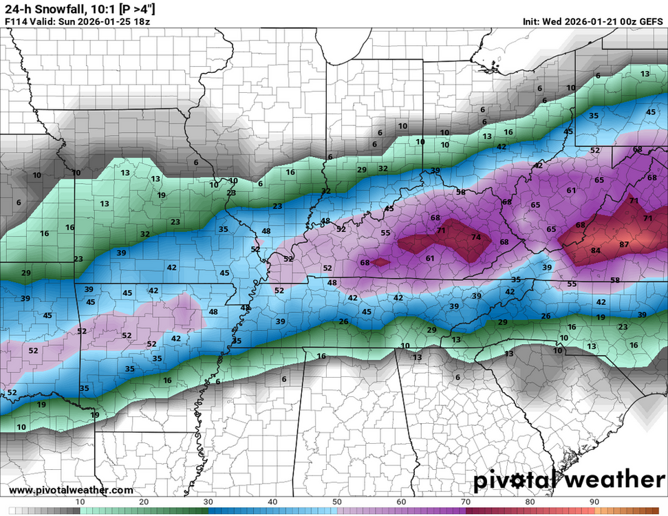
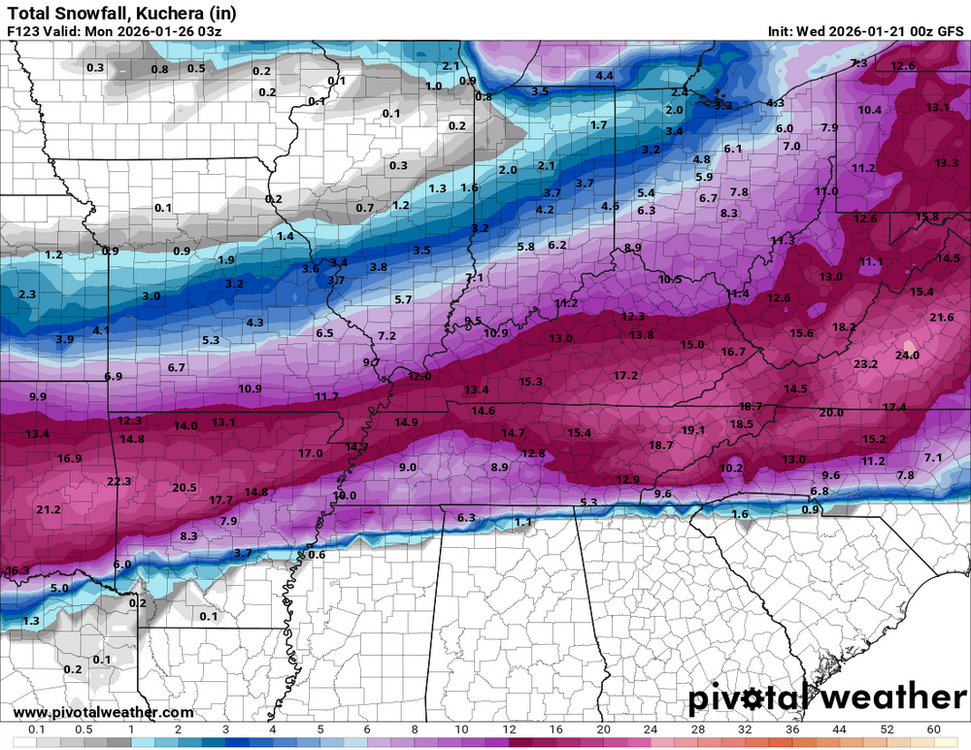
 Here's my update on possible accumulation totals. Confidence is growing that Kentucky and the surrounding area could receive snow totals we haven't seen in about a decade. If these totals come to pass, it may rival the January 1994 storm. The GFS has come into good agreement with the Euro in the last couple of runs. First, the GEFS Ensemble shows the chances of receiving more than an inch. Please note that this model is an average of 21 different members. Some of which may show less chance of snow, so that is why you don't see 100 percent chances yet. There are still some questions on where the exact track and the timing of the storm are. If it takes the track that the Euro is showing, then some icing may come into play for those along the Kentucky/Tennessee border. I fully expect winter storm watches to start going up soon. This one shows the chances of getting more than 4 inches of snow. Here is what the GFS is now showing for accumulations. The Euro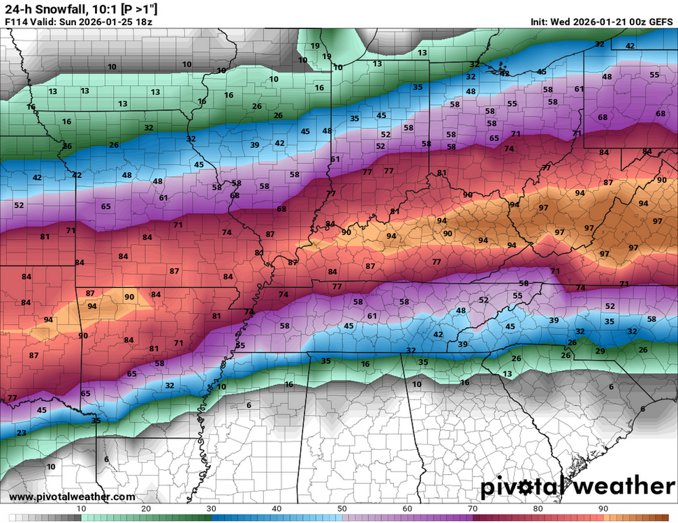
.thumb.png.7bf5b8739bad1fdedf0de9011c2a046b.thumb.png.b37ae9e9c2c5c5a74cbbb75ef38145a6.png)
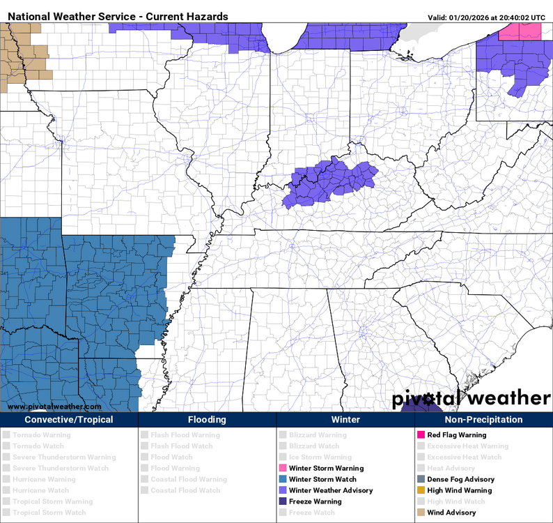
 These are the following criteria that the NWS-Louisville office uses to issue a winter storm watch and warning. Winter Storm Watch: Any combination of snow, sleet, or freezing rain averaging 4 inches or more is expected to occur in the next 2 to 3 days. Winter Storm Warning: Any combination of snow, sleet, or freezing rain averaging 4 inches or more is expected to occur in the next 24 to 48 hours. Winter Storm Warning: Snow averaging ≥ 4” (3-5”, 3-6”, 4-8”, etc.) in an event*, or a combo of significant sleet, ice pellets, or freezing rain. Think impact. *The event duration will be determined by the issuing office, but it will not exceed 48 hours. If an event will last longer than 48 hours, offices should highlight the period of greatest impacts or separate into multiple events.The area for this advisory has been expanded.I'm going to wait and post an update in the morning. I want to see if what the 18z GFS is showing continues. It has brought the track back up to Kentucky, and the possible totals are coming in line with what the other models have been showing.URGENT - WINTER WEATHER MESSAGE National Weather Service Louisville KY 320 PM EST Tue Jan 20 2026 INZ084-089>092-KYZ023>043-045>049-053-211015- /O.NEW.KLMK.WW.Y.0003.260121T0900Z-260121T1600Z/ Crawford-Perry-Harrison IN-Floyd-Clark IN-Hancock-Breckinridge- Meade-Ohio-Grayson-Hardin-Bullitt-Jefferson-Oldham-Trimble-Henry- Shelby-Franklin-Scott KY-Harrison KY-Spencer-Anderson-Woodford- Fayette-Bourbon-Nicholas-Nelson-Washington KY-Mercer-Jessamine- Clark KY-Larue- Including the cities of Lewisport, English, Bardstown, Springfield, Brandenburg, Paris, Carlisle, Milton, Georgetown, Lexington, Elizabethtown, Lawrenceburg, Louisville, Leitchfield, Jeffersonville, Tell City, Hawesville, Harrodsburg, Frankfort, Shepherdsville, Nicholasville, La Grange, New Castle, Bedford, Hodgenville, New Albany, Hardinsburg, Hartford, Winchester, Corydon, Taylorsville, Versailles, Cynthiana, and Shelbyville 320 PM EST Tue Jan 20 2026 /220 PM CST Tue Jan 20 2026/ ...WINTER WEATHER ADVISORY IN EFFECT FROM 4 AM EST /3 AM CST/ TO 11 AM EST /10 AM CST/ WEDNESDAY... * WHAT...Precipitation is expected to develop across the advisory area early Wednesday morning and will likely be in the form of freezing drizzle and freezing rain. Some snow may mix after sunrise. Additionally, road temperatures are expected to be well below freezing overnight and what precipiation falls will likely freeze on contact resulting in slick road conditions. Conditions will improve by mid-late morning as surface temperatures warm to above freezing. * WHERE...Portions of south central Indiana and east central, north central, northwest, and south central Kentucky. * WHEN...From 4 AM EST /3 AM CST/ to 11 AM EST /10 AM CST/ Wednesday. * IMPACTS...Plan on slippery road conditions. The hazardous conditions will likely impact the Wednesday morning commute. PRECAUTIONARY/PREPAREDNESS ACTIONS... Slow down and use caution while traveling. In Indiana, for Indiana Road Conditions please visit http://511in.org In Kentucky, for Kentucky Road Conditions please visit http://goky.ky.gov
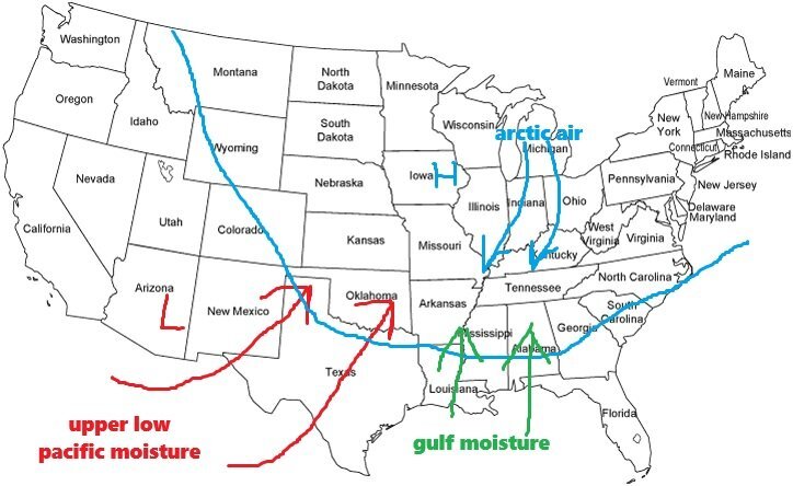
 This evening, I'll provide an update. I just examined the Canadian, Euro, and Euro AI models. Which I just subscribed to on a trial basis. The accumulation prediction is currently under question because the GFS is the outlier. For a significant portion of Kentucky, the most recent GFS shows virtually no snowfall. It has been going back and forth. As we get closer, it might align with the others. The remaining models are essentially all in favor of Kentucky experiencing significant snow accumulations.Mostly rain tomorrow. Maybe a light mix early.This is the setup that will bring the impactful winter storm this weekend. Additionally, the south and southeast will experience a devastating ice storm. The low is an upper-level low that will bring warm moisture that will override the arctic air mass, brought in by the high-pressure system, that will fall as snow over Kentucky.
 In my next update I may issue a BGP Winter Weather Alert.I just received these from the NWS-Louisville office. Confidence is now high that an impactful winter storm will affect our area.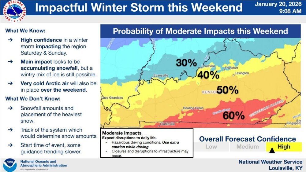
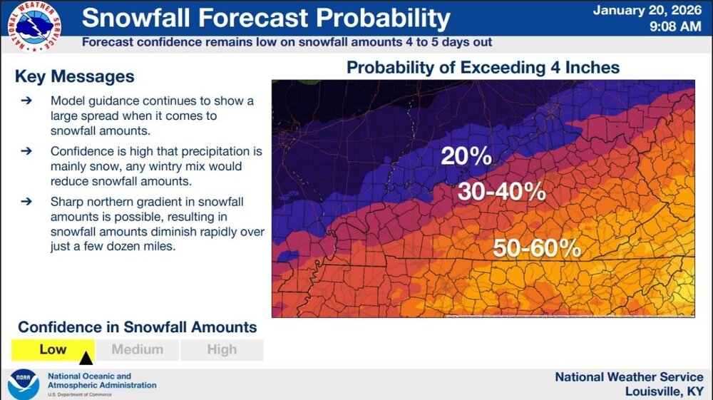
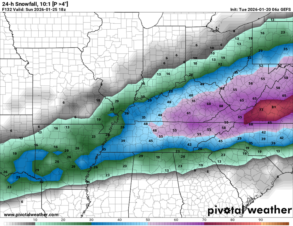
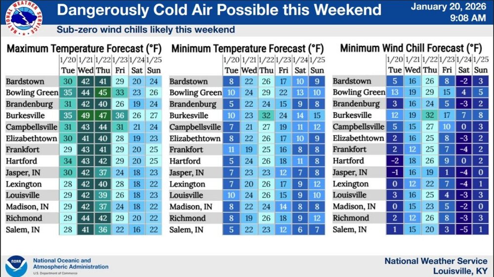 This is what the GEFS Ensemble is showing. It has 21 different members; I think I had posted 51 earlier. They all run a different scenario. Then it averages out the runs to produce the following maps. This is the model I started using last week to see if there was a signal for possible snow accumulation. It shows the chance in percentage of more than 1 inch accumulation. The second one shows the percentage chance of more than 4 inches of accumulation. Going by this, the Ohio Valley has a good chance of snow accumulation. Some a good chance of over 4 inches. I'll post an update after the 12z (7 am EST) run is released.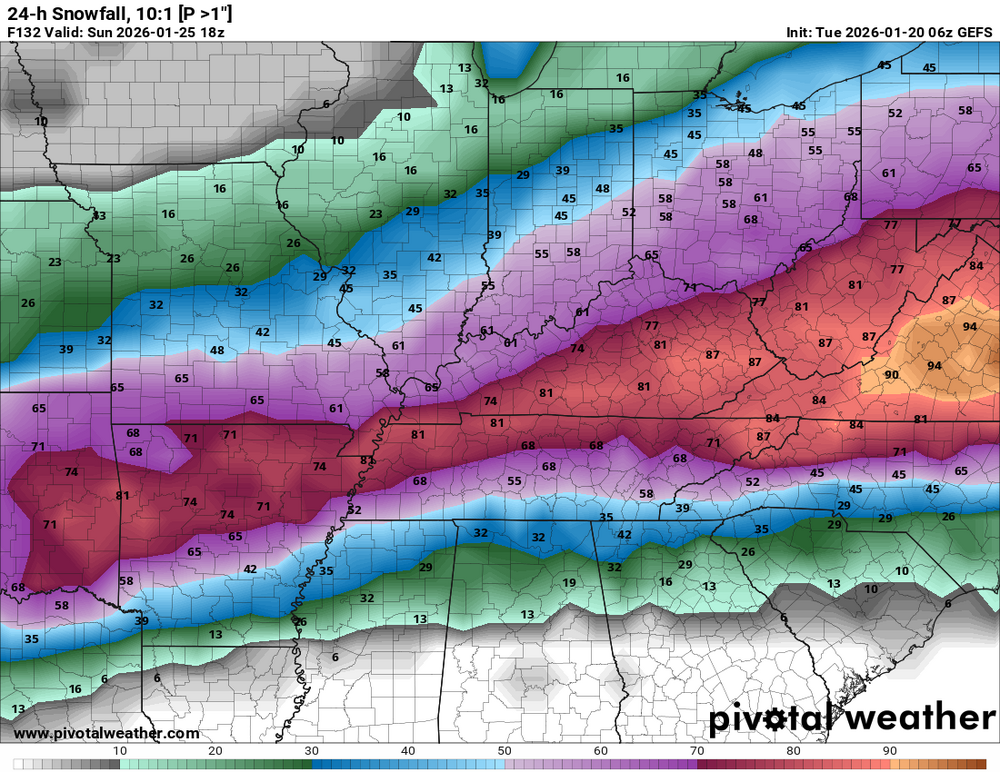

.png.f65b836be799a4975dbabf9a5c303e60.png)

.png.b21d86a0e9cbfb5df841d12e883ee093.png)



.png.98ee4bd0528a99473f6f3f1386464582.png)

.png.eb071c2f56477326a58a0a04e7a10db4.png)


.thumb.png.7bf5b8739bad1fdedf0de9011c2a046b.png.22ea8f7aa26e4dae3cc26ace8c4dedc8.png)


