.png.ffa34568722b20f38e3c3ecfcb9a2cd2.png)

.jpg.67ca52c6df25163f3af009c91bda1717.jpg)
nWo
-
Posts
25,586 -
Joined
-
Last visited
-
Days Won
2
5 Followers

Recent Profile Visitors
17,139 profile views


-
.thumb.jpg.d475a671bdc851f901dea439c04b8f9d.jpg) nWo changed their profile photo
nWo changed their profile photo -
WKU will close it's campus at 1 pm CDT
-
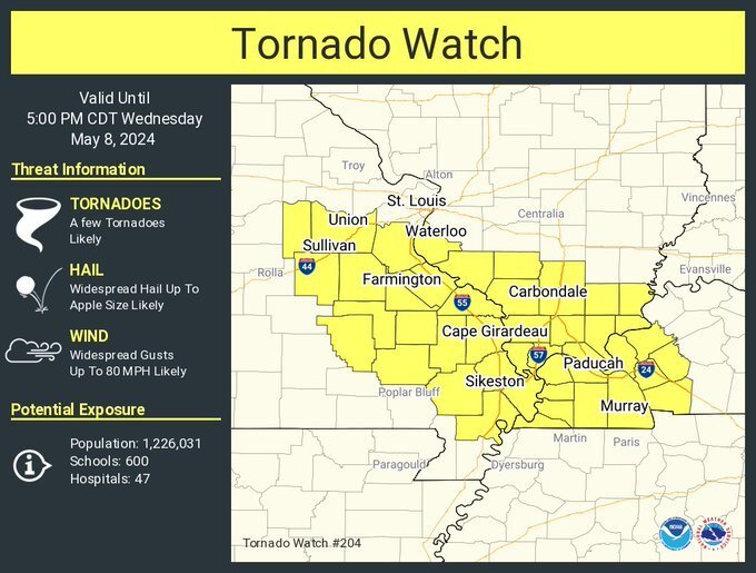
URGENT - IMMEDIATE BROADCAST REQUESTED Tornado Watch Number 204 NWS Storm Prediction Center Norman OK 1025 AM CDT Wed May 8 2024 The NWS Storm Prediction Center has issued a * Tornado Watch for portions of Southern Illinois Western Kentucky Southeastern Missouri * Effective this Wednesday morning and afternoon from 1025 AM until 500 PM CDT. * Primary threats include... A few tornadoes likely with a couple intense tornadoes possible Widespread large hail and scattered very large hail events to 3 inches in diameter likely Widespread damaging winds and isolated significant gusts to 80 mph likely SUMMARY...A supercell cluster in Missouri will likely persist through the afternoon while spreading east-southeastward toward southern Illinois, southeastern Missouri and western Kentucky, with some potential for additional storm development this afternoon. The environment will become more favorable for surface-based storms capable of producing tornadoes (a couple of which could be strong/EF2+), severe wind swaths up to 80 mph, and very large hail of 2-3 inches in diameter. The tornado watch area is approximately along and 45 statute miles north and south of a line from 5 miles south of Vichy MO to 40 miles east of Paducah KY. For a complete depiction of the watch see the associated watch outline update (WOUS64 KWNS WOU4). PRECAUTIONARY/PREPAREDNESS ACTIONS... REMEMBER...A Tornado Watch means conditions are favorable for tornadoes and severe thunderstorms in and close to the watch area. Persons in these areas should be on the lookout for threatening weather conditions and listen for later statements and possible warnings.

-
Some school systems are starting to dismiss schools early today.
-
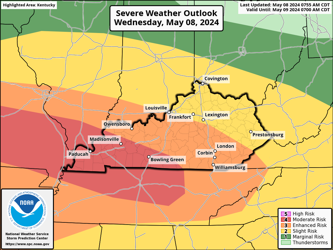
The level 4 Moderate Risk area now includes Madisonville and Bowling Green.
-
Clouds are breaking here in Richmond.
-
I figured I would verify today's cloud cover later. Recall from yesterday's conference call that things will get lot worse if there is any clearing or sunshine. Today's covered time frame is from 10 a.m. to 8 p.m. EDT.
-
Here are two new maps. The first is a significant tornado map. A majority of significant tornadoes (F2 or greater damage) have been associated with STP values greater than 1 within an hour of their occurrence. You can see 4s and 5s for most of Kentucky. This next one is the violent tornado map. Research using observed soundings found that 0-3 km CAPE and 0-3 km lapse rate were notable discriminators of violent tornado environments (verses weak and/or significant tornado environments). The 0-3 km CAPE is what I shorten to 3cape when I talk about it in my posts. It is showing 5s and 6s. With the indicated numbers, both maps show. I fully expect tornado watches to be issued later today.
-
This new map shows the possible hail size. The SARS method returns a maximum expected hail report by matching existing environmental conditions to historic severe hail cases. These forecast maximum sizes are conditional on severe hail of any size occurring. This graphic shows the "best guess" maximum hail report.
-
This watch has expired.
-
Just received this from the NWS-Louisville office:
-
URGENT - IMMEDIATE BROADCAST REQUESTED Tornado Watch Number 201 NWS Storm Prediction Center Norman OK 155 AM CDT Wed May 8 2024 The NWS Storm Prediction Center has issued a * Tornado Watch for portions of Extreme southern Illinois Western and west-central Kentucky Extreme southeastern Missouri * Effective this Wednesday morning from 155 AM until 600 AM CDT. * Primary threats include... A couple tornadoes possible Isolated damaging wind gusts to 70 mph possible Isolated large hail events to 1.5 inches in diameter possible SUMMARY...A few more hours of severe-thunderstorm threat remains across this region in a favorable environment for damaging gusts and tornado potential, but messy storm modes. The tornado watch area is approximately along and 35 statute miles north and south of a line from 40 miles west southwest of Paducah KY to 20 miles north northeast of Bowling Green KY. For a complete depiction of the watch see the associated watch outline update (WOUS64 KWNS WOU1). PRECAUTIONARY/PREPAREDNESS ACTIONS... REMEMBER...A Tornado Watch means conditions are favorable for tornadoes and severe thunderstorms in and close to the watch area. Persons in these areas should be on the lookout for threatening weather conditions and listen for later statements and possible warnings.
-
From sections of the Ohio, Tennessee, and mid-Mississippi valleys into the southern Plains, numerous severe thunderstorms seem likely on Wednesday. All extreme risks are possible, including as tornadoes, large to extremely large hail, and possibly extremely damaging winds. There could be some powerful tornadoes. There is still a chance for a complicated but potentially large severe weather episode throughout a large area that stretches from the ArkLaTex area into portions of the mid-MS, OH, and TN Valleys. There will be a chance of strong tornadoes, large to gigantic hail, and destructive winds in broad swaths. All severe hazards will be possible. This morning, a highly moist and unstable warm sector is expected to be present across portions of Oklahoma and Texas, as well as extend eastward and southward along a warm front into the Tennessee, lower Ohio, and mid-Mississippi valleys. Through the day and into the evening, a potentially volatile severe thunderstorm environment will be supported by moderate to strong deep-layer shear and strong to extreme instability, which is enhanced by a plume of midlevel lapse rates migrating eastward from the Plains. Based on these data, the Storm Prediction Center has designated a portion of Kentucky as level 4 Moderate Risk, which is southwest of a line that runs from just south of Madisonville to Bowling Green. Level 3 Enhanced Risk of Severe Storms covers the remaining portion of the state. Except for the Cincinnati/NKY area.
-
The sun is already starting to come back out here in Richmond.
-
Everyone should be weather-aware later today into early Thursday morning. Have more than one way to get information for your area. This will be our weather motto: FOREWARNED is FOREARMED. (If you know about a problem or situation in advance, you will be able to deal with it when you need to.)