

nWo
BGP Meteorologist
-
Joined
-
Last visited
Everything posted by nWo
-
-
I have checked the 00z GFS; it has moved more towards the Euro. I still want to see another run or two to see if this trend continues.
-
Starting around 72 hours before a weather event is when you can start to getting a good read.
-
I just checked the 18z run of the GFS. It is back to showing snow coming into Kentucky. I'm going to wait and see a couple more runs to see if it stays consistent before I trust it.
-
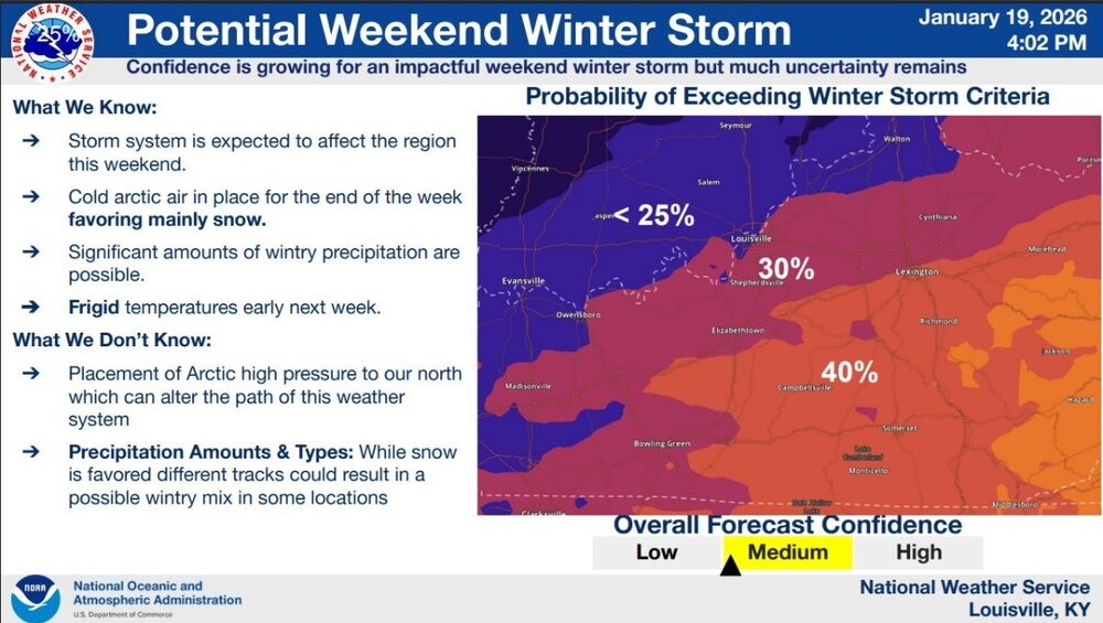
I received this from the NWS-Louisville office.
-
The one model that has been consistent in the last couple of runs is the euro. It has been showing Kentucky receiving a good amount of snow. Even though the GFS is the one that really has been an outlier. The GEFS is showing a good chance of snow for Kentucky. Confidence is growing in this possible winter storm.
-
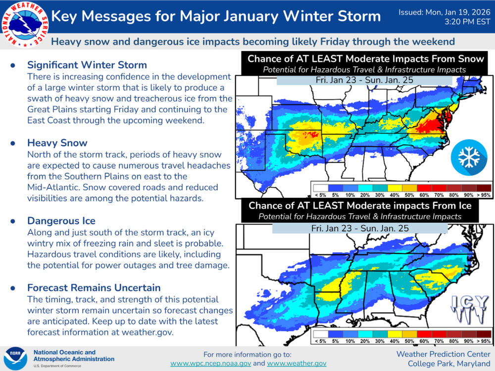
This is what the Weather Prediction Center just issued.
-
That would go with what the Euro is showing.
-
URGENT - WEATHER MESSAGE National Weather Service Wilmington OH 803 AM EST Mon Jan 19 2026 INZ066-073>075-080-KYZ089>100-OHZ063>065-070>074-077>082-088-192115- /O.CON.KILN.CW.Y.0001.260119T2200Z-260120T1500Z/ Franklin-Ripley-Dearborn-Ohio-Switzerland-Carroll-Gallatin-Boone- Kenton-Campbell-Owen-Grant-Pendleton-Bracken-Robertson-Mason- Lewis-Fayette-Pickaway-Fairfield-Butler-Warren-Clinton-Ross- Hocking-Hamilton-Clermont-Brown-Highland-Adams-Pike-Scioto- Including the cities of Portsmouth, Bright, Augusta, Milan, Oakbrook, Mount Olivet, Pickerington, Rising Sun, Fort Thomas, Wilmington, Franklin, Chillicothe, Mason, Brooksville, Maysville, Springboro, Seaman, Williamstown, Hillsboro, Circleville, Mulberry, Tollesboro, Georgetown, Butler, Vevay, Versailles, Aberdeen, Crittenden, Florence, Downtown Cincinnati, Bellevue, Winchester, Manchester, Wheelersburg, Day Heights, Newport, Batesville, Head Of Grassy, Lawrenceburg, Hamilton, Landen, Peebles, Waverly, Fairfield, Dillsboro, Washington Court House, Summerside, Independence, Warsaw, Dayton, Withamsville, Brookville, Hidden Valley, Osgood, Vanceburg, Alexandria, Ripley, Erlanger, Mount Carmel, Middletown, West Union, Oxford, Greenfield, Highland Heights, Burlington, Covington, Mount Orab, Lancaster, Aurora, Lebanon, Mount Repose, Camp Dix, Carrollton, Dry Ridge, Falmouth, Pike Lake, Greendale, Logan, Piketon, Owenton, Blanchester, and Milford 803 AM EST Mon Jan 19 2026 ...COLD WEATHER ADVISORY REMAINS IN EFFECT FROM 5 PM THIS AFTERNOON TO 10 AM EST TUESDAY... * WHAT...Very cold wind chills as low as 10 below zero expected. * WHERE...Portions of southeast Indiana, northeast and northern Kentucky, and central, south central, and southwest Ohio. * WHEN...From 5 PM this afternoon to 10 AM EST Tuesday. * IMPACTS...The cold wind chills as low as 10 below zero could result in hypothermia if precautions are not taken. PRECAUTIONARY/PREPAREDNESS ACTIONS... Dress in layers including a hat, face mask, and gloves if you must go outside.
-
URGENT - WEATHER MESSAGE National Weather Service Louisville KY 157 AM EST Mon Jan 19 2026 INZ079-KYZ031>037-039>043-048-049-192100- /O.NEW.KLMK.CW.Y.0001.260120T0300Z-260120T1500Z/ Jefferson IN-Oldham-Trimble-Henry-Shelby-Franklin-Scott KY- Harrison KY-Anderson-Woodford-Fayette-Bourbon-Nicholas-Jessamine- Clark KY- Including the cities of La Grange, Madison, Lexington, Shelbyville, Nicholasville, Versailles, New Castle, Winchester, Bedford, Lawrenceburg, Carlisle, Georgetown, Frankfort, Milton, Paris, and Cynthiana 157 AM EST Mon Jan 19 2026 ...COLD WEATHER ADVISORY IN EFFECT FROM 10 PM THIS EVENING TO 10 AM EST TUESDAY... * WHAT...Very cold wind chills as low as 3 to 6 below zero expected. * WHERE...Portions of Indiana and east central and north central Kentucky. * WHEN...From 10 PM this evening to 10 AM EST Tuesday. * IMPACTS...Frostbite and hypothermia will occur if unprotected skin is exposed to these temperatures. PRECAUTIONARY/PREPAREDNESS ACTIONS... Use caution while traveling outside. Wear appropriate clothing, a hat, and gloves. Keep pets indoors as much as possible.
-
-
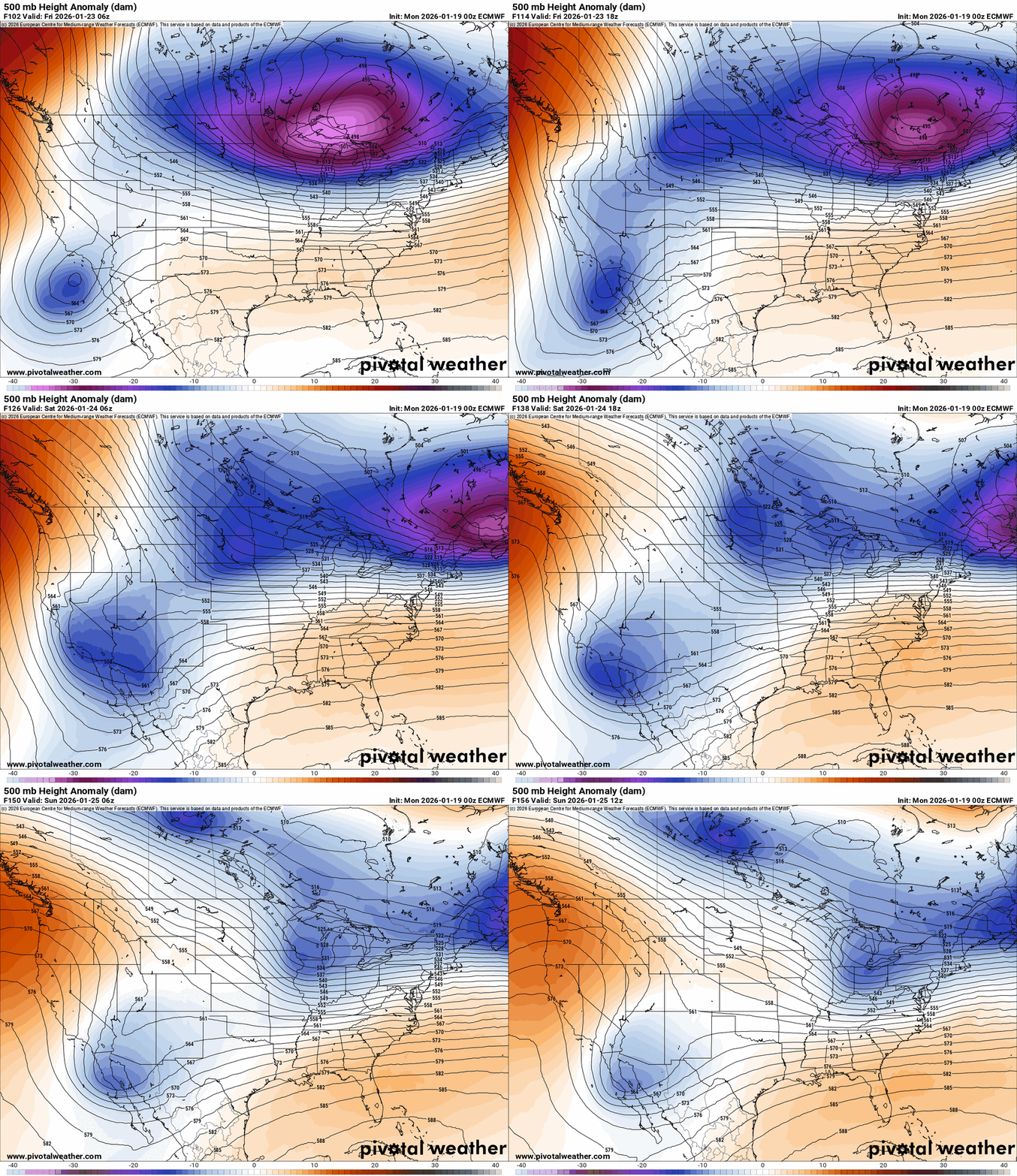
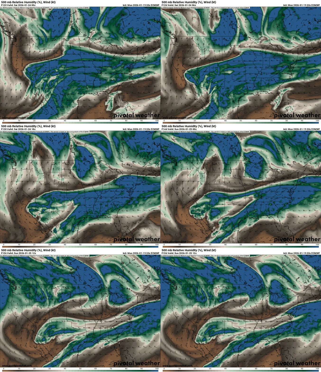
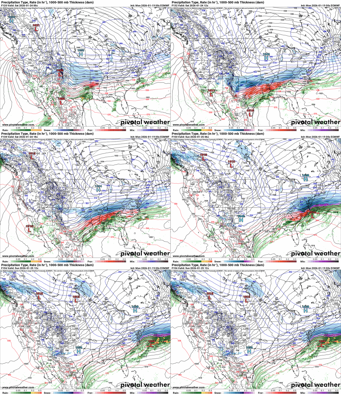
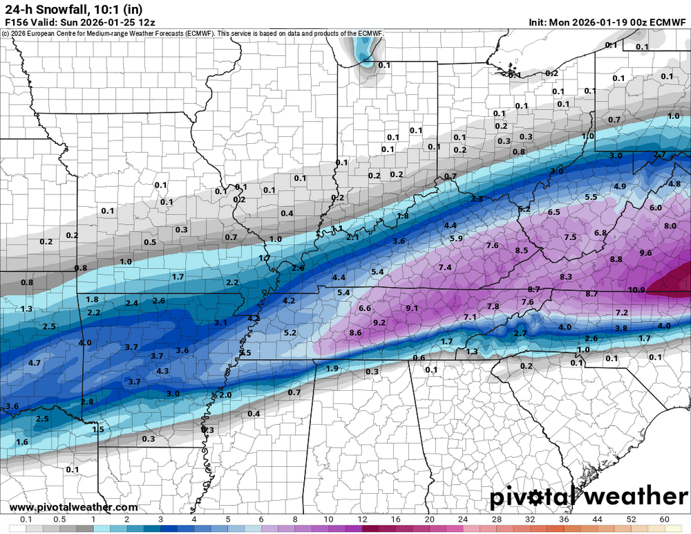
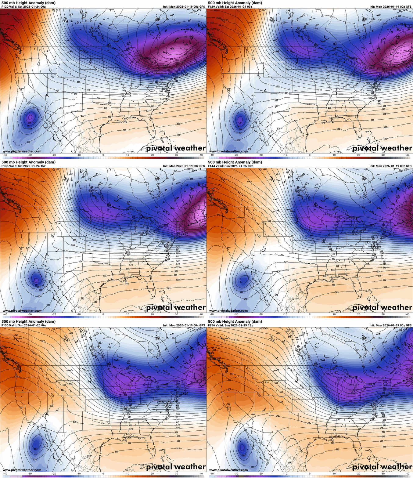
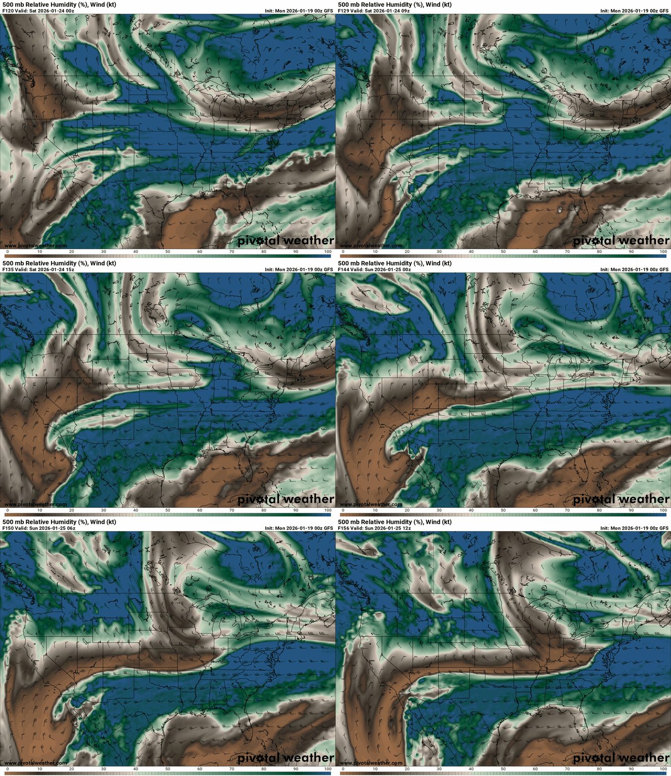
This is my first in-depth examination of a potential system that might provide Kentucky with the biggest snowfall this winter. The accumulation total and potential snowfall locations are uncertain because there are still many discrepancies between the models. First, on Friday morning, there will be a chance of arctic air entering our region. The mid-20s will be the starting point for temperatures, which will largely remain there until Friday night. On Friday night, we'll witness them drop into their mid-teens. The temperature on Saturday will drop to the single digits as the arctic air gets deeper. On Saturday night, the temperature will rise into the mid-20s. An upper-level low off the coast of California is crucial to the potential snowstorm. This is where the models differ from one another. The Arctic air is bringing warm Gulf moisture during the day on Friday, which is why the Euro has this low phase. Root for this model to see potential larger snow accumulations. In the event that this happens, snowfall will begin on Friday night and last for the majority of Saturday. Those on the northern edge are another thing to be wary of. Higher totals for your area could result from this event moving northward. If the track does shift northward, then some in Kentucky could see an ice storm. The GFS, on the other hand, shows a glancing blow for Kentucky, with less upper-level low phasing and only snow accumulation in eastern Kentucky. This is due to the fact that, unlike the Euro, this model does not phase the upper-level low. It is demonstrating that some, but not much, moisture is being introduced into the system. I'm watching this closely and will post updates as we get closer. First I’m showing the maps from the Euro. Upper-level moisture showing the phasing. You need moisture at this level for snow. This is what the Euro is showing for possible 24-hour snow accumulations. I post this map as an illustration of what we could see. Don't take this as my call for snow just yet. This is what the GFS is showing.
.thumb.png.93c727a78e1e5eec05872b4d48dec3d3.png)
.thumb.png.3d865c58dfa14dd811aa7205c5375bc0.png)
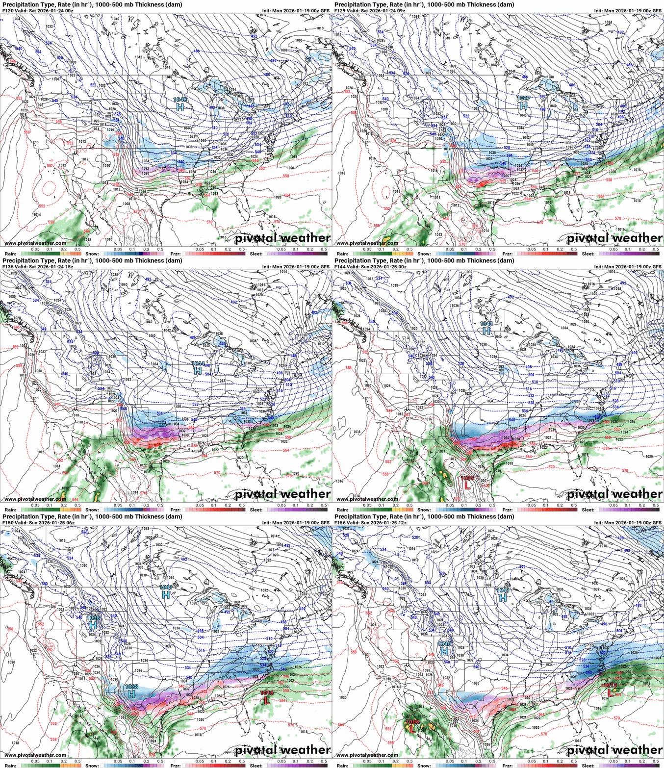
.thumb.png.303a5e74aebf5ca7887f72f5de23bb8e.png)
-
I'm hesitating from posting what the GFS and Euro are showing because they have been waffling back and forth on this possible event. One time they show a crippling snow accumulation. Then all rain. Then rain/sleet/ice/snow. But the GFS Ensemble is showing signals of accumulating snow next weekend. I will try to post a more detailed forecast soon.
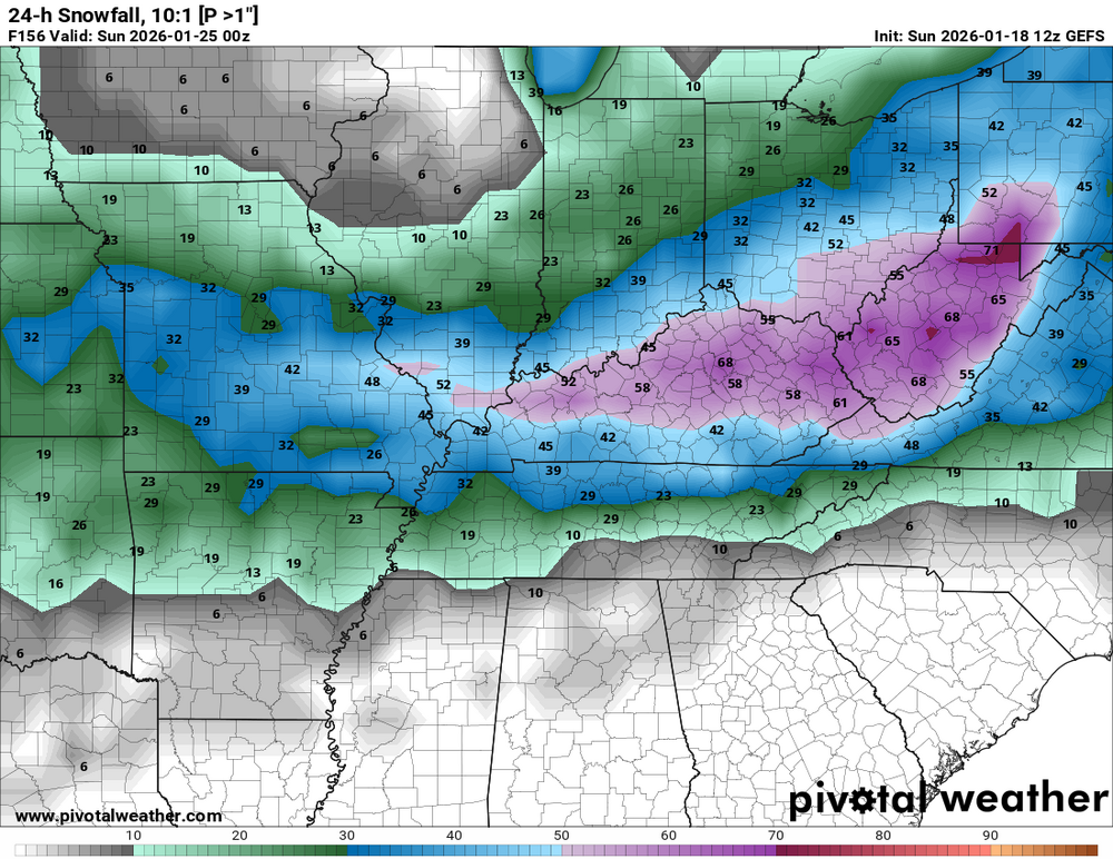
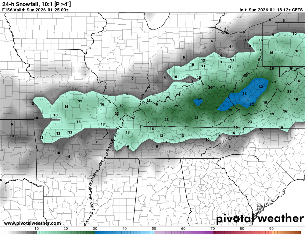
-
I neglected to mention that I obtained my certificate for the hand analysis course with the Weather Academy. That is the reason you may see more hand-drawn analyses from me in my weather forecasts.
-
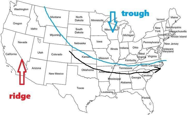
A trough is an extended area of low pressure where air rises, creating cooler, cloudier, and frequently wetter conditions, whereas a ridge is an extended area of high pressure where air sinks, resulting in warm, dry, and sunny weather. You can picture this by imagining the jet stream as a wave. Ridges are the upward humps that promote stability, and troughs are the downward dips that bring unsettled weather. Our weather has been locked into this pattern for most of winter. This means the winds that direct our weather have been mostly in a zonal flow (black arrow). For Kentucky to have a big snow, we need the ridge in the west to break down. This will allow a trough to deepen and dig further to the south. A weather system will ride in the area where the trough and ridge meet. Under the setup we are in, it is causing a zonal flow, so a system will ride out into the Atlantic. Also, it may not phase with moisture from the Gulf. The date from the long-range climate forecast model for February suggests that this configuration might be failing, in my opinion. The western ridge might begin to break down. More arctic air may be able to travel southward as a result, and any system that develops may be able to absorb more warm Gulf moisture. This far in the future it is impossible to predict any winter system that could bring any major or more accumulation of snow. I just think February is a month that could be interesting.
-
Yes, we may see some this week. According to the Climate Forecast Model, February could be interesting.
-
This event has been canceled.
-
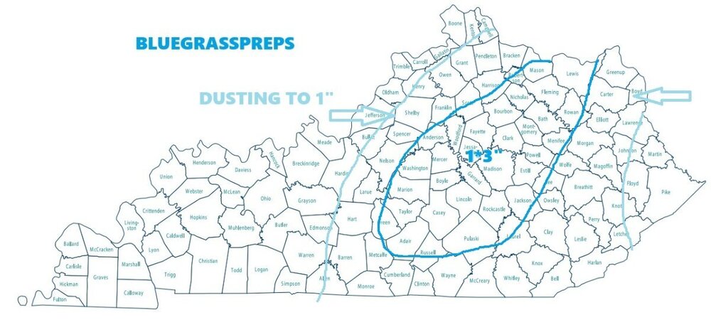
Stay safe if you are heading out. This Winter Weather Advisory covers a quick but impactful system moving through the Commonwealth. Here is the breakdown of what to expect tonight and into the weekend: Timing & Accumulation • Advisory Duration: 7:00 PM EST Friday to 7:00 AM EST Saturday. • Main Impacts: Light snow will transition from a rain/snow mix this evening, with the most persistent bands moving through central and eastern Kentucky overnight. • Accumulation: Generally, 1 to 2 inches, though some higher elevations or areas under intense "snow squalls" could see locally higher amounts. Key Hazards • Snow Squalls: Be alert for "bursts" of heavy snow. These can cause a flash freeze on roads and drop visibility to near zero in seconds. • Slippery Roads: With temperatures dropping into the 20s, any wet pavement will quickly turn to ice (black ice). Bridges and overpasses will freeze first. • Bitter Cold: Once the snow moves out on Saturday, an Arctic front arrives. Expect wind chills to drop into the single digits by Sunday morning.
-
URGENT - WINTER WEATHER MESSAGE National Weather Service Jackson KY 139 PM EST Fri Jan 16 2026 KYZ044-050>052-058>060-068-069-170300- /O.NEW.KJKL.WW.Y.0002.260117T0000Z-260117T1200Z/ Fleming-Montgomery-Bath-Rowan-Estill-Powell-Menifee-Rockcastle- Jackson- Including the cities of Morehead, Camargo, Flemingsburg, Clay City, Annville, Frenchburg, Mount Sterling, Owingsville, McKee, Irvine, Ravenna, Jeffersonville, Mount Vernon, Brodhead, and Stanton 139 PM EST Fri Jan 16 2026 ...WINTER WEATHER ADVISORY IN EFFECT FROM 7 PM THIS EVENING TO 7 AM EST SATURDAY... * WHAT...Snow expected. Total snow accumulations up to one inch in the valleys and up to 2 inches toward ridgetops. * WHERE...Portions of east central, south central, and southeast Kentucky. * WHEN...From 7 PM this evening to 7 AM EST Saturday. * IMPACTS...Plan on slippery road conditions. * ADDITIONAL DETAILS...Precipitation will begin primarily as rain, or mix with rain at times, before changing to all snow before ending. Snow accumulations will favor elevated and grassy surfaces. PRECAUTIONARY/PREPAREDNESS ACTIONS... Slow down and use caution while traveling. The latest road conditions for Kentucky can be found by visiting https://goky.ky.gov.
-
URGENT - WINTER WEATHER MESSAGE National Weather Service Wilmington OH 1251 PM EST Fri Jan 16 2026 KYZ094>100-OHZ064-065-073-074-079>082-088-170200- /O.NEW.KILN.WW.Y.0002.260117T0000Z-260117T1200Z/ Owen-Grant-Pendleton-Bracken-Robertson-Mason-Lewis-Pickaway- Fairfield-Ross-Hocking-Brown-Highland-Adams-Pike-Scioto- Including the cities of Augusta, Brooksville, Waverly, Aberdeen, Vanceburg, West Union, Head Of Grassy, Tollesboro, Owenton, Georgetown, Wheelersburg, Manchester, Falmouth, Seaman, Maysville, Circleville, Lancaster, Pike Lake, Greenfield, Chillicothe, Mount Orab, Portsmouth, Dry Ridge, Pickerington, Williamstown, Peebles, Piketon, Butler, Ripley, Logan, Mount Olivet, Camp Dix, Crittenden, Hillsboro, and Winchester 1251 PM EST Fri Jan 16 2026 ...WINTER WEATHER ADVISORY IN EFFECT FROM 7 PM THIS EVENING TO 7 AM EST SATURDAY... * WHAT...Snow expected. Total snow accumulations of one to three inches. * WHERE...Portions of northeast and northern Kentucky and central, south central, and southwest Ohio. * WHEN...From 7 PM this evening to 7 AM EST Saturday. * IMPACTS...Plan on slippery road conditions. The hazardous conditions could impact the Friday evening commute. PRECAUTIONARY/PREPAREDNESS ACTIONS... Slow down and use caution while traveling. In Kentucky, visit goky.ky.gov for the latest road information. In Ohio, visit ohgo.com for the latest road information.
-
URGENT - WINTER WEATHER MESSAGE National Weather Service Louisville KY 142 PM EST Fri Jan 16 2026 KYZ033>043-045>049-054>057-064>067-077-078-170900- /O.NEW.KLMK.WW.Y.0002.260117T0000Z-260117T1200Z/ Henry-Shelby-Franklin-Scott KY-Harrison KY-Spencer-Anderson- Woodford-Fayette-Bourbon-Nicholas-Nelson-Washington KY-Mercer- Jessamine-Clark KY-Marion-Boyle-Garrard-Madison-Green-Taylor- Casey-Lincoln-Adair-Russell- Including the cities of Winchester, Versailles, Bardstown, Lancaster, Lawrenceburg, Stanford, Springfield, Taylorsville, Harrodsburg, Lebanon, Frankfort, Shelbyville, Paris, Danville, Lexington, Greensburg, Liberty, New Castle, Cynthiana, Richmond, Nicholasville, Georgetown, Carlisle, Campbellsville, Columbia, and Jamestown 142 PM EST Fri Jan 16 2026 /1242 PM CST Fri Jan 16 2026/ ...WINTER WEATHER ADVISORY IN EFFECT FROM 7 PM EST /6 PM CST/ THIS EVENING TO 7 AM EST /6 AM CST/ SATURDAY... * WHAT...Snow expected. Total snow accumulations of one to two inches. * WHERE...Portions of east central, north central, and south central Kentucky. * WHEN...From 7 PM EST /6 PM CST/ this evening to 7 AM EST /6 AM CST/ Saturday. * IMPACTS...Plan on slippery road conditions. PRECAUTIONARY/PREPAREDNESS ACTIONS... Slow down and use caution while traveling. For Kentucky Road Conditions please visit http://goky.ky.gov
.thumb.png.21d7518e4409ef90bcf08dc3d5b8ff3d.png)
-
-
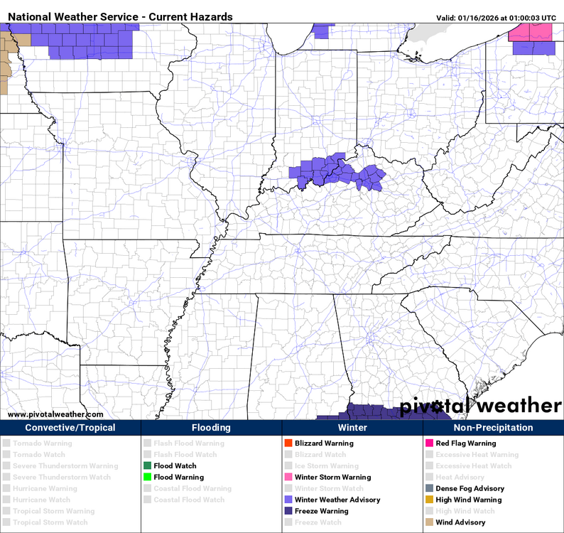
URGENT - WINTER WEATHER MESSAGE National Weather Service Louisville KY 346 PM EST Thu Jan 15 2026 INZ076>079-083-084-089>092-KYZ030>037-040>043-049-161015- /O.NEW.KLMK.WW.Y.0001.260116T0900Z-260116T1500Z/ Orange-Washington IN-Scott IN-Jefferson IN-Dubois-Crawford-Perry- Harrison IN-Floyd-Clark IN-Jefferson-Oldham-Trimble-Henry-Shelby- Franklin-Scott KY-Harrison KY-Woodford-Fayette-Bourbon-Nicholas- Clark KY- Including the cities of Corydon, Scottsburg, Georgetown, La Grange, Frankfort, Winchester, New Castle, Jeffersonville, Versailles, Paoli, Carlisle, Lexington, Salem, Louisville, Shelbyville, English, Paris, Jasper, Milton, Tell City, Cynthiana, Madison, New Albany, and Bedford 346 PM EST Thu Jan 15 2026 /246 PM CST Thu Jan 15 2026/ ...WINTER WEATHER ADVISORY IN EFFECT FROM 4 AM EST /3 AM CST/ TO 10 AM EST /9 AM CST/ FRIDAY... * WHAT...Snow showers are expected to cause negative travel impacts to the Friday morning commute hours. Minor snow accumulations less than one inch expected. * WHERE...Portions of southern Indiana and north central Kentucky along and north of I-64. * WHEN...From 4 AM EST /3 AM CST/ to 10 AM EST /9 AM CST/ Friday. * IMPACTS...Plan on slippery road conditions. The hazardous conditions could impact the Friday morning commute. PRECAUTIONARY/PREPAREDNESS ACTIONS... Slow down and use caution while traveling. In Indiana, for Indiana Road Conditions please visit http://511in.org In Kentucky, for Kentucky Road Conditions please visit http://goky.ky.gov
-
On Friday morning, the first light snowfall is predicted to occur in southern Indiana and northern Kentucky between 4 and 10 AM EST. There is a high likelihood that there won't be much snowfall—between a dusting and half an inch. Slick spots may have an impact on the Friday morning commute, even in small amounts. There will be another snowfall on Friday night and into Saturday. Once more, some might notice a dusting to one. On Friday morning, there will be wind chills in the mid-teens and temperatures in the mid-20s. The starting temperature on Saturday should be in the low to mid-30s. The low 20s will be the range of windchills.
-
If you watch some weather forecasters on YouTube, you may see some posting about a significant snowstorm next week. So let me show what they may be talking about. Then I'm going to show you another map from the same GFS model. The first one is from yesterday afternoon's 18z run. It shows a possible blizzard for the Ohio Valley. If this were to come to pass, it would completely shut down the Ohio Valley. Now, this is what the same model was showing for the same time period on last evening's 00z run. The signal is there for possible snow next week. We'll just have to wait and see.
.thumb.png.ba97894020b2d3635cd9f79cc01d9d07.png)
.thumb.png.1f12a1efa78e80ba9196161b2d20d585.png)





.png.ff180ae96cd566422b67a880437dc15d.png)
.png.3716da9af319b6478aa050e03ee21ea1.png)


.png.63daf22af105a021def993d4169e25de.png)


.png.240aba407a9921f60afa81f7d77043ef.png)

.png.0f0aaf6ef979c8734a8e0fb253dabe6b.png)
.png.d12fb7b3e623aed71c6a4ebfc8048de6.png)