
nWo
BGP Meteorologist
-
Joined
-
Last visited
Everything posted by nWo
-
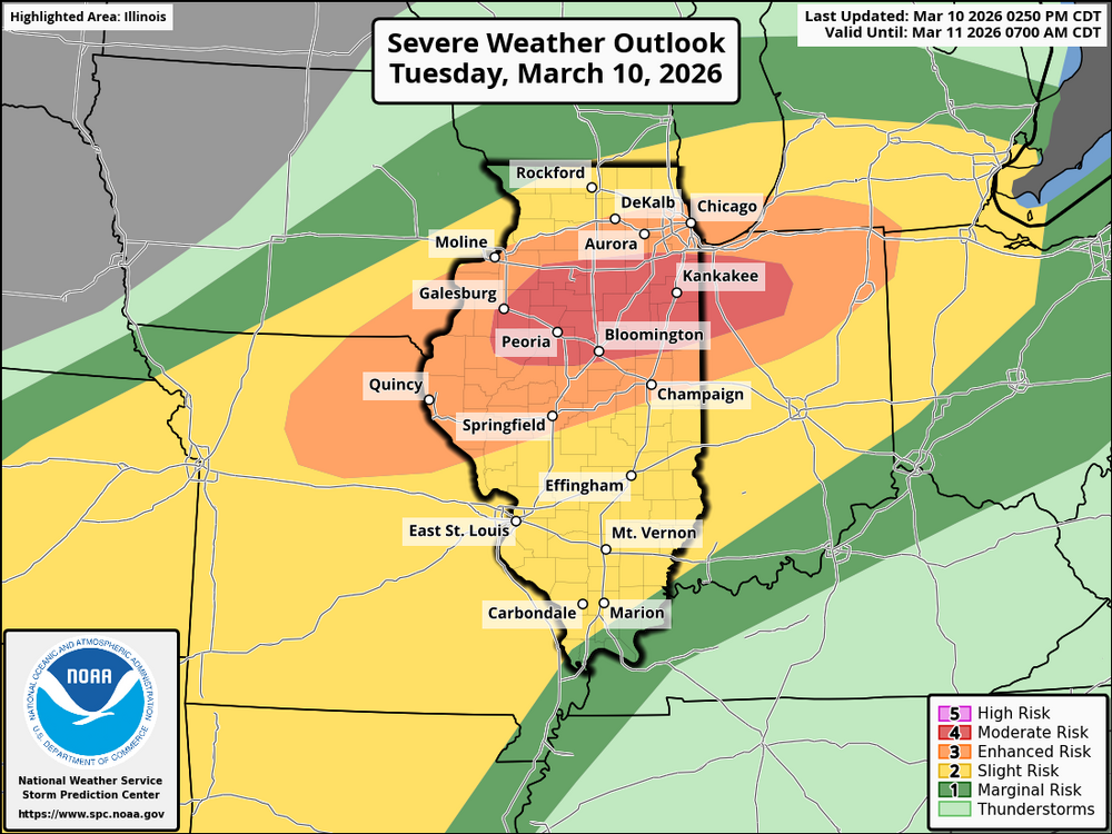
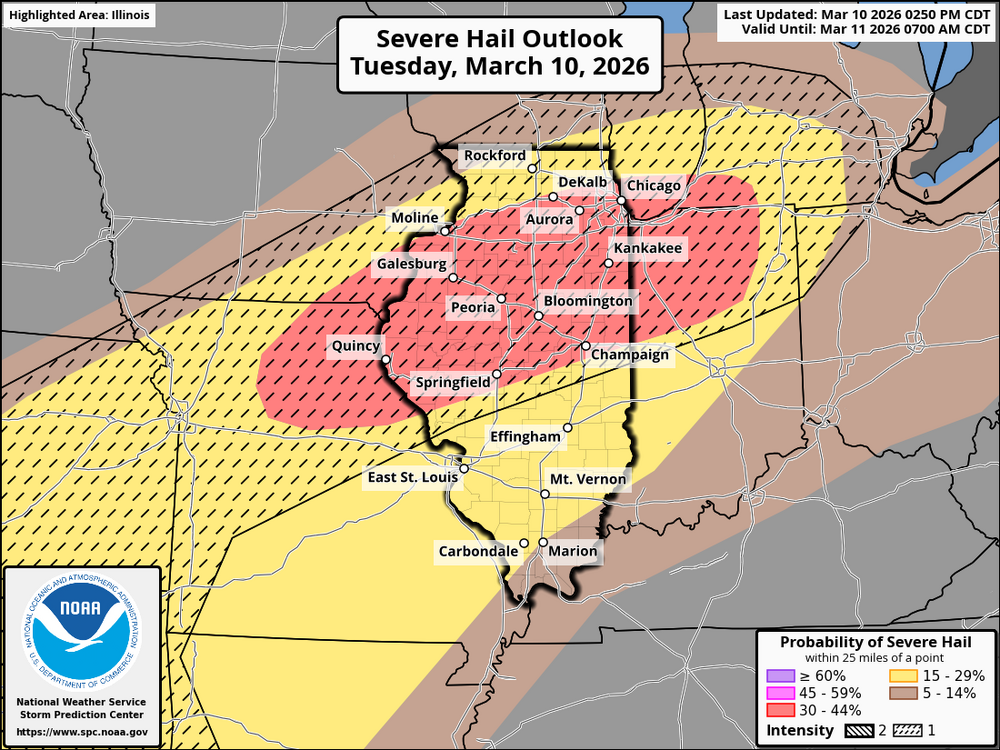
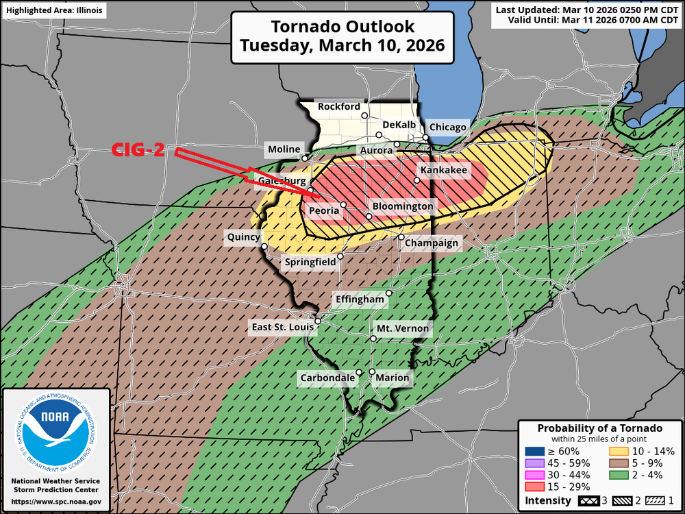
Massive tornado near Kankakee, IL, possible EF3-4 with golf ball-size hail.
-
It looks like a high-risk severe weather situation is unfolding across the Midwest, especially with supercell development expected this afternoon. Given the conditions—moderate to strong instability, deepening cumulus clouds, and favorable shear—there’s a very real threat of severe weather, including: Large hail (2+ inches in diameter) Strong to intense tornadoes (EF2-3+) (EF-3+ in CIG 2 area) Significant thunderstorms The timing of the severe weather is still somewhat uncertain, but it's expected to intensify over the next couple of hours. The tornado watch is imminent and will cover the region impacted by these hazards. If you're in the affected areas, make sure to stay updated through weather alerts and prepare for potential severe storms. Let me know if you'd like a more specific regional forecast.
-
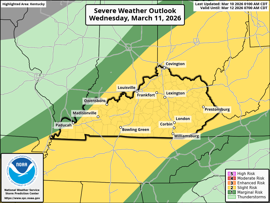
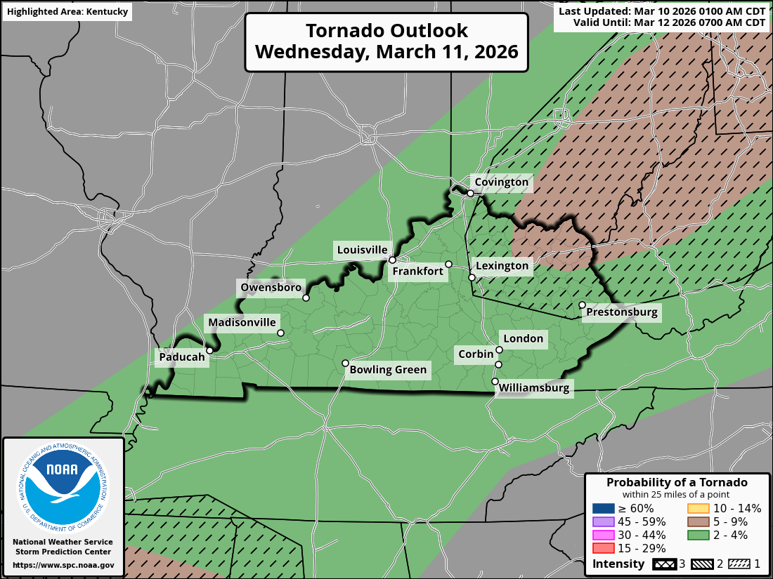
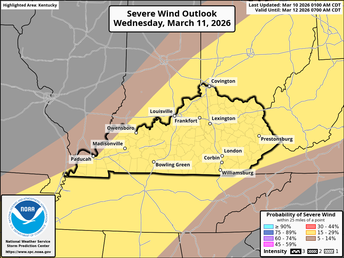
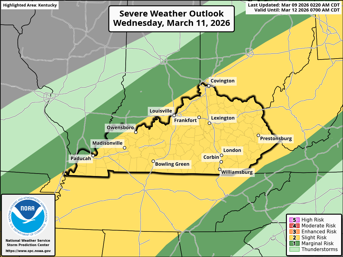
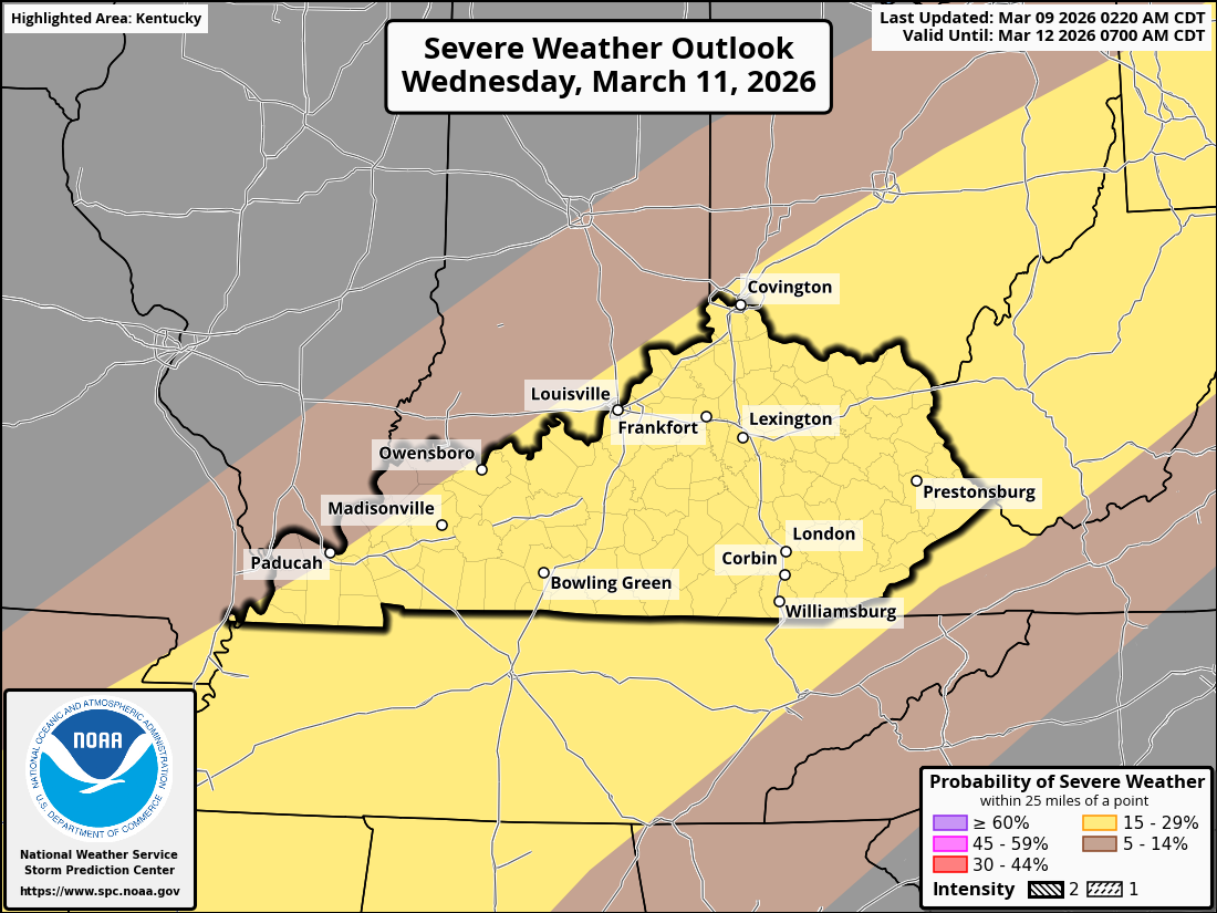
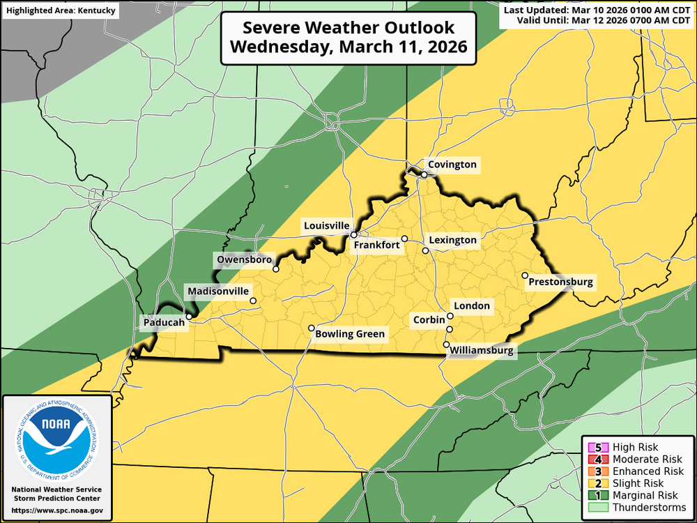
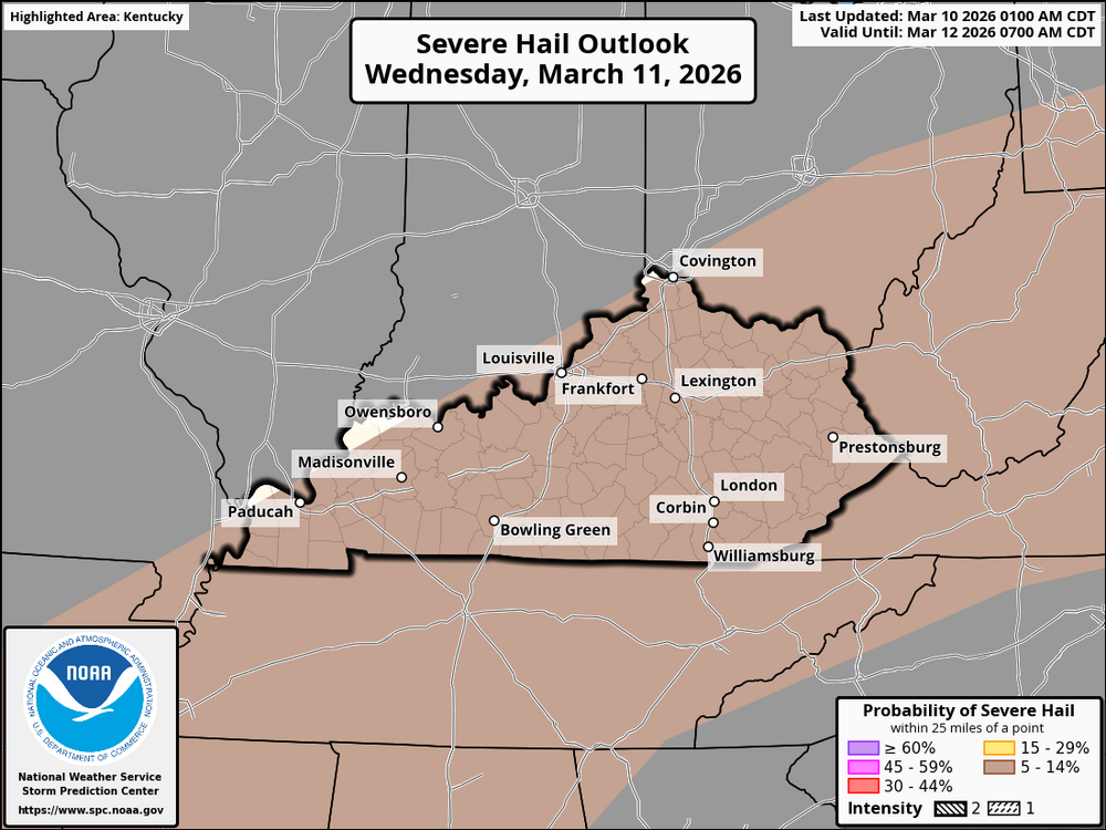
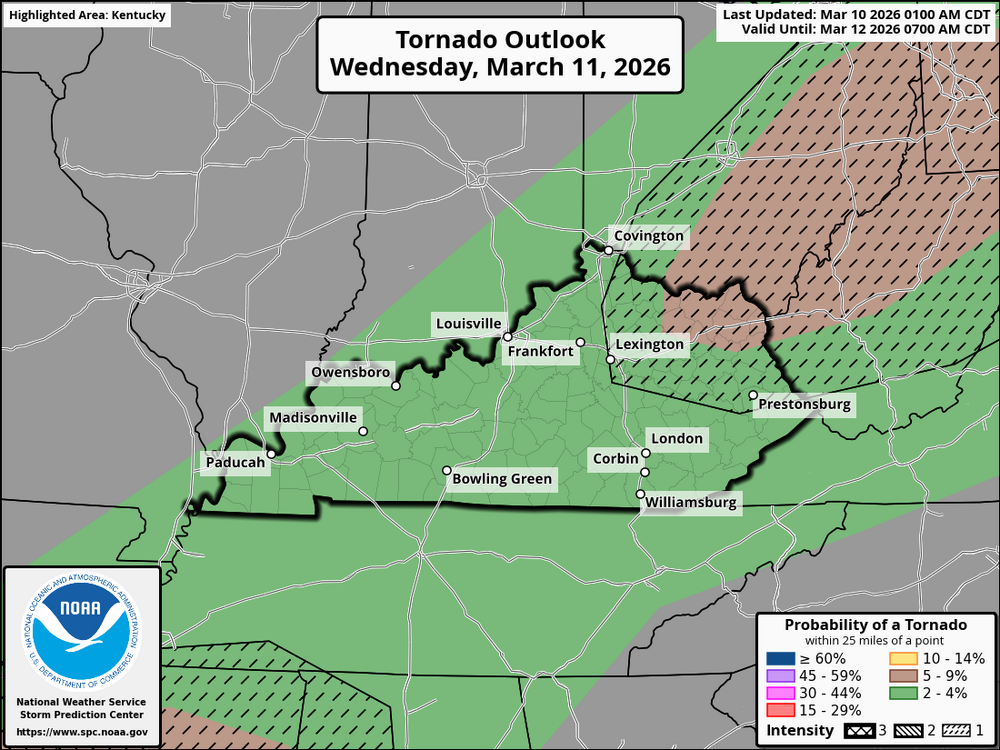
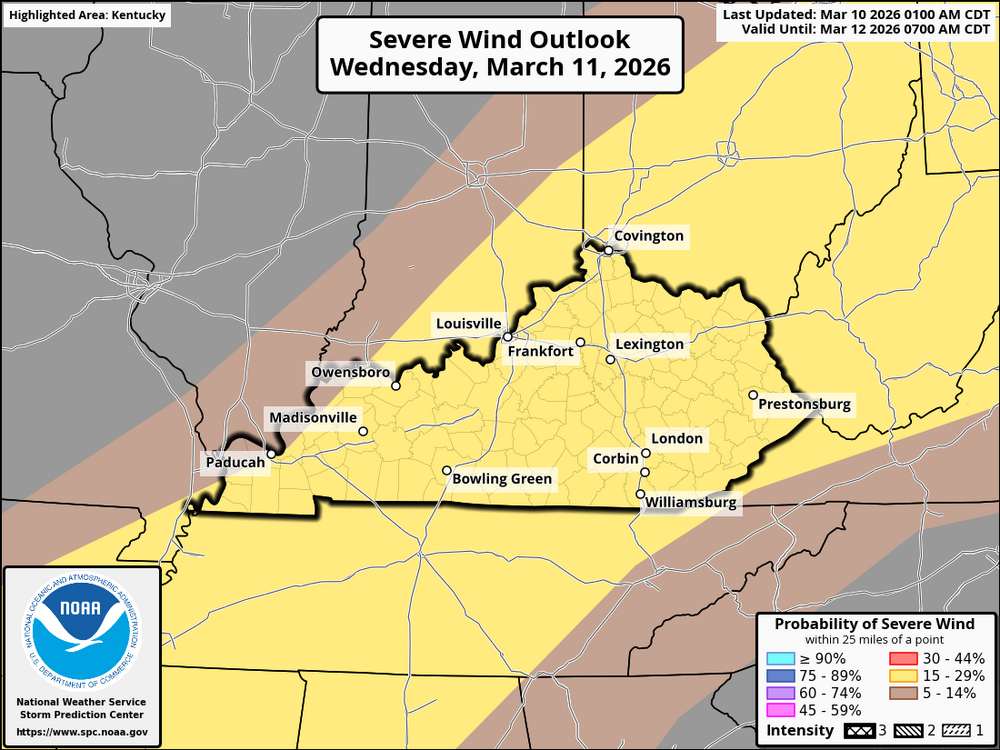
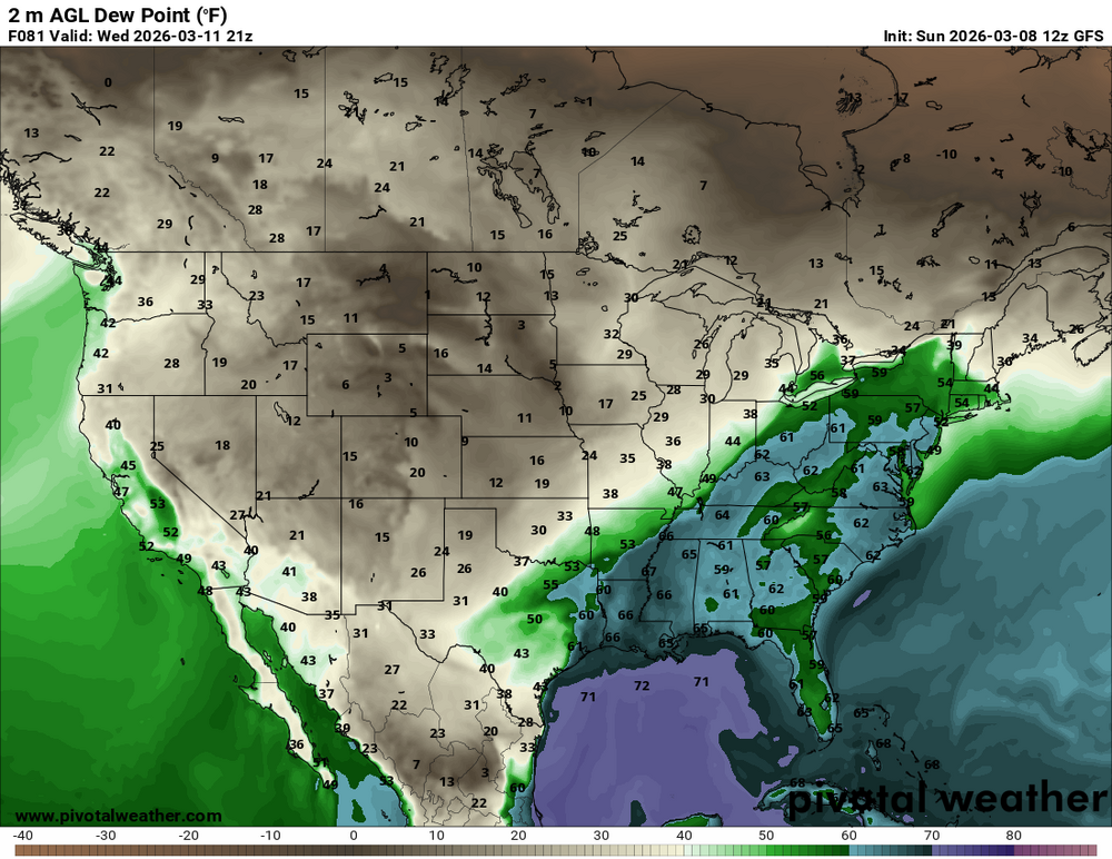
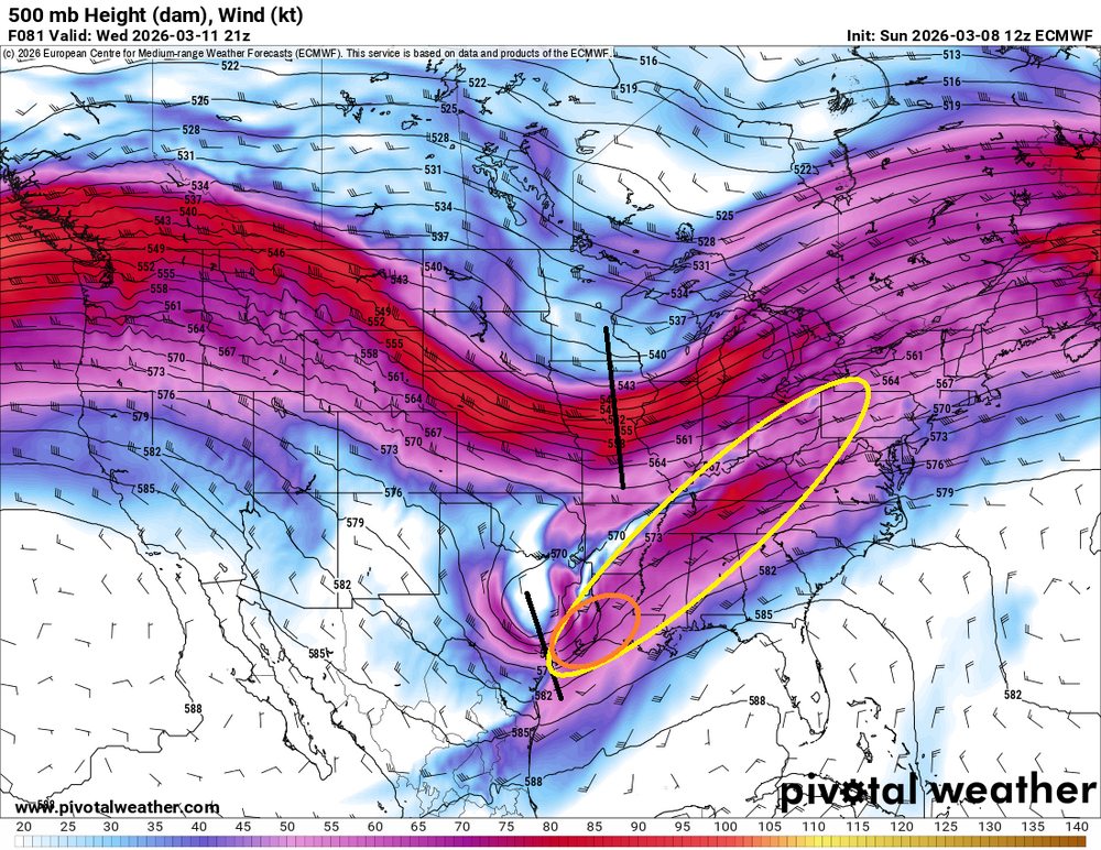
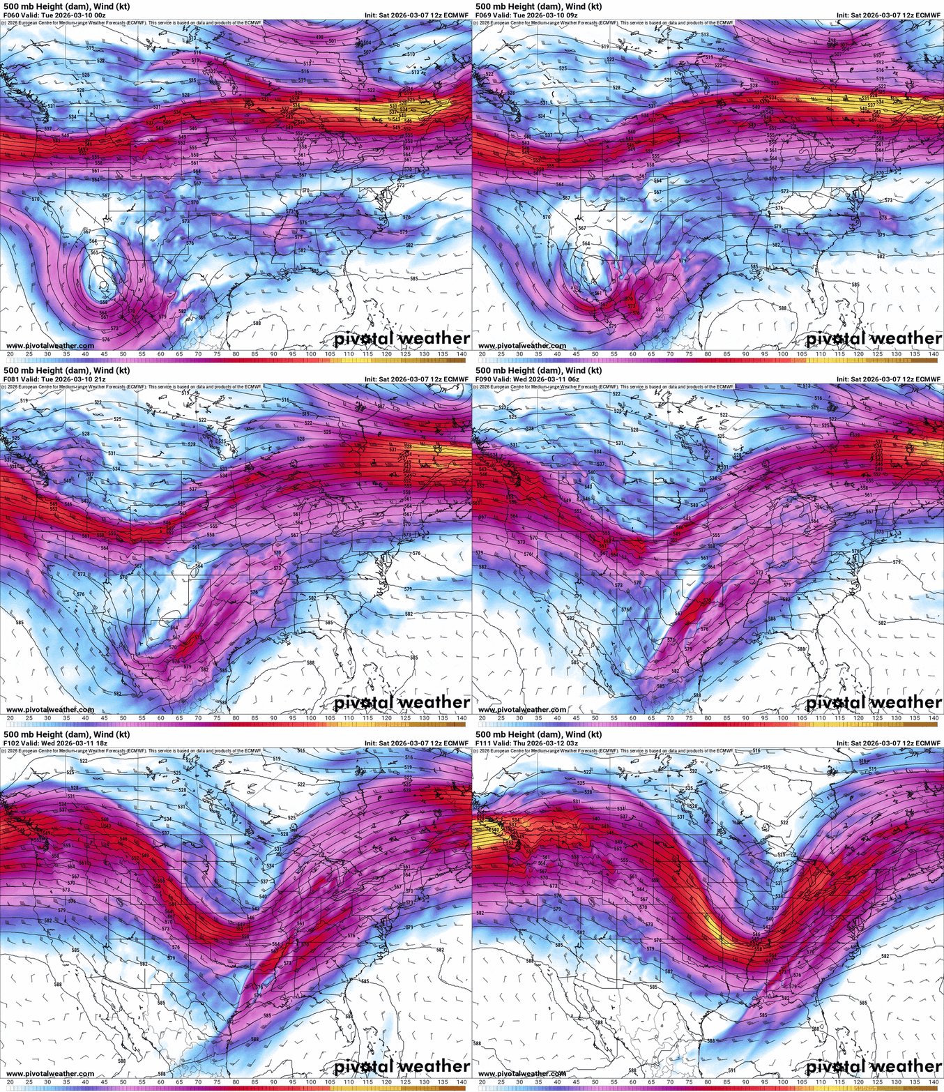
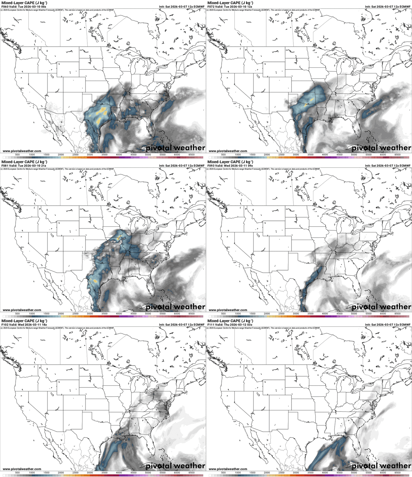
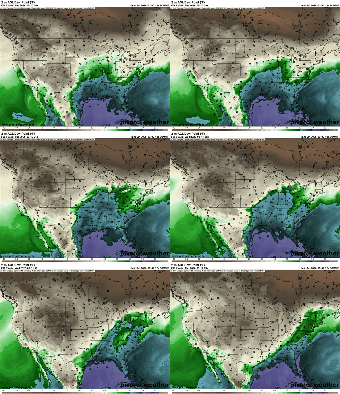
A complex and severe weather situation is expected to unfold in Kentucky and the Cincinnati area on Wednesday. Here’s the latest forecast based on current developments: On Wednesday, March 12, 2026 (from afternoon to evening), a powerful low-pressure system will strengthen as it moves northeast, pulling a cold front through the region. A large warm sector will exist, creating unstable conditions across Kentucky and southern Ohio, with the most significant instability located near the Lower Mississippi Valley and extending northward. Surface dewpoints are anticipated to reach the 60s F in Kentucky and southern Ohio, resulting in moderate instability, with MLCAPE values ranging from 500 to 1000 J/kg. While the instability will be most pronounced across the Lower Mississippi Valley, it will still contribute to active weather in the Ohio Valley, including Kentucky and Cincinnati. The main threat from severe weather will stem from damaging winds, particularly along developing lines of storms or convective clusters. A strong southwest jet stream at 500 mb (80-100 knots) will increase wind shear, raising the likelihood of damaging gusts. Should convection manage to stabilize and organize, the conditions could support the formation of a few tornadoes, especially in the northern and eastern regions of Kentucky. The primary concern will be widespread damaging winds from any intense storm lines, particularly during the late afternoon and evening hours. The most significant severe weather risks are expected from the afternoon into early evening as the cold front and associated storms progress through the area. Central and northern Kentucky, the Cincinnati metro area, and portions of southeastern Ohio are likely to be most impacted. Special caution should be taken in locations closer to the front, such as Lexington, Louisville, and areas just north of Cincinnati. Ongoing convection may affect the potential for greater instability in the northern regions, possibly slightly reducing the severity of storms. However, any breaks in the cloud cover combined with surface heating could dramatically heighten the storm threat, particularly with strong southerly winds in advance of the front. Remain vigilant for watches and warnings as the situation develops throughout the day!
-
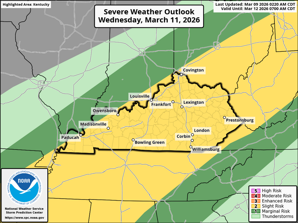
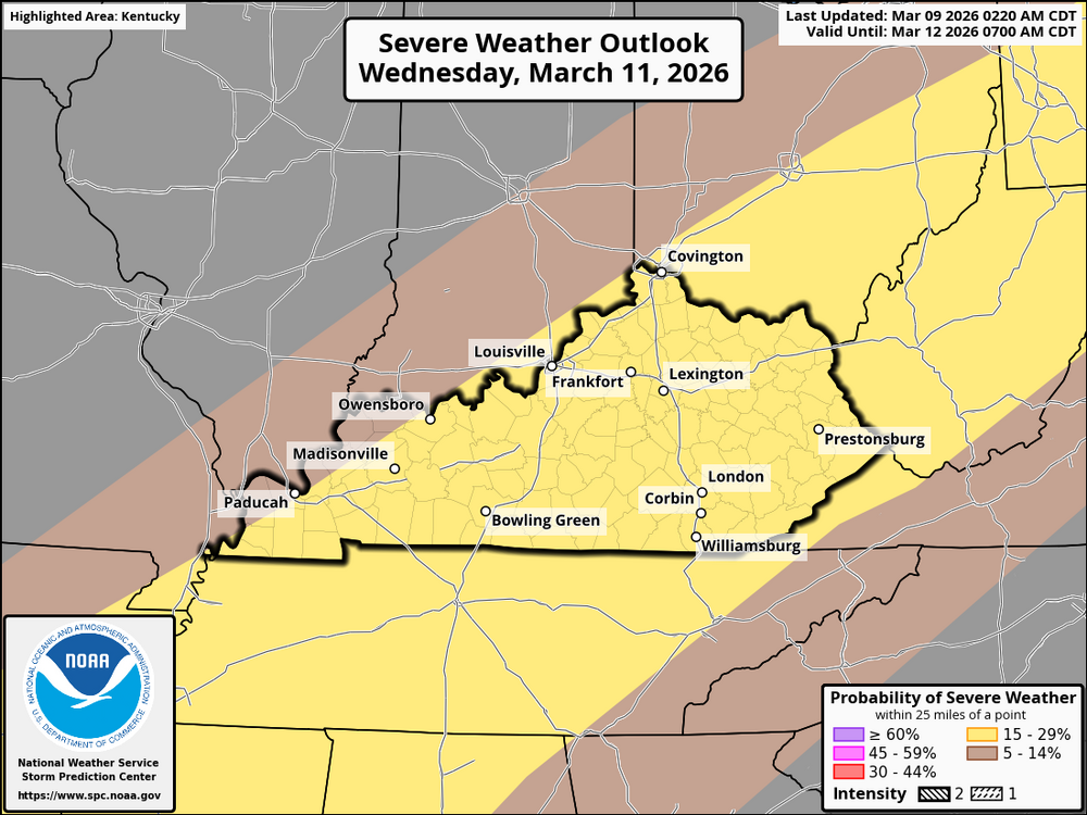
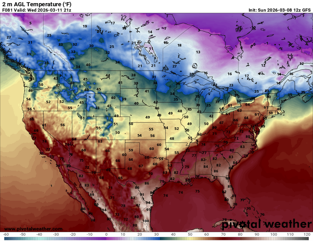
A cold front is expected to approach from the northwest later in the afternoon, increasing the likelihood of scattered thunderstorms. As the front approaches, expect higher temperatures and more cloud cover, with highs ranging from 55°F to 65°F, warmer in the state's south. Thunderstorms and showers are expected, along with heavy rainfall and strong winds. There is a high risk of damaging winds, with gusts reaching 40-50 mph in some areas. Some storms may become severe, with damaging winds being the main concern. If isolated cells form, there is a small risk of tornadoes, particularly in the western and central regions. As the evening approaches and the front moves forward, thunderstorms are expected to intensify, particularly in central and eastern Kentucky. By late evening, the eastern half of the state will face the greatest risk of severe weather, with damaging winds and localized flooding from heavy rain. As the front passes, temperatures will fall, reaching the upper 30s to low 40s by Thursday morning. Strong winds and damaging gusts can be dangerous, and heavy rain and localized flooding are also possible, especially during thunderstorms. A small tornado risk exists if isolated storm cells form near the surface low. It’s essential to stay informed about severe weather alerts, especially from late afternoon into the evening. The entire state of Kentucky and the Cincinnati area are in a level 2 slight risk area for possible strong to severe storms.
-
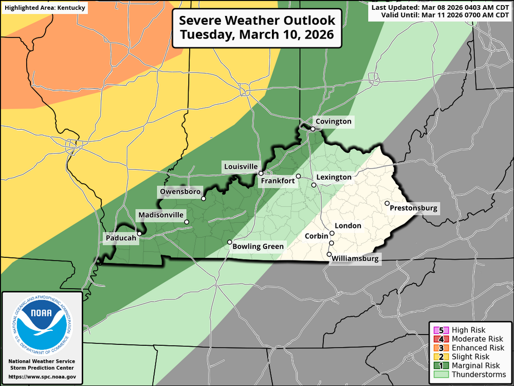
It appears that Wednesday could be the best chance to see widespread possible severe weather. Temperatures will rise to the mid-70s, with many places reaching around 74°F. Overnight lows will be in the mid-50s, around 54°F. This weather is unusually warm for March. Along with dewpoints in the low to mid 60s. The ingredients for severe weather could be in place. As the day goes on, strong thunderstorms are expected, and some of them could become severe, especially in the evening. There will also be strong wind gusts that may enhance the intensity of these storms. Areas such as Louisville, Lexington, Bowling Green, Cincinnati, and western Kentucky cities like Paducah, Owensboro, and Madisonville are included in the severe weather forecast, which warns of strong winds and thunderstorms. It's important to stay informed and check local updates for any weather watches or warnings throughout the day.
-
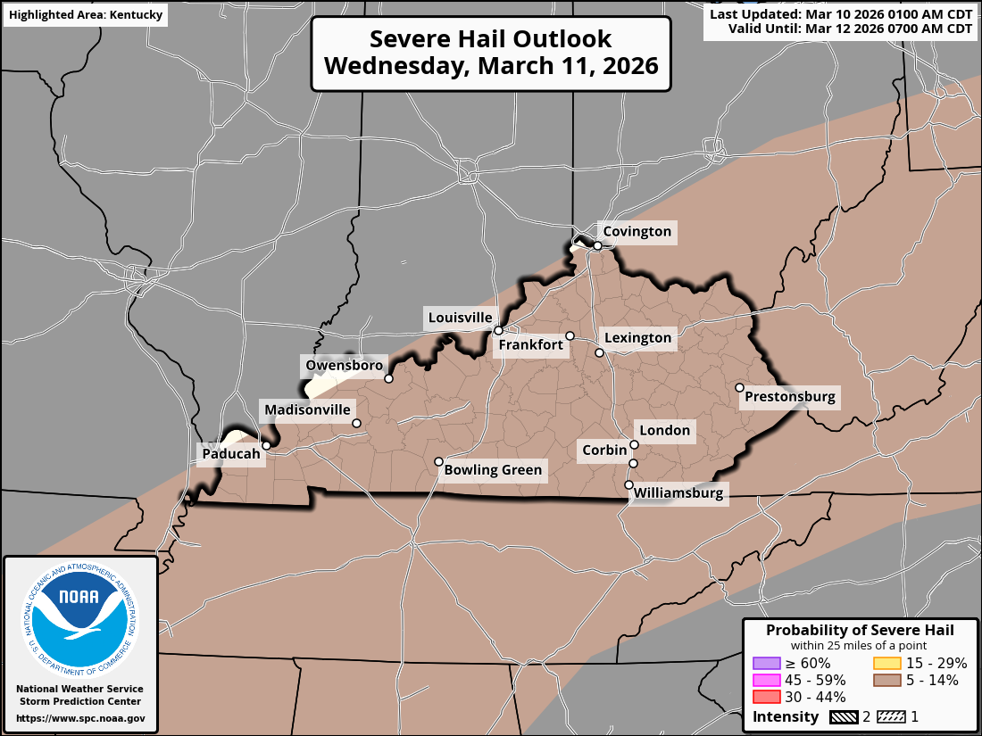
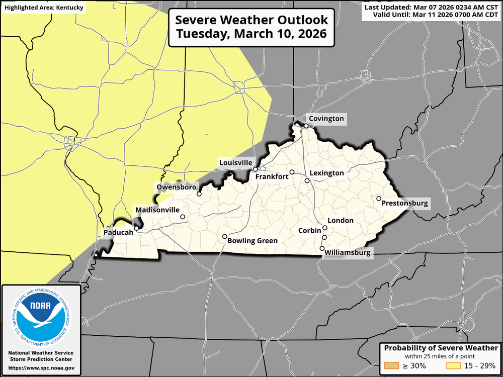
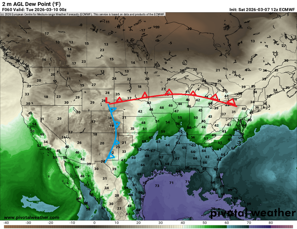
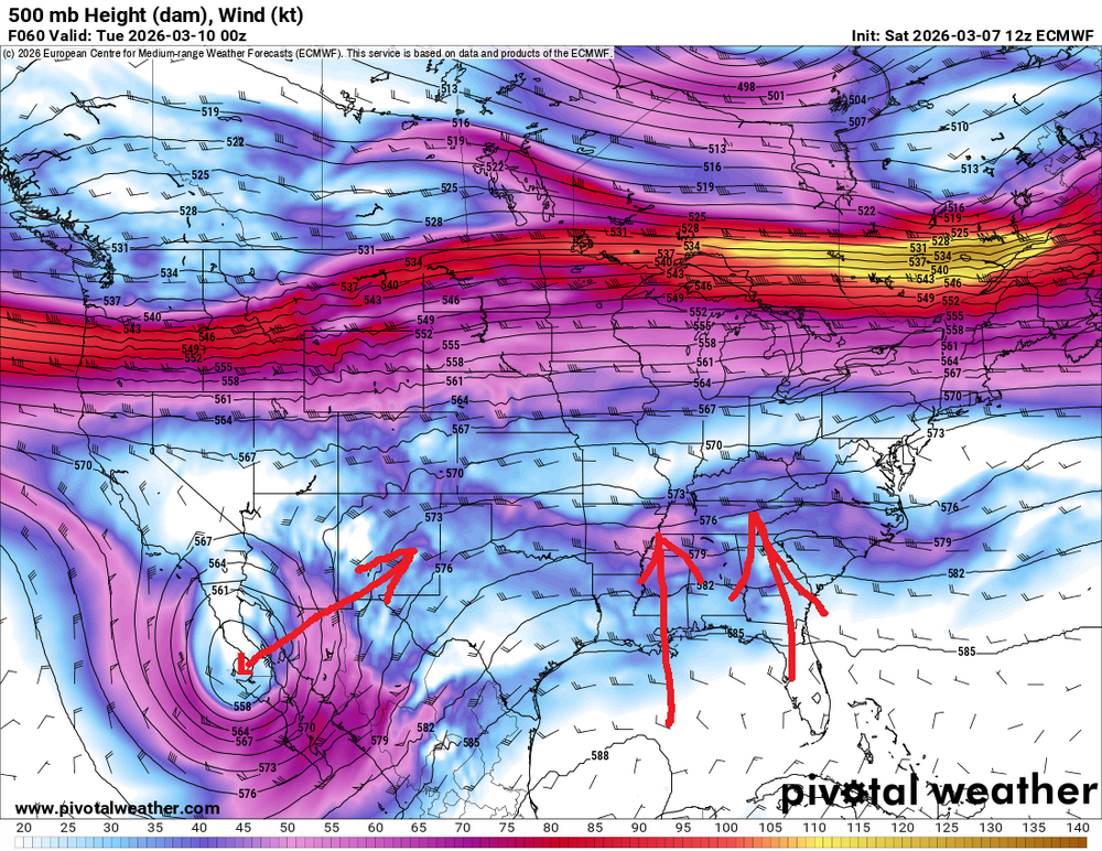
The weather forecast for Kentucky and the Cincinnati region on Tuesday, March 10, 2026, indicates the arrival of a complex storm system. A broad warm sector will stretch across Kentucky and the Ohio Valley, leading to strong southwesterly winds at mid to upper levels. Surface dewpoints are expected to rise into the 60s°F, which will contribute to atmospheric instability. Thunderstorms are likely to form in the afternoon and evening, with the possibility of severe weather. Conditions will be favorable for severe thunderstorms due to strong vertical wind shear and moderate instability. There is a risk of large to very large hail, especially from any discrete supercells that may develop. The highest risk for tornadoes will be near the surface warm front, potentially impacting central and eastern Kentucky, along with the Cincinnati area. This risk will peak during the late afternoon and evening hours. Additionally, damaging winds are a concern, particularly with linear storm segments after dark, where gusts could surpass 60 mph in some locations. Thunderstorms are predicted to begin forming between 2 PM and 4 PM, with the likelihood of severe weather increasing into the evening. The threat of severe storms may persist into the night, particularly for central and eastern Kentucky and the Cincinnati metro area. There remains some uncertainty regarding the exact positioning of the warm front and surface lows, so it’s crucial to stay informed about weather watches and warnings as the situation develops. Given the potential for tornadoes, ensure you have multiple methods to receive alerts, especially during the evening hours. Stay vigilant and take appropriate precautions, particularly in the late afternoon and evening, when the risk for severe weather is heightened.
-
This watch has been canceled
-
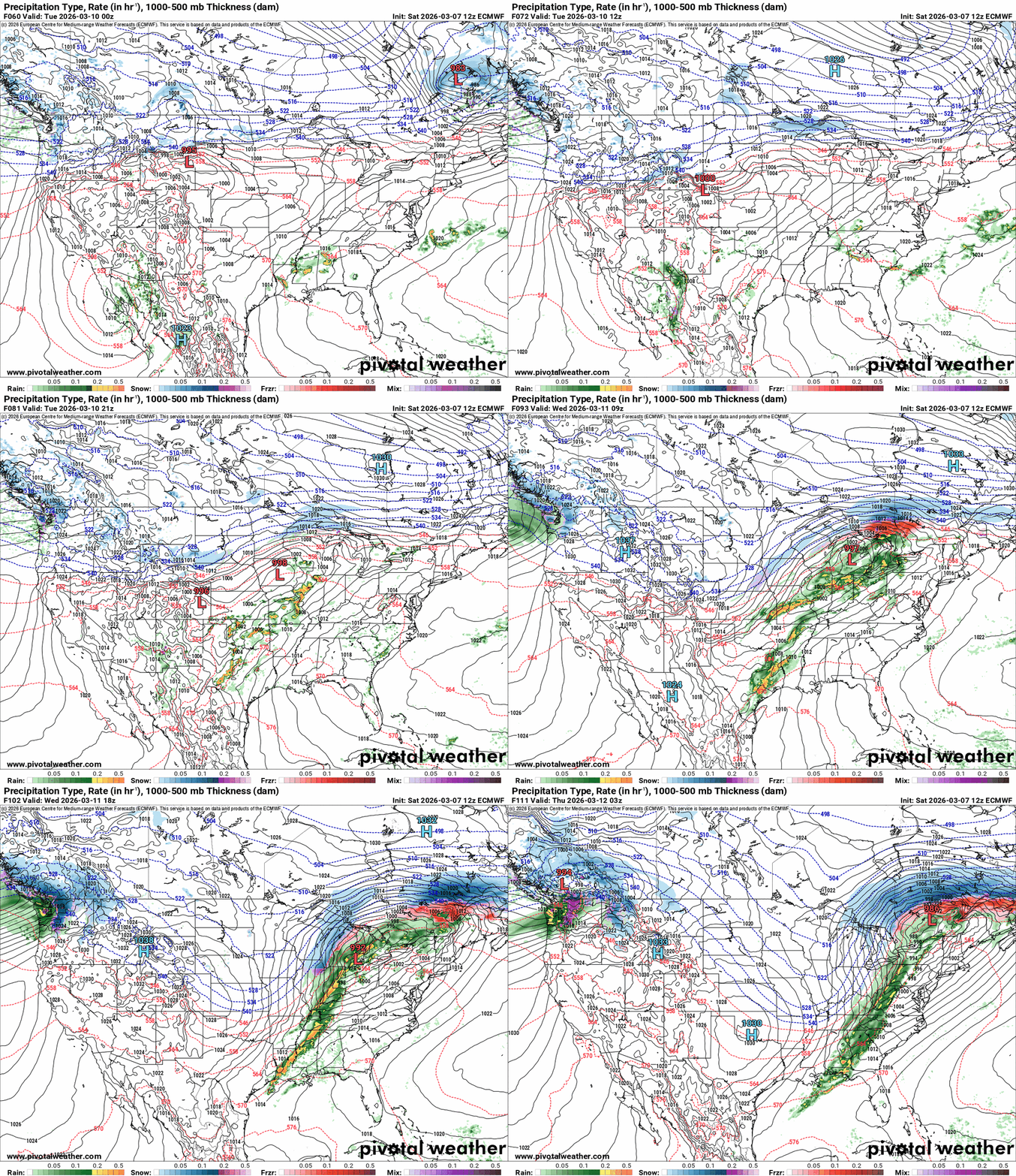
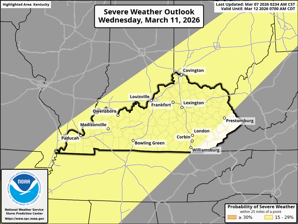
On Tuesday, March 10, 2026, an upper low shifting from northern Mexico will interact with a northern stream upper trough, promoting strong southerly flow and a developing surface low across the region. The primary focus for severe weather will be across the warm sector, as strong ascent ahead of a dryline and a cold front set the stage for thunderstorms. Expect severe thunderstorms to develop, with the potential for damaging winds, large hail, and possibly a tornado or two. The storms will be most intense in the late afternoon and evening, especially across central and southern Kentucky and the Cincinnati area. Strong winds aloft and shear will create favorable conditions for severe storms. Heavy rainfall is likely in addition to the severe threat. On Wednesday, March 11, 2026, the surface cold front will push eastward across Kentucky and Ohio. As the front moves through, instability may still be present, depending on how far east the storms develop on Tuesday and how much moisture gets drawn in. On Wednesday, there will be a lingering severe threat with isolated to scattered severe thunderstorms possible along the cold front as it moves across the region. The main hazards will again be damaging winds and hail, with a slight chance for tornadoes. The threat will shift eastward throughout the day, but storms will weaken as they progress eastward. They will still be potent for parts of Kentucky and the Cincinnati area, especially during the afternoon and evening hours. Key points to monitor include the timing, severe threats, and the potential for heavy rain and localized flooding with stronger storms. As always, monitor updates from the National Weather Service as the forecast evolves, especially with potential shifts in the timing and exact locations of the severe weather.
-
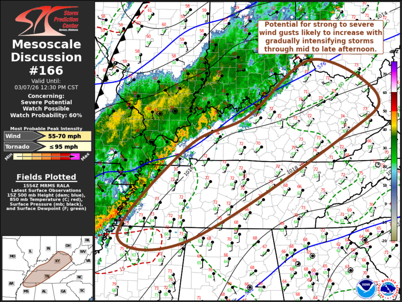
A Mesoscale Discussion (MD) is a technical bulletin issued by the Storm Prediction Center (SPC) in Norman, Oklahoma. Its primary purpose is to provide short-term guidance on organized, hazardous weather occurring or expected to develop within the next few hours. While a "General Forecast" covers days, and a "Warning" covers minutes, an MD fills the gap by focusing on the mesoscale—weather systems that are larger than a single thunderstorm but smaller than a cross-country cold front (typically 10 to several hundred miles wide). Key Features of an MD 1. The "Why" and the "When" An MD is essentially the SPC’s internal "thinking" made public. It explains the atmospheric ingredients—like instability, wind shear, and moisture—that are currently coming together. It usually addresses: Severe Thunderstorm or Tornado Potential: Often issued to indicate that a Watch is likely or to explain why one is not being issued. Winter Weather: Discussing heavy snow rates (e.g., 1–2 inches per hour) or significant freezing rain. Heavy Rainfall: Analyzing the potential for flash flooding. 2. The Map and "Polygon" Each MD includes a map with a highlighted area (a polygon). This isn't a warning, but rather a "heads up" for meteorologists and emergency managers in that specific region to stay weather-aware. 3. Probability of Watch Issuance One of the most critical parts of an MD is the Probability of Watch Issuance. The SPC will give a percentage (e.g., 5%, 40%, 80%) indicating how likely they are to issue a formal Tornado or Severe Thunderstorm Watch for the highlighted area.
-
The weather in Kentucky and the Cincinnati area for today, March 7, 2026, will be marked by a band of thunderstorms moving eastward. These storms are enhancing the cold front and will intensify through the afternoon as surface temperatures rise and convective inhibition weakens. As storms develop, strong winds aloft will support both supercells and organized clusters of storms, leading to the potential for severe weather. Expect increasing thunderstorm activity through midday and into the afternoon, particularly across northern Kentucky and southwestern Ohio. Strong winds are possible, with gusts reaching up to 60 mph in some areas. Additionally, there is a risk for tornadoes, especially in regions where storms are more organized, due to favorable conditions for rotating thunderstorms. By late afternoon and into the evening, these storms will begin to weaken as they move into the higher terrain of the Appalachians, where the atmosphere is less unstable. However, severe weather threats could still linger for some time in the Ohio River Valley before the storms lose their intensity. Residents of Kentucky and Cincinnati should stay alert to changing weather conditions, especially if they are in the path of any severe storms. There are currently no CIG levels issued. If a storm develops in your area, expect damaging winds of less than 74 mph. Possible hail less than 2 inches in diameter, as well as an EF0-EF1 tornado in intensity.
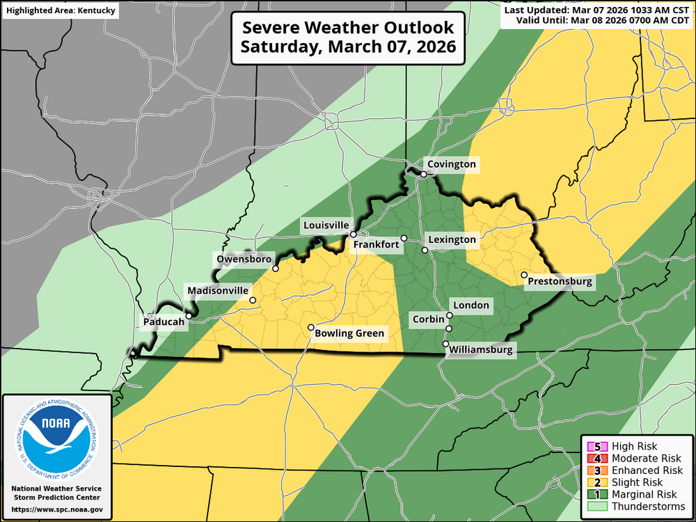
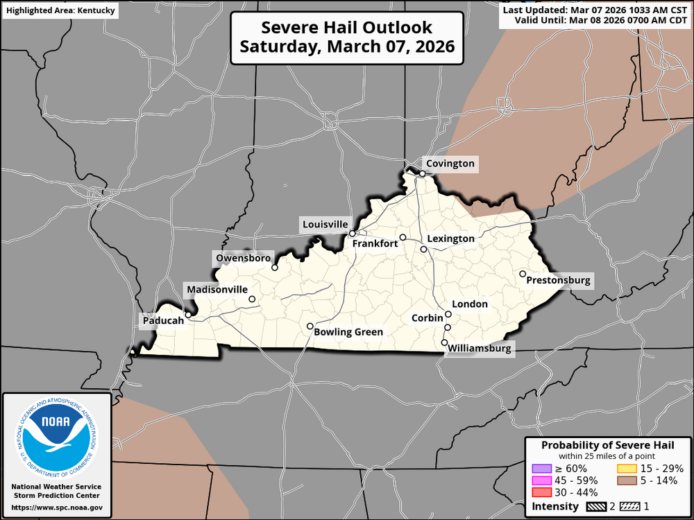
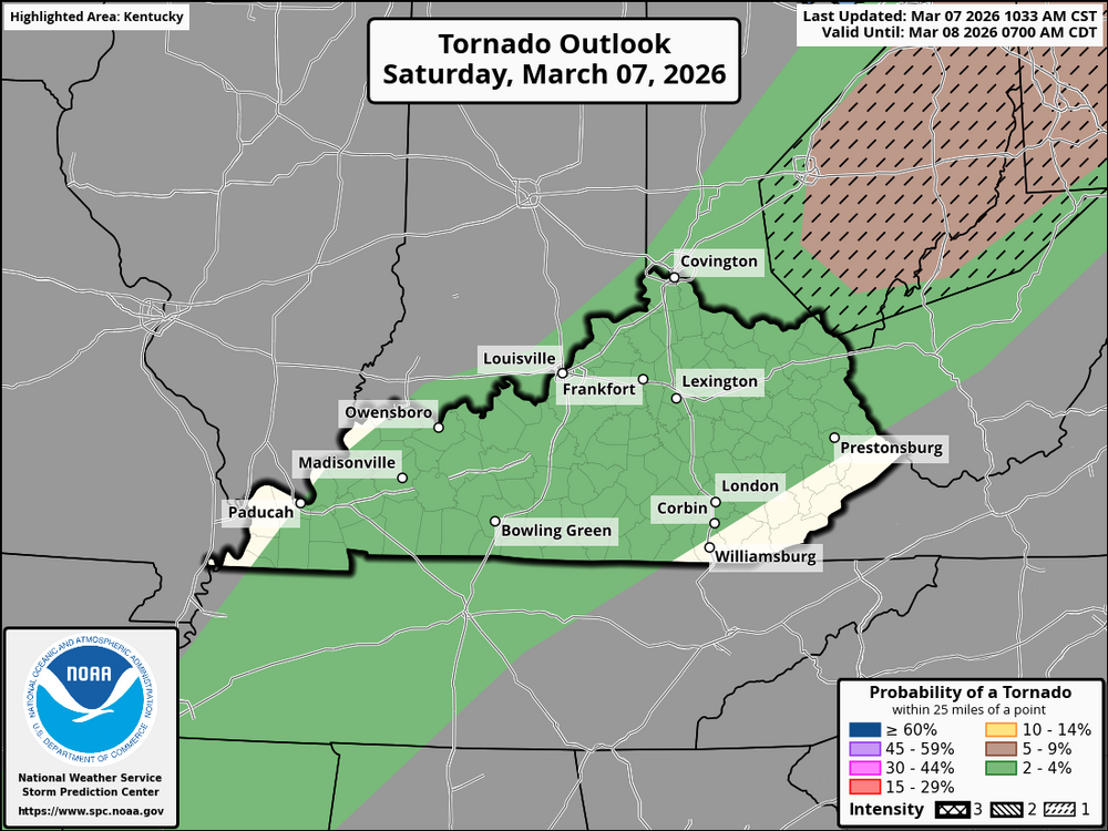
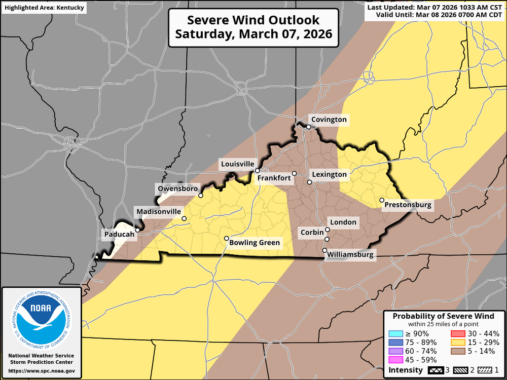
-
Mesoscale Discussion 0166 Issued by: NWS Storm Prediction Center Time: 09:57 AM CST, Sat Mar 07, 2026 Areas Affected: Southern Ohio, much of Kentucky, western and middle Tennessee, northern Mississippi, northwestern Alabama. Severe Potential: Severe weather watch possible. Summary: Thunderstorm activity is intensifying and may lead to strong to severe wind gusts as it spreads eastward through 1-3 PM CST (2-4 PM EST). A severe weather watch may be needed soon. Discussion: Stronger surface pressure rises (3-5 mb) are moving northeast from northeastern Arkansas into Missouri. This is linked to a low-amplitude jet streak forecast to affect Kentucky and Tennessee by late morning. Winds in the 850-700 mb layer are expected to be 30-50 knots. With ongoing heating and moisture advection, conditions are favorable for thunderstorms to strengthen and possibly produce severe wind gusts later in the day.
-
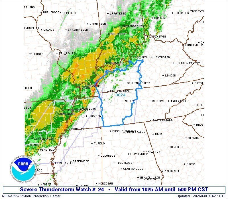
URGENT - IMMEDIATE BROADCAST REQUESTED Severe Thunderstorm Watch Number 24 NWS Storm Prediction Center Norman OK 1025 AM CST Sat Mar 7 2026 The NWS Storm Prediction Center has issued a * Severe Thunderstorm Watch for portions of Western and Central Kentucky Middle Tennessee * Effective this Saturday morning and afternoon from 1025 AM until 500 PM CST. * Primary threats include... Scattered damaging wind gusts to 70 mph possible A tornado or two possible SUMMARY...A line of storms will continue east-northeastward across the region this afternoon with damaging winds as the most common hazard. The severe thunderstorm watch area is approximately along and 60 statute miles east and west of a line from 50 miles north of Bowling Green KY to 85 miles south southwest of Nashville TN. For a complete depiction of the watch see the associated watch outline update (WOUS64 KWNS WOU4). PRECAUTIONARY/PREPAREDNESS ACTIONS... REMEMBER...A Severe Thunderstorm Watch means conditions are favorable for severe thunderstorms in and close to the watch area. Persons in these areas should be on the lookout for threatening weather conditions and listen for later statements and possible warnings. Severe thunderstorms can and occasionally do produce tornadoes.
-
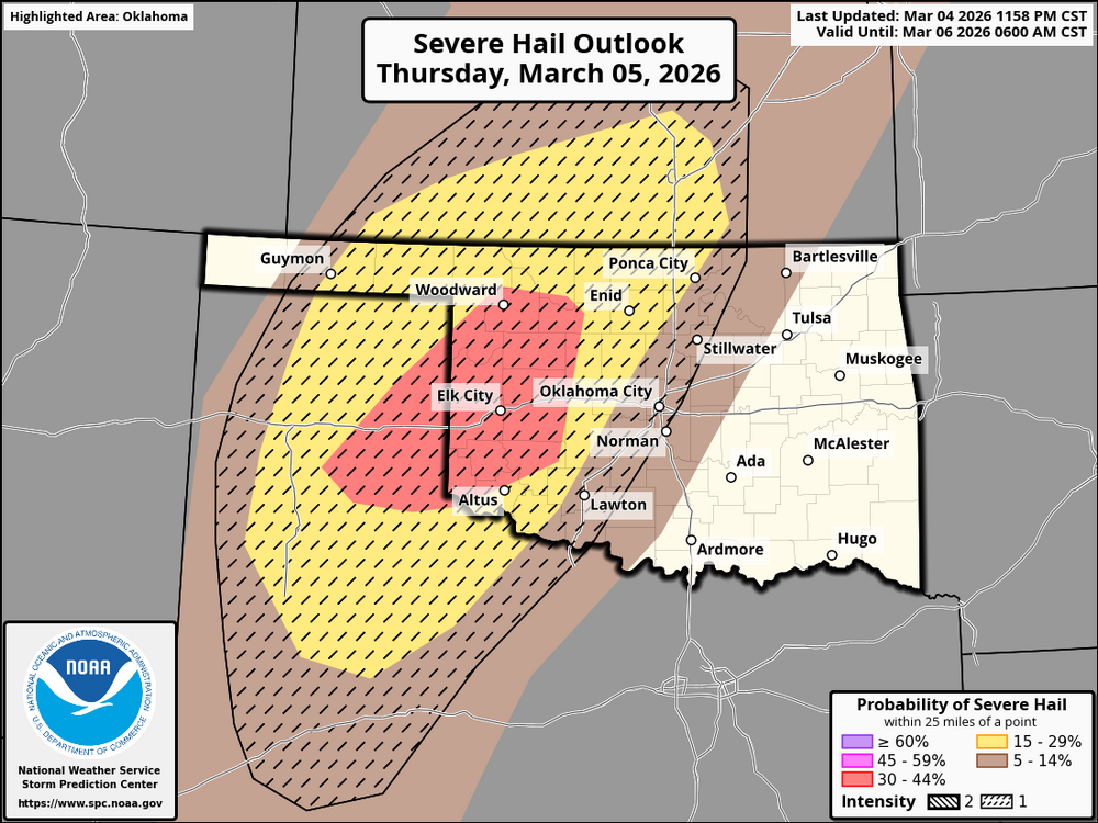
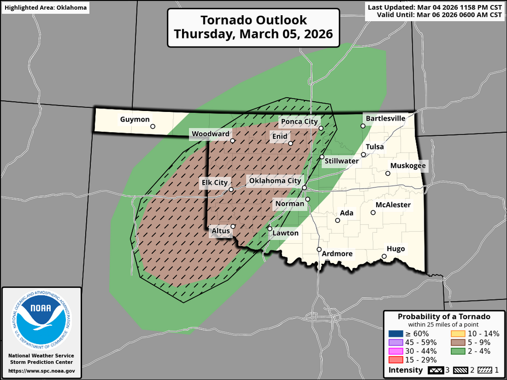
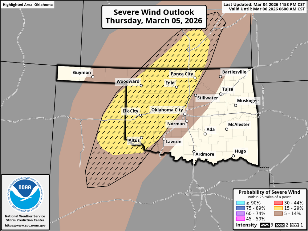
I thought I would illustrate how this new system will work. I'm using today's SPC outlook for the south-central US. The brown area has a 5–9% chance of seeing a tornado with a CIG 1 intensity level, according to the tornado outlook. This indicates that within 25 miles of a specific location, there is a slight chance of a tornado with the maximum predicted strength of EF2+. EF0-EF1 are primarily in the green hatched area. Here is the hail outlook. Applying this to this map, it shows a red hatched area with a CIG 1 intensity level along with a 30-44% chance of hail. This means an enhanced risk of hail >2 inches in diameter could occur. In the yellow, there is a slight risk of hail of the same diameter. In the brown, there is a marginal risk of >2-inch hail. Now for the severe wind outlook. Applying the same principle, The yellow is in a CIG 1 intensity level with a 15-29% chance of damaging winds. This translates to all storm modes, with peak wind gusts of 65+ kts. The brown has a 5-14% chance of the same. @theguru
-
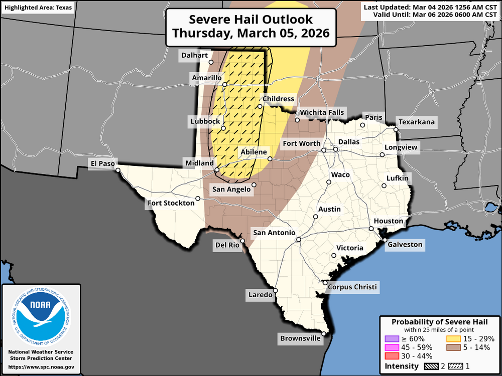
This is merely an illustration of the new SPC cig categories and how they will work. This is the severe hail forecast for portions of Oklahoma and Texas on Thursday. The yellow area may experience severe hail, but the hatched area indicates a supercell environment where the largest hail sizes, more than two inches, may occur. Hail with a diameter of less than two inches is likely to occur in the non-hatched area.
-
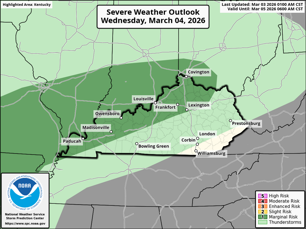
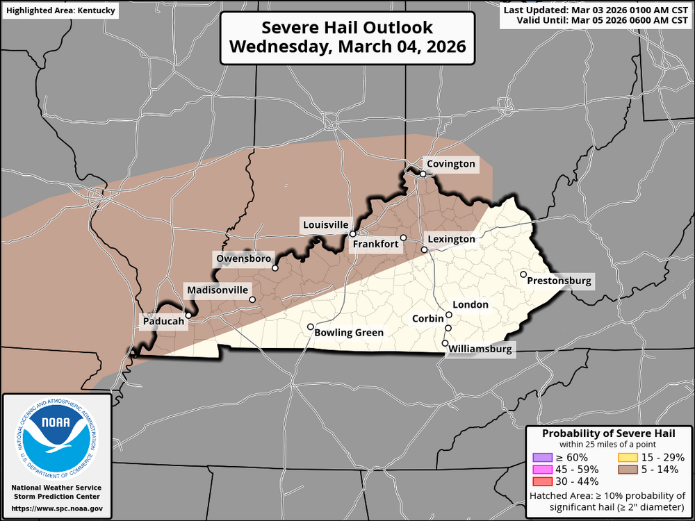
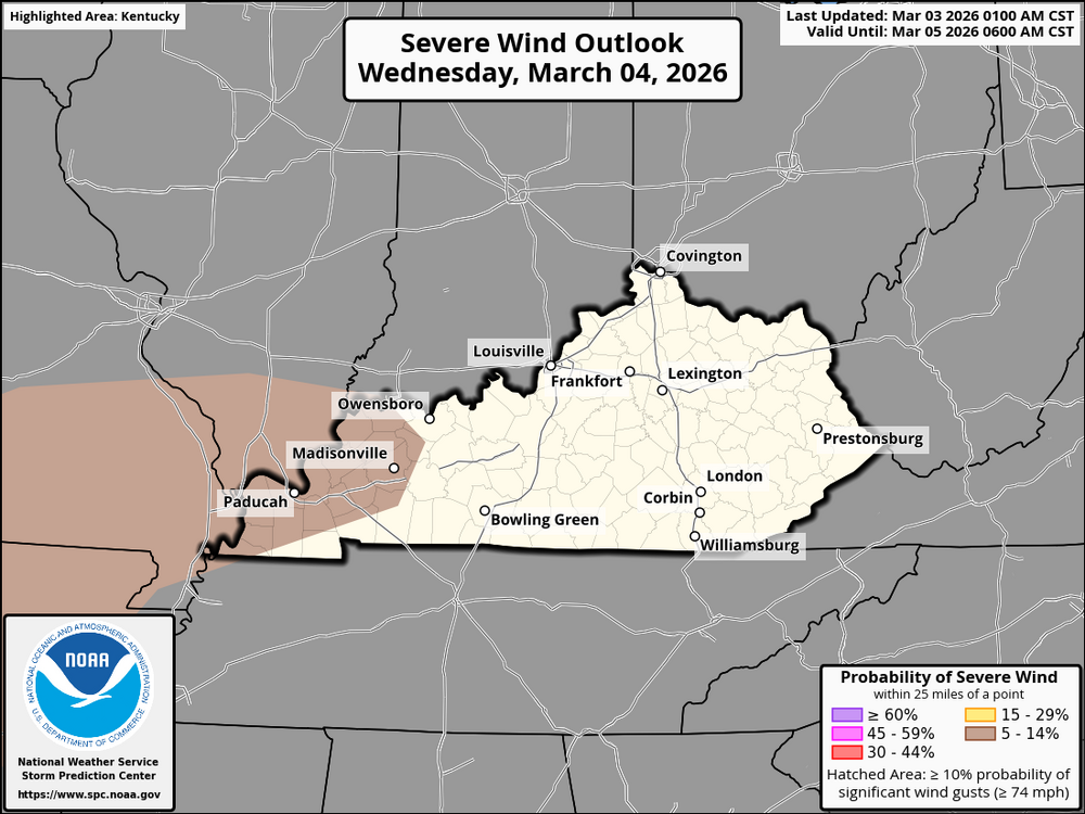
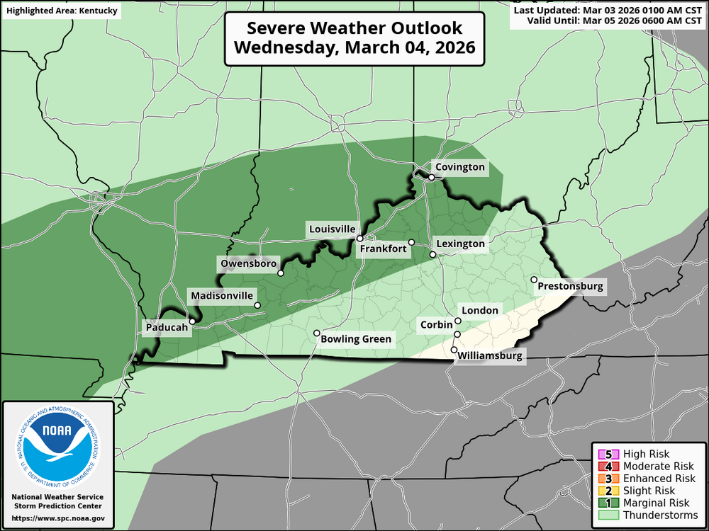
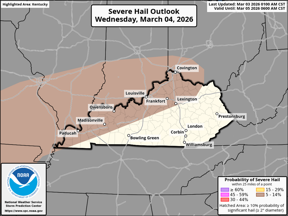
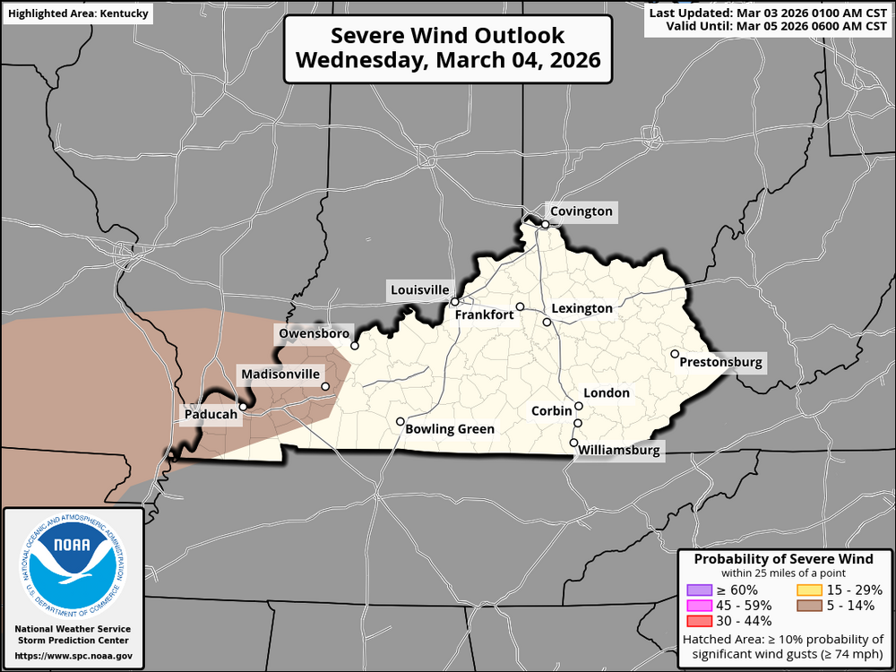
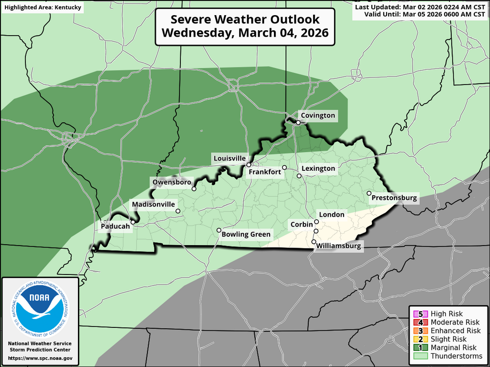
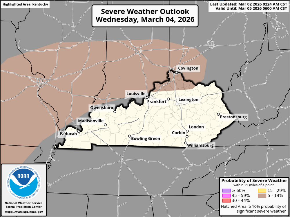
Kentucky & Cincinnati Area: Severe weather is predicted for Kentucky and the Cincinnati region on Wednesday, March 4, 2026. For Kentucky, primarily western Kentucky and the area north of I-64. In the afternoon and evening, scattered thunderstorms are predicted to form. The conditions will be right for thunderstorms, with moisture and instability in the air. These storms could bring large hail, especially in areas where the storms rotate. There is also a small chance of strong winds, particularly west of the region, in the mid-Mississippi Valley. If you live in the Cincinnati or Kentucky areas, stay alert and keep an eye on local weather updates. Be prepared for possible storms, hail, and wind. Stay safe!
-
In the afternoon and evening, scattered thunderstorms are predicted to form, especially in the Ohio Valley and some areas of Kentucky. Particularly in regions with moderate deep-layer shear, rotating storms carry a risk of isolated large hail. There may also be a slight risk of wind damage, primarily in the mid-Mississippi Valley to the west, where there may be a few surface-based storms. Storm development will be facilitated by moisture and instability, and the storm potential will be increased by steep lapse rates. Throughout the day, keep an eye on the weather and be ready for any changes!
-
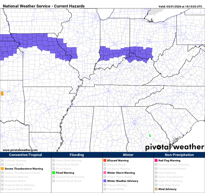
URGENT - WINTER WEATHER MESSAGE National Weather Service Wilmington OH 1152 AM EST Mon Mar 2 2026 INZ073>075-080-KYZ089>100-OHZ077>079-081-088-021800- /O.CON.KILN.WW.Y.0007.000000T0000Z-260302T1800Z/ Ripley-Dearborn-Ohio-Switzerland-Carroll-Gallatin-Boone-Kenton- Campbell-Owen-Grant-Pendleton-Bracken-Robertson-Mason-Lewis- Hamilton-Clermont-Brown-Adams-Scioto- Including the cities of Newport, Alexandria, Williamstown, Owenton, Dry Ridge, Milford, Peebles, Florence, Bright, Vanceburg, Falmouth, Rising Sun, Portsmouth, Fort Thomas, Mount Orab, Lawrenceburg, Greendale, Augusta, Batesville, Milan, Day Heights, Versailles, Ripley, Aurora, Erlanger, Mount Olivet, Highland Heights, Head Of Grassy, Burlington, Camp Dix, Dillsboro, Brooksville, Summerside, Mulberry, West Union, Georgetown, Downtown Cincinnati, Hidden Valley, Mount Carmel, Carrollton, Butler, Crittenden, Maysville, Osgood, Oakbrook, Warsaw, Wheelersburg, Covington, Winchester, Seaman, Mount Repose, Dayton, Tollesboro, Aberdeen, Manchester, Vevay, Bellevue, Independence, and Withamsville 1152 AM EST Mon Mar 2 2026 ...WINTER WEATHER ADVISORY REMAINS IN EFFECT UNTIL 1 PM EST THIS AFTERNOON... * WHAT...Mixed precipitation. Little additional snow accumulations and ice accumulations around a light glaze. * WHERE...Portions of southeast Indiana, northeast and northern Kentucky, and south central and southwest Ohio. * WHEN...Until 1 PM EST this afternoon. * IMPACTS...Roads, and especially bridges and overpasses, will likely become slick and hazardous. Plan on slippery road conditions. PRECAUTIONARY/PREPAREDNESS ACTIONS... Slow down and use caution while traveling. In Indiana, visit 511in.org or call 1-800-261-7623 for the latest road information. In Kentucky, visit goky.ky.gov for the latest road information. In Ohio, visit ohgo.com for the latest road information. Be prepared for slippery roads. Slow down and use caution while driving. If you are going outside, watch your first few steps taken on stairs, sidewalks, and driveways. These surfaces could be icy and slippery, increasing your risk of a fall and injury.
-
URGENT - WINTER WEATHER MESSAGE National Weather Service Wilmington OH 1152 AM EST Mon Mar 2 2026 OHZ073-074-080-082-021800- /O.CON.KILN.WW.Y.0007.000000T0000Z-260302T1800Z/ Ross-Hocking-Highland-Pike- Including the cities of Greenfield, Pike Lake, Logan, Piketon, Chillicothe, Waverly, and Hillsboro 1152 AM EST Mon Mar 2 2026 ...WINTER WEATHER ADVISORY REMAINS IN EFFECT UNTIL 1 PM EST THIS AFTERNOON... * WHAT...Mixed precipitation. Little additional snow accumulations and ice accumulations around a light glaze. * WHERE...Hocking, Highland, Pike, and Ross Counties. * WHEN...Until 1 PM EST this afternoon. * IMPACTS...Roads, and especially bridges and overpasses, will likely become slick and hazardous. Plan on slippery road conditions. PRECAUTIONARY/PREPAREDNESS ACTIONS... Slow down and use caution while traveling. visit ohgo.com for the latest road information.
-
On Wednesday, a low-pressure system will move east from northern Missouri into north-central Illinois, bringing a west-southwesterly mid-level flow across Kentucky and the Cincinnati area. A warm front will move north, making the Ohio Valley warmer and more humid. This setup will help weak instability grow, especially south of the warm front. Dewpoints on the surface will be in the 50s°F, which will help weak instability. As the low-level jet picks up speed to 30–40 knots, thunderstorms will probably happen in the afternoon and evening, especially in the Ohio Valley. Thunderstorms will be few and far between, with the best chances in the western and central parts of Kentucky and the Cincinnati area. Effective shear of about 40 knots and lapse rates of about 7.5°C/km will create conditions that are good for a marginal severe threat, with a focus on hail and strong wind gusts that happen only once in a while. There could be small to medium-sized hail and strong winds (50–60 mph) that only happen in certain areas with the strongest storms. Around noon, thunderstorms will probably start to form and get stronger throughout the afternoon, peaking in the late afternoon to early evening hours. There is a higher chance of thunderstorms in central and western Kentucky. The Cincinnati area is at a level 1 marginal risk of severe weather, which could include hail and strong winds. Watch for updates because things can change quickly with this kind of setup.
 Special Weather Statement National Weather Service Jackson KY 149 PM EST Sun Mar 1 2026 KYZ044-050>052-058>060-104-106>109-020700- Fleming-Montgomery-Bath-Rowan-Estill-Powell-Menifee-Elliott- Morgan-Johnson-Wolfe-Magoffin- Including the cities of Flemingsburg, Camargo, Jeffersonville, Mount Sterling, Owingsville, Morehead, Irvine, Ravenna, Clay City, Stanton, Frenchburg, Sandy Hook, West Liberty, Paintsville, Campton, and Salyersville 149 PM EST Sun Mar 1 2026 ...Wintry Mix is Expected Late Tonight through Mid-Monday Morning... A system moving into the area overnight will bring a mixed bag of precipitation through mid-morning on Monday. Precipitation will start as snow but quickly transition to a wintry mix by the morning commute. A light coating of snow, mainly along the I-64 corridor, and icy spots will be possible especially on bridges and overpasses. While surface temperatures will hover around freezing, some slick travel will be possible during the Monday morning commute. Motorists are encouraged to slow down and allow extra time to reach your destination Monday morning.Special Weather Statement National Weather Service Louisville KY 259 PM EST Sun Mar 1 2026 INZ076>079-083-084-089>092-KYZ023>025-028>043-045>049-056-057- 021000- Orange-Washington IN-Scott IN-Jefferson IN-Dubois-Crawford-Perry- Harrison IN-Floyd-Clark IN-Hancock-Breckinridge-Meade-Hardin- Bullitt-Jefferson-Oldham-Trimble-Henry-Shelby-Franklin-Scott KY- Harrison KY-Spencer-Anderson-Woodford-Fayette-Bourbon-Nicholas- Nelson-Washington KY-Mercer-Jessamine-Clark KY-Garrard-Madison- Including the cities of Paoli, Salem, Scottsburg, Madison, Jasper, English, Tell City, Corydon, New Albany, Jeffersonville, Lewisport, Hawesville, Hardinsburg, Brandenburg, Elizabethtown, Shepherdsville, Louisville, La Grange, Bedford, Milton, New Castle, Shelbyville, Frankfort, Georgetown, Cynthiana, Taylorsville, Lawrenceburg, Versailles, Lexington, Paris, Carlisle, Bardstown, Springfield, Harrodsburg, Nicholasville, Winchester, Lancaster, and Richmond 259 PM EST Sun Mar 1 2026 /159 PM CST Sun Mar 1 2026/ ...A Wintry Mix of Precipitation is Expected Late Tonight and Monday Morning... Late tonight, a weather disturbance will move into the region from the west. Precipitation will likely start off as snow across much of southern Indiana, but a wintry mix of snow, sleet, and freezing rain will be possible, mainly in areas north of a line from Hawesville to Elizabethtown to Richmond. A slushy accumulation of up to one inch will be possible in areas along and north of the I-64 corridor. Just to the south of the I-64 corridor a light coating of snow with a light glaze of ice will be possible. While surface temperatures will be right at freezing, some slick travel will be possible during the Monday morning commute, especially on bridges and overpasses. Stay up to date with the latest forecasts and allow extra time to reach your destination Monday morning. Stay tuned to NOAA Weather Radio and your local media for the latest forecast updates.URGENT - WINTER WEATHER MESSAGE National Weather Service Wilmington OH 1233 PM EST Sun Mar 1 2026 KYZ089-090-094>100-020145- /O.NEW.KILN.WW.Y.0007.260302T0800Z-260302T1600Z/ Carroll-Gallatin-Owen-Grant-Pendleton-Bracken-Robertson-Mason- Lewis- Including the cities of Maysville, Carrollton, Augusta, Tollesboro, Camp Dix, Head Of Grassy, Dry Ridge, Williamstown, Butler, Owenton, Warsaw, Mount Olivet, Crittenden, Brooksville, Vanceburg, and Falmouth 1233 PM EST Sun Mar 1 2026 ...WINTER WEATHER ADVISORY IN EFFECT FROM 3 AM TO 11 AM EST MONDAY... * WHAT...Mixed precipitation expected. Total snow accumulations up to one inch, with ice accumulations of several hundredths possible. * WHERE...Lewis, Bracken, Carroll, Gallatin, Grant, Mason, Owen, Pendleton, and Robertson Counties. * WHEN...From 3 AM to 11 AM EST Monday. * IMPACTS...Roads, and especially bridges and overpasses, will likely become slick and hazardous. Plan on slippery road conditions. The hazardous conditions could impact the Monday morning commute. PRECAUTIONARY/PREPAREDNESS ACTIONS... Slow down and use caution while traveling. visit goky.ky.gov for the latest road information. Be prepared for slippery roads. Slow down and use caution while driving. If you are going outside, watch your first few steps taken on stairs, sidewalks, and driveways. These surfaces could be icy and slippery, increasing your risk of a fall and injury.URGENT - WINTER WEATHER MESSAGE National Weather Service Wilmington OH 1233 PM EST Sun Mar 1 2026 INZ066-073>075-080-KYZ091>093-OHZ070>073-077>082-088-020145- /O.NEW.KILN.WW.Y.0007.260302T0800Z-260302T1600Z/ Franklin-Ripley-Dearborn-Ohio-Switzerland-Boone-Kenton-Campbell- Butler-Warren-Clinton-Ross-Hamilton-Clermont-Brown-Highland-Adams- Pike-Scioto- Including the cities of Florence, Oakbrook, Mount Orab, Bellevue, Peebles, Summerside, Brookville, Highland Heights, Greendale, Downtown Cincinnati, Milford, Alexandria, Fairfield, Franklin, West Union, Independence, Burlington, Lawrenceburg, Mount Repose, Landen, Greenfield, Fort Thomas, Versailles, Hidden Valley, Batesville, Wilmington, Erlanger, Waverly, Osgood, Newport, Wheelersburg, Day Heights, Aurora, Bright, Withamsville, Pike Lake, Seaman, Vevay, Hamilton, Dayton, Oxford, Middletown, Springboro, Mason, Portsmouth, Milan, Aberdeen, Blanchester, Rising Sun, Manchester, Piketon, Mount Carmel, Lebanon, Dillsboro, Chillicothe, Ripley, Winchester, Covington, Hillsboro, Georgetown, and Mulberry 1233 PM EST Sun Mar 1 2026 ...WINTER WEATHER ADVISORY IN EFFECT FROM 3 AM TO 11 AM EST MONDAY... * WHAT...Mixed precipitation expected. Total snow accumulations of 1 to 2 inches, with isolated higher amounts. Total ice accumulations of a light glaze are possible. * WHERE...Portions of southeast Indiana, northern Kentucky, and south central and southwest Ohio. * WHEN...From 3 AM to 11 AM EST Monday. * IMPACTS...Roads, and especially bridges and overpasses, will likely become slick and hazardous. Plan on slippery road conditions. The hazardous conditions could impact the Monday morning commute. PRECAUTIONARY/PREPAREDNESS ACTIONS... Slow down and use caution while traveling. In Indiana, visit 511in.org or call 1-800-261-7623 for the latest road information. In Kentucky, visit goky.ky.gov for the latest road information. In Ohio, visit ohgo.com for the latest road information.