.png.ffa34568722b20f38e3c3ecfcb9a2cd2.png)

.jpg.f607a105a9049bd28b594967f8dbef8e.jpg)
nWo
-
Posts
25,535 -
Joined
-
Last visited
-
Days Won
1
Everything posted by nWo
-
Just got a message from rockmom the storm has just reached where she lives.
-

-
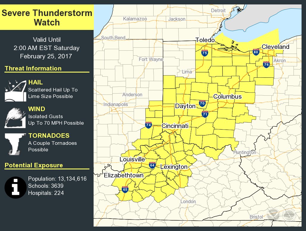
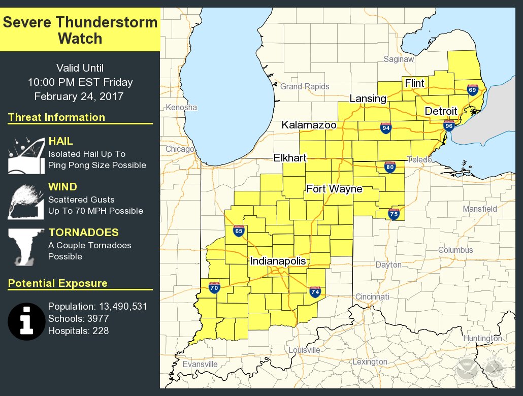
Just issued a Severe Thunderstorm Watch for parts of Kentucky.
-
Sever Thunderstorm Watch maybe issued soon.
-
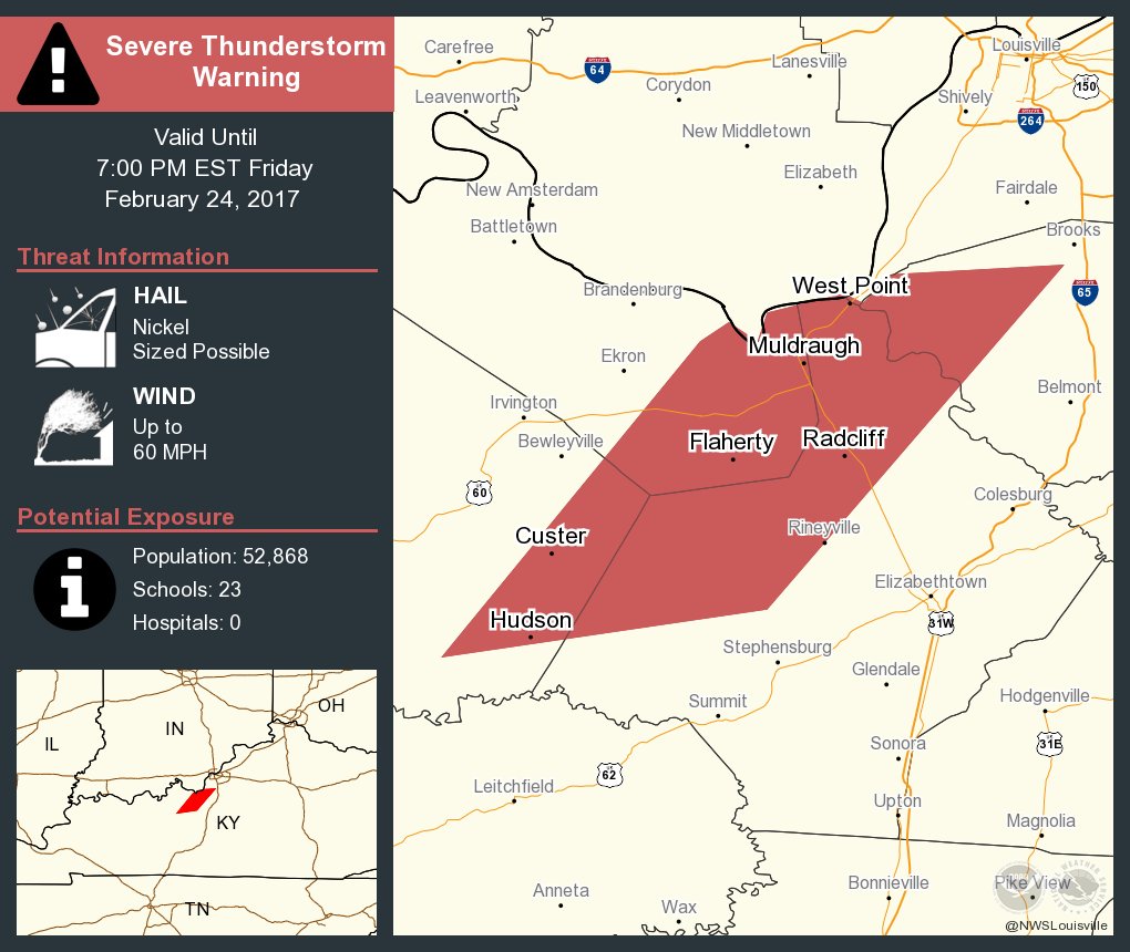
Radcliff area
-
I thought it was.
-
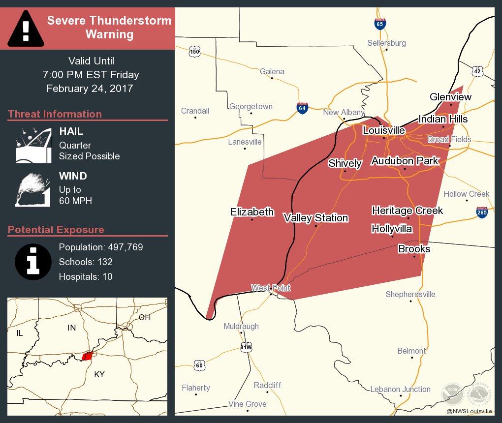
One just issued for the Louisville area
-
BULLETIN - IMMEDIATE BROADCAST REQUESTED Severe Thunderstorm Warning National Weather Service Louisville KY 616 PM EST FRI FEB 24 2017 The National Weather Service in Louisville has issued a * Severe Thunderstorm Warning for... Western Jefferson County in south central Indiana... Northern Clark County in south central Indiana... Southern Scott County in south central Indiana... Northern Trimble County in central Kentucky... * Until 645 PM EST * At 615 PM EST, a severe thunderstorm was located 9 miles south of Scottsburg, moving northeast at 55 mph. HAZARD...60 mph wind gusts and quarter size hail. SOURCE...Radar indicated. IMPACT...Hail damage to vehicles is expected. Expect wind damage to roofs, siding, and trees. * Locations impacted include... Madison, Scottsburg, Bedford, Vienna, Lexington, Hanover, Saluda, Smyrna, Milton and Kent. PRECAUTIONARY/PREPAREDNESS ACTIONS... For your protection move to an interior room on the lowest floor of a building.
-
I'll be leaving work in about 10 minutes so there will be a little time until my next update.
-
:thumb:
-
Tell her to be careful.
-
New Severe Thunderstorm Watch just issued for parts of Indiana. Things are starting to pop.
-
You're welcome. It is my pleasure.
-
Storms are starting to fire up in Indiana.
-
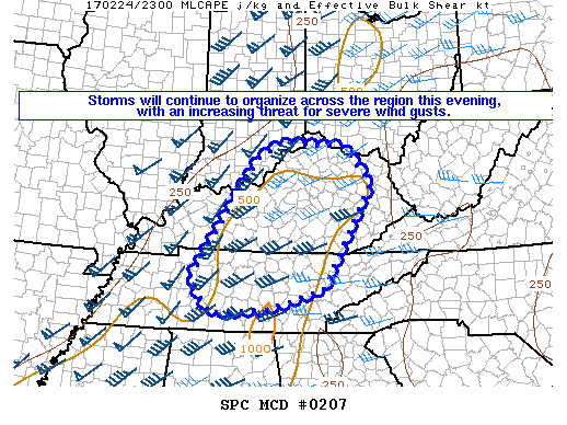
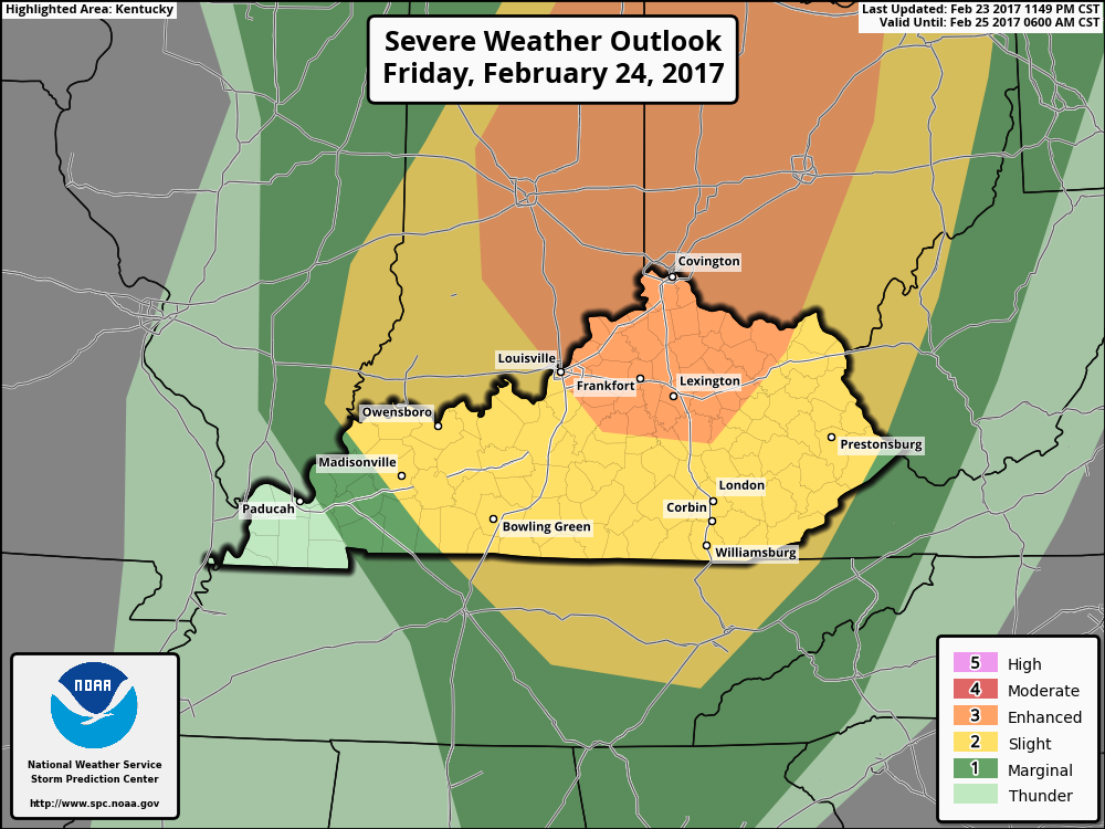
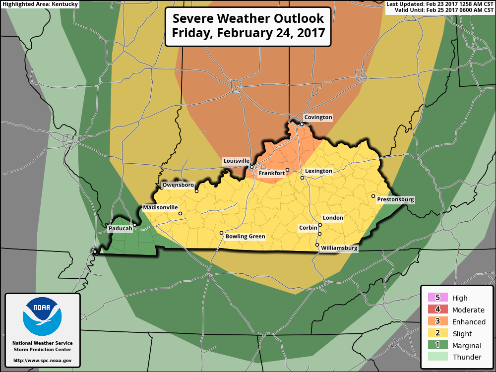
Friday Morning update: The Storm Prediction Center has expanded the Enhanced Risk area south and eastward. The southern edge of the is from Louisville over the Richmond over to Morehead then up to around Vanceburg. Those living in this area could see severe storms capable of producing damaging winds, hail and a few tornadoes. The rest of Kentucky, except for WKY, is in a Slight Risk area for strong to severe storms. The timing of the storms as of this morning looks like this. Remember these are estimates. Around the 1 pm EST hour storm activity should be starting in Illinois. They should be moving into southwestern Indiana around 4 pm EST. Louisville could see the storms around 7 pm EST. Northern and central Kentucky should see the storms around the 10 pm EST time period. Storm activity should be going on it eastern Kentucky by early Saturday morning but they should have lost some of their intensity by then. I will update throughout the day when the information warrants it. Also there will be updates on our twitter feed. I expect to be busy tonight and this evening. This is the first time I've been emailed severe weather information from NOAA WRN to warn our members. Stay weather aware today.
-
I'll spent part of my work day tomorrow checking our tornado shelters at work. Hopefully they won't have to be used.
-
No real changes tonight for tomorrow's possible severe weather. I will post the timing of the storms early in the morning.
-
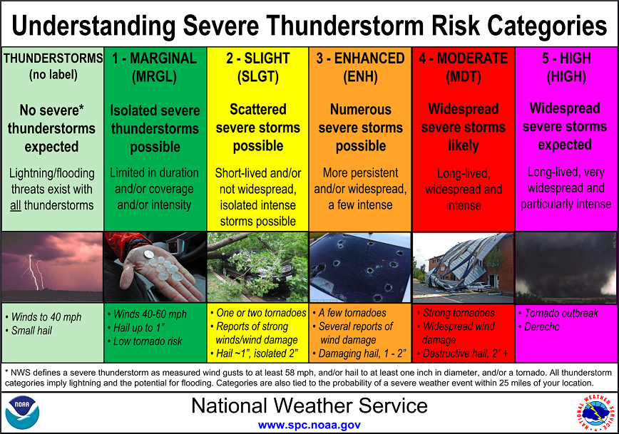
I'm going into a Severe Weather Alert mode for Friday afternoon into the evening hours. As I posted yesterday the risk for strong to severe storms has increased. Part of Kentucky, Indiana and western Ohio are now in an category 3 Enhanced Risk area for strong to severe storms. Those in an area from Louisville to Frankfort over to around Georgetown up to Maysville should pay particular head to the weather. The rest of Kentucky is in a category 2 Slight Risk Area except for WKY and extreme EKY. They are in a Marginal Risk area. For now the best time to see these storms look to be from around the 4 pm to midnight ET time slot. Everyone should be weather aware for Friday. I'll post an update later today. Also there will be updates on our twitter feed. http://bluegrasspreps.com/bgp-break-room/bgp-com-weather-342822.html This chart explains the different categories of storms.
-
I'm going to issue a severe weather alert day for Friday. All new information will be posted in a new thread.
-
I hear you! Just trying to help people with information but you know how it is. :thumb:
-
I was wanting to dislike your post but I was laughing too hard!! :lol2:
-
I don't know maybe the member didn't like clouds? :thumb:
-
I thought I was a very likeable guy but now I :idunno:!
-
Well I believe I just got my first dislike!! :sour::ohbrother::thumb:
-
Wednesday evening update: The only real change for this evening is that the supercell and tornado chances look to have increased for Friday night for parts of SW Indiana, northern and central Kentucky. This area is centered around a line from NKY back southwestward along the Ohio River to about the I-65 corridor southward to Bowling Green. The timing is still up in the air. If this trend continues I will probably go into a severe weather threat mode sometime tomorrow. I will update tomorrow morning.
.thumb.jpg.169116dce0817c0c6ec2a84331c97531.jpg)