.png.ffa34568722b20f38e3c3ecfcb9a2cd2.png)

.jpg.67ca52c6df25163f3af009c91bda1717.jpg)
nWo
-
Posts
25,586 -
Joined
-
Last visited
-
Days Won
2
Everything posted by nWo
-
.thumb.jpg.d475a671bdc851f901dea439c04b8f9d.jpg)
Three storm chasers killed in Dickens County, Texas crash
nWo replied to nWo's topic in BGP Break Room
It is confirmed that Kelly Williamson was one of the storm chasers who died. -
I will be going into a Severe Weather Alert mode for Thursday in a few. I'm just waiting on the 06z model runs to be released. I've already received an email from the NWS-Louisville office about tomorrow. Looks like things could get serious.
-
Three storm chasers killed in Dickens County, Texas crash
nWo replied to nWo's topic in BGP Break Room
You should get your chance today and especially tomorrow. Looks like it maybe very serious tomorrow. -
Three storm chasers killed in Dickens County, Texas crash
nWo replied to nWo's topic in BGP Break Room
I was following the severe weather in Texas on twitter when the news came out and his name was mentioned as possibly being in the crash. I immediately went to the storm chaser map and saw where his vehicle was located. -
SPUR, TEXAS - Three people were killed in a two-vehicle crash west of Spur, Texas, according to two sources will knowledge of the tragedy. A black suburban driving north on FM 1081 went through a stop sign and collided with a black jeep that was heading westbound on FM 2794 around 3:30 p.m. Tuesday, DPS Sgt. John Gonzalez confirmed. Prominent Storm Chaser Jeff Piotrowski tweeted the three victims were fellow storm chasers. They were pronounced dead at the scene, according to law enforcement. Tragedy strikes our community once again, confirming 3 storm chasers killed west of Spur TX. Now is the time to pray not share names.#txwx — Jeff Piotrowski (@Jeff_Piotrowski) March 28, 2017. According to the ZoomRadar Storm Chaser map one of those involved is a prominent storm chaser who has been featured on the WeatherChannel. It matches almost exactly with the highway numbers in this article. The map is showing the vehicle of Kelly Williamson's vehicle sitting just off the side of the road at the intersection. Hopefully, I'm wrong because I have watch Mr. Williamson's reports on the Weatherchannel and have watched some of his storm chasing on the Storm Chaser Map. Three storm chasers killed in Dickens County crash | WFAA.com
-
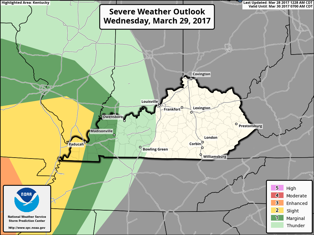
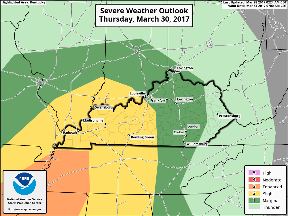
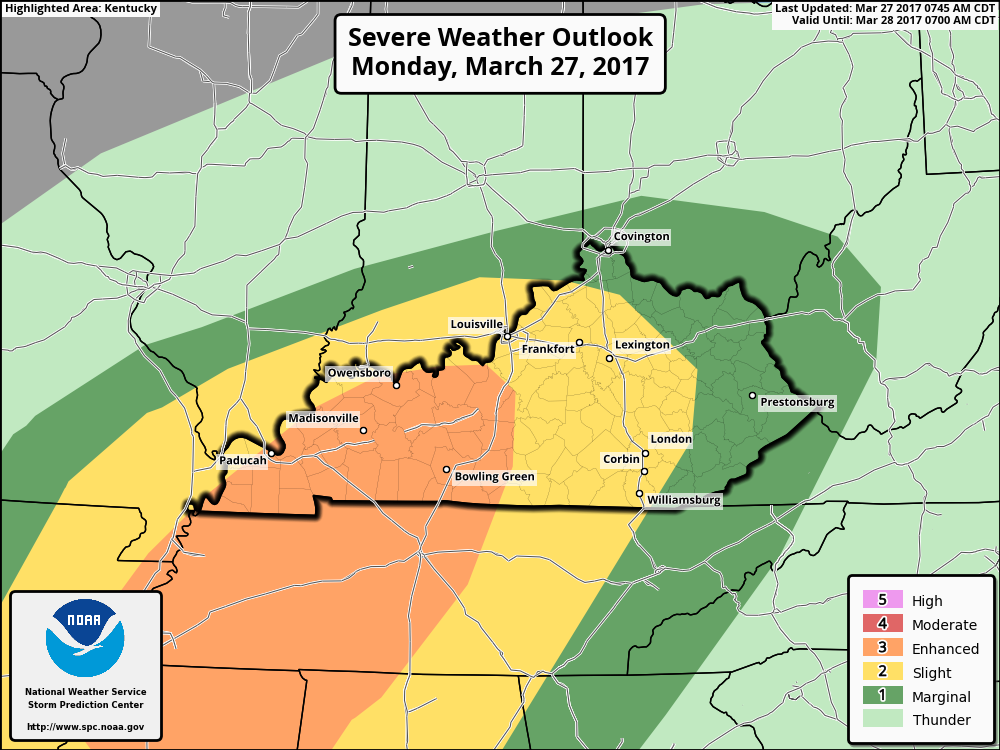
While some in WKY may see some strong to severe storms tomorrow the best bet to see these storms will be Thursday afternoon into the evening hours. The possible storms on Wednesday look to be linear in nature and have damaging winds and hail as the primary threats. Thursday's possible storms look to be more wide spread. The Storm Prediction Center has most of Kentucky in a Slight Risk Area for Thursday afternoon. This area is mainly from the I-65 corridor back towards the west. I expect WKY maybe moved into a category 3 Enhanced Risk Area and the category 2 Slight Risk Area extended eastward. Today my main areas of concern are WKY and NKY. These two areas could see supercell thunderstorms that could produce a tornado or two. I will update again in the morning on both days. Here are some maps for Thursday afternoon where most of my attention is directed.

-
Enjoy the break today from the severe weather. Strong to severe storms look to return Wednesday evening in WKY and then again on Thursday for most of the rest of the state. I will update later today because the service I use for my weather information is having server issues this morning. Just wanted to give everyone a heads up.
-
-
We had a brief period of pea size hail here in Richmond,KY.
-
The Watch for WKY has been canceled.
-
-
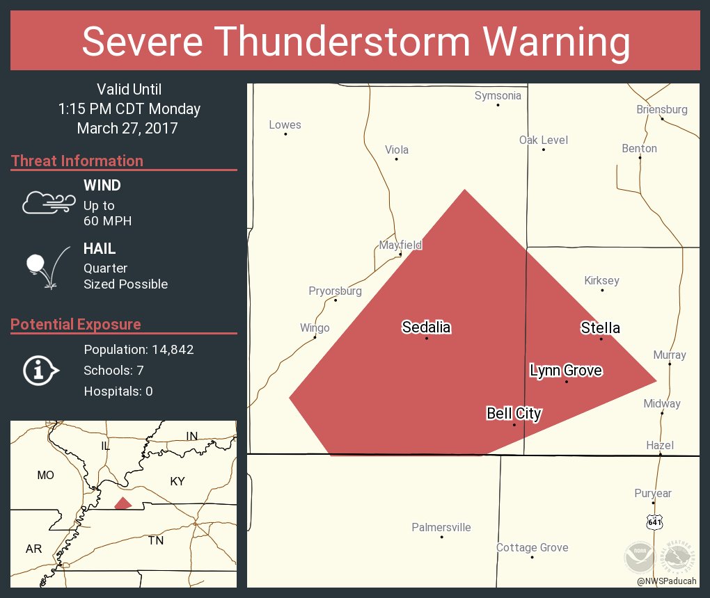
Severe thunderstorm warning for WKY.
-
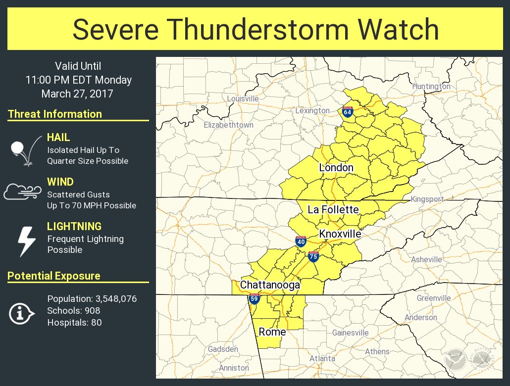
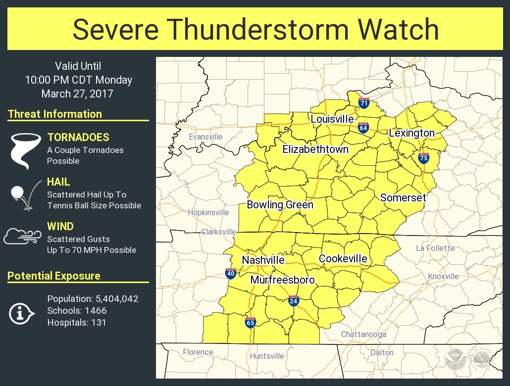
The NWS Storm Prediction Center has issued a * Severe Thunderstorm Watch for portions of Eastern Arkansas Western Kentucky Missouri Bootheel Northern Mississippi Western Tennessee * Effective this Monday afternoon and evening from 1205 PM until 800 PM CDT. * Primary threats include... Scattered large hail and isolated very large hail events to 2.5 inches in diameter possible Scattered damaging wind gusts to 70 mph possible A tornado or two possible SUMMARY...Severe thunderstorms will continue to develop within an increase moist and unstable air mass across the region. Mostly linear bands of severe thunderstorms will spread east-northeastward across northwest Tennessee into west-central Kentucky, while more isolated storms are expected across northern Mississippi into west-central Tennessee. Large hail and damaging winds can be expected, and at least some tornado risk could gradually increase through the afternoon. The severe thunderstorm watch area is approximately along and 70 statute miles east and west of a line from 30 miles south southwest of Oxford MS to 50 miles north northwest of Fort Campbell KY. PRECAUTIONARY/PREPAREDNESS ACTIONS... REMEMBER...A Severe Thunderstorm Watch means conditions are favorable for severe thunderstorms in and close to the watch area. Persons in these areas should be on the lookout for threatening weather conditions and listen for later statements and possible warnings. Severe thunderstorms can and occasionally do produce tornadoes.
-
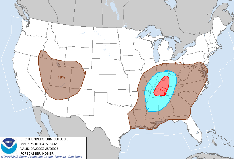
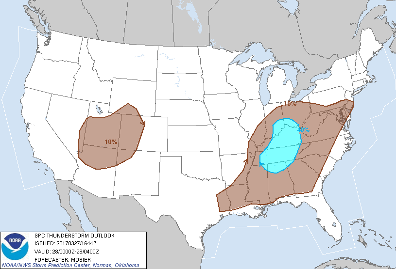
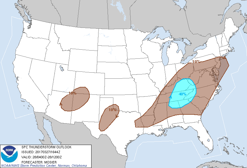
Thunderstorm outlook for this afternoon into Tuesday morning. All times are EDT. 4-8 pm 8 pm till midnight Midnight to 8am
-
No real changes to this mornings outlook. The tornado threat has diminished some but is still there.
-
A Severe Weather Watch maybe issued by 2 pm EDT for western and south central Kentucky.
-
I just received this from the NOAA NWS-Louisville office.
-
According to the latest HRRR simulated radar you'll be right in the middle of it. I'll update the timing around 12:30 pm EDT.
-
I forgot to mention that the Slight Risk Area has been moved eastward also.
-
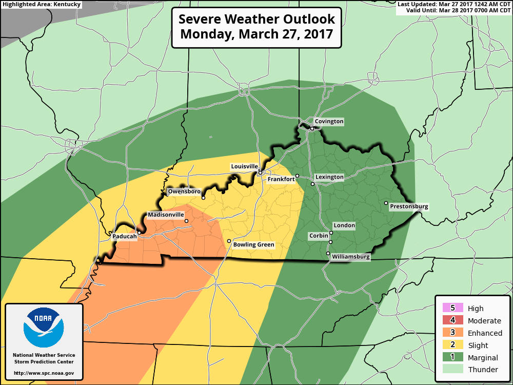
As I expected this morning the Enhanced Risk Area has just been expanded in KY.
-
Just took a look ahead to later in the week. Looks like we'll get a break on Tuesday then the possibility of strong to severe storms could return for parts of Kentucky starting on Wednesday into Thursday.
-
-
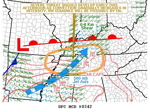
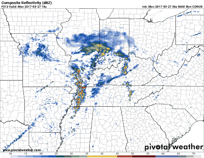
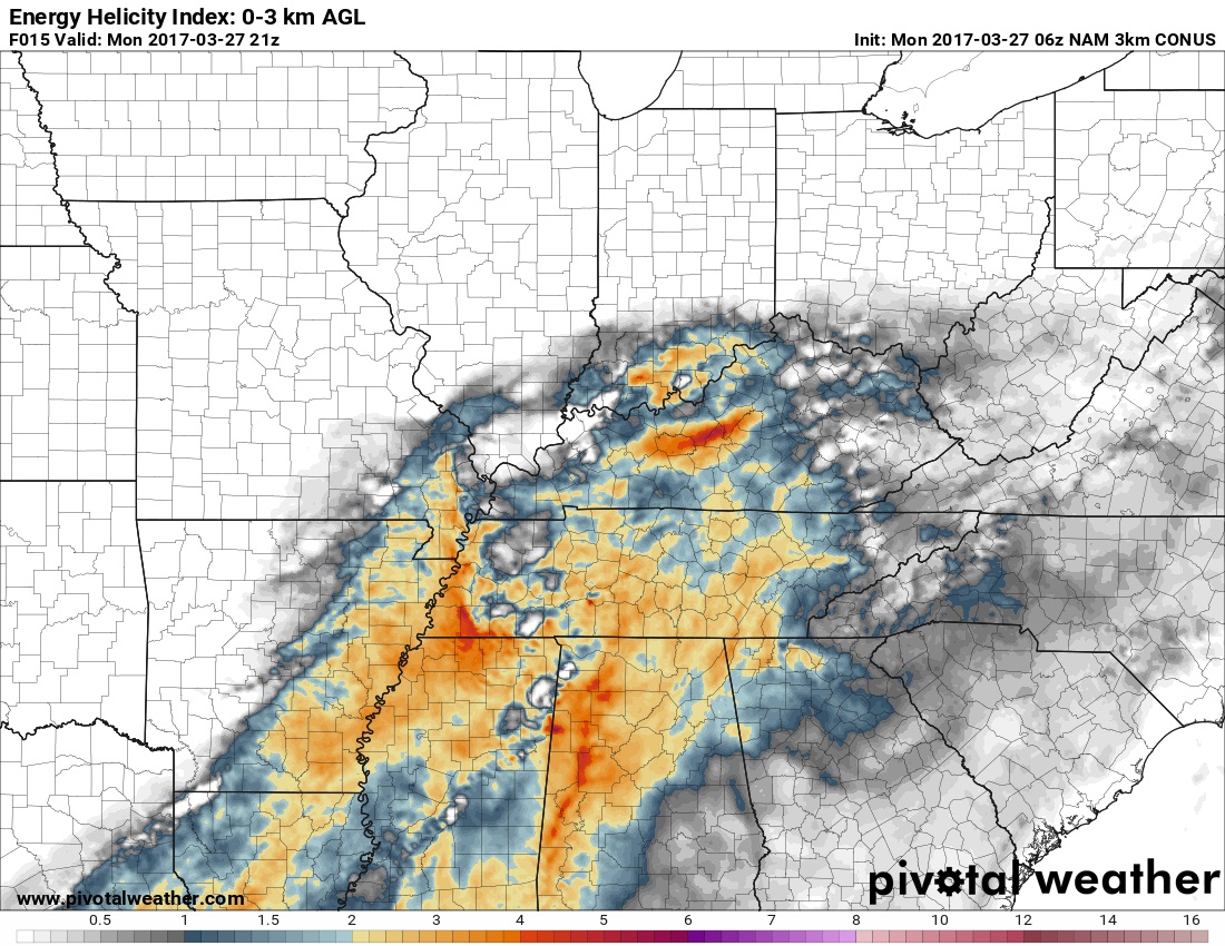
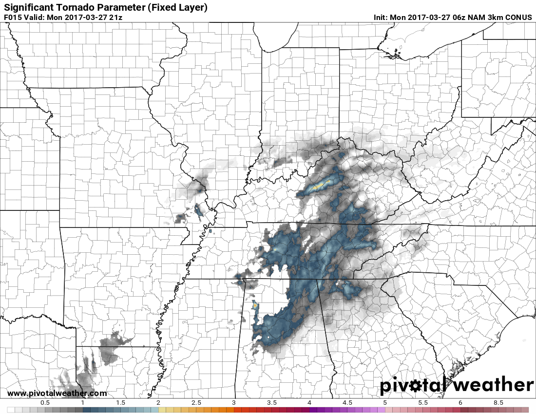
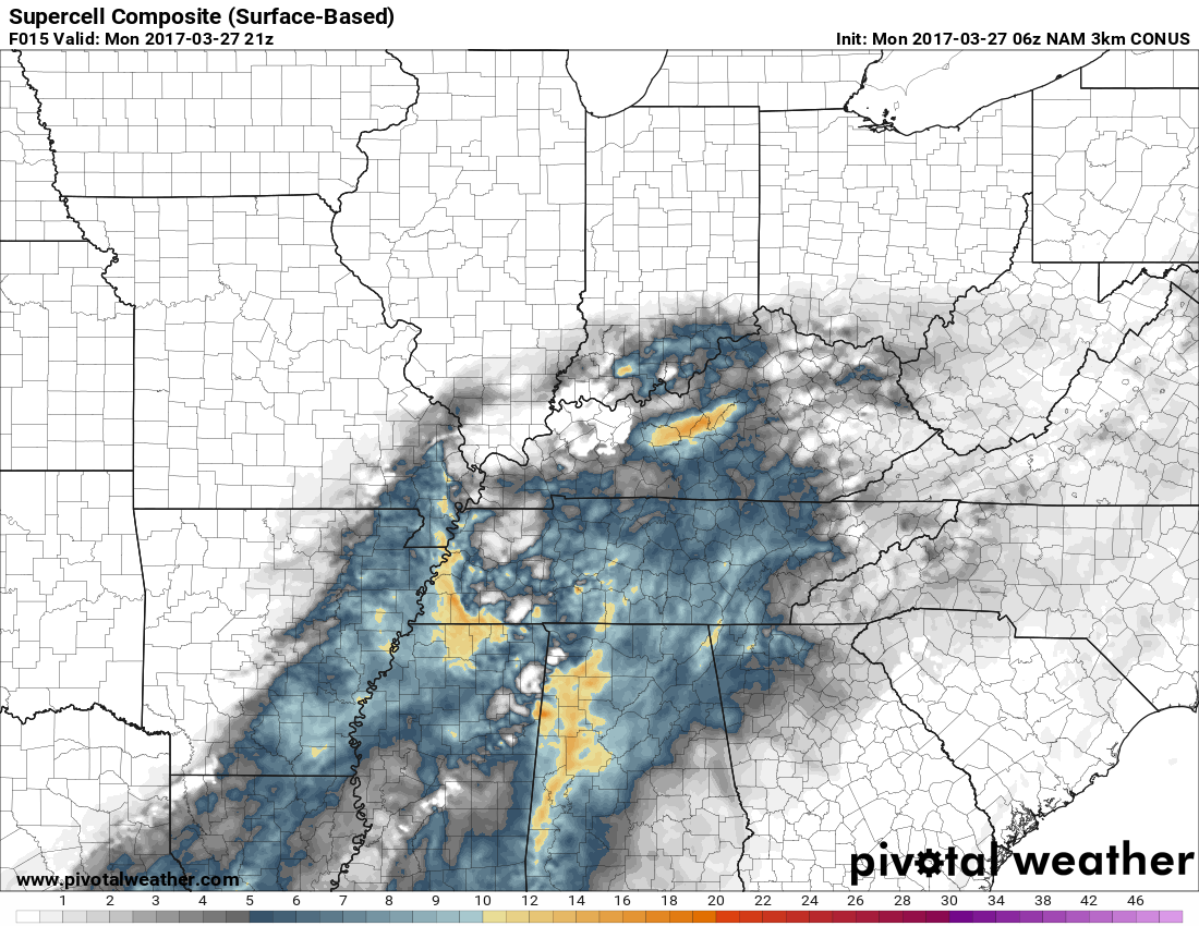
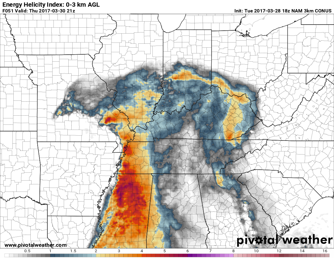
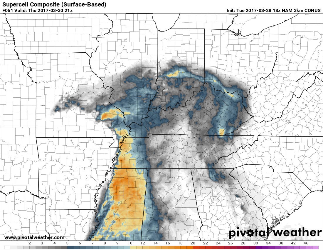
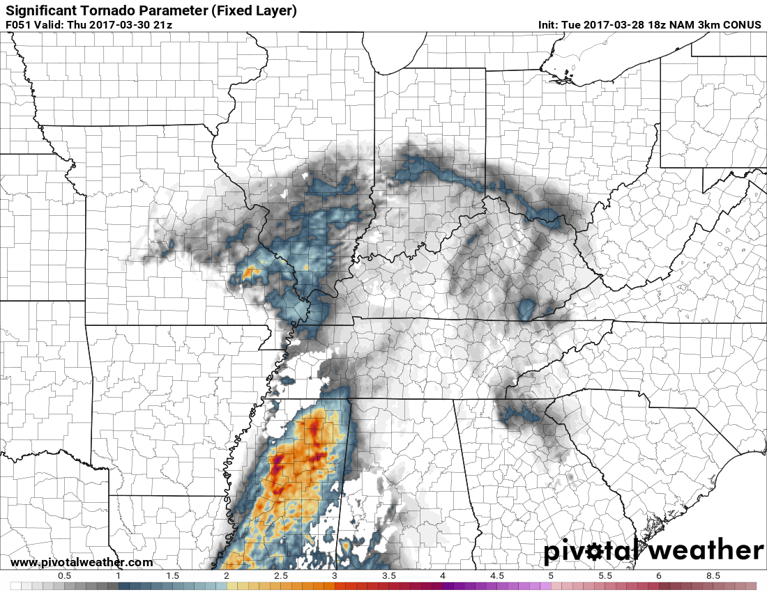
I'm issuing a Severe Weather Alert Day for today. Parts of Kentucky are now in a category 3 Enhanced Risk Area for strong to severe storms later this afternoon. Cellular clusters of supercells and organized multicells storms are forecast with hail (perhaps very large with the most intense storms). Damaging winds and a possible tornado or two. The main area of concern for me this morning looks to be centered on the Bluegrass PKWY from around Elizabethtown to Lexington. The 3km NAM is showing this area with the strongest possibility of a significant tornado or two. I wouldn't be surprised to see the Enhanced Risk Area expanded some later today. Now this doesn't mean that there will be one but the possibility is there. You can see that in the significant tornado parameter map below. For now the timing looks to be after 2 pm EDT and the best time for the possible strongest storms after 5 pm EDT. Everyone should be weather aware later today. I will post updates on here when I can. I will be updating on our twitter feed throughout the day.
-
I'm issuing a Severe Alert Day mode for later today. I'll be back in a few with a forecast of the possible severe weather.
-
Sunday evening update. The models are in good agreement for the chance of strong to severe storms Monday afternoon. The main threats look to be damaging winds, hail and maybe a tornado or two. After Monday's possible storms we look to get a break until the end of the week. Then the chance for strong to severe storms ramp up again. I'll update again the morning.
.gif.e2da7e4eb4ce318f222aada2f597078d.gif)