.png.ffa34568722b20f38e3c3ecfcb9a2cd2.png)


nWo
-
Posts
25,592 -
Joined
-
Last visited
-
Days Won
2
Everything posted by nWo
-
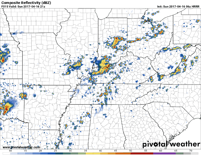
Sunday morning update. While the severe threat has diminished some will see some scatter showers and possible thunderstorms this morning. These look to clear out by late morning. There maybe some clearing before the cold front approaches Kentucky. This could ramp up the severe threat some. As surface heating takes place, weak instability is forecast to develop along the front. This combined with increasing low-level convergence should result in thunderstorm development. Scattered thunderstorm development is forecast to occur along and ahead of the front this afternoon. The severe threat looks to be isolated damaging wind gusts and hail as the primary hazards. 2-6 pm EDT 5-8 pm EDT

-
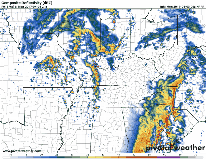
Saturday evening update: The 18z NAM is showing that the threat for severe weather has diminished but strong storms are still possible that could go severe. For now it looks to more widely scattered storms between the 2-5 pm EDT time period. Mainly in the Louisville, NKY and WKY areas. Western Kentucky could see a more organized strong to severe storm threat. Between the 5-8 pm EDT time period the storms look to shift to the central and bluegrass areas of Kentucky. A line should form from around Elizabethtown and could stretch to EKY. I will update again early tomorrow morning. The main threats look to be possible hail and damaging winds.
-
I have photo gray lenses that automatically transition into sun glasses.
-
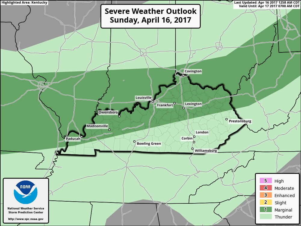
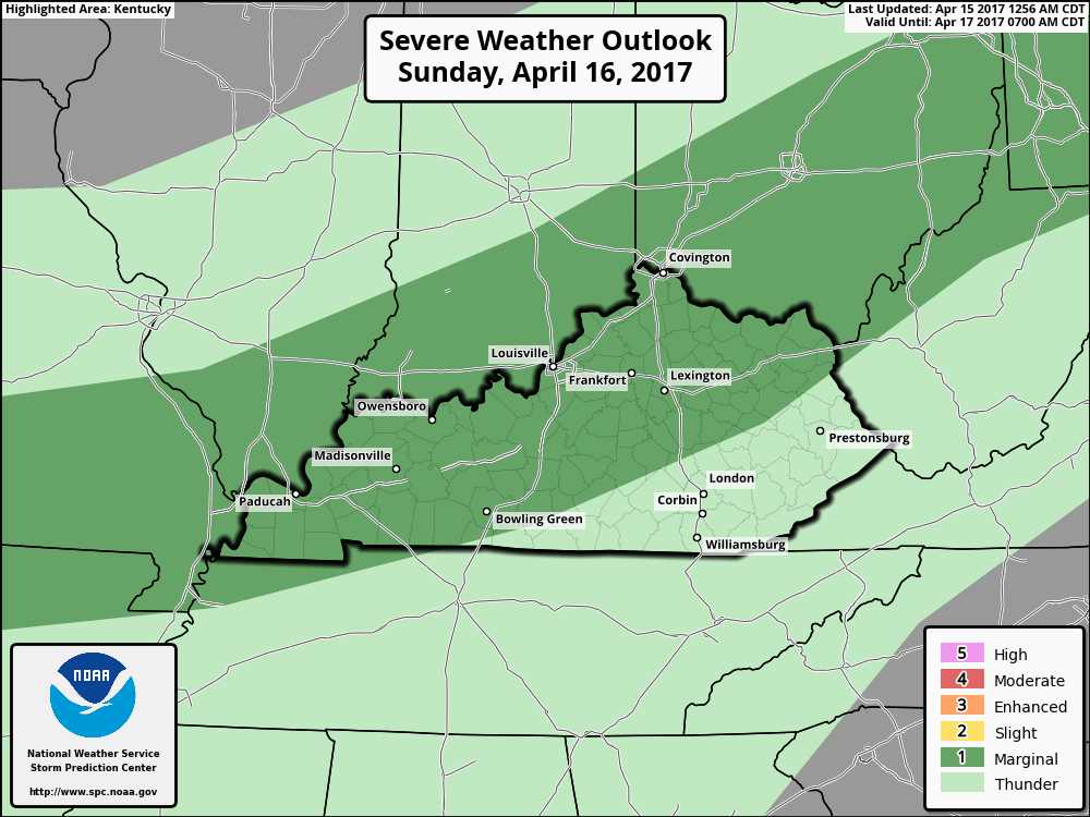
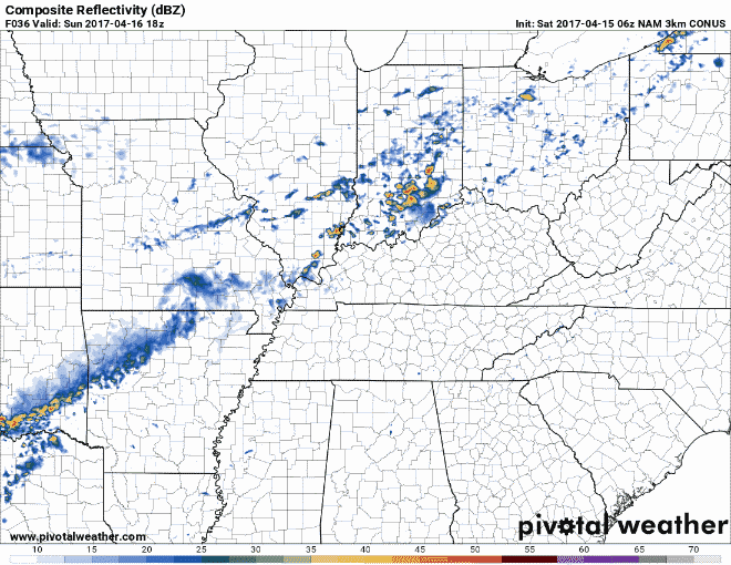
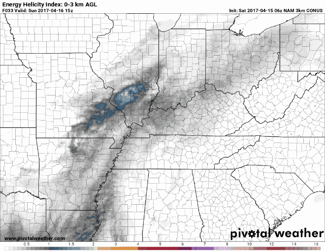
The Storm Prediction Center has parts of Kentucky in a Marginal Risk Area for possible strong to severe storms Sunday afternoon into the early evening hours. This area is north and west of a line from around Bowling Green into in and around the Ashland area. A cold front will push eastward across the Ohio Valley. Storms look to form along this front. Small to marginally severe hail and isolated wind damage may accompany the stronger storms. The main areas I'm watching for the possibility of these storms is from around Louisville to Cincinnati/NKY area. This is are area where the EHI model is showing the most instability. I will update later today. Those who have outdoor plans for Sunday afternoon should keep and eye on the weather in their area. May not be a total washout but be weather aware for these storms could pop up rather quickly. Radar from 2 pm to 4 am EDT EHI from around 11 am to 8 pm EDT
-

United Airlines Overbooks Flight, Then Drags Man Off Plane
nWo replied to Wireman's topic in Controversial Issues
This is how we should get ready to fly United! :thumb: -
Thanks for the compliments. I'm kind of mentally drained from yesterday. Just need a break from it for a little while. Don't worry. I'll still keep my eye to the sky.
-
I'm going to take a break. Tired from yesterday and last night. I'll be back soon.
-
Picture of marble size hail in Winchester.
-
Warnings too numerous to post on here best place to follow them is on our twitter page.
-
If you go I would have a plan ready. I've cancelled all my plans here in Richmond for tonight
-
Well I guess I'm a little late.
-
Another conference call is scheduled for 11:30 am EDT this morning. I will post an update afterwards. Thunderstorm outlook for later today. 12-4 pm EDT 4-8 pm EDT 8-12 am EDT
-
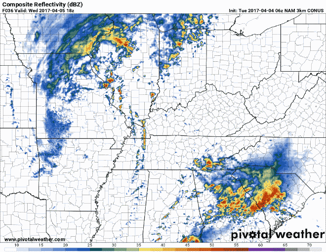
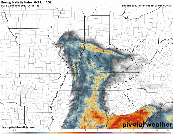
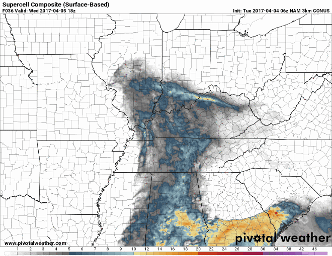
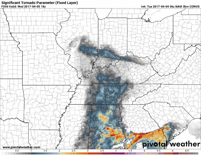
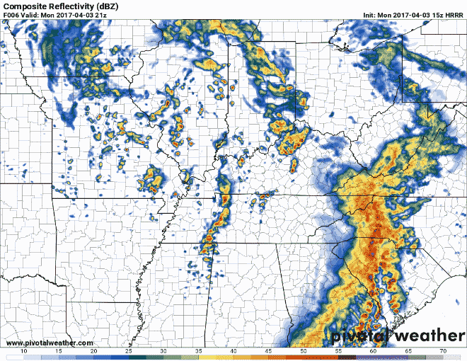
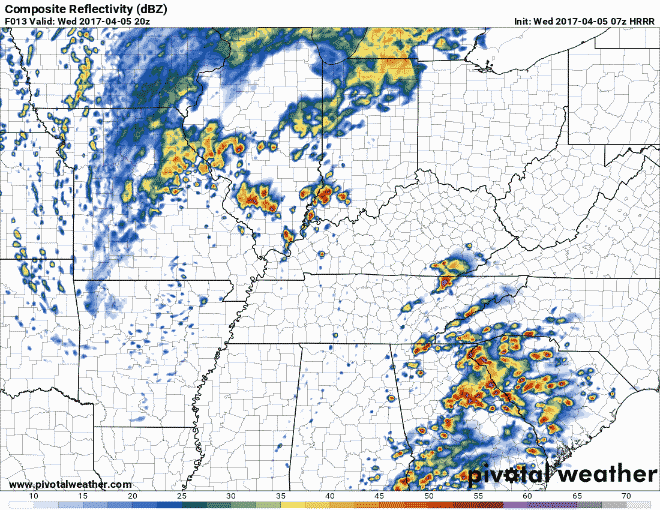
The Storm Prediction has moved the Moderate Risk Area into parts of Kentucky. This area is from just west of Bowling Green up to around Elizabethtown and then bordered on the east between Russel Springs and Somerset. An outbreak of severe thunderstorms is likely this afternoon. These will include supercell development with a risk for tornadoes, some of which will be strong and long-lived. Large to very large hail and damaging straight-line winds also appear likely. Let me say that everyone may not see these storms for it looks like there maybe only about 30% coverage as discussed in yesterday's conference call. That is indeed what the HRRR radar is showing. This morning that radar is showing the main areas seeing these storms will be just west of I-65 eastward. I would not be surprised to see the Moderate Risk area move to around the I-75 corridor later today. I'm seeing these storms firing up rather rapidly after 3 pm EDT. Everyone should be weather aware later today. Go over you emergency action plan this morning before the storms hit. I will post on here when I can. Follow our twitter feed for rapid updates and any warning being issued. Here are some maps to show everyone what I've looked at this morning.
-
Look for the storms to start around the 1-2 pm EDT time period. The possible storms could form and go severe rather rapidly so be alert. The Pigeon Forge area is in a Enhanced Risk Area for strong to severe storms.
-
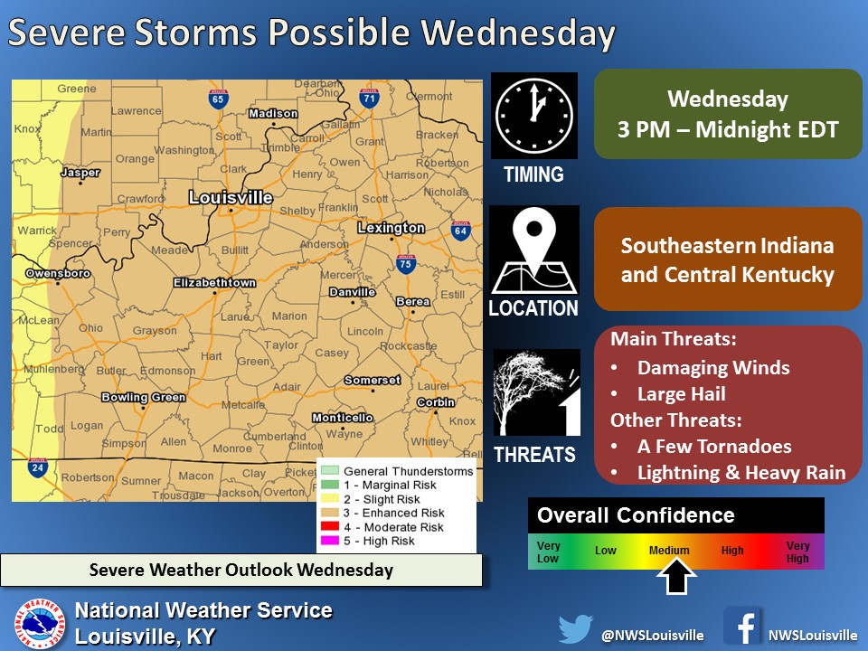
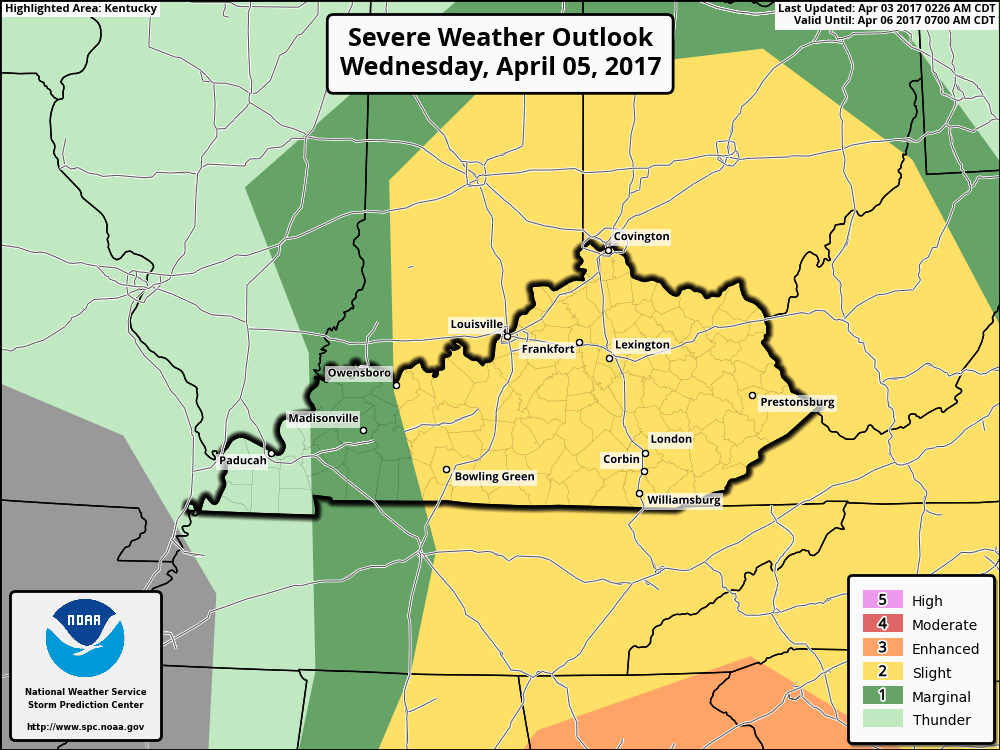
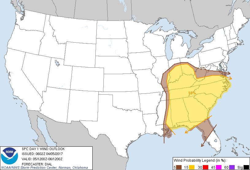
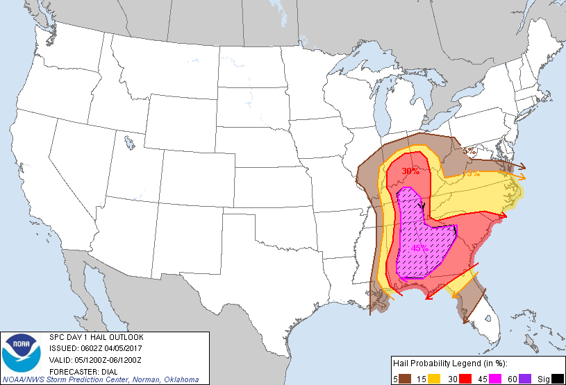
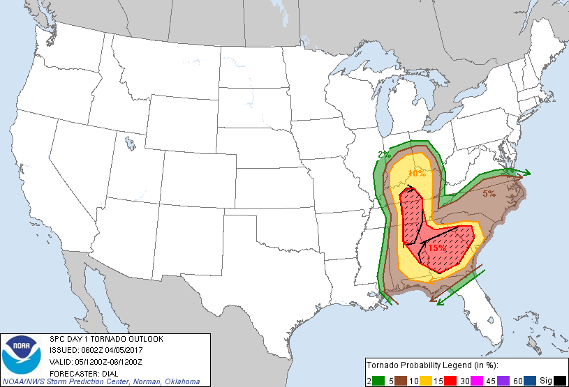
I'm issuing a Severe Weather Alert for Wednesday 4/5/17 for strong to severe storms. Timing is in the afternoon into the evening hours. Got some good information from this afternoon's conference call with the NWS-Louisville office. Scattered thunderstorms are likely to develop Wednesday afternoon west of I-65. Confidence is increasing for the potential for severe weather. The main threats look to be damaging winds, large hail, and a few tornadoes. The chance for hail is in the high category. The potential for golf ball size hail and above. The area with the best chance for tornadoes look to be along and east of I-65. This situation is more serious than the one last week. It is along the same lines as the one around March 1st. It was also mentioned that parts of Kentucky should see some sunshine and that people should allow that a reason to lower your guard. Any cloud cover could limit the severe potential in that area. It was also mentioned that the April 3,1974 and the outbreak in 2012 started out as sunny days. Not let me say this. This DOES NOT MEAN, that we will see anything like those two events just that the setup will be similar. The Storm Prediction Center has moved the Enhanced Risk Area line a little further west than this morning. Also the SPC may move the Moderate Risk Area closer if not into Kentucky tomorrow. I will update more in the morning. Everyone should be going over their Emergency Action Plan today in case the severe weather comes to fruition.
-
Thanks for the compliments. FYI for everyone. There's a conference call by the NWS-Louisville office at 2:30 EDT. About the possible severe weather on Wednesday I'll try and post the information as soon as I can.
-
I just received this from the NWS-Louisville office.
-
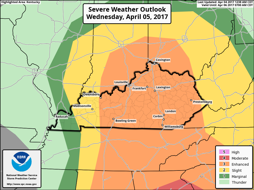
The Storm Prediction Center has most of Kentucky in a category 3 Enhanced Risk Area for strong to severe storms. This area is east of a line from around Owensboro south to just west of Russellville. West of that line the rest of Kentucky is in either a Slight or Marginal Risk area. Confidence is is increasing tha the environment will become conducive to discrete supercell storm development initially. The expected risks are large hail, damaging winds and a few tornadoes, some of which could be strong and long lived. Eventually the storms may develop into growing line or clusters of storms accompanied by a more substantial risk for damaging wind gusts. My main areas of concern are in and along the I-65 corridor from Central and Southern Indiana down to about Bowling Green and in the Cincinnati/NKY area. For now these areas seem to have the best chance to see tornadic supercell development. Other parts of Kentucky can see the possibilities of these type of storms to develop so everyone should be weather aware on Wednesday. For now the timing looks to be from around late afternoon into the evening hours. Probably from around the 4-8 pm EDT time period. I'll probably will go into a Severe Weather Alert later this evening. Check back for updates
-
sorry didn't see this till now. Parade should be fine. The precipitations is looking to move in earlier than expected this morning. Rain could be in the Cincinnati area by around 5 pm or so then be out with lingering drizzle by around 8 pm.
-
This event happened 43 years ago today. The Tornado Outbreak of 1974. April 3, 1974
-
The SPC has increased the threat level for strong to severe storms for Wednesday to a category 2 Slight Risk area. For now this area is east of a line from Owensboro to around Russellville. Organized severe development looks to be possible over a fairly broad area. The risk could be discrete supercell storms mainly late Wednesday afternoon into Wednesday evening. I can't post any maps this morning because the National Centers for Environment Prediction has been having slowdowns with their servers. Hopefully I'll be able to post some later today. Keep checking back for updates.
-
The SPC still has most of Kentucky in a Marginal Risk Area for strong to severe storms for today. The severe threat has lessen some since yesterday but there could still be some to pop up later today. There could be some widely scattered multicell and maybe some supercells to develop. Marginally severe hail and damaging winds will be the primary threats during the afternoon before they start to weaken during the evening.
-
The start of the game today should be ok. Precipitation looks to be moving in a little faster than what the models have been showing. Could see some shower/rain by around 7 pm.
-
I'll do what I can. :thumb: I'll update in the morning no real changes in the afternoon info.
-
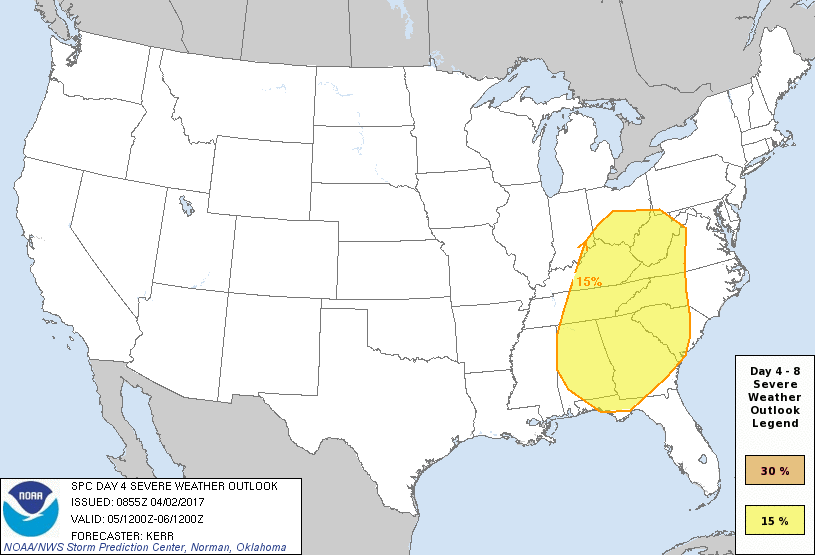
Sunday morning update: The Storm Prediction Center now has parts of Kentucky with a chance of strong to severe storms Wednesday into Thursday. Conditions could be favorable to support a considerable organized severe weather potential, including evolving storm cluster and supercell activity. Severe wind gusts and tornadoes will be possible with the strongest activity, along with a risk for large hail. I look for the threat level for this time period to grow and the SPC will upgrade the probabilities with their following outlooks. Keep Checking back for updates.


.png.55ab5fcf71a58dcc2a325876f3b73625.png)