.png.ffa34568722b20f38e3c3ecfcb9a2cd2.png)

.jpg.dff87640c6ed93f4bdf8eebdf96f5dec.jpg)
nWo
-
Posts
25,628 -
Joined
-
Last visited
-
Days Won
5
Everything posted by nWo
-
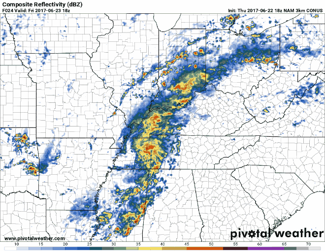
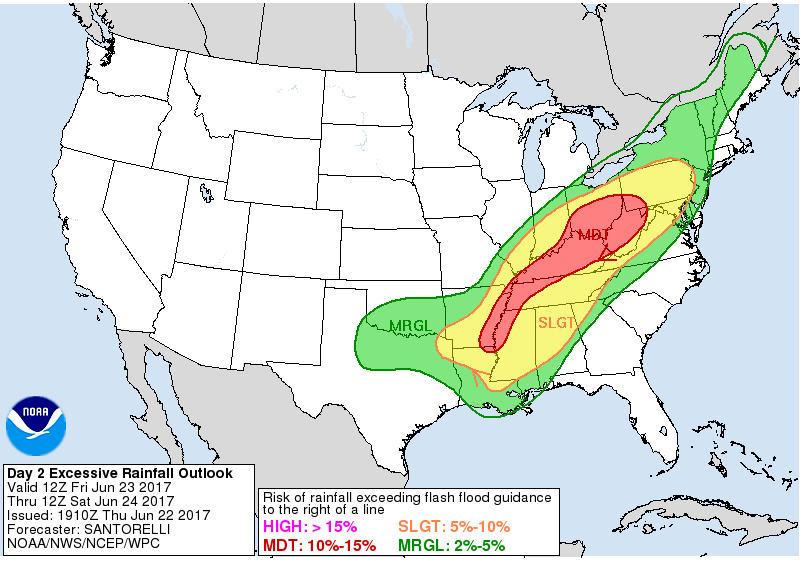
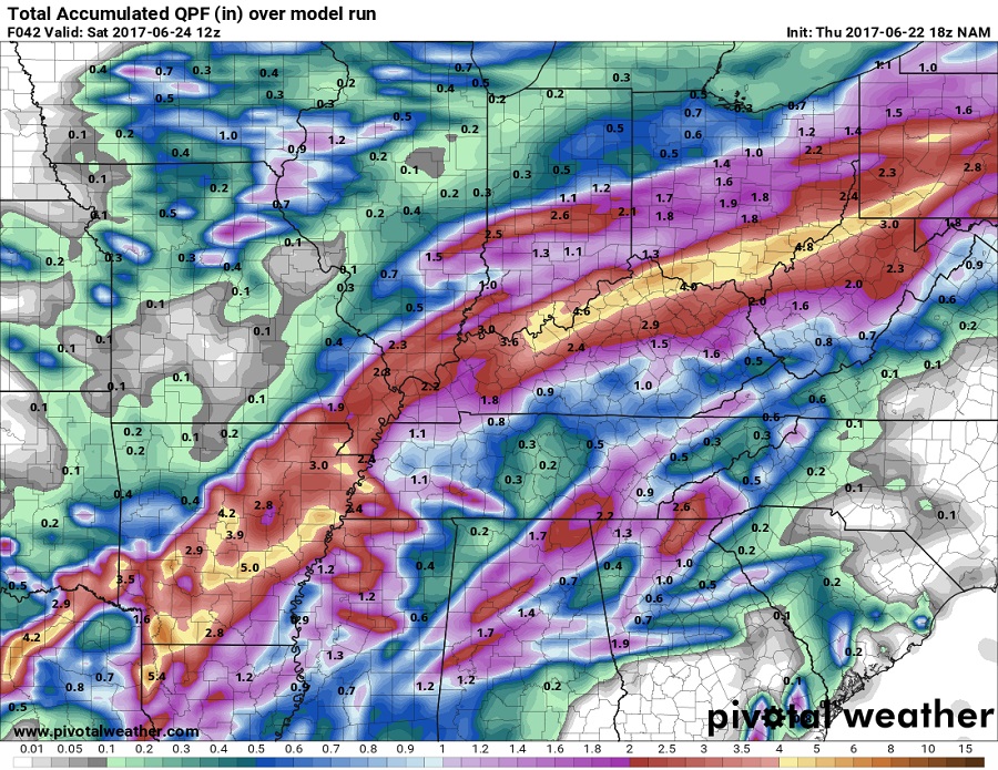
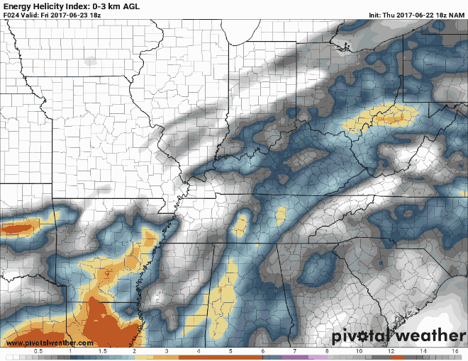
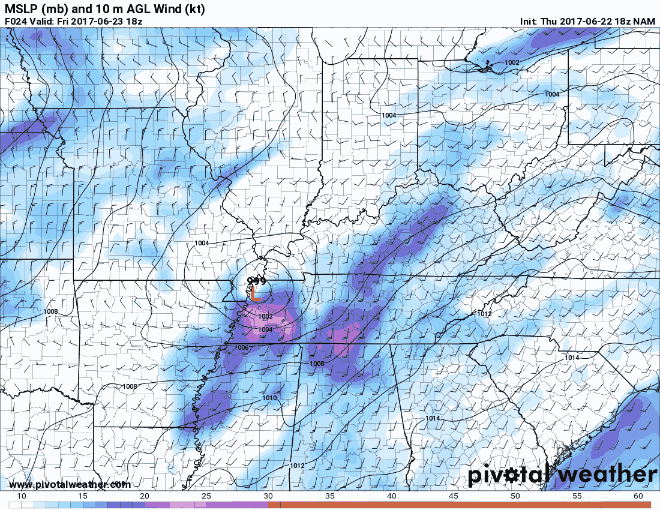
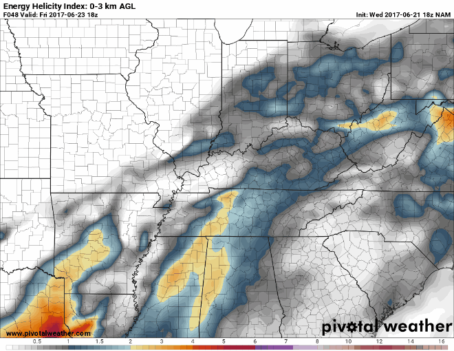
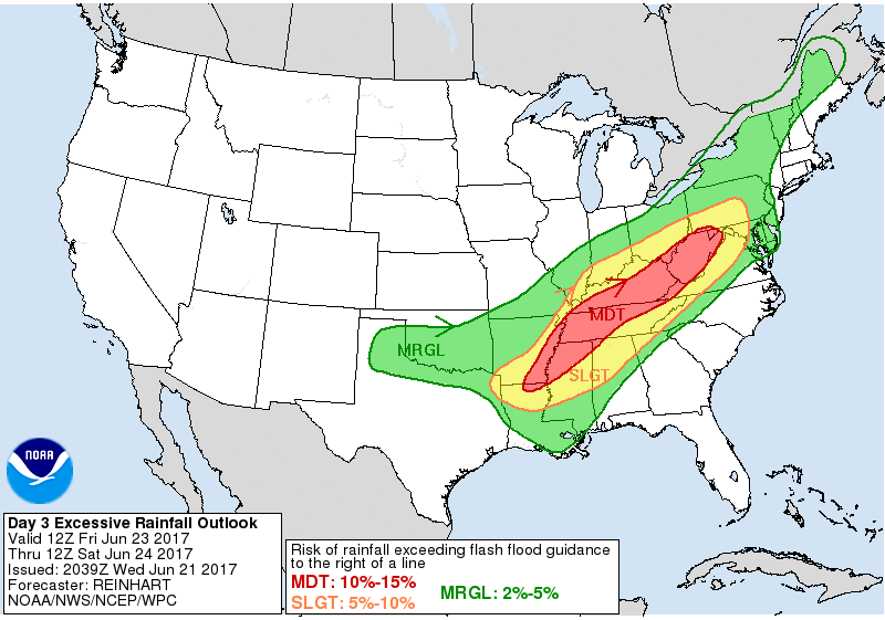
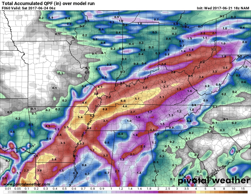
Thursday evening update: The Storm Prediction Center has expanded the Slight Risk Area for strong to severe storms for Friday. Thunderstorms could effect parts of Kentucky Friday into Friday evening, accompanied by a risk for potentially damaging wind gusts and perhaps a few tornadoes. The timing, at the moment, for the possible severe storms looks to be between 2-8 pm EDT for those in the Slight Risk Area. Most, if not all of Kentucky is now under a Moderate Risk for rainfall that could exceed flash flooding criteria. The entire state is now under a flash flood watch 8 am EDT Saturday morning. The heaviest accumulation band has been moved northward. It looks like 4-6" of rain could fall from around Owensboro northeastward to around Maysville throught 8 am EDT Saturday morning. This simulated radar shows the heaviest precipitation as it moves across the state from around mid afternoon into the night time hours. This shows the system that was once Cindy move across Kentucky on Friday. I will post an update in the morning. Remember,"Turn around, Don't Drown."

-
Flash Flood Watch for WKY until Friday evening. ...FLASH FLOOD WATCH IN EFFECT FROM 1 PM CDT THIS AFTERNOON THROUGH FRIDAY EVENING... The National Weather Service in Paducah has issued a * Flash Flood Watch for portions of southern Illinois, southwest Indiana, western Kentucky, and southeast Missouri, including the following areas, in southern Illinois, Hardin, Massac, and Pope. In southwest Indiana, Spencer and Warrick. In western Kentucky, Ballard, Caldwell, Calloway, Carlisle, Christian, Crittenden, Daviess, Fulton, Graves, Henderson, Hickman, Hopkins, Livingston, Lyon, Marshall, McCracken, McLean, Muhlenberg, Todd, Trigg, Union KY, and Webster. In southeast Missouri, Mississippi and New Madrid. * From 1 PM CDT this afternoon through Friday evening * Scattered thunderstorms will likely develop this afternoon. Any storms will be accompanied by tropical downpours. A more organized area of heavy rain is expected to arrive tonight and continue through Friday. Rainfall amounts through Friday will likely average from 2 to 4 inches in the watch area. Locally higher amounts are possible where thunderstorms are persistent. * High rainfall rates could lead to rapid inundation of flood- prone roadways. Sharp rises in creeks and small streams may occur. Low-lying areas may quickly become flooded. PRECAUTIONARY/PREPAREDNESS ACTIONS... A Flash Flood Watch means that conditions may develop that lead to flash flooding. Flash flooding is a very dangerous situation. You should monitor later forecasts and be prepared to take action should Flash Flood Warnings be issued.
-
I will post a detailed update for you guys later today.
-
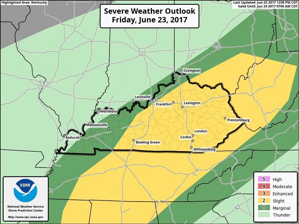
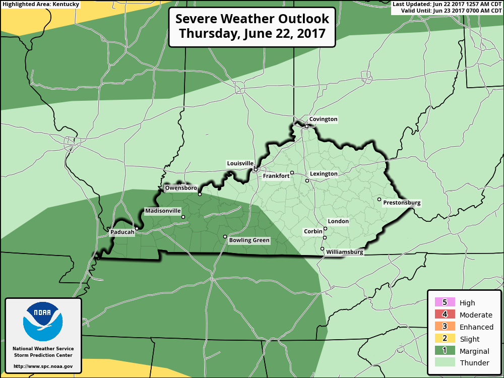
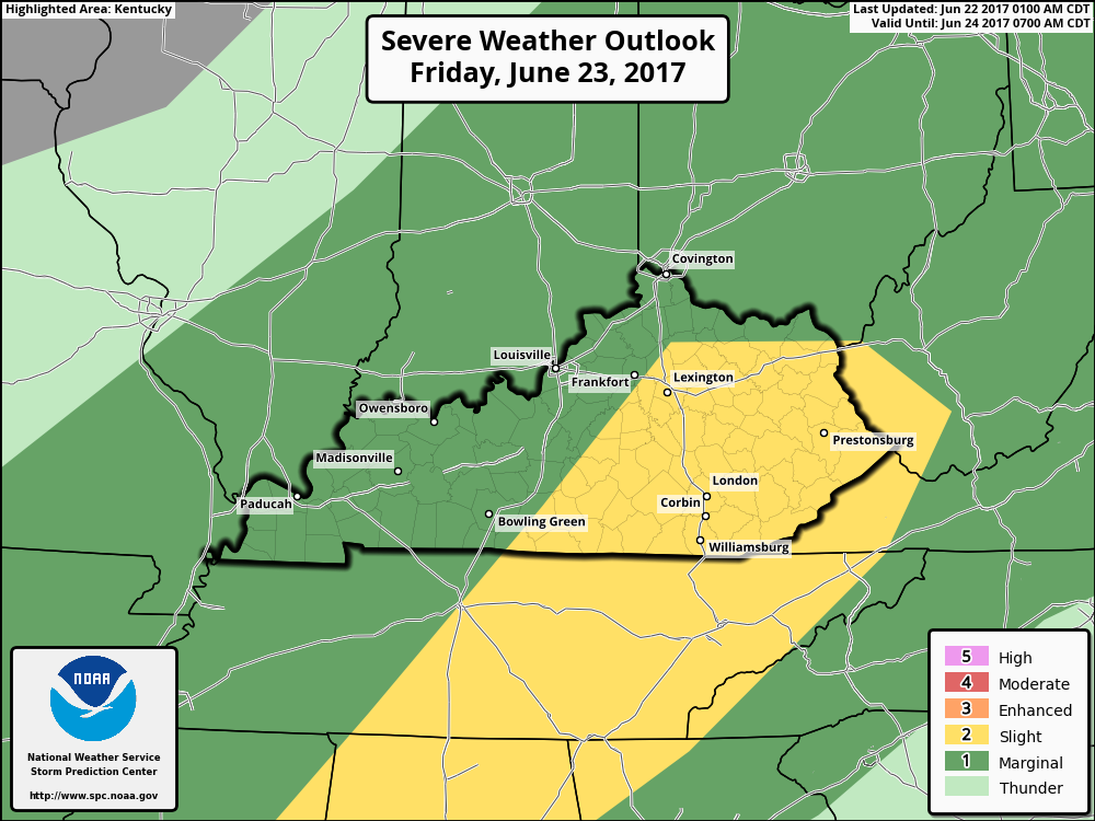
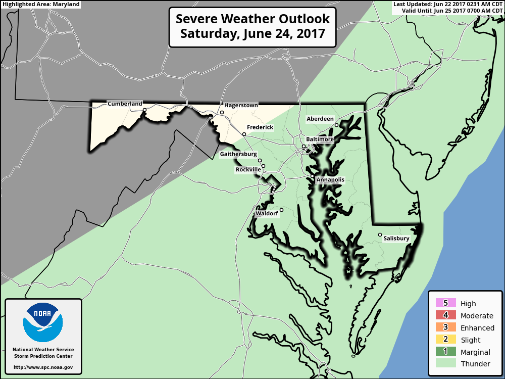
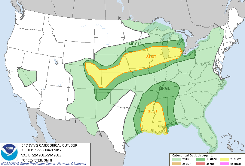
I'm issuing a Severe Weather Alert starting this afternoon into early Saturday morning. With the remnants of Cindy looking the past through Kentucky parts of the state is in a Marginal Risk Area for today. Tomorrow the threat ramps up with the possibility of strong to severe storms . The Storm Prediction Center has parts of Kentucky in a Slight Risk Area for strong to severe storms mainly east of I-65 and from just north of I-64 southward. Friday look for storms that could produce a few tornadoes ans strong to damaging wind gusts. As of now it looks like the best time for these storms will be Friday afternoon and evening. I will post an update later today. Everyone should be weather aware from now through early Saturday morning.
-
For now looks like through West Virginia then Pennsylvania in the direction. The accumulation amounts will lessen with 1-2" possible. Mainly just thunderstorms. No severe weather is expected in that area at this time.
-
This shows what is headed in our direction.
-
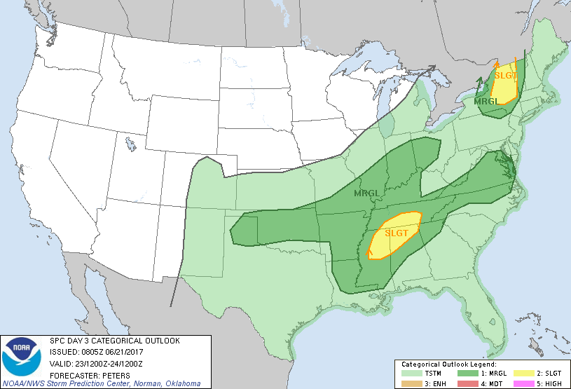
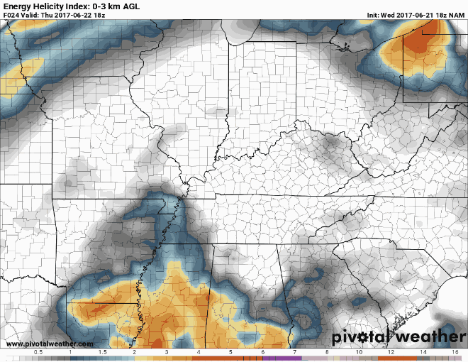
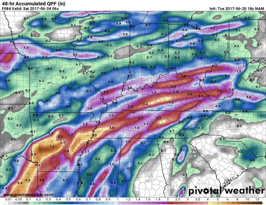
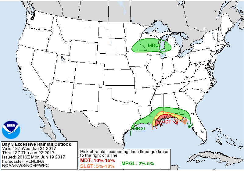
Wednesday evening update. Starting Thursday afternoon parts of western Kentucky could see strong to severe storms from the remnants of Cindy. The severe threat then moves eastward on Friday. The Storm Prediction Center has parts of Kentucky on both days in a Marginal Risk Area for strong to severe storms. Parts of Kentucky are now in a Moderate Risk Area for rain fall exceeding flash flood criteria on Friday. Parts of western and southcentral Kentucky could receive upwards to 7" of rain by late Friday night. There appears to be a wide swath of 3-5" of rain for the rest of Kentucky. Southeast Kentucky 1-2". All of this depends on the final path of the storm. This looks to be a life threatening situation for some parts of Kentucky. Those who live near river and streams should start preparing now for the possible flooding. I may go into a Severe Weather Threat Mode in the morning if the data continues to point in that direction.
-
I wouldn't be surprise at all if flights being delayed CVG is looking at around 3" of rain.
-
I'll post an update later as soon as I can. I'm a little pressed for time right now.
-
I took just a quick glance. The NAM looks like 2-3" in SEKY. The GFS says about the same. Let me say this if the system shifts to the south, and it won't take much of a shift you could be looking at anywhere from 4-6" of rain.
-
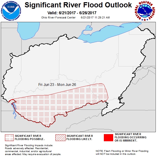
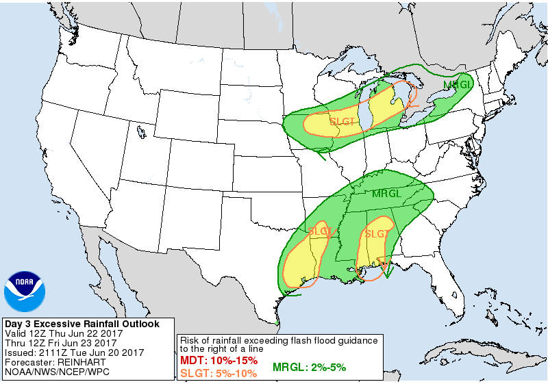
The Weather Prediction Center has now moved Kentucky in a Slight Risk Area for excessive rain. The National Weather Service has much of Kentucky with a possible chance for significant river flooding this weekend.
-
I really don't see how. Just took a quick look at the latest NAM forecast for rain accumulations. In the Danville area it is showing 4-5" of rain by 7 am EDT Saturday morning. Much of that falling in a 24 hour period. Almost 6" over the entire weather event. I'll post a more detailed forecast later this evening.
-
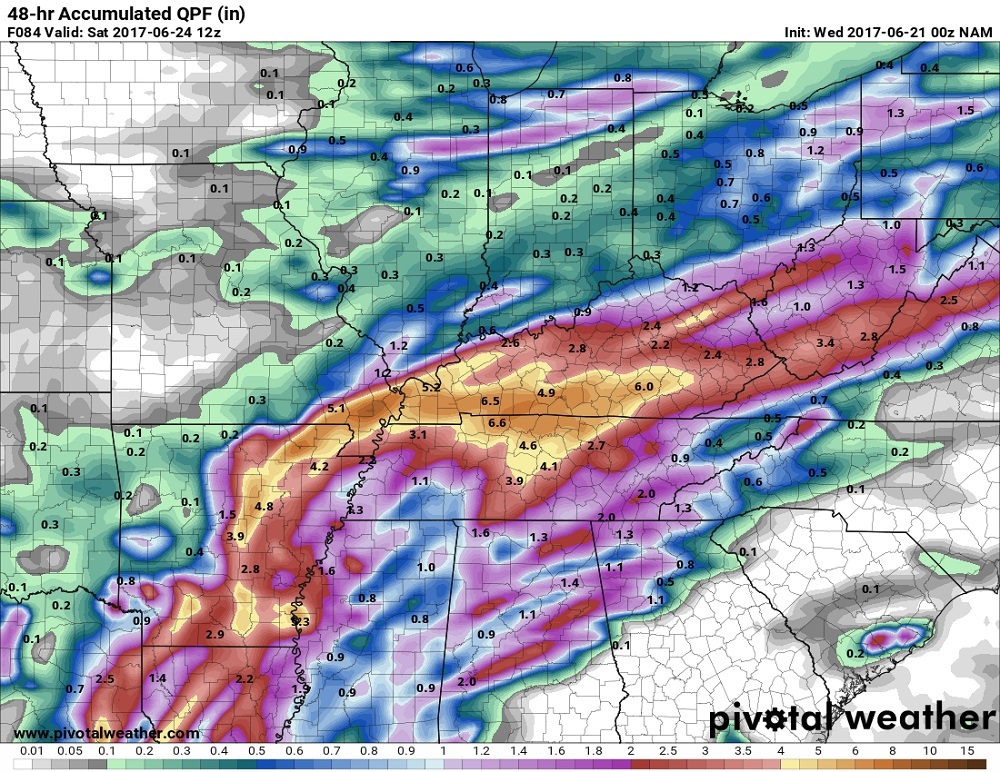
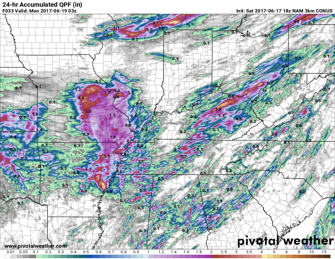
Rain fall totals for much of Kentucky has gone up with the latest NAM model run. Flooding looks to be a real issue this upcoming weekend. Very heavy rain is possible over much of Kentucky with the remnants of Tropical Storm Cindy passing over Kentucky. Widespread 2-5" will be possible. This runs shows some may be upwards to 6". I will update later.
-
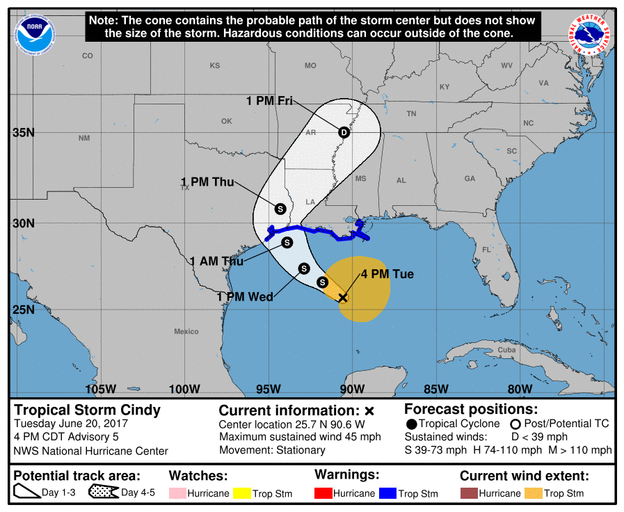
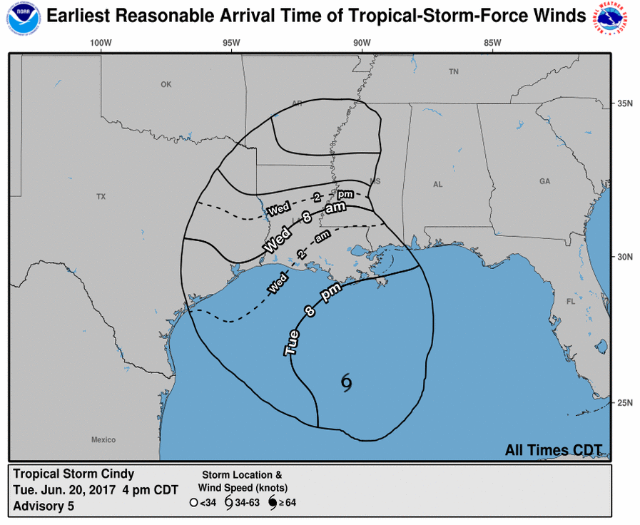
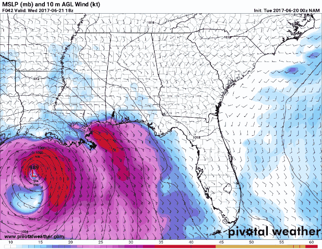
The storm formally known as Invest 93L is now Tropical Storm Cindy. The remnants of Cindy could affect our weather this weekend. Here is what the NAM is showing for precipitation accumulations for parts of Kentucky. Some could see upwards to 5" of rain. Flooding will be a concern with that much rain falling. I will update in the morning.
-
Bret has fizzled out and is no longer a tropical storm.
-
-
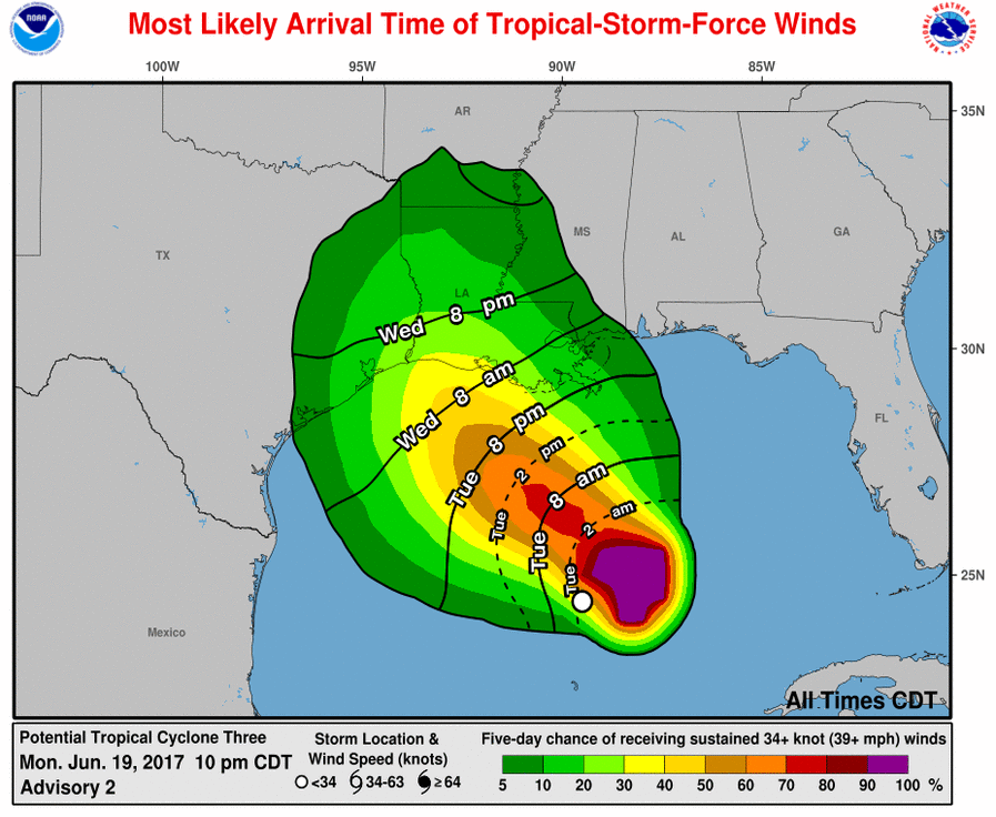
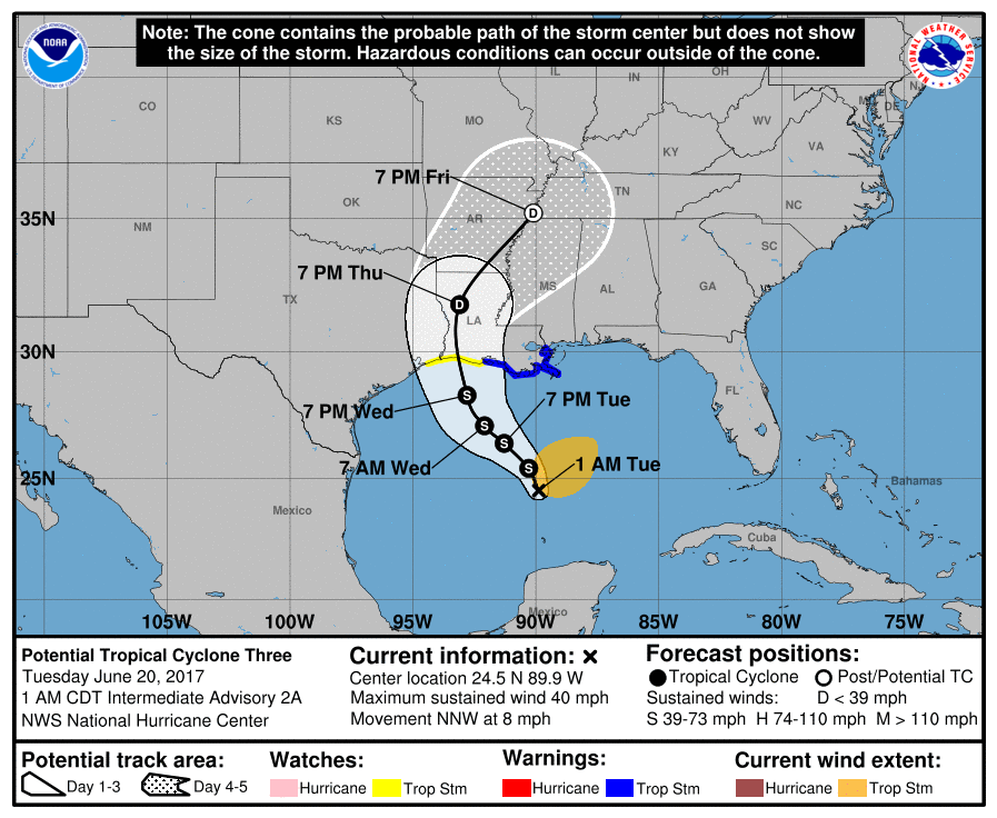
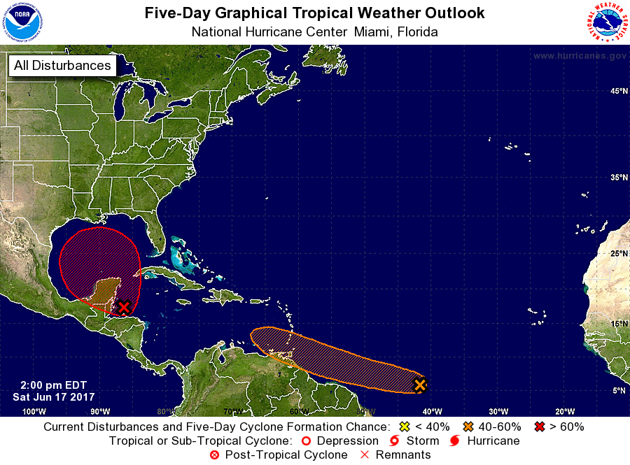
Update on Invest 93L. It may become a tropical storm today. If it does I believe it will be called Cindy. Those from Texas to the Florida Panhandle should pay attention to this storm. There is a possibility of these storm slowing somewhat and strengthening. By landfall maybe just below a category 1 hurricane. Update later today.
-
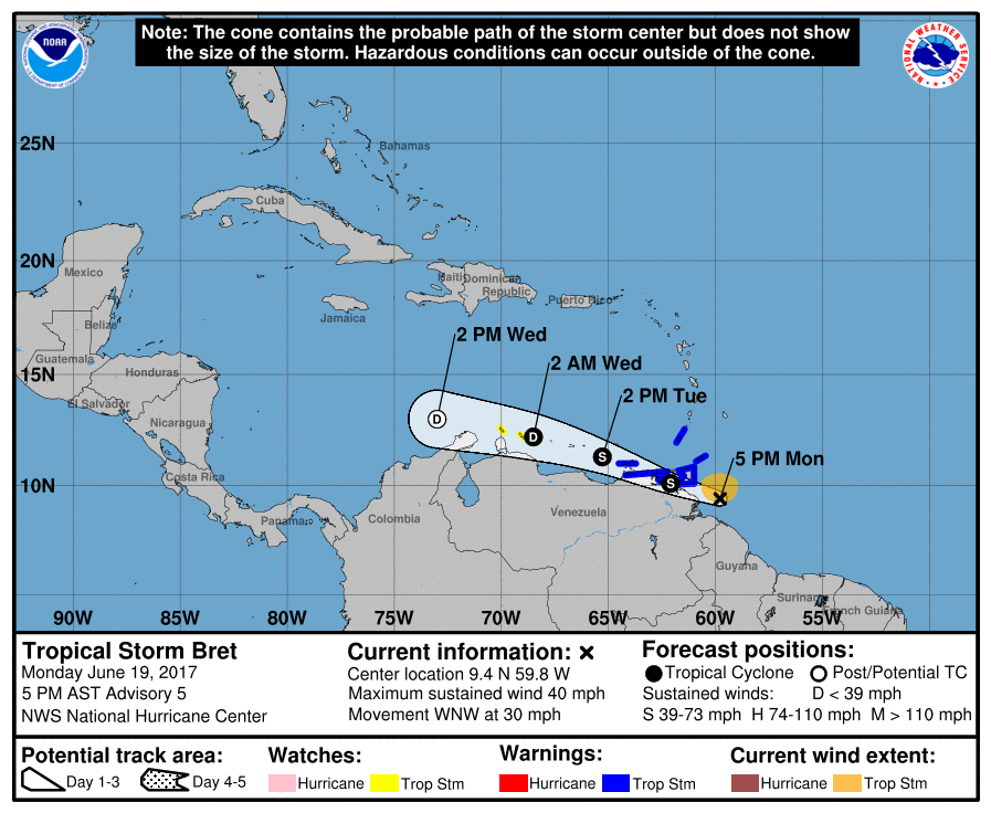
The system behind Invest 93L has become a tropical storm. It is named Bret. It is still about a week away before we know if it will hit the U.S. I will be posting updates as needed.
-
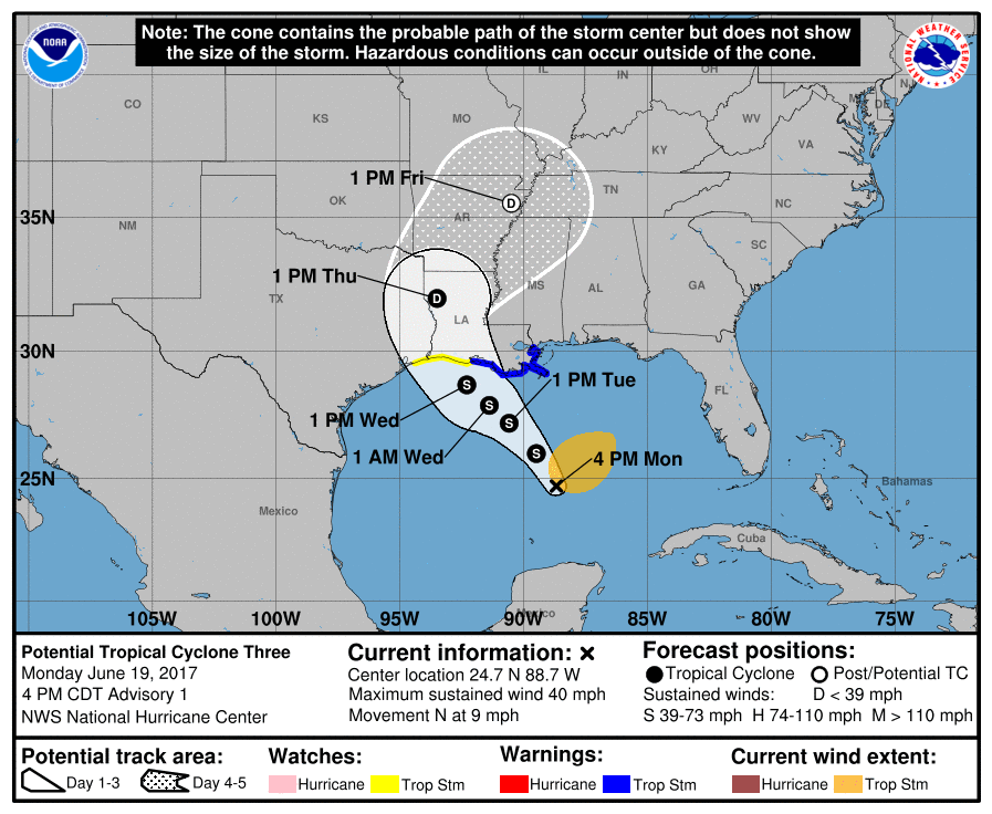
First let me make a correction. The map I posted this morning wasn't the correct one for Invest 93L. It was for the second system. My apologies for any problems my mistake may have caused. Monday evening update. Invest 93L may become a tropical storm soon. This system looks to make landfall in the Louisiana area. The following maps show its predicted track and tropical storm warnings for the Louisiana coast.
-
There still is an uncertainty to the track of the system number 1 which is Invest 93L. The modeling data has one track going toward Flordia and one has it going towards Texas. The National Hurricane Center maybe sending a Hurricane Hunter aircraft out today. Here is a map for the next few days. I will be keeping a close eye on it for you.
-
.thumb.jpg.dc448957daf4ddf2823660190e844abb.jpg)
Severe Thunderstorm Watch for parts of WKY till 10 am EDT(cancelled)
nWo replied to nWo's topic in BGP Break Room
This Watch has just been cancelled -
No real changes in the morning update. One thing of note this mornings activity may limit some of the severe development later today. The severe potential is still there. The main threats look to be damaging wind gusts and small hail in the stronger storms. Timing around mid afternoon to early evening. Note the simulated radar that after the line of storms past towards the east some more storms pop up behind it. 1-2 inches of precipitation will be possible with some areas maybe getting upwards to 3". This is causing the potential for flash flooding later today.
-
Radar from 9 am to 1 pm EDT
-
Saturday evening update. Things could get going around the 11 am EDT time slot especially in the NKY area. A line of storms will move southeasterly through NKY from around around 11 am to 2 pm EDT. Then a second line should form during the late afternoon and transverse across the state from around 5 pm to 8 pm EDT. The main threats look to be damaging wind gusts and flash flooding. Some hail could be seen in the areas with the strongest updrafts. Rainfall totals look to be mainly 1-2" from around just east of the I-65 corridor eastward into EKY. Totals could be higher under the stronger storms. Some could see upwards to 3". The tornado threat has diminished but there is still a small chance especially in NKY. Check back for an update in the morning. 24 hr rainfall totals through 11 pm Sunday night. Most of this will fall Sunday afternoon into the early evening hours. Flash flooding will possible.
-
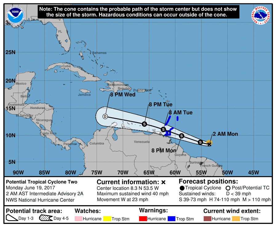
The National Hurricane Center is scheduled to send Hurricane Hunter Aircraft to investigate the system in the NW Caribbean Sea on Sunday afternoon. If they do the system will be call Invest 93L. This would be the storm where the possible 5 day development track is in red.