.png.ffa34568722b20f38e3c3ecfcb9a2cd2.png)

.jpg.dff87640c6ed93f4bdf8eebdf96f5dec.jpg)
nWo
-
Posts
25,628 -
Joined
-
Last visited
-
Days Won
5
Everything posted by nWo
-
-
Severe Thunderstorm Watch maybe issued soon. The chance of one being issued is 80%. I don't know when I'll be able to post another update on BGP so updates will be sent out on our twitter feed until I can get back on here. Everyone be weather aware later this afternoon. http://bluegrasspreps.com/bgp-break-room/bgp-com-weather-342822.html

-
There is a possibility for strong to severe storms this afternoon for most of Kentucky. The Storm Prediction Center has most of Kentucky in a Slight Risk Area for today. A cold front will advance into the Ohio Valley this afternoon. Ahead of this front, a warm, humid air mass will exist to support the development of numerous showers and thunderstorms in mainly multiple band from around midday into the early evening hours. Damaging winds and hail maybe possible. There is also a small threat for a tornado or two. Follow any possible warnings on our twitter page. 11 am-3 pm EDT 4-6 pm EDT
-
I'll be retired by then so no work for me!! :thumb:
-
:clap:
-
Next total eclipse in USA.
-
Here's the morning update. Most people should be good to go on seeing the eclipse this afternoon. There maybe some in the northern part of western Kentucky who might have some issues with seeing it. Everyone who will be out to see the eclipse should also be aware that they may encounter some high heat and humidity. Some parts of western Kentucky could see a heat of index close to 100. If you are planning to be outside for a extended period, dress accordingly by wearing lightweight and light colored clothing. Be sure to drink plenty of water and find opportunities to keep cool in the shade if possible. HRRR Cloud Cover Air Temperature Heat index
-
Yep, getting ready to post it right now.
-
Air Temps centered around 2 pm EDT Heat Index
-
Be ready for some hot and very humid conditions. I just updated the BGP Eclipse Weather Outlook Thread. http://bluegrasspreps.com/bgp-break-room/bgp-eclipse-weather-351000.html
-
Latest NAM map. I will switch to the HRRR model in the morning because it goes hour by hour where the NAM is every three hours. Precipitation Map Those who will be out watching the eclipse will have to be ready for some hot and humid conditions tomorrow afternoon. 308 PM EDT Sun Aug 20 2017 /208 PM CDT Sun Aug 20 2017/ ...HOT AND HUMID CONDITIONS EXPECTED ON MONDAY... High pressure continues to build into the region. This will bring dry and increasingly hot weather to the region on Monday. High temperatures Monday are expected to warm into the upper 80s to the lower 90s. Afternoon dewpoints are expected to be in the mid and upper 60s which will produce afternoon heat indices in the 95 to 100 degree range. The highest heat indices are expected between 1 and 6 PM local time. With a large number of people expected to be outdoors on Monday due to the upcoming solar eclipse, the potential for heat related illness may increase. This will be especially true for those not accustomed to the typical heat and humidity of late August in the Ohio Valley. If you are planning to be outside for a long period of time on Monday, you should dress accordingly by wearing lightweight and light colored clothing. Be sure to drink plenty of water and find opportunities to keep cool in the shade if possible. Stay tuned to NOAA All Hazards Weather Radio and your local media for the latest weather conditions.
-
Here you go. These three models show the cloud cover not as bad as yesterday's models were showing.
-
The latest map shows cloud cover over all of western Kentucky, and parts of northwestern Tennessee. North central Tennessee and central Tennessee are also now show to be under some cloud cover also.
-
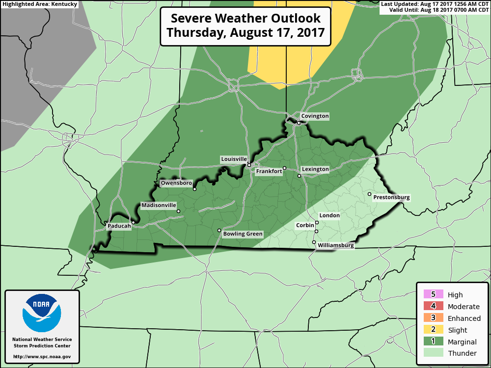
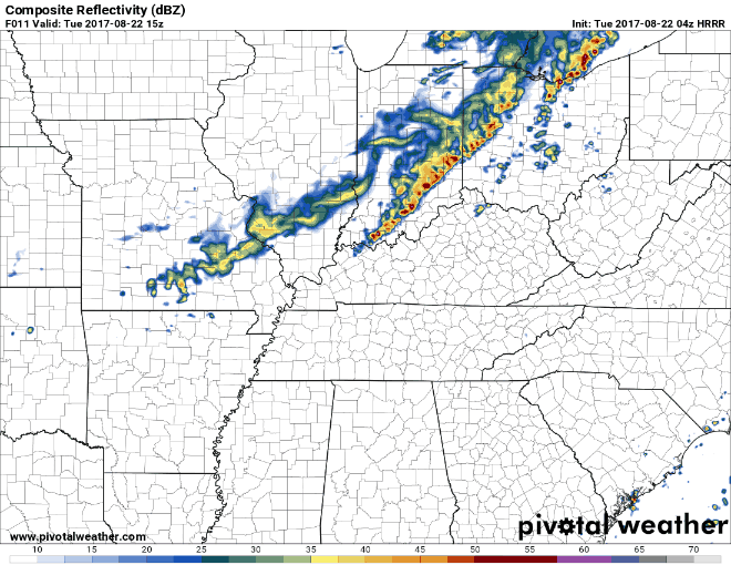
Update: The Storm Prediction Center has expanded the Slight Risk Area to now include parts of southern Ohio and northern Kentucky. The tornado and wind damage probabilities have been increased because of the possibility of rotating storms. Supercell storms are possible that could produce a couple of tornadic storms, widely scattered damaging winds and marginally severe hail. The timing is still after 2 pm EDT. Mainly between 2-9 pm EDT.
-
1. John Kennedy Assassination 1963 I was 5 years old and this happened to be the first time I got cross the street and go to the corner store while my mother watched me. I didn't know what was going on when she came running to get me and rushed back to our apartment. 2. Robert Kennedy Assassination 1968 Remember listening to the accounts and his funeral on the radio in school 3. Rev. Dr. Martin Luther King Assassination 1968 My memory of this is my mother saying,"They finally got him." 4. Apollo 1 fire that killed 3 astronauts. 5. Man walking on the moon 1969 6. Apollo 13 explosion
-
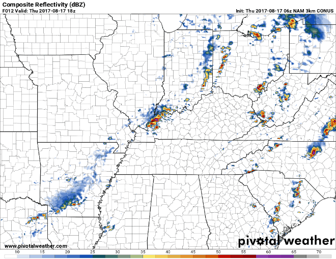
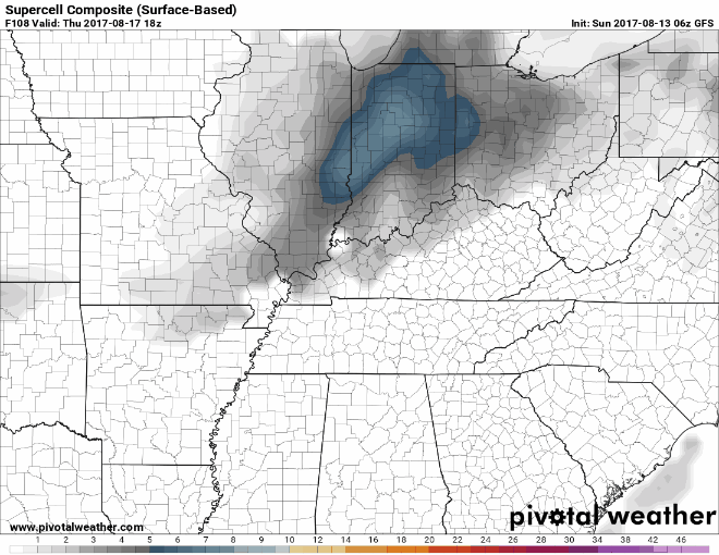
Thursday morning update: Some may see some strong to severe storms this afternoon. These look to be multicellular in nature and the stronger storms could produce strong to locally severe damaging wind gusts. The timing is mainly after 2 pm EDT. The Storm Prediction Center has most of Kentucky in a Marginal Risk Area for today.
-
This is the latest GFS model for predicted cloud cover centered around 2 pm EDT on Monday afternoon. Chances of seeing the total eclipse not looking good at the moment for western Kentucky and southern Illinois.
-
20-40% cloud cover in the Cookeville area is possible.
-
This mornings GFS is showing Missouri with varying degrees of cloud cover. Some areas have 25 to 44% cloud cover. As of this morning it's not looking good to see the total eclipse in southern Illinois, western Kentucky or parts of western Missouri. The GFS is also now showing 99% cloud cover in western Kentucky and parts of southern Illinois.
-
Here are a couple of maps showing the cloud cover and precipitation map. For now, there seems to be a chance that some in WKY may not have a good view of the eclipse. Both of these maps are centered around 2 pm EDT on Monday. They also show the path of the eclipse. Cloud cover Precipitation type map
-
For now, it looks like you should be ok.
-
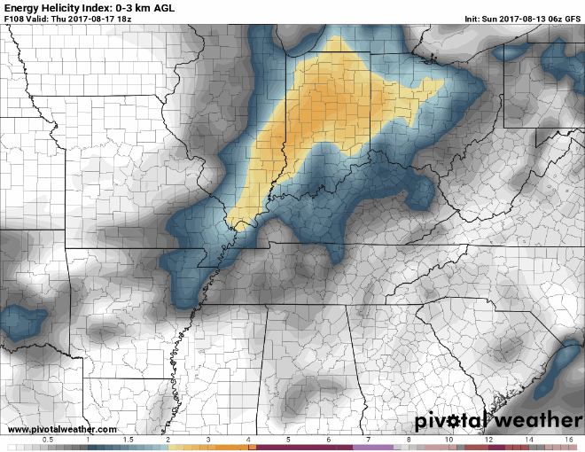
Thunderstorms, some which could become severe, are expected on Thursday. These look to be more multi-cell in nature. Some isolated hail and damaging winds will be possible.
-
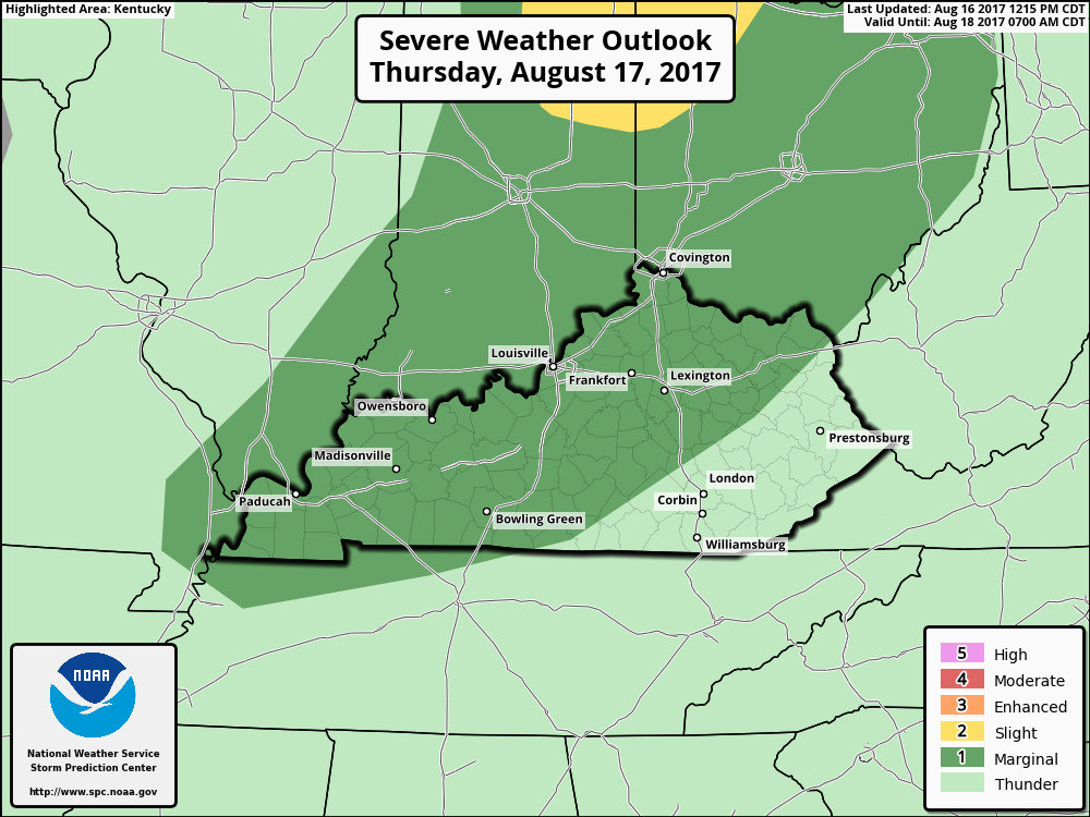
Looks like our next shot at a severe weather occurrence could come on Thursday. Strong to severe storms look possible at this time. I will post updates as we get closer.
-
.thumb.jpg.dc448957daf4ddf2823660190e844abb.jpg)
BGP Fantasy Football League 2017 – National Conference Draft
nWo replied to Godot's topic in Fantasy Sports / Gaming
I just happened to be at lunch and was wondering when the draft started. Then I got the email!! Time to win trophy #2!! :thumb: -
Tropical Storm Emily Local Statement Special Advisory Number 2 National Weather Service Tampa Bay Ruskin FL AL062017 858 AM EDT Mon Jul 31 2017 This product covers West Central and Southwest Florida **TROPICAL STORM EMILY NEARING TAMPA BAY** NEW INFORMATION --------------- * CHANGES TO WATCHES AND WARNINGS: - The Tropical Storm Watch has been upgraded to a Tropical Storm Warning for Coastal Hillsborough, Coastal Manatee, Coastal Sarasota, and Pinellas - A Tropical Storm Warning has been issued for Coastal Charlotte and Coastal Lee * CURRENT WATCHES AND WARNINGS: - A Tropical Storm Warning is in effect for Coastal Charlotte, Coastal Hillsborough, Coastal Lee, Coastal Manatee, Coastal Sarasota, and Pinellas * STORM INFORMATION: - About 30 miles west-northwest of Mouth of Tampa Bay FL or about 50 miles west-northwest of Sarasota FL - 27.7N 83.2W - Storm Intensity 45 mph - Movement East or 95 degrees at 8 mph SITUATION OVERVIEW ------------------ Tropical Storm Emily developed early this morning just offshore of Tampa Bay. It is moving toward the coast and will make landfall later today. The potential for flooding rain remains the greatest threat across the area from Emily. POTENTIAL IMPACTS ----------------- * FLOODING RAIN: Protect against locally hazardous rainfall flooding having possible limited impacts across West Central and Southwest Florida. Potential impacts include: - Localized rainfall flooding may prompt a few evacuations. - Rivers and tributaries may quickly rise with swifter currents. Small streams, creeks, canals, and ditches may become swollen and overflow in spots. - Flood waters can enter a few structures, especially in usually vulnerable spots. A few places where rapid ponding of water occurs at underpasses, low-lying spots, and poor drainage areas. Several storm drains and retention ponds become near-full and begin to overflow. Some brief road and bridge closures. * WIND: Protect against hazardous wind having possible limited impacts across the greater Tampa Bay Area extending south towards southwest Florida. Potential impacts in this area include: - Damage to porches, awnings, carports, sheds, and unanchored mobile homes. Unsecured lightweight objects blown about. - Many large tree limbs broken off. A few trees snapped or uprooted, but with greater numbers in places where trees are shallow rooted. Some fences and roadway signs blown over. - A few roads impassable from debris, particularly within urban or heavily wooded places. Hazardous driving conditions on bridges and other elevated roadways. - Scattered power and communications outages. Elsewhere across West Central Florida, little to no impact is anticipated. * TORNADOES: Protect against a tornado event having possible limited impacts across the greater Tampa Bay Area extending south towards southwest Florida. Potential impacts include: - The occurrence of isolated tornadoes can hinder the execution of emergency plans during tropical events. - A few places may experience tornado damage, along with power and communications disruptions. - Locations could realize roofs peeled off buildings, chimneys toppled, mobile homes pushed off foundations or overturned, large tree tops and branches snapped off, shallow-rooted trees knocked over, moving vehicles blown off roads, and small boats pulled from moorings. Elsewhere across West Central Florida, little to no impact is anticipated.


.gif.b73fdc6ef92654471feaef2e0417dfe0.gif)


.jpg.f7a93b855d2a913d96d9f9f7929d054c.jpg)
.jpg.9adf427a0781c19c9c0aaf4e650e96cd.jpg)


.jpg.a35c2c76b42c7ddd535c2c30f285cd44.jpg)

.png.8e5d43546e0000ecd51a97f531eb9df4.png)

.png.f2bcebcd10012842bb61050d61b68bc8.png)