.png.ffa34568722b20f38e3c3ecfcb9a2cd2.png)

.jpg.dff87640c6ed93f4bdf8eebdf96f5dec.jpg)
nWo
-
Posts
25,628 -
Joined
-
Last visited
-
Days Won
5
Everything posted by nWo
-
As for now the heaviest rain this afternoon looks to be from NKY to just south of Lexington. 1 hour rain fall totals of .5 to 1 inch per hour around 2 pm EDT. After you get south of Richmond you should just see spotty showers.
-
The Storm Prediction Center has a small portion of Kentucky in a Slight Risk Area for strong to severe storms. This is mainly in the London, Corbin and Williamsburg area. The center of the remnant of Harvey is forecast to reach southern Kentucky later this afternoon. Severe storms may be possible with damaging winds and hail as the main threats. A tornado or two also will be possible.

-
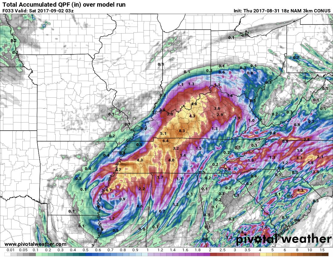
The NAM 3km model is showing 3.2 inches through 11 am EDT Saturday morning. The other NAM is showing upwards to 4 inches.
-
Thursday evening update: Those along I-65, especially in the Bowling Green area, should be preparing for significant flooding. The latest models are showing 5-8" of rain starting later tonight into Friday night. Bowling Green is looking at around upwards to around 8" Along I-75 look for 1-3" for in parts of southern and eastern Kentucky. For those from around the I-64 corridor northward look for 1-4" of rain. Winds anywhere from 15-25 mph with gusts between 30-40 especially in the areas with the heaviest rainfall. Those who live along rivers, streams or areas prone to flooding should be preparing right now.
-
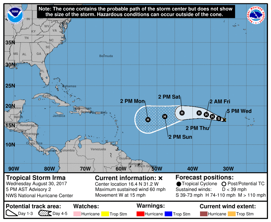
Just took a quick glance at the GFS to check on the path of Irma. If it turns as the GFS is showing right now we are a little more than a week away from any landfall. Those from Florida, Georgia, South Carolina and North Carolina should start paying attention to this storm. The GFS is showing landfall around North Carolina. As we are a little more than a week away this track can and probably will change so I'll post updates as we get closer. Right now the GFS is showing possible 5-7" rain fall totals for those in its path.
-
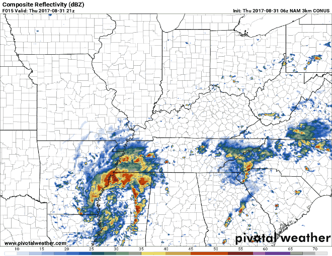
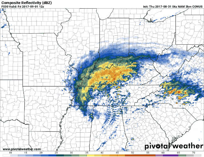
Thursday morning update: It appears that the precipitation should start to reach Kentucky around 5 pm EDT. The heaviest rain accumulation will occur over night Thursday and during the day on Friday. The largest accumulations look to be west of I-65 with 5-7" possible. East of I-65 looks to get 1-3". Some will see winds from around 30-40 mph. These totals will cause significant river flooding. The Storm Prediction Center has parts of eastern Kentucky in a Marginal Risk Area for strong to severe storms on Friday. Extreme southeast Kentucky is in a Slight Risk Area for these possible storms. I will update later today. Here are some maps and simulated radars that show where and when the rain will fall. 5 pm Thursday to 5 am EDT Friday morning 8 am to 5 pm EDT Friday 8 pm Friday to 8 am EDT Saturday
-
Should be. Looks like Friday will be the worst day.
-
Plus there is now another disturbance that bears watching in the Gulf.
-
-
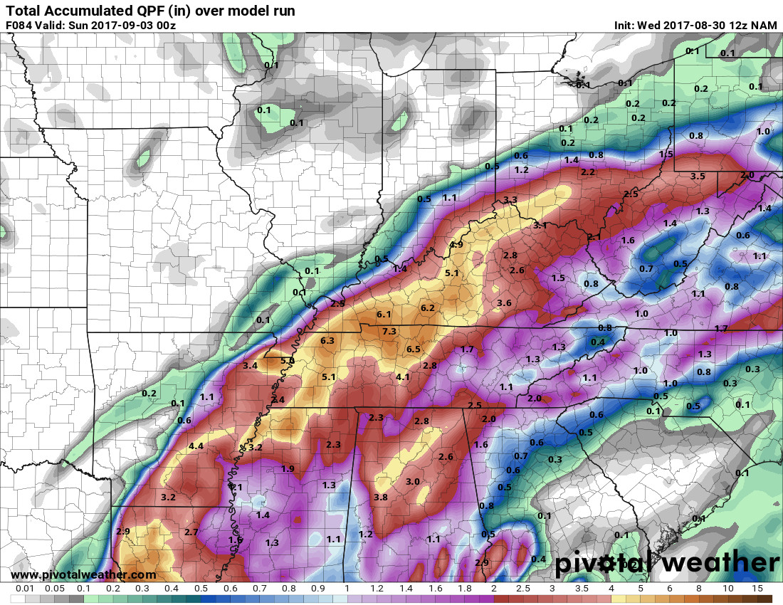
Should start getting a good read on the possible rain accumulations in the morning. Hopefully, the totals will go back down. The GFS is now showing some parts of Kentucky mainly west of I-65 now maybe getting 7-8" of rain.
-
Temps in the mid 70s looks like most of the rain will be done by Sunday.
-
Thanks! :thumb: I've been watching it. Wasn't going to post anything for now because it was no threat to any land.
-
For now, it looks like the chance for strong to severe storms will be confined mainly along the Kentucky/Tennessee border.
-
Flood Watch National Weather Service Jackson KY 330 PM EDT Wed Aug 30 2017 ...Remnants of Tropical Cyclone Harvey to Bring Heavy Rains... .The remains of tropical system Harvey will lift through the western Tennessee Valley and into Kentucky to close out the work week. As it does so, it will spread showers and a few thunderstorms into the area starting on Thursday and continuing into Saturday morning. The heaviest rains are expected for eastern Kentucky from Thursday night through Friday night. Total rainfall amounts from this event are expected to range from around an inch in the far eastern parts of the state to near 3 inches along the Bluegrass region and generally west of Interstate 75. Localized amounts could reach 4 inches for a few spots closer to central and northern Kentucky. This rain will result in a thorough soaking of the region and the potential for local high water issues. KYZ044-050>052-058>060-068-069-079-080-083-104-106-108-111-114- 310330- /O.NEW.KJKL.FF.A.0010.170901T0000Z-170902T0600Z/ /00000.0.ER.000000T0000Z.000000T0000Z.000000T0000Z.OO/ Fleming-Montgomery-Bath-Rowan-Estill-Powell-Menifee-Rockcastle- Jackson-Pulaski-Laurel-Wayne-Elliott-Morgan-Wolfe-Lee-Owsley- Including the cities of Flemingsburg, Camargo, Jeffersonville, Mount Sterling, Owingsville, Morehead, Irvine, Ravenna, Clay City, Stanton, Frenchburg, Brodhead, Mount Vernon, McKee, Annville, Burnside, Somerset, London, Monticello, Sandy Hook, West Liberty, Campton, Beattyville, and Booneville 330 PM EDT Wed Aug 30 2017 ...FLASH FLOOD WATCH IN EFFECT FROM THURSDAY EVENING THROUGH LATE FRIDAY NIGHT... The National Weather Service in Jackson has issued a * Flash Flood Watch for portions of east central Kentucky, south central Kentucky, and southeast Kentucky, including the following areas, in east central Kentucky, Bath, Elliott, Estill, Fleming, Menifee, Montgomery, Powell, and Rowan. In south central Kentucky, Laurel, Pulaski, Rockcastle, and Wayne. In southeast Kentucky, Jackson, Lee, Morgan, Owsley, and Wolfe. * From Thursday evening through late Friday night. * Heavy rains of 1 to 3 inches are expected from Thursday through Saturday with localized amounts of 4 inches possible. * Flash flooding of creeks and streams will be possible, especially in areas that see repeated rounds of heavy rain. PRECAUTIONARY/PREPAREDNESS ACTIONS... A Flash Flood Watch means that conditions may develop that lead to flash flooding. Flash flooding is a VERY DANGEROUS SITUATION. You should monitor later forecasts and be prepared to take action should Flash Flood Warnings be issued.
-
Flood Watch National Weather Service Wilmington OH 402 PM EDT Wed Aug 30 2017 INZ075-080-KYZ089>099-311100- /O.NEW.KILN.FF.A.0010.170901T0300Z-170902T0900Z/ /00000.0.ER.000000T0000Z.000000T0000Z.000000T0000Z.OO/ Ohio-Switzerland-Carroll-Gallatin-Boone-Kenton-Campbell-Owen- Grant-Pendleton-Bracken-Robertson-Mason- Including the cities of Rising Sun, Vevay, Carrollton, Warsaw, Florence, Burlington, Oakbrook, Covington, Erlanger, Independence, Newport, Alexandria, Owenton, Williamstown, Crittenden, Dry Ridge, Falmouth, Butler, Augusta, Brooksville, Mount Olivet, and Maysville 402 PM EDT Wed Aug 30 2017 ...FLASH FLOOD WATCH IN EFFECT FROM THURSDAY EVENING THROUGH LATE FRIDAY NIGHT... The National Weather Service in Wilmington has issued a * Flash Flood Watch for portions of Southeast Indiana and Northern Kentucky, including the following areas, in Southeast Indiana, Ohio and Switzerland. In Northern Kentucky, Boone, Bracken, Campbell, Carroll, Gallatin, Grant, Kenton, Mason, Owen, Pendleton, and Robertson. * From Thursday evening through late Friday night. * As the remnants of Harvey approach the area late Thursday evening into early Friday morning showers will overspread the area. Rainfall rates will increase Friday morning into early Friday afternoon and then taper off late Friday night. A band of 2 to 4 inches with locally higher amounts will be possible through Friday night. PRECAUTIONARY/PREPAREDNESS ACTIONS... People in the watch area should keep an eye on the weather and be prepared for immediate action should heavy rains and flooding occur or a Flash Flood Warning be issued. Avoid low-lying areas, and be careful when approaching highway dips and underpasses.
-
Flood Watch National Weather Service Paducah KY 331 PM CDT Wed Aug 30 2017 ...Widespread heavy rainfall is expected Thursday night into Friday... .The remnants of tropical cyclone Harvey will move northeast and across west Tennessee Thursday night, eventually reaching eastern Kentucky by Friday evening. As the system passes close to the area, widespread heavy rainfall is likely across much of western Kentucky Thursday night into early Friday. Some areas will likely see more than 6 inches of rainfall. This is most likely just north of the Tennessee state line, from around the Murray area east to Greenville, Hopkinsville and Elkton. Any slight shift in the track of the system will have an impact on how far northwest the heaviest rains will occur. KYZ001>003-005>013-015>017-019>022-310930- /O.NEW.KPAH.FF.A.0007.170901T0000Z-170902T0000Z/ /00000.0.ER.000000T0000Z.000000T0000Z.000000T0000Z.OO/ Fulton-Hickman-Carlisle-McCracken-Graves-Livingston-Marshall- Calloway-Crittenden-Lyon-Trigg-Caldwell-Webster-Hopkins-Christian- Daviess-McLean-Muhlenberg-Todd- Including the cities of Hickman, Clinton, Bardwell, Paducah, Mayfield, Smithland, Benton, Murray, Marion, Eddyville, Cadiz, Princeton, Dixon, Madisonville, Hopkinsville, Owensboro, Calhoun, Greenville, and Elkton 331 PM CDT Wed Aug 30 2017 ...FLASH FLOOD WATCH IN EFFECT FROM THURSDAY EVENING THROUGH FRIDAY EVENING... The National Weather Service in Paducah has issued a * Flash Flood Watch for a portion of western Kentucky, including the following areas, Caldwell, Calloway, Carlisle, Christian, Crittenden, Daviess, Fulton, Graves, Hickman, Hopkins, Livingston, Lyon, Marshall, McCracken, McLean, Muhlenberg, Todd, Trigg, and Webster. * From Thursday evening through Friday evening. * Widespread heavy rainfall is forecast across western Kentucky. Rainfall amounts will range from 3 to 6 inches. The highest amounts are forecast just north of the Tennessee, Kentucky state line, including areas from Murray, to Greenville, Hopkinsville and Elkton. Higher amounts cannot be ruled out in this area. * Sharp rises in creeks and small streams will likely occur. Low lying areas may quickly become flooded. Low lying areas in both urban and rural settings will be most prone to flooding. Travelers should be aware of these threat areas and avoid them if at all possible. PRECAUTIONARY/PREPAREDNESS ACTIONS... A Flash Flood Watch means that conditions may develop that lead to flash flooding. Flash flooding is a very dangerous situation. You should monitor later forecasts and be prepared to take action should Flash Flood Warnings be issued.
-
...FLASH FLOOD WATCH IN EFFECT FROM THURSDAY EVENING THROUGH LATE FRIDAY NIGHT... The National Weather Service in Louisville has issued a * Flash Flood Watch for central Kentucky and extreme southern Indiana. * From Thursday evening through late Friday night * Moisture associated with Tropical Storm Harvey will bring heavy rain to the region. * Local flooding will be possible, especially late Thursday night into Friday morning. PRECAUTIONARY/PREPAREDNESS ACTIONS... A Flash Flood Watch means that conditions may develop that lead to flash flooding. Flash flooding is a very dangerous situation. You should monitor later forecasts and be prepared to take action should Flash Flood Warnings be issued.
-
This is through Saturday night at 8 pm EDT.
-
This is going to very quick. Most of Kentucky will feel the effects of the remnants of Hurricane Harvey this weekend. Some could see upwards to 6" of rain by the end of the weekend. I'll post a more detailed update later today.
-
Tropical Storm Harvey is predicted to move back off shore Monday evening regain some strength then move back on shore in Texas Tuesday morning. For now, this system is not predicted to move away from Texas until the end of the week. Some models are now showing upwards to 50" of rain for parts of Texas by the time this storm moves on. As of now, Harvey is actually feeding off of its self. That is what is causing the tremendous rainfall total this weekend.
-
If the political thread is any indication. I would be against it.
-
As expected the possible rain accumulations have gone up for the New Orleans area. The GFS is now showing a possible 5-8" of rain for New Orleans by Wednesday evening. There is a possibility of these totals going up.
-
You can expect 2-4" of rain by Tuesday afternoon. These totals could go up. I also expect a lot of flight cancellations.
-
This is what the GFS shows through next Wednesday night.
-
As of now the storm looks to still be over Texas by next Wednesday.
.thumb.jpg.dc448957daf4ddf2823660190e844abb.jpg)