.png.ffa34568722b20f38e3c3ecfcb9a2cd2.png)

.jpg.dff87640c6ed93f4bdf8eebdf96f5dec.jpg)
nWo
-
Posts
25,628 -
Joined
-
Last visited
-
Days Won
5
Everything posted by nWo
-
Thursday morning update: Really no changes to the forecast. The only thing I will change is that some parts of Kentucky may now receive around 3" of rain. This looks to be parts of western and eastern Kentucky. A small area around Lexington also. These storms look to develop throughout the day with the strongest storms being this afternoon. A marginal damaging wind threat looks to be the main thing to look for.

-
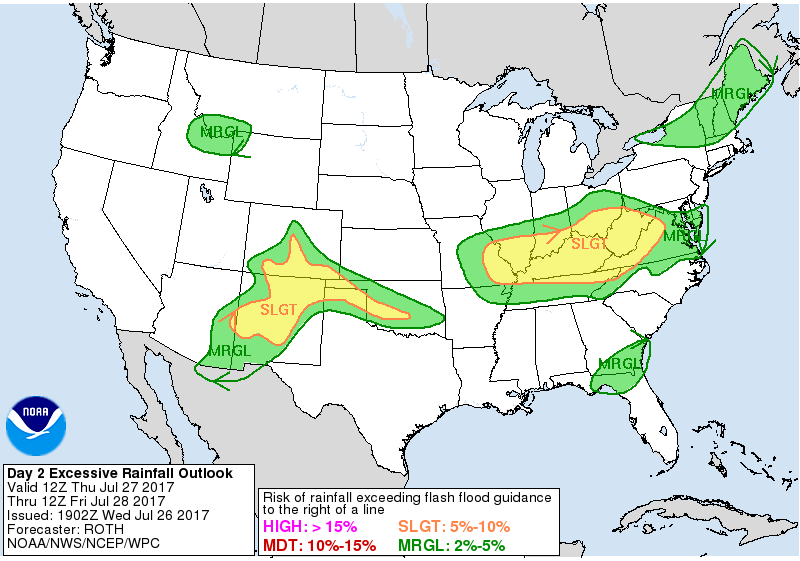
Wednesday evening update: The severe threat has diminished some but scattered thunderstorms will develop on Thursday. A few storms may produce gusty winds. There maybe a few damaging downbursts possible. The Storm Prediction Center has Kentucky now in a Marginal Risk Area for strong to severe storms on Thursday. The Weather Prediction Center has all of Kentucky southern Indiana and southern Ohio in a Slight Risk Area for rainfall exceeding flash flood criteria. As I stated earlier this morning some parts of Kentucky could see upwards to 2" of rain by early Friday morning.
-
Wednesday morning update: As expected this morning the Storm Prediction Center has expanded the Slight Risk Area for Thursday. As of now, the entire state of Kentucky is included. Along with parts of southern Indiana and Ohio. Strong/locally severe storms are forecast to spread across the region Thursday afternoon and evening. The risk may also continue into the overnight hours. Some could see from 1-2" of rain under the stronger storms. Update later today.
-
The Storm Prediction Center has most of Kentucky north and east of a line from just south of Louisville southeastward just north of London. This is for Thursday afternoon. While there is still some uncertainty this could be extended into the evening hours. Also if the modeling data holds, the Slight Risk Area might be extended back westward some. I will update in the morning.
-
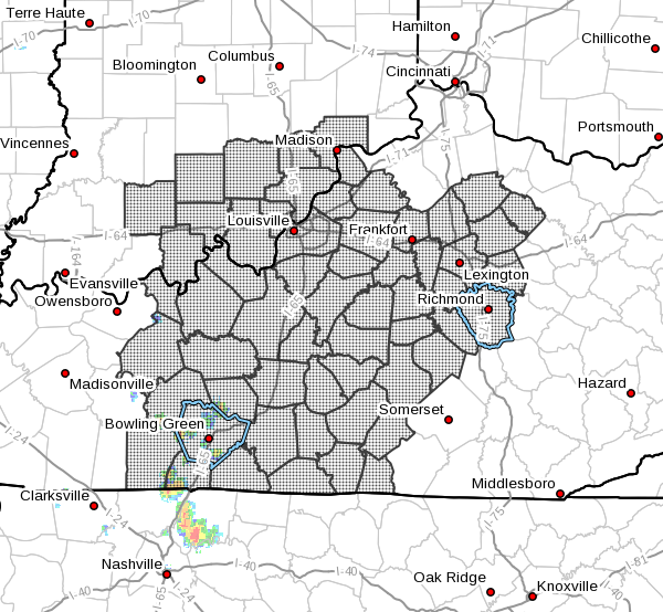
Even though some have seen showers/storms this morning the possibility of strong to severe storms to fire back up exists for later today. Portions of Kentucky are in a Slight Risk Area while the remainder of the state is in a Marginal Risk Area. These storms will be mainly multicell storms but a few supercell storms are possible. Isolated damaging winds and hail will be the primary threats. For now it looks like the storms will start to fire up around the 4 pm EDT time period.
-
Thunderstorm outlook 8 pm till midnight EDT Midnight till 3 am EDT
-
Just issued while I was typing my first post. Parts of central and western Ohio are being monitored for the possibility of the issuance of a severe weather watch.
-
The Storm Prediction Center has expanded the Slight Risk area west. Parts of Kentucky are now included in this area. This is for those mainly north of I-64. South of I-64 could see widely scattered strong to severe storms. The primary risks are damaging winds and a secondary risk of severe hail. For now the timing looks to be mainly after 8 pm EDT.
-
Saturday Morning update: URGENT - WEATHER MESSAGE National Weather Service Louisville KY 334 AM EDT Sat Jul 22 2017 ...Oppressive Heat and Humidity Today... .High temperatures today will reach the mid to upper 90s and combined with high humidity, oppressive heat indices in the 105 to 110 range are expected. INZ076>079-083-084-089>092-KYZ023>034-038-045-053-061>063-070>074- 221545- /O.CON.KLMK.HT.Y.0001.000000T0000Z-170723T0000Z/ Orange-Washington-Scott-Jefferson-Dubois-Crawford-Perry-Harrison- Floyd-Clark-Hancock-Breckinridge-Meade-Ohio-Grayson-Hardin- Bullitt-Oldham-Trimble-Henry-Shelby-Spencer-Nelson-Larue-Butler- Edmonson-Hart-Logan-Warren-Simpson-Allen-Barren- Including the cities of Paoli, Salem, Scottsburg, Madison, Jasper, English, Tell City, Corydon, New Albany, Jeffersonville, Lewisport, Hawesville, Hardinsburg, Brandenburg, Hartford, Leitchfield, Elizabethtown, Shepherdsville, Louisville, La Grange, Bedford, Milton, New Castle, Shelbyville, Taylorsville, Bardstown, Hodgenville, Morgantown, Brownsville, Horse Cave, Russellville, Bowling Green, Franklin, Providence, Scottsville, and Glasgow 334 AM EDT Sat Jul 22 2017 /234 AM CDT Sat Jul 22 2017/ ...HEAT ADVISORY REMAINS IN EFFECT UNTIL 8 PM EDT /7 PM CDT/ THIS EVENING... * HEAT INDEX VALUES...Peak heat index values 105 to 110. * IMPACTS...The combination of hot temperatures and high humidity will lead to an increased risk of heat related stress and illnesses. The very young, the elderly, those without air conditioning, and those participating in strenuous outdoor activities will be the most susceptible. PRECAUTIONARY/PREPAREDNESS ACTIONS... Take extra precautions...if you work or spend time outside. When possible...reschedule strenuous activities to early morning or evening. Know the signs and symptoms of heat exhaustion and heat stroke. Wear light weight and loose fitting clothing when possible and drink plenty of water.
-
-
-
URGENT - WEATHER MESSAGE National Weather Service Paducah KY 324 AM CDT Sat Jul 22 2017 ...Dangerous levels of heat and humidity to continue through the weekend... .A large upper level high will be slow to break down through the weekend, resulting in persistent heat and humidity. INZ081-082-085>088-KYZ006>022-222045- /O.UPG.KPAH.HT.Y.0001.000000T0000Z-170724T0000Z/ /O.EXA.KPAH.EH.W.0001.000000T0000Z-170724T0000Z/ Gibson-Pike-Posey-Vanderburgh-Warrick-Spencer-Graves-Livingston- Marshall-Calloway-Crittenden-Lyon-Trigg-Caldwell-Union KY-Webster- Hopkins-Christian-Henderson-Daviess-McLean-Muhlenberg-Todd- Including the cities of Fort Branch, Petersburg, Poseyville, Evansville, Boonville, Rockport, Mayfield, Smithland, Benton, Murray, Marion, Eddyville, Cadiz, Princeton, Morganfield, Dixon, Madisonville, Hopkinsville, Henderson, Owensboro, Calhoun, Greenville, and Elkton 324 AM CDT Sat Jul 22 2017 ...EXCESSIVE HEAT WARNING IN EFFECT UNTIL 7 PM CDT SUNDAY... The National Weather Service in Paducah has issued an Excessive Heat Warning, which is in effect until 7 PM CDT Sunday. The Heat Advisory is no longer in effect. * TIMING...through Sunday evening. * HEAT INDEX VALUES...Peak heat indices will be around 110 degrees this afternoon most areas. Some locales may reach as high as 115. On Sunday, peak indices will range from 100 to 110 degrees.A slight chance of thunderstorms and some added cloud cover may hold heat index values down in some areas Sunday. * IMPACTS...The combination of the persistent hot temperatures and high humidity results in a high risk of heat-related illness. The very young, the elderly, those without air conditioning, and those participating in strenuous outdoor activities will be the most susceptible. Also, car interiors will reach lethal temperatures in a matter of minutes. PRECAUTIONARY/PREPAREDNESS ACTIONS... Take extra precautions...if you work or spend time outside. When possible...reschedule strenuous activities to early morning or evening. Know the signs and symptoms of heat exhaustion and heat stroke. Wear light weight and loose fitting clothing when possible and drink plenty of water. An Excessive Heat Warning means that a prolonged period of dangerously hot temperatures will occur. The combination of hot temperatures and high humidity will combine to create a dangerous situation in which heat illnesses are likely. Drink plenty of fluids...stay in an air-conditioned room...stay out of the sun... and check up on relatives and neighbors.
-
URGENT - WEATHER MESSAGE National Weather Service Louisville KY 345 AM EDT Fri Jul 21 2017 ...Very Hot and Humid Through Saturday... .Temperatures reaching the mid 90s combined with oppressive humidity will create afternoon heat indices in the 105 to 108 range today and Saturday. INZ076>079-083-084-089>092-KYZ023>034-038-045-053-061>063-070>074- 212200- /O.CON.KLMK.HT.Y.0001.170721T1600Z-170723T0000Z/ Orange-Washington-Scott-Jefferson-Dubois-Crawford-Perry-Harrison- Floyd-Clark-Hancock-Breckinridge-Meade-Ohio-Grayson-Hardin- Bullitt-Oldham-Trimble-Henry-Shelby-Spencer-Nelson-Larue-Butler- Edmonson-Hart-Logan-Warren-Simpson-Allen-Barren- Including the cities of Paoli, Salem, Scottsburg, Madison, Jasper, English, Tell City, Corydon, New Albany, Jeffersonville, Lewisport, Hawesville, Hardinsburg, Brandenburg, Hartford, Leitchfield, Elizabethtown, Shepherdsville, Louisville, La Grange, Bedford, Milton, New Castle, Shelbyville, Taylorsville, Bardstown, Hodgenville, Morgantown, Brownsville, Horse Cave, Russellville, Bowling Green, Franklin, Providence, Scottsville, and Glasgow 345 AM EDT Fri Jul 21 2017 /245 AM CDT Fri Jul 21 2017/ ...HEAT ADVISORY REMAINS IN EFFECT FROM NOON EDT /11 AM CDT/ TODAY TO 8 PM EDT /7 PM CDT/ SATURDAY... * HEAT INDEX VALUES...Peak heat index values 105 to 109 each afternoon. * IMPACTS...The combination of hot temperatures and high humidity will lead to an increased risk of heat related stress and illnesses. The very young, the elderly, those without air conditioning, and those participating in strenuous outdoor activities will be the most susceptible. PRECAUTIONARY/PREPAREDNESS ACTIONS... Take extra precautions...if you work or spend time outside. When possible...reschedule strenuous activities to early morning or evening. Know the signs and symptoms of heat exhaustion and heat stroke. Wear light weight and loose fitting clothing when possible and drink plenty of water.
-
The Storm Prediction Center has some parts of Kentucky in a Marginal Risk Area for some possible storms today. These look to be isolated and could put down some heavy rain and could cause some flash flooding. The main threats look to be damaging wind and hail.
-
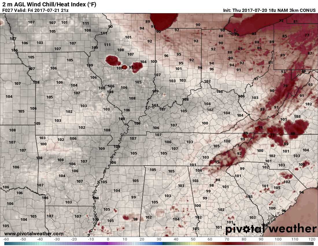
Thursday evening update: Franklin-Scott-Harrison-Anderson-Woodford-Fayette-Bourbon- Nicholas-Washington-Mercer-Jessamine-Clark-Marion-Boyle-Garrard- Madison-Green-Taylor-Casey-Lincoln-Monroe-Metcalfe-Adair-Russell- Cumberland-Clinton- Including the cities of Frankfort, Georgetown, Cynthiana, Lawrenceburg, Versailles, Lexington, Paris, Carlisle, Springfield, Harrodsburg, Nicholasville, Winchester, Lebanon, Danville, Lancaster, Richmond, Greensburg, Campbellsville, Liberty, Stanford, Tompkinsville, Edmonton, Columbia, Jamestown, Burkesville, and Albany 403 PM EDT Thu Jul 20 2017 /303 PM CDT Thu Jul 20 2017/ ...Hot and Humid Friday... High temperatures will reach the lower 90s Friday and combined with the high humidity, maximum heat indices in the afternoon will reach the low 100s. Those planning outdoor activities should take frequent breaks in the shade, drink plenty of water, and limit strenuous activities during the early and mid afternoon hours.
-
Maps for 5 pm EDT on Friday Air temps Heat Index
-
The Heat Advisory area has been expanded. URGENT - WEATHER MESSAGE National Weather Service Louisville KY 309 PM EDT Thu Jul 20 2017 ...Very Hot and Humid Through Saturday... .Afternoon temperatures in the 90s combined with high humidity will create heat indices in the 105 to 108 range Friday and Saturday afternoons. INZ076>078-083-084-089>092-KYZ023>031-034-038-045-053-061>063- 070>074-211000- /O.EXT.KLMK.HT.Y.0001.170721T1600Z-170723T0000Z/ Orange-Washington-Scott-Dubois-Crawford-Perry-Harrison-Floyd- Clark-Hancock-Breckinridge-Meade-Ohio-Grayson-Hardin-Bullitt- Jefferson-Oldham-Shelby-Spencer-Nelson-Larue-Butler-Edmonson-Hart- Logan-Warren-Simpson-Allen-Barren- Including the cities of Paoli, Salem, Scottsburg, Jasper, English, Tell City, Corydon, New Albany, Jeffersonville, Lewisport, Hawesville, Hardinsburg, Brandenburg, Hartford, Leitchfield, Elizabethtown, Shepherdsville, Louisville, La Grange, Shelbyville, Taylorsville, Bardstown, Hodgenville, Morgantown, Brownsville, Horse Cave, Russellville, Bowling Green, Franklin, Providence, Scottsville, and Glasgow 309 PM EDT Thu Jul 20 2017 /209 PM CDT Thu Jul 20 2017/ ...HEAT ADVISORY NOW IN EFFECT FROM NOON EDT /11 AM CDT/ FRIDAY TO 8 PM EDT /7 PM CDT/ SATURDAY... * HEAT INDEX VALUES...Peak heat index values 105 to 108 Friday and Saturday afternoons. * IMPACTS...The combination of hot temperatures and high humidity will lead to an increased risk of heat related stress and illnesses. The very young, the elderly, those without air conditioning, and those participating in strenuous outdoor activities will be the most susceptible. PRECAUTIONARY/PREPAREDNESS ACTIONS... Take extra precautions...if you work or spend time outside. When possible...reschedule strenuous activities to early morning or evening. Know the signs and symptoms of heat exhaustion and heat stroke. Wear light weight and loose fitting clothing when possible and drink plenty of water.
-
Thursday morning update: URGENT - WEATHER MESSAGE National Weather Service Paducah KY 301 AM CDT Thu Jul 20 2017 ...Dangerous heat and humidity to continue through Sunday... .A large upper level high will produce a dome of heat and humidity across the region through Sunday. The combination of the heat and humidity will produce maximum heat index values over from 103 to 107 degrees each day from the late morning to late afternoon hours, with peak heat index values pushing 105 degrees or slightly higher some areas. Actual high temperatures will be in the mid 90s, and in a few places upper 90s. ILZ075>078-080>094-INZ081-082-085>088-KYZ001>022-MOZ076-086-087- 100-107>112-114-201615- /O.CON.KPAH.HT.Y.0001.000000T0000Z-170724T0000Z/ Jefferson-Wayne IL-Edwards-Wabash-Perry IL-Franklin-Hamilton- White-Jackson-Williamson-Saline-Gallatin-Union-Johnson-Pope- Hardin-Alexander-Pulaski-Massac-Gibson-Pike-Posey-Vanderburgh- Warrick-Spencer-Fulton-Hickman-Carlisle-Ballard-McCracken-Graves- Livingston-Marshall-Calloway-Crittenden-Lyon-Trigg-Caldwell- Union KY-Webster-Hopkins-Christian-Henderson-Daviess-McLean- Muhlenberg-Todd-Perry MO-Bollinger-Cape Girardeau-Wayne MO-Carter- Ripley-Butler-Stoddard-Scott-Mississippi-New Madrid- Including the cities of Mount Vernon, Fairfield, Albion, Mount Carmel, Pinckneyville, West Frankfort, McLeansboro, Carmi, Carbondale, Murphysboro, Herrin, Harrisburg, Shawneetown, Jonesboro, Vienna, Golconda, Elizabethtown, Cairo, Mound City, Metropolis, Fort Branch, Petersburg, Poseyville, Evansville, Boonville, Rockport, Hickman, Clinton, Bardwell, Wickliffe, Paducah, Mayfield, Smithland, Benton, Murray, Marion, Eddyville, Cadiz, Princeton, Morganfield, Dixon, Madisonville, Hopkinsville, Henderson, Owensboro, Calhoun, Greenville, Elkton, Perryville, Marble Hill, Cape Girardeau, Jackson, Piedmont, Van Buren, Doniphan, Poplar Bluff, Bloomfield, Sikeston, Charleston, and New Madrid 301 AM CDT Thu Jul 20 2017 ...HEAT ADVISORY REMAINS IN EFFECT UNTIL 7 PM CDT SUNDAY... * TIMING...Through Sunday evening. * HEAT INDEX VALUES...Peak values will be between 103 and 107 degrees during the mid/late afternoon. In addition, we will likely experience values of 100 degrees or higher for several hours at a time. * IMPACTS...The combination of hot temperatures and high humidity will lead to an increased risk of heat related stress and illness. The very young, the elderly, those without air conditioning, and those participating in strenuous outdoor activities will be the most susceptible. Also, car interiors will reach lethal temperatures in a matter of minutes. Beat the heat, check the back seat! PRECAUTIONARY/PREPAREDNESS ACTIONS... A Heat Advisory means that a period of hot temperatures is expected. The combination of hot temperatures and high humidity will combine to create a situation in which heat illnesses are possible. Drink plenty of fluids...stay in an air-conditioned room...stay out of the sun...and check up on relatives and neighbors.
-
Thursday morning update: 328 AM EDT Thu Jul 20 2017 /228 AM CDT Thu Jul 20 2017/ ...HOT AND HUMID THROUGH SATURDAY... Afternoon temperatures will reach well into the 90s today through Saturday, with heat index values near or above 100 degrees. The hottest day will be Friday, with heat indices possibly exceeding 105 degrees in some locations. The best chance for dangerously hot conditions will be along and west of Interstate 65, and in urban Louisville. Those planning outdoor activities later this week should take frequent breaks in the shade, drink plenty of water, and limit strenuous activities during the early and mid afternoon hours. Monitor later forecasts for updates and possible advisories.
-
Afternoon update. URGENT - WEATHER MESSAGE National Weather Service Paducah KY 255 PM CDT Wed Jul 19 2017 ...Dangerous heat and humidity to continue through Sunday... .A large upper level high will produce a dome of heat and humidity across the region through Sunday. The combination of the heat and humidity will produce maximum heat index values over from 103 to 107 degrees each day from the late morning to late afternoon hours, with peak heat index values pushing 105 degrees or slightly higher some areas. Actual high temperatures will be in the mid 90s, and in a few places upper 90s. ILZ075>078-080>094-INZ081-082-085>088-KYZ001>022-MOZ076-086-087- 100-107>112-114-201000- /O.CON.KPAH.HT.Y.0001.000000T0000Z-170724T0000Z/ Jefferson-Wayne IL-Edwards-Wabash-Perry IL-Franklin-Hamilton- White-Jackson-Williamson-Saline-Gallatin-Union-Johnson-Pope- Hardin-Alexander-Pulaski-Massac-Gibson-Pike-Posey-Vanderburgh- Warrick-Spencer-Fulton-Hickman-Carlisle-Ballard-McCracken-Graves- Livingston-Marshall-Calloway-Crittenden-Lyon-Trigg-Caldwell- Union KY-Webster-Hopkins-Christian-Henderson-Daviess-McLean- Muhlenberg-Todd-Perry MO-Bollinger-Cape Girardeau-Wayne MO-Carter- Ripley-Butler-Stoddard-Scott-Mississippi-New Madrid- Including the cities of Mount Vernon, Fairfield, Albion, Mount Carmel, Pinckneyville, West Frankfort, McLeansboro, Carmi, Carbondale, Murphysboro, Herrin, Harrisburg, Shawneetown, Jonesboro, Vienna, Golconda, Elizabethtown, Cairo, Mound City, Metropolis, Fort Branch, Petersburg, Poseyville, Evansville, Boonville, Rockport, Hickman, Clinton, Bardwell, Wickliffe, Paducah, Mayfield, Smithland, Benton, Murray, Marion, Eddyville, Cadiz, Princeton, Morganfield, Dixon, Madisonville, Hopkinsville, Henderson, Owensboro, Calhoun, Greenville, Elkton, Perryville, Marble Hill, Cape Girardeau, Jackson, Piedmont, Van Buren, Doniphan, Poplar Bluff, Bloomfield, Sikeston, Charleston, and New Madrid 255 PM CDT Wed Jul 19 2017 ...HEAT ADVISORY REMAINS IN EFFECT UNTIL 7 PM CDT SUNDAY... * TIMING...Through Sunday evening. * HEAT INDEX VALUES...Peak values will be between 103 and 107 degrees during the mid/late afternoon. In addition, we will likely experience values of 100 degrees or higher for several hours at a time. * IMPACTS...The combination of hot temperatures and high humidity will lead to an increased risk of heat related stress and illness. The very young, the elderly, those without air conditioning, and those participating in strenuous outdoor activities will be the most susceptible. Also, car interiors will reach lethal temperatures in a matter of minutes. Beat the heat, check the back seat! PRECAUTIONARY/PREPAREDNESS ACTIONS... A Heat Advisory means that a period of hot temperatures is expected. The combination of hot temperatures and high humidity will combine to create a situation in which heat illnesses are possible. Drink plenty of fluids...stay in an air-conditioned room...stay out of the sun...and check up on relatives and neighbors.
-
Afternoon update 347 PM EDT Wed Jul 19 2017 /247 PM CDT Wed Jul 19 2017/ ...HOT AND HUMID THURSDAY THROUGH SATURDAY... Temperatures will reach the mid 90s Thursday through Saturday, with afternoon heat index values near or above 100 degrees. The hottest day will be Friday, with heat indices possibly exceeding 105 degrees in some locations. The best chance for dangerously hot conditions will be along and west of Interstate 65, and in urban Louisville. Those planning outdoor activities later this week should take frequent breaks in the shade, drink plenty of water, and limit strenuous activities during the early and mid afternoon hours. Monitor later forecasts for updates and possible advisories.
-
Radar valid at 455 am EDT, Jul 19th 2017 INZ076>079-083-084-089>092-KYZ023>043-045>049-053>057-061>067- 070>078-081-082-192200- Orange-Washington-Scott-Jefferson-Dubois-Crawford-Perry-Harrison- Floyd-Clark-Hancock-Breckinridge-Meade-Ohio-Grayson-Hardin- Bullitt-Oldham-Trimble-Henry-Shelby-Franklin-Spencer-Anderson- Woodford-Fayette-Bourbon-Nicholas-Nelson-Mercer-Jessamine-Larue- Marion-Boyle-Garrard-Madison-Butler-Edmonson-Hart-Green-Taylor- Casey-Lincoln-Logan-Warren-Simpson-Allen-Barren-Monroe-Metcalfe- Adair-Russell-Cumberland-Clinton- Including the cities of Paoli, Salem, Scottsburg, Madison, Jasper, English, Tell City, Corydon, New Albany, Jeffersonville, Lewisport, Hawesville, Hardinsburg, Brandenburg, Hartford, Leitchfield, Elizabethtown, Shepherdsville, Louisville, La Grange, Bedford, Milton, New Castle, Shelbyville, Frankfort, Georgetown, Cynthiana, Taylorsville, Lawrenceburg, Versailles, Lexington, Paris, Carlisle, Bardstown, Springfield, Harrodsburg, Nicholasville, Winchester, Hodgenville, Lebanon, Danville, Lancaster, Richmond, Morgantown, Brownsville, Horse Cave, Greensburg, Campbellsville, Liberty, Stanford, Russellville, Bowling Green, Franklin, Providence, Scottsville, Glasgow, Tompkinsville, Edmonton, Columbia, Jamestown, Burkesville, and Albany 319 AM EDT Wed Jul 19 2017 /219 AM CDT Wed Jul 19 2017/ ...HOT AND HUMID THURSDAY THROUGH SATURDAY... Temperatures will reach the mid 90s Thursday through Saturday, with afternoon heat index values near or above 100 degrees. The hottest day will be Friday, with heat indices possibly reaching 105 degrees in some locations. The best chance for dangerously hot conditions will be along and west of Interstate 65, and in urban Louisville. Those planning outdoor activities later this week should take frequent breaks in the shade, drink plenty of water, and limit strenuous activities during the early and mid afternoon hours. Monitor later forecasts for updates and possible advisories.
-
URGENT - WEATHER MESSAGE National Weather Service Paducah KY 251 AM CDT Wed Jul 19 2017 ...Dangerous heat and humidity Wednesday through Sunday... .A large upper level high will produce a dome of heat and humidity across the region through Sunday. The combination of the heat and humidity will produce maximum heat index values over 100 degrees each day from the late morning to late afternoon hours, with peak heat index values pushing 105 degrees or slightly higher some areas. Actual high temperatures will be in the mid 90s, and in a few places upper 90s. ILZ075>078-080>094-INZ081-082-085>088-KYZ001>022-MOZ076-086-087- 100-107>112-114-192100- /O.CON.KPAH.HT.Y.0001.170719T1700Z-170724T0000Z/ Jefferson-Wayne IL-Edwards-Wabash-Perry IL-Franklin-Hamilton- White-Jackson-Williamson-Saline-Gallatin-Union-Johnson-Pope- Hardin-Alexander-Pulaski-Massac-Gibson-Pike-Posey-Vanderburgh- Warrick-Spencer-Fulton-Hickman-Carlisle-Ballard-McCracken-Graves- Livingston-Marshall-Calloway-Crittenden-Lyon-Trigg-Caldwell- Union KY-Webster-Hopkins-Christian-Henderson-Daviess-McLean- Muhlenberg-Todd-Perry MO-Bollinger-Cape Girardeau-Wayne MO-Carter- Ripley-Butler-Stoddard-Scott-Mississippi-New Madrid- Including the cities of Mount Vernon, Fairfield, Albion, Mount Carmel, Pinckneyville, West Frankfort, McLeansboro, Carmi, Carbondale, Murphysboro, Herrin, Harrisburg, Shawneetown, Jonesboro, Vienna, Golconda, Elizabethtown, Cairo, Mound City, Metropolis, Fort Branch, Petersburg, Poseyville, Evansville, Boonville, Rockport, Hickman, Clinton, Bardwell, Wickliffe, Paducah, Mayfield, Smithland, Benton, Murray, Marion, Eddyville, Cadiz, Princeton, Morganfield, Dixon, Madisonville, Hopkinsville, Henderson, Owensboro, Calhoun, Greenville, Elkton, Perryville, Marble Hill, Cape Girardeau, Jackson, Piedmont, Van Buren, Doniphan, Poplar Bluff, Bloomfield, Sikeston, Charleston, and New Madrid 251 AM CDT Wed Jul 19 2017 ...HEAT ADVISORY REMAINS IN EFFECT FROM NOON TODAY TO 7 PM CDT SUNDAY... * TIMING...Wednesday afternoon through Sunday evening. * HEAT INDEX VALUES...topping the 100 degree mark from midday through late afternoon, peaking near 105 degrees or slightly higher in some areas. * IMPACTS...The combination of hot temperatures and high humidity will lead to an increased risk of heat related stress and illness. The very young, the elderly, those without air conditioning, and those participating in strenuous outdoor activities will be the most susceptible. Also, car interiors will reach lethal temperatures in a matter of minutes. PRECAUTIONARY/PREPAREDNESS ACTIONS... A Heat Advisory means that a period of hot temperatures is expected. The combination of hot temperatures and high humidity will combine to create a situation in which heat illnesses are possible. Drink plenty of fluids...stay in an air-conditioned room...stay out of the sun...and check up on relatives and neighbors.
-
.thumb.jpg.dc448957daf4ddf2823660190e844abb.jpg)
First Came Love Then Came Marriage: BGP's Love & Marriage Thread
nWo replied to Science Friction's topic in BGP Break Room
Thanks, He sure was both. -
I'll never buy a new car again. Bought a Chrysler 200s for my wife in 2013. 2 years later a lady at work bought one almost exactly like the one I bought for about $12,000. Around $10,000 less.

.png.3e91f15d619286c9408dfd67426c08e3.png)