.png.ffa34568722b20f38e3c3ecfcb9a2cd2.png)

.jpg.dff87640c6ed93f4bdf8eebdf96f5dec.jpg)
nWo
-
Posts
25,628 -
Joined
-
Last visited
-
Days Won
5
Everything posted by nWo
-
.thumb.jpg.dc448957daf4ddf2823660190e844abb.jpg)
First Came Love Then Came Marriage: BGP's Love & Marriage Thread
nWo replied to Science Friction's topic in BGP Break Room
"You are getting ready to serve a life sentence without hope of parole!" "Never try to understand a woman. Just when you have her figured out she'll change to spite you!" "If you want to stay married along time remember What's her's is her's and what's your's is her's!" Dad told me these the day I got married and was right. I followed his advice been married 33 years! :up: -
For those mainly north of I-64 there is a threat for severe weather. The Storm Prediction Center has parts of Kentucky north of I-64 in a Slight Risk Area for strong to severe storms.

-
1958
-
-
The chance for storms looks to return Monday afternoon for our members in Indiana, portions of western Ohio and northern Kentucky. The Storm Prediction Center has those living in these areas in a Marginal Risk for strong to severe storms Monday afternoon. There is still some uncertainty about how strong these possible storms could be. The showers early in the day could limit the severe potential. Updates will be posted as needed.
-
http://bluegrasspreps.com/bgp-break-room/severe-thunderstorm-watch-349911.html
-
Severe Thunderstorm Watch for parts of Kentucky, Indiana and Ohio(cancelled)
nWo replied to nWo's topic in BGP Break Room
-
URGENT - IMMEDIATE BROADCAST REQUESTED Severe Thunderstorm Watch Number 404 NWS Storm Prediction Center Norman OK 420 PM EDT Fri Jul 7 2017 The NWS Storm Prediction Center has issued a * Severe Thunderstorm Watch for portions of Southeast Indiana Northern Kentucky Southwest Ohio * Effective this Friday afternoon and evening from 420 PM until 1100 PM EDT. * Primary threats include... Scattered damaging winds likely with isolated significant gusts to 75 mph possible Isolated very large hail events to 2 inches in diameter possible SUMMARY...A line of storms should move southeast from central Indiana across parts of the central Ohio Valley into this evening. Damaging winds and isolated severe hail are expected. The severe thunderstorm watch area is approximately along and 65 statute miles either side of a line from 45 miles northwest of Louisville KY to 80 miles east of Cincinnati OH. For a complete depiction of the watch see the associated watch outline update (WOUS64 KWNS WOU4). PRECAUTIONARY/PREPAREDNESS ACTIONS... REMEMBER...A Severe Thunderstorm Watch means conditions are favorable for severe thunderstorms in and close to the watch area. Persons in these areas should be on the lookout for threatening weather conditions and listen for later statements and possible warnings. Severe thunderstorms can and occasionally do produce tornadoes.
-
-
I'm issuing a Severe Weather Alert Day because the potential for strong to severe storms has grown since this morning. The Cincinnati/NKY area is now in an Enhanced Risk Area for strong to severe storms later today. The Slight Risk Area has been expanded south and the rest of Kentucky not covered by the Slight Risk Area is under a Marginal Risk Area. The main threats appear to be damaging winds and possible severe hail. The tornado threat has increased also. The timing looks to be late afternoon into the evening hours. Starting around 5 pm. I will update as soon as possible after I get off work.
-
Friday morning update: The severe threat continues for today. The Slight Risk Area remains unchanged from yesterday. The main threats from these possible storms looks to be damaging winds and large hail. The tornado threat is low but can't be completely ruled out. I see the timing for Kentucky from around 6-11 pm EDT. As of this morning it looks like the strongest storms will be from around the I-65 corridor eastward. Rain fall totals could range from 1-3" by Saturday morning for those under the stronger storms. This looks to be mainly north of I-64 I will post updates when I can today. Also everyone interested can follow warning issued through our twitter page. Radar from around 5 pm to 2 am EDT
-
Showers and storms should be out of the area by Saturday morning. Saturday temps high 70s to low 80s. Sunday pretty much the same. Little chance of rain.
-
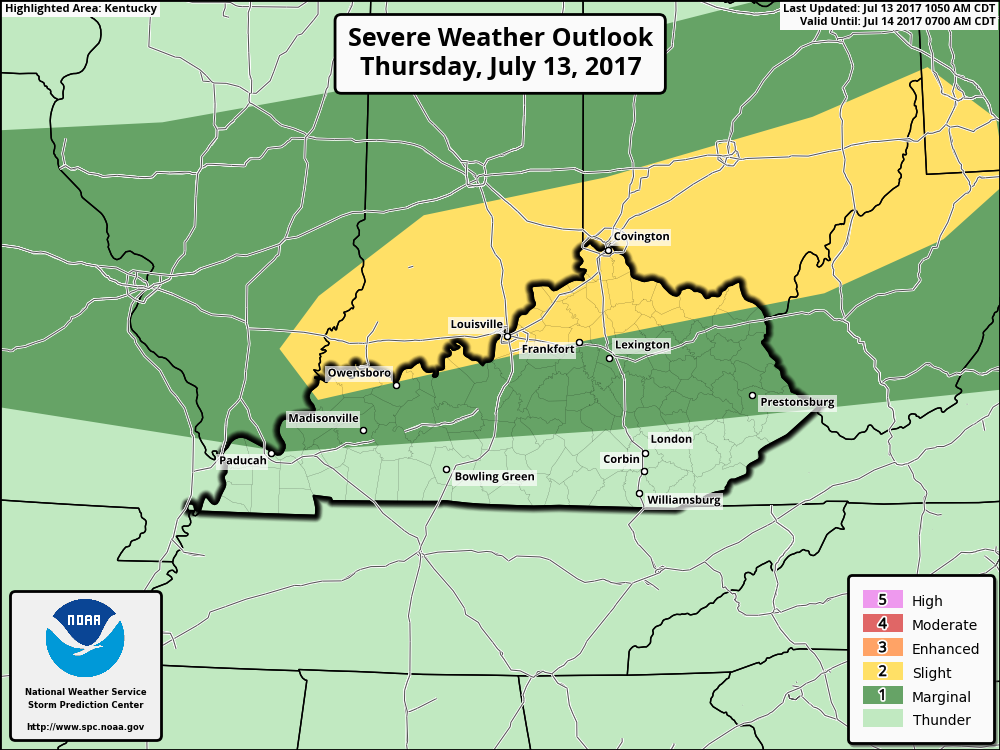
Thursday evening update: The Slight Risk Area has been expanded some for Friday. It now is from just south of Owensboro to around Elizabethtown to Richmond and then eastward to around Pikeville. Strong to severe storms are expected to develop Friday afternoon. The primary threats appear to be damaging winds/hail. An isolated tornado or two can't be ruled out. As for the timing the best time for these possible storms in Kentucky look to be after 5 pm. Update coming in the morning.
-
Our chance for severe weather continues through Friday. There is a Marginal Risk for storms later today. Mainly south and east of a line from just north of Bowling Green through Lexington. These possible storms will be scattered in nature and gusty winds and heavy rain will be the primary threats. The threat increases for some on Friday afternoon. The Storm Prediction Center has parts of Kentucky in a Slight Risk Area for strong to severe storms. This is mainly for those who are north of I-64. Strong to damaging winds will be possible along with some hail. I will update later today.
-
Almost the entire state is in a Marginal Risk Area for storms today. Isolated strong to severe storms that may produce gusty winds and hail will be possible. The timing as of this morning looks to be afternoon into early evening hours. Some of these storms also could put down some localized heavy precipitation totals. Up to 1.5" could be possible for some. Simulated Radar 2 pm to 2 am EDT EHI Rain fall totals through 5 AM EDT Thursday morning
-
HRRR simulated radar from 2 pm to 2 am EDT
-
Parts of Kentucky could be see marginally strong to severe storms later today. The Storm Prediction Center has parts of Kentucky again today in a Marginal Risk Area. Isolated strong to locally severe storms will be possible. These possible storms look to have mainly damaging winds. Everyone should be weather award later today. I don't know how much I'll be able to update because I'm on vacation. I will try and send out any warnings through our twitter page.
-
The Storm Prediction Center has parts of WKY in a Slight Risk Area for strong to severe storms for today. The main threats look to be damaging wind gust and hail. Also a slight chance of a tornado or two. Other parts of Kentucky are in a Marginal Risk Area except for EKY. For Saturday the entire state is in a Marginal Risk Area for strong to severe storms. These marginal severe storms will pose mainly a damaging wind threat. Everyone pay attention to local weather. This will probably be my only update today. As I will be traveling later today. Be weather aware today and tomorrow.
-
Thanks for the compliments. I've been asked a few times how do my forecasts compare to others. I really don't know because I don't look at other forecasts any more. In the past I found that by doing that it would affect how I read the modeling data.
-
NWS-Louisville office will be conducting a damage survey this morning in LaRue and Marion counties.
-
Not any problems at all most of the system will be out of Kentucky by that time. You may run into show showers/rain in SEKY. Temps in the mid 60s to low 70s.
-
URGENT - IMMEDIATE BROADCAST REQUESTED Tornado Watch Number 368 NWS Storm Prediction Center Norman OK 330 PM EDT Fri Jun 23 2017 The NWS Storm Prediction Center has issued a * Tornado Watch for portions of South-central and Eastern Kentucky * Effective this Friday afternoon and evening from 330 PM until 1000 PM EDT. * Primary threats include... A few tornadoes possible Isolated damaging wind gusts to 70 mph possible SUMMARY...Strong low-level/deep-layer shear and a moist environment ahead of the remnants of Cindy will result in a potential for some supercells capable of a tornado risk and damaging winds. The tornado watch area is approximately along and 65 statute miles east and west of a line from 55 miles north of Jackson KY to 50 miles southwest of London KY. For a complete depiction of the watch see the associated watch outline update (WOUS64 KWNS WOU8). PRECAUTIONARY/PREPAREDNESS ACTIONS... REMEMBER...A Tornado Watch means conditions are favorable for tornadoes and severe thunderstorms in and close to the watch area. Persons in these areas should be on the lookout for threatening weather conditions and listen for later statements and possible warnings.
-
Tornado Watch maybe issued soon.
-
Thanks, I wish I had more time to post more detailed info. I've been working 12-13 hrs days. I'm rushing now to get ready to go to work.
-
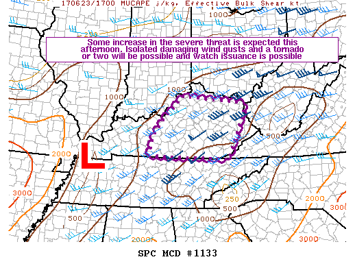
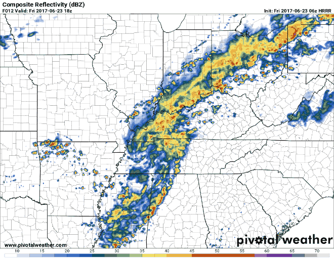
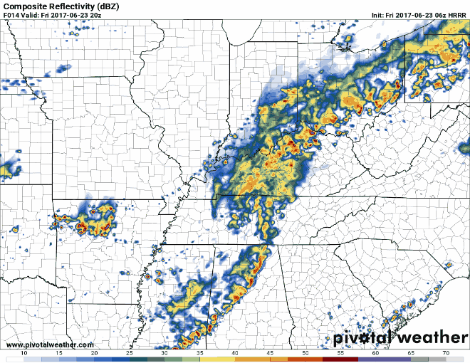
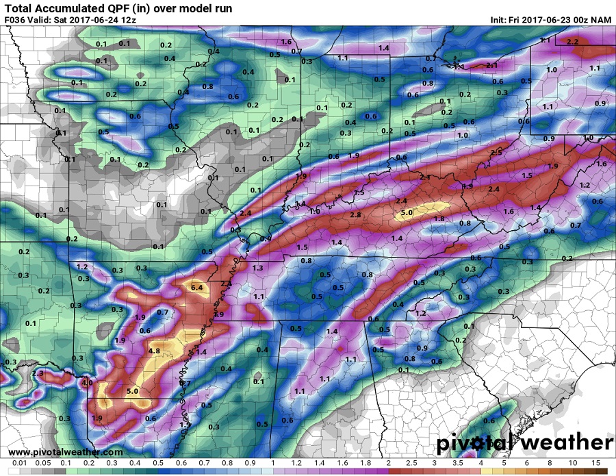
Friday morning update: Thunderstorms associated with a tornado, wind damage and isolated large hail threat will be possible this afternoon. The National Hurricane Center is forecasting the remnants of Cindy to move north-northeastward across Kentucky today. The best time for these storms seems to be between 2-8 pm EDT. I will update later today. Also warnings will be sent out on our Twitter page. Be weather aware later today. Remember that the entire state is under a flash flood watch. Predicted rain fall totals through 8 am EDT Saturday morning. Simulate radars 2-6 pm EDT 4-8 pm EDT