.png.ffa34568722b20f38e3c3ecfcb9a2cd2.png)

.jpg.dff87640c6ed93f4bdf8eebdf96f5dec.jpg)
nWo
-
Posts
25,628 -
Joined
-
Last visited
-
Days Won
5
Everything posted by nWo
-
Irma, right center, of this water vapor satellite image heading towards the Leeward Islands.
-
Brand new Tropical storm force wind map.

-
A Hurricane Watch has been issued for Antiqua for Irma. Hurricane conditions are possible within the watch area by Tuesday night. with tropical storm conditions by late Tuesday.
-
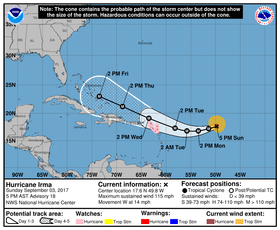
.Sunday evening 9/3/17 update Irma has been moving westward since the previous advisory, but the longer-term motion estimate is still south of due west. A strong high-pressure ridge over the central Atlantic should steer Irma westward to west-southwestward during the next couple of days. After that time a turn toward the west-northwest should occur. The models are still not in good agreement about the track of Irma. The latest track from the NHC is in the middle of what the models are showing as of now. Everyone is reminded to not focus on the exact forecast track since strong winds and heavy rainfall extend well away from the center. In fact, data indicates that the size of the tropical storm force wind field has expanded. Irma is expected to remain a dangerous major hurricane through the upcoming week. It is still too early to determine what direct impacts Irma might have in the continental US. Regardless everyone in hurricane prone areas should ensure that they have their hurricane plan in place. There is a difference in what the GFS and Canadian/GDPS are showing. The GDPS is showing Irma landfall on the evening of the hugging the eastern coast of Flordia before making landfall on the evening of the 10th. While the GFS is showing a more northerly turn and staying off the shore until the evening of the 11th and Irma making landfall in North Carolina. So this shows the difficulty of predicting Irma's effect on the US east coast this far out. If you have interest in the possible landfall areas keep checking back for daily updates. Here are the latest 5-day movement track and wind field maps from the National Hurricane Center.
-
Sunday morning update 9/3/17 at 5:00 AM EDT Irma is moving toward the west-southwest near 15 mph. A turn to the west is expected on Monday. Maximum sustained winds have increased to near 115 mph with higher gusts. Irma is now a category 3 hurricane on the Saffir-Simpson Hurrican Wind Scale. Some additional strengthening is forecast through Monday night. The environment ahead of Irma appears conducive for gradual strengthening for at least the next 2 to 3 days. There may be some fluctuations in intensity, but overall the models seem to suggest a general upward trend in intensity with a peak around day 3. This type of intensification would coincide with the timing of Irma's west-southwest to a westward motion. a pattern which other west-southwestward moving hurricanes in the past (i.e. Katrina, Joaquin, Fernanda, etc.) have followed. It is still much too early to determine what direct impact Irma will have in the continental United States. Regardless everyone in hurricane prone areas should ensure that they have their hurricane plan in place. Those who have interests in those same areas should also pay attention to the forecast in the upcoming days. Here is the latest 5-day path map from the National Hurrican Center. Here is what both the GFS and the GDPS are showing this morning. Both are showing a more southerly possibility than yesterday. The GFS is back to showing a possible northerly turn on the 10th and then land fall in North Carolina just north of Myrtle Beach on the 11th. The Canadian GDPS is showing land fall in Florida between Miami and West Palm Beach on the 10th. Keep checking back for updates.
-
Keep a close eye on Irma. I just checked the latest GFS and Canadian/GDPS models. They both are bringing Irma's possible landfall back southward some. I'll be posting daily updates and as we get closer I'll be posting them more frequently when possible.
-
If you are talking about early next week look for on and off showers and possible thunderstorms. Temps look to be from the mid 70s to low 80s. This is for all week. Now one thing I want to mention next weekend around the 10th maybe Hurricane Irma may be in the area. Nothing definite on that yet.
-
Thanks for the compliment. Keep your eye on Tuesday. Your area may get 1-2 inches of rain from showers and maybe strong thunderstorms. Don't see anything really severe yet.
-
Irma continues to fluctuate in strength but remains a powerful Hurricane. Maximum sustained winds near 110 mph with higher gusts. Fluctuations in strength up or down are possible during the next couple of days but Irma is expected to remain a powerful hurricane into next week. Irma is now at the high end of a category 2 hurricane. The latest GFS has Irma taking a northerly turn and making landfall in the Maryland/New Jersey area on the 10th. As we have seen the track has been changing so those from Florida up the east coast should be paying close attention to Irma starting early to mid next week.
-
48-hour rainfall totals as of 8:30 Friday 8/1/17. http://www.weather.gov/media/lmk/pdf/harvey_aug31_2017/RainfallReports_830PM.pdf
-
Irma is in the bottom right corner.
-
Here is the latest track just released by the National Hurricane Center at 5 pm EDT. It also shows the start of the northerly turn of Irma.
-
The latest model data that I use shows Irma taking a more northerly turn. The long range GFS and the Canadian/GDPS have Irma going up the east coast and not making landfall. The GDPS has Irma close to the Florida Coast and the GFS has it staying off the coast. Remember these are just a snap shot in time and could change and probably will by next week. This morning the GDPS had Irma crossing south Florida and going into the Gulf of Mexico. Those in the areas I mentioned this morning should still pay attention to the track of this storm. GFS Model Canadian/GDPS
-
I think it will mainly be 1-2 inches from around I-64 northward for EKY.
-
Long range I like the GFS and to a lesser extent GDPS/Candian model two or three days out the NAM and NAM 3km CONUS The day of the event the HRRR model
-
Rainfall totals for Jefferson County through 7 am this morning. Louisville is looking at maybe another 1-2" by this evening.
-
You should be ok. I'm not seeing any thing close to Florida around the 10th if Irma takes a more southerly track.
-
Not all models have the same data input and each model have a different way the mathematical problems are solved. It also depends on the weather situation. Some do well on a particular weather situation while others don't in the same situation. It also depends on the geographical location of this situation. Some do well while others don't. That is why I will check several models before I really post anything unless I feel the information should be posted to give our members a heads up. When the models come into agreement as you get closer to a weather event that means they are all doing pretty well with that event. Also the further away you are from a weather event it is more difficult for the models to accurately predict what will happen. Also, some models are only refreshed every 12 hrs. Some every 6 hrs and then some every 3 or 1 hrs. So you can see why there is such a variance in the models predicting the weather until you get close to the even.t
-
I'll be keeping a close eye on it. For now, the GFS has it heading towards the Carolinas. The Canadian model I just checked has it going through south Florida into the Gulf of Mexico on the 10th. So everyone can see the track is still up in the air. That is why I said people from the Carribean to the Carolinas should keep and eye on this powerful storm.
-
Maybe in a week or so give a day or two. I'm going to be watching this closer than I planned because of how quickly it intensified.
-
Rain fall totals as of 7 am this morning from Warren County.
-
Irma is now a major Cat 3 hurricane with winds greater than 110 mph. The models are all over the place with the track of Irma. Those from the Carribean, Flordia and the Carolinas should follow the progress of this storm's path. Reading some reports about Irma they say it formed in the same area as Hugo, Floyd, and Ivan. This area has been known to produce some of the largest and most intense hurricanes. Now I'm not saying Irma will take the same track as one of the storms named. The models should start getting a hold on the possible track of Irma early next week. I wanted to start a new thread because of how quickly Irma strengthen. Information on hurricanes I mentioned. Hugo Floyd Ivan
-
The National Weather Service in Louisville has issued a * Flood Warning for... Northern Logan County in central Kentucky... Butler County in south central Kentucky... Grayson County in central Kentucky... Warren County in south central Kentucky... Ohio County in central Kentucky... Edmonson County in south central Kentucky... * Until 130 PM CDT Friday * At 723 AM CDT, local law enforcement reported heavy rain has caused high water closing many roads in northern Logan and Warren counties. Continued rain in Butler, Edmonson, Grayson, and Ohio counties is expected to create flooding problems soon. The Flood Warning will replace the Flash Flood Warning. * Some locations that will experience flooding include... Bowling Green, Leitchfield, Hartford, Morgantown, Brownsville, Plum Springs, Memphis Junction, Mount Victor, Crestmoor and Anderson. PRECAUTIONARY/PREPAREDNESS ACTIONS... Turn around, don`t drown when encountering flooded roads. Most flood deaths occur in vehicles.
-
Just looked at the latest radar simulations. The West Virginia route looks to see less rain than the Ohio route today. Parts of Southern Ohio and Eastern Kentucky are looking at 1-3 inches of rain by tonight. For Saturday you'll see light showers and rain over the entire Ohio and West Virginia areas.
.thumb.jpg.dc448957daf4ddf2823660190e844abb.jpg)


.gif.0f8a67a5e07c0926a7b18d52a5bce238.gif)

