.png.ffa34568722b20f38e3c3ecfcb9a2cd2.png)

.jpg.dff87640c6ed93f4bdf8eebdf96f5dec.jpg)
nWo
-
Posts
25,628 -
Joined
-
Last visited
-
Days Won
5
Everything posted by nWo
-
A tornado warning for southeastern Broward and northeastern Miami-Dade counties expired at 8:15 p.m. Saturday, after a series of thunderstorms and tornado sightings led the National Weather Service to urge residents to take cover. The thunderstorm that prompted the warning became too weak to produce tornadoes, the weather service said. But the service said it had confirmed a “large and dangerous tornado” that swept west through central Broward County toward the Everglades. But a tornado watch, which means the conditions exists to produce tornadoes, will continue for southeastern Florida until midnight, the National Weather Service said. At 7:40 p.m. a tornado was confirmed at Interstate 75 and U.S. 27 near Alligator Alley, moving west at 35 mph, the National Weather Service said. The tornado was located earlier over central Broward. http://www.sun-sentinel.com/news/weather/hurricane/fl-reg-hurricane-irma-saturday-20170909-story.html
-
FLZ043-050-052-056-057-061-139-142-148-149-151-155-160-162-165-239-242-248-249-251-255-260-262-265-100700- Hurricane Irma Local Statement Advisory Number 43 National Weather Service Tampa Bay Ruskin FL AL112017 655 PM EDT Sat Sep 9 2017 This product covers West Central and Southwest Florida **EYE OF IRMA BEGINNING TO MOVE SLOWLY AWAY FROM THE COAST OF CUBA WHILE WEATHER IS DETERIORATING IN SOUTH FLORIDA** NEW INFORMATION --------------- * CHANGES TO WATCHES AND WARNINGS: - None * CURRENT WATCHES AND WARNINGS: - A Hurricane Warning is in effect for DeSoto, Hardee, Highlands, Inland Charlotte, Inland Citrus, Inland Hernando, Inland Hillsborough, Inland Levy, Inland Manatee, Inland Pasco, Inland Sarasota, Polk, and Sumter - A Storm Surge Warning and Hurricane Warning are in effect for Coastal Charlotte, Coastal Citrus, Coastal Hernando, Coastal Hillsborough, Coastal Lee, Coastal Levy, Coastal Manatee, Coastal Pasco, Coastal Sarasota, Inland Lee, and Pinellas * STORM INFORMATION: - About 320 miles south-southeast of Mouth of Tampa Bay FL or about 240 miles south-southeast of Fort Myers FL - 23.4N 80.5W - Storm Intensity 125 mph - Movement West-northwest or 295 degrees at 9 mph SITUATION OVERVIEW ------------------ Dangerous Hurricane Irma is moving west northwest away from the north coast of Cuba and is forecast to approach the southwest Florida coast as a major hurricane Sunday morning. Irma is forecast to move over the Western Florida peninsula Sunday through early Monday morning as a strong hurricane. Winds will gust to tropical storm force as fast-moving squalls move onshore tonight across southwest Florida. These will increase in frequency and intensity overnight as the outer rainbands of Irma spread north along the peninsula. Given the current forecast track, a period of damaging winds is expected across ALL of west-central and southwest Florida Sunday afternoon into Monday morning. POTENTIAL IMPACTS ----------------- * WIND: Protect against life-threatening wind having possible devastating impacts across West Central and Southwest Florida. Potential impacts include: - Structural damage to sturdy buildings, some with complete roof and wall failures. Complete destruction of mobile homes. Damage greatly accentuated by large airborne projectiles. Locations may be uninhabitable for weeks or months. - Numerous large trees snapped or uprooted along with fences and roadway signs blown over. - Many roads impassable from large debris, and more within urban or heavily wooded places. Many bridges, causeways, and access routes impassable. - Widespread power and communications outages. * SURGE: Protect against life-threatening surge having possible devastating impacts across the Nature Coast southward through Tampa Bay and then all of southwest Florida. Potential impacts in this area include: - Widespread deep inundation, with storm surge flooding greatly accentuated by powerful battering waves. Structural damage to buildings, with many washing away. Damage greatly compounded from considerable floating debris. Locations may be uninhabitable for an extended period. - Near-shore escape routes and secondary roads washed out or severely flooded. Flood control systems and barriers may become stressed. - Extreme beach erosion. New shoreline cuts possible. - Massive damage to marinas, docks, boardwalks, and piers. Numerous small craft broken away from moorings with many lifted onshore and stranded. * FLOODING RAIN: Protect against life-threatening rainfall flooding having possible devastating impacts across west-central and southwest Florida. Potential impacts include: - Extreme rainfall flooding may prompt numerous evacuations and rescues. - Rivers and tributaries may overwhelmingly overflow their banks in many places with deep moving water. Small streams, creeks, canals, and ditches may become raging rivers. Flood control systems and barriers may become stressed. - Flood waters can enter numerous structures within multiple communities, some structures becoming uninhabitable or washed away. Numerous places where flood waters may cover escape routes. Streets and parking lots become rivers of raging water with underpasses submerged. Driving conditions become very dangerous. Numerous road and bridge closures with some weakened or washed out. * TORNADOES: Protect against a tornado event having possible limited impacts across West Central and Southwest Florida. Potential impacts include: - The occurrence of isolated tornadoes can hinder the execution of emergency plans during tropical events. - A few places may experience tornado damage, along with power and communications disruptions. - Locations could realize roofs peeled off buildings, chimneys toppled, mobile homes pushed off foundations or overturned, large tree tops and branches snapped off, shallow-rooted trees knocked over, moving vehicles blown off roads, and small boats pulled from moorings. PRECAUTIONARY/PREPAREDNESS ACTIONS ---------------------------------- * EVACUATIONS: For those under evacuation orders, leave as soon as practical with a destination in mind. Gas up your vehicle well ahead of time. Be sure that you take all essential materials from your emergency supplies kit. Let others know where you are going and when you intend to arrive. If evacuating the area, stick to prescribed evacuation routes. Look for additional traffic information on roadway smart signs and listen to select radio channels for further travel instructions. Drivers should not use cell phones while operating vehicles. For those not under evacuation orders, understand that there are inherent risks to evacuation (such as traffic congestion, accidents, and driving in bad weather), so evacuate only if necessary. Help keep roadways open for those that are under evacuation orders. If you are exceptionally vulnerable to wind or water hazards from tropical systems, consider voluntary evacuation, especially if being officially recommended. Relocate to a predetermined shelter or safe destination. If evacuating away from the area or relocating to a nearby shelter, leave early before weather conditions become hazardous. Levy County: Levy County Emergency Management Citrus County: Citrus County Sheriff’s Office, Law Enforcement, Police Department Inverness Florida Sumter County: Sumter County, FL - Official Website | Official Website Hernando County: Welcome to Hernando County, Florida Pasco County: Pasco County, FL - Official Website Pinellas County: http://www.pinellascounty.org Hillsborough County: http://www.hillsboroughcounty.org Polk County: http://www.polk-county.net Manatee County: http://www.mymanatee.org Hardee County: http://www.hardeecounty.net Desoto County: http://www.desotobocc.com Sarasota County: http://www.scgov.net Highlands County: http://www.hcbcc.net Charlotte County: http://www.charlottecountyfl.gov Lee County: http://www.leegov.com * OTHER PREPAREDNESS INFORMATION: Now is the time to bring to completion all preparations to protect life and property in accordance with your emergency plan. Outside preparations should be wrapped up as soon as possible before weather conditions completely deteriorate. Any remaining evacuations and relocations should be expedited before the onset of tropical storm force wind. Failure to adequately shelter may result in serious injury or loss of life. Always heed the advice of local officials and comply with any orders that are issued. Remember, during the storm 9 1 1 Emergency Services may not be able to immediately respond if conditions are unsafe. This should be a big factor in your decision making. Check-in with your emergency points of contact among family, friends, and workmates. Inform them of your status and well-being. Let them know how you intend to ride out the storm and when you plan to check-in again. Keep cell phones well charged and handy. Also, cell phone chargers for automobiles can be helpful after the storm. Locate your chargers and keep them with your cell phone. Closely monitor NOAA Weather radio or other local news outlets for official storm information. Be ready to adapt to possible changes to the forecast. * ADDITIONAL SOURCES OF INFORMATION: - For information on appropriate preparations see ready.gov - For information on creating an emergency plan see getagameplan.org - For additional disaster preparedness information see redcross.org NEXT UPDATE ----------- The next local statement will be issued by the National Weather Service in Tampa Bay Ruskin FL around 12 AM, or sooner if conditions warrant.
-
Follow the latest updates on Irma on our twitter page. http://bluegrasspreps.com/bgp-break-room/bgp-com-weather-342822.html
-
I've seen were Andrew was 4-5 hrs. Now they are saying Florida may see 30 hrs worth.
-
I just received this from the NWS. FLZ043-050-052-056-057-061-139-142-148-149-151-155-160-162-165-239-242-248-249-251-255-260-262-265-100045- Hurricane Irma Local Statement Advisory Number 42 National Weather Service Tampa Bay Ruskin FL AL112017 1244 PM EDT Sat Sep 9 2017 This product covers West Central and Southwest Florida **IRMA CONTINUES TO POUND THE NORTH COAST OF CUBA** NEW INFORMATION --------------- * CHANGES TO WATCHES AND WARNINGS: - The Hurricane Watch has been upgraded to a Hurricane Warning for Inland Citrus and Inland Levy - The Hurricane Watch has been upgraded to a Hurricane Warning and a Storm Surge Warning have been issued for Coastal Citrus and Coastal Levy * CURRENT WATCHES AND WARNINGS: - A Storm Surge Warning and Hurricane Warning are in effect for Coastal Charlotte, Coastal Citrus, Coastal Hernando, Coastal Hillsborough, Coastal Lee, Coastal Levy, Coastal Manatee, Coastal Pasco, Coastal Sarasota, Inland Lee, and Pinellas - A Hurricane Warning is in effect for DeSoto, Hardee, Highlands, Inland Charlotte, Inland Citrus, Inland Hernando, Inland Hillsborough, Inland Levy, Inland Manatee, Inland Pasco, Inland Sarasota, Polk, and Sumter * STORM INFORMATION: - About 290 miles south-southeast of Fort Myers FL - 22.8N 79.8W - Storm Intensity 125 mph - Movement West or 280 degrees at 9 mph SITUATION OVERVIEW ------------------ Hurricane Irma is moving toward the west along the north coast of Cuba with a turn to the northwest expected late today and then toward the north-northwest tonight or Sunday. On the forecast track, the center of the storm will be near the Florida Keys Sunday morning and then approach the southwest Florida coast Sunday afternoon. POTENTIAL IMPACTS ----------------- * WIND: Protect against life-threatening wind having possible devastating impacts across West Central and Southwest Florida. Potential impacts include: - Structural damage to sturdy buildings, some with complete roof and wall failures. Complete destruction of mobile homes. Damage greatly accentuated by large airborne projectiles. Locations may be uninhabitable for weeks or months. - Numerous large trees snapped or uprooted along with fences and roadway signs blown over. - Many roads impassable from large debris, and more within urban or heavily wooded places. Many bridges, causeways, and access routes impassable. - Widespread power and communications outages. * SURGE: Protect against life-threatening surge having possible devastating impacts across the Nature Coast southward through Tampa Bay and then all of southwest FLorida. Potential impacts in this area include: - Widespread deep inundation, with storm surge flooding greatly accentuated by powerful battering waves. Structural damage to buildings, with many washing away. Damage greatly compounded from considerable floating debris. Locations may be uninhabitable for an extended period. - Near-shore escape routes and secondary roads washed out or severely flooded. Flood control systems and barriers may become stressed. - Extreme beach erosion. New shoreline cuts possible. - Massive damage to marinas, docks, boardwalks, and piers. Numerous small craft broken away from moorings with many lifted onshore and stranded. * FLOODING RAIN: Protect against life-threatening rainfall flooding having possible devastating impacts across west-central and southwest Florida. Potential impacts include: - Extreme rainfall flooding may prompt numerous evacuations and rescues. - Rivers and tributaries may overwhelmingly overflow their banks in many places with deep moving water. Small streams, creeks, canals, and ditches may become raging rivers. Flood control systems and barriers may become stressed. - Flood waters can enter numerous structures within multiple communities, some structures becoming uninhabitable or washed away. Numerous places where flood waters may cover escape routes. Streets and parking lots become rivers of raging water with underpasses submerged. Driving conditions become very dangerous. Numerous road and bridge closures with some weakened or washed out. * TORNADOES: Protect against a dangerous tornado event having possible significant impacts across west-central and southwest Florida. Potential impacts include: - The occurrence of scattered tornadoes can hinder the execution of emergency plans during tropical events. - Several places may experience tornado damage with a few spots of considerable damage, power loss, and communications failures. - Locations could realize roofs torn off frame houses, mobile homes demolished, boxcars overturned, large trees snapped or uprooted, vehicles tumbled, and small boats tossed about. Dangerous projectiles can add to the toll. PRECAUTIONARY/PREPAREDNESS ACTIONS ---------------------------------- * EVACUATIONS: For those under evacuation orders, leave as soon as practical with a destination in mind. Gas up your vehicle well ahead of time. Be sure that you take all essential materials from your emergency supplies kit. Let others know where you are going and when you intend to arrive. If evacuating the area, stick to prescribed evacuation routes. Look for additional traffic information on roadway smart signs and listen to select radio channels for further travel instructions. Drivers should not use cell phones while operating vehicles. For those not under evacuation orders, understand that there are inherent risks to evacuation (such as traffic congestion, accidents, and driving in bad weather), so evacuate only if necessary. Help keep roadways open for those that are under evacuation orders. If you are exceptionally vulnerable to wind or water hazards from tropical systems, consider voluntary evacuation, especially if being officially recommended. Relocate to a predetermined shelter or safe destination. If evacuating away from the area or relocating to a nearby shelter, leave early before weather conditions become hazardous. Levy County: Levy County Emergency Management Citrus County: Citrus County Sheriff’s Office, Law Enforcement, Police Department Inverness Florida Sumter County: Sumter County, FL - Official Website | Official Website Hernando County: Welcome to Hernando County, Florida Pasco County: Pasco County, FL - Official Website Pinellas County: http://www.pinellascounty.org Hillsborough County: http://www.hillsboroughcounty.org Polk County: http://www.polk-county.net Manatee County: http://www.mymanatee.org Hardee County: http://www.hardeecounty.net Desoto County: http://www.desotobocc.com Sarasota County: http://www.scgov.net Highlands County: http://www.hcbcc.net Charlotte County: http://www.charlottecountyfl.gov Lee County: http://www.leegov.com * OTHER PREPAREDNESS INFORMATION: Now is the time to bring to completion all preparations to protect life and property in accordance with your emergency plan. Outside preparations should be wrapped up as soon as possible before weather conditions completely deteriorate. Any remaining evacuations and relocations should be expedited before the onset of tropical storm force wind. If you are relocating to safe shelter, leave as early as possible. If heading to a community shelter, become familiar with the shelter rules before arrival, especially if you have special needs or own a pet. Take essential items with you from your Emergency Supplies Kit. Check the latest weather forecast before departing. Failure to adequately shelter may result in serious injury or loss of life. Always heed the advice of local officials and comply with any orders that are issued. Remember, during the storm 9 1 1 Emergency Services may not be able to immediately respond if conditions are unsafe. This should be a big factor in your decision making. Check-in with your emergency points of contact among family, friends, and workmates. Inform them of your status and well-being. Let them know how you intend to ride out the storm and when you plan to check-in again. Keep cell phones well charged and handy. Also, cell phone chargers for automobiles can be helpful after the storm. Locate your chargers and keep them with your cell phone. In emergencies it is best to remain calm. Stay informed and focused on the situation at hand. Exercise patience with those you encounter. Be a Good Samaritan and helpful to others. If relocating to a nearby shelter or to the home of a family member or friend, drive with extra caution, especially on secondary roads. Remember, many bridges and causeways will be closed once higher winds arrive. Also, if you encounter water covering the road, seek an alternate route. Always obey official road signs for closures and detours. If you are a visitor and still in the area, listen for the name of the city or town in which you are staying within local news updates. Be sure you know the name of the county or parish in which it resides. Pay attention for instructions from local authorities. Closely monitor NOAA Weather radio or other local news outlets for official storm information. Be ready to adapt to possible changes to the forecast. * ADDITIONAL SOURCES OF INFORMATION: - For information on appropriate preparations see ready.gov - For information on creating an emergency plan see getagameplan.org - For additional disaster preparedness information see redcross.org NEXT UPDATE ----------- The next local statement will be issued by the National Weather Service in Tampa Bay Ruskin FL around 6 PM, or sooner if conditions warrant.
-
Updates will start coming every hour from the National Hurricane Center until the eye of Irma is no longer visible on radar.
-
Tornado Warning just issued for Colier County, FL
-
Third one. 1001 AM EDT Sat Sep 9 2017 ...Forecast flooding increased from Minor to Record severity...The Flood Warning continues for The Hillsborough River At Morris Bridge * Until further notice * At 10 AM Saturday the stage was...30.3 feet. * Record flooding is forecast. * Flood stage is 32.0 feet. * The river is forecast to rise above flood stage by early Tuesday morning and continue to rise to near 34.9 feet by early Thursday morning. Additional rises are possible thereafter. * Impact...at 35.0 feet...Portions of Morris Bridge road about 3/4 of a mile south of the bridge begin to flood. * Impact...at 32.0 feet...Flooding begins at a trailer park downstream from Morris Bridge and just upstream from the northern end of the Tampa Bypass canal. * Flood history...This crest compares to a previous crest of 34.4 feet on Sep 8 2004. &&
-
Another one 1001 AM CDT Sat Sep 9 2017 The National Weather Service in Tampa Fl has issued a * Flood Warning for The Alafia River At Riverview * From late Sunday night until further notice. * At 09 AM Saturday the stage was...0.9 feet. * Record flooding is forecast. * Flood stage is 4.2 feet. * Impact...at 4.2 feet...Water begins to impact homes on Pine Avenue and Park Drive. * Flood history...This crest compares to a previous crest of 6.2 feet on Sep 6 2004.
-
I just received this text. Flood Warning for Tampa Area. 1001 AM EDT Sat Sep 9 2017 ...Forecast flooding increased from Major to Record severity...The Flood Warning continues for The Hillsborough River Near Hillsborough River State Park * Until further notice * At 09 AM Saturday the stage was...3.7 feet. * Record flooding is forecast. * Flood stage is 10.0 feet. * The river is forecast to rise above flood stage by tomorrow late evening and continue to rise to near 16.0 feet by early Tuesday morning. * Impact...at 13.4 feet...Streets in Crystal Springs flood and homes are isolated, but no flooding into homes occurs. * Impact...at 11.0 feet...Hillsborough River State Park is closed. Lowland flooding occurs at the mobile home park near Branchton on State Road 579. * Impact...at 8.0 feet...Some State Park operations are suspended. * Flood history...This crest compares to a previous crest of 15.3 feet on Mar 18 1960.

-
Here's another risk from Irma that is growing before Irma makes landfall in Florida. Tornado Risk growing for south Florida. Mesoscale Discussion 1631 NWS Storm Prediction Center Norman OK 0748 AM CDT Sat Sep 09 2017 Areas affected...Portions of southeastern FL and Keys Concerning...Severe potential...Watch possible Valid 091248Z - 091615Z Probability of Watch Issuance...40 percent SUMMARY...The tornado risk, while currently on the marginal side, will increase throughout the morning and (per the forthcoming SPC convective outlook) continue to ramp up later today as more of the favorable sector of Hurricane Irma's envelope spreads across the region. As the tornado threat gradually grows, a watch may be needed at some point in the next few hours.
-
As of now looks like widespread 1-2" of rain with winds around 20 mph with higher gusts. Starting on Tuesday. Irma should be just a tropical depression by the time it reaches Kentucky.
-
While there will be a chance for strengthening as Irma passes over the warm water of the Florida straights the latest forecast discussion has westerly wind shear developing in about 24 hours that may dampen the strengthing of Irma. It will still be a very dangerous hurricane without much intensification.
-
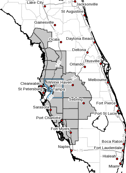
I have a severe weather alert area set up for the Tamp Area has the map shows so I get instant text notifications of impending severe weather in that area.
-
Comparison of Andrew and Irma from CNN.com How does Hurricane Irma compare to Andrew? - CNN Video
-
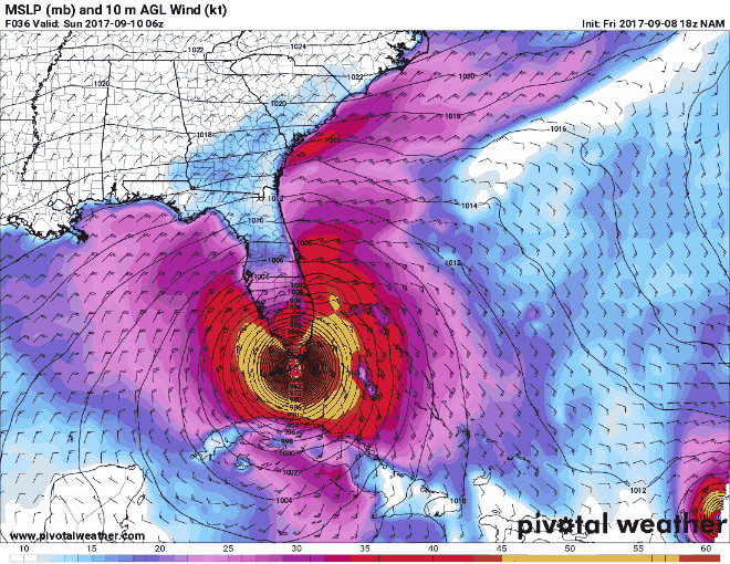
Here's the latest GFS model track of Irma. It is showing Irma as a category 4 hurricane at land fall in southwest Florida with sustained wind of around 134 mph. Here is the Saffir-Simpson Hurricane Wind Scale.
-
I know we have some members who either live in the Tampa area or have family members there. So I'm starting a thread for the Tampa Area. National Weather Service Tampa Bay Ruskin FL AL112017 1225 AM EDT Sat Sep 9 2017 This product covers West Central and Southwest Florida **HURRICANE AND STORM SURGE WARNINGS EXTENDED NORTHWARD ALONG THE FLORIDA PENINSULA** NEW INFORMATION --------------- * CHANGES TO WATCHES AND WARNINGS: - The Hurricane Watch has been upgraded to a Hurricane Warning and a Storm Surge Warning have been issued for Coastal Hillsborough and Pinellas - A Storm Surge Watch has been issued for Coastal Citrus, Coastal Hernando, Coastal Levy, and Coastal Pasco - The Storm Surge Watch has been upgraded to a Storm Surge Warning for Coastal Manatee - The Hurricane Watch has been upgraded to a Hurricane Warning for Inland Hillsborough and Polk * CURRENT WATCHES AND WARNINGS: - A Hurricane Warning is in effect for DeSoto, Hardee, Highlands, Inland Charlotte, Inland Hillsborough, Inland Manatee, Inland Sarasota, and Polk - A Storm Surge Watch and Hurricane Watch are in effect for Coastal Citrus, Coastal Hernando, Coastal Levy, and Coastal Pasco - A Storm Surge Warning and Hurricane Warning are in effect for Coastal Charlotte, Coastal Hillsborough, Coastal Lee, Coastal Manatee, Coastal Sarasota, Inland Lee, and Pinellas - A Hurricane Watch is in effect for Inland Citrus, Inland Hernando, Inland Levy, Inland Pasco, and Sumter
-
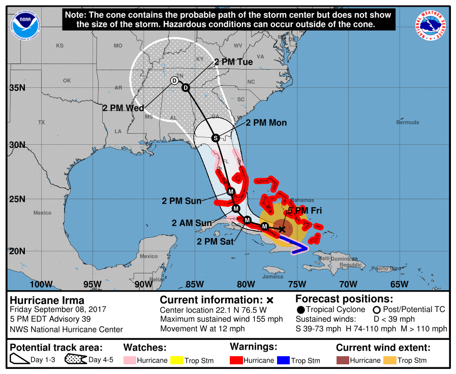
Saturday Morning 9/9/17 Update: At 500 AM EDT, the center of Hurricane Irma was located near latitude 22.5 North, longitude 78.8 West. Irma is moving toward the west-northwest near 12 mph. A turn toward the northwest is expected by late today, with a turn toward the north-northwest expected tonight or on Sunday. On the forecast track, the center of Irma will move near the north coast of Cuba today, near the Florida Keys Sunday morning, and then near the southwest coast of Florida Sunday afternoon. Maximum sustained winds are near 155 mph with higher gusts. Irma is a category 4 hurricane on the Saffir-Simpson Hurricane Wind Scale. Some fluctuations in intensity are likely during the next day or two, but Irma is expected to remain a powerful hurricane as it approaches Florida. Hurricane-force winds extend outward up to 70 miles from the center and tropical-storm-force winds extend outward up to 195 miles.
-
Hurricane Irma Local Statement Advisory Number 39 National Weather Service Tampa Bay Ruskin FL AL112017 708 PM EDT Fri Sep 8 2017 This product covers West Central and Southwest Florida ..HURRICANE AND STORM SURGE WATCHES AND WARNINGS EXTENDED NORTHWARD ALONG THE FLORIDA PENINSULA... NEW INFORMATION --------------- * CHANGES TO WATCHES AND WARNINGS: - A Hurricane Watch has been issued for Coastal Citrus, Coastal Hernando, Coastal Levy, Coastal Pasco, Inland Citrus, Inland Hernando, Inland Levy, Inland Pasco, and Sumter - A Storm Surge Watch has been issued for Coastal Hillsborough and Pinellas - The Hurricane Watch has been upgraded to a Hurricane Warning and a Storm Surge Watch have been issued for Coastal Manatee - The Hurricane Watch has been upgraded to a Hurricane Warning for Coastal Charlotte, Coastal Lee, Coastal Sarasota, DeSoto, Hardee, Highlands, Inland Charlotte, Inland Lee, Inland Manatee, and Inland Sarasota * CURRENT WATCHES AND WARNINGS: - A Hurricane Watch is in effect for Coastal Citrus, Coastal Hernando, Coastal Levy, Coastal Pasco, Inland Citrus, Inland Hernando, Inland Hillsborough, Inland Levy, Inland Pasco, Polk, and Sumter - A Hurricane Warning and Storm Surge Watch are in effect for Coastal Manatee - A Hurricane Warning is in effect for DeSoto, Hardee, Highlands, Inland Charlotte, Inland Manatee, and Inland Sarasota - A Storm Surge Watch and Hurricane Watch are in effect for Coastal Hillsborough and Pinellas - A Storm Surge Warning and Hurricane Warning are in effect for Coastal Charlotte, Coastal Lee, Coastal Sarasota, and Inland Lee * STORM INFORMATION: - About 540 miles southeast of Mouth of Tampa Bay FL or about 460 miles southeast of Fort Myers FL - 22.1N 76.5W - Storm Intensity 155 mph - Movement West or 280 degrees at 12 mph
-
@swamprat 645 PM EDT Fri Sep 8 2017 ...STORM SURGE WATCH IN EFFECT... ...HURRICANE WATCH REMAINS IN EFFECT... A Storm Surge Watch means life-threatening inundation levels are possible somewhere within this area and within the next 48 hours * LOCATIONS AFFECTED - Tampa - Apollo Beach - Westchase * WIND - LATEST LOCAL FORECAST: Equivalent Cat 2 Hurricane force wind - Peak Wind Forecast: 80-100 mph with gusts to 90 mph - Window for Tropical Storm force winds: Sunday afternoon until Monday afternoon - Window for Hurricane force winds: Sunday evening until early Monday morning - CURRENT THREAT TO LIFE AND PROPERTY: Extreme - The wind threat has increased from the previous assessment. - Emergency planning should include a reasonable threat for major hurricane force wind greater than 110 mph of equivalent Category 3 intensity or higher. - To be safe, aggressively prepare for the potential of devastating to catastrophic wind impacts. Efforts should now be underway to secure all properties. - Extremely dangerous and life-threatening wind is possible. Failure to adequately shelter may result in serious injury, loss of life, or immense human suffering. - POTENTIAL IMPACTS: Devastating to Catastrophic - Structural damage to sturdy buildings, some with complete roof and wall failures. Complete destruction of mobile homes. Damage greatly accentuated by large airborne projectiles. Locations may be uninhabitable for weeks or months. - Numerous large trees snapped or uprooted along with fences and roadway signs blown over. - Many roads impassable from large debris, and more within urban or heavily wooded places. Many bridges, causeways, and access routes impassable. - Widespread power and communications outages. * STORM SURGE - LATEST LOCAL FORECAST: Life-threatening storm surge possible - Peak Storm Surge Inundation: The potential for 2-4 feet above ground somewhere within surge prone areas - Window of concern: early Sunday evening until early Monday afternoon - CURRENT THREAT TO LIFE AND PROPERTY: Moderate - The storm surge threat has remained nearly steady from the previous assessment. - Emergency planning should include a reasonable threat for dangerous storm surge flooding of greater than 3 feet above ground. - To be safe, earnestly prepare for the potential of significant storm surge flooding impacts. Evacuation efforts should now be underway. - Life-threatening inundation is possible. Failure to heed evacuation orders may result in serious injury or loss of life. Leave if evacuation orders are given for your area. Consider voluntary evacuation if recommended. Poor decisions may needlessly risk lives. - POTENTIAL IMPACTS: Significant - Areas of inundation with storm surge flooding accentuated by waves. Damage to several buildings, mainly near the coast. - Sections of near-shore escape routes and secondary roads become weakened or washed out, especially in usually vulnerable low spots. - Major beach erosion with heavy surf breaching dunes. Strong and numerous rip currents. - Moderate damage to marinas, docks, boardwalks, and piers. Several small craft broken away from moorings, especially in unprotected anchorages. * FLOODING RAIN - LATEST LOCAL FORECAST: - Peak Rainfall Amounts: Additional 4-8 inches, with locally higher amounts - CURRENT THREAT TO LIFE AND PROPERTY: Moderate - The flooding rain threat has increased from the previous assessment. - Emergency planning should include a reasonable threat for moderate flooding where peak rainfall totals notably exceed amounts conducive for flash flooding and rapid inundation. Rescues and emergency evacuations are possible. - To be safe, earnestly prepare for the potential of significant flooding rain impacts. - Dangerous flooding is possible. Failure to take action may result in serious injury or loss of life. If flood related watches and warnings are issued, heed recommended actions. - POTENTIAL IMPACTS: Significant - Moderate rainfall flooding may prompt several evacuations and rescues. - Rivers and tributaries may quickly become swollen with swifter currents and overspill their banks in a few places, especially in usually vulnerable spots. Small streams, creeks, canals, and ditches overflow. - Flood waters can enter some structures or weaken foundations. Several places may experience expanded areas of rapid inundation at underpasses, low-lying spots, and poor drainage areas. Some streets and parking lots take on moving water as storm drains and retention ponds overflow. Driving conditions become hazardous. Some road and bridge closures. * TORNADO - LATEST LOCAL FORECAST: - Situation is favorable for tornadoes - CURRENT THREAT TO LIFE AND PROPERTY: Moderate - The tornado threat has increased from the previous assessment. - Emergency planning should include a reasonable threat for scattered tornadoes, with a few possibly strong in intensity. - To be safe, earnestly prepare for the potential of significant tornado impacts. - Listen for tornado watches and warnings. Be ready to shelter quickly if a tornado approaches. - POTENTIAL IMPACTS: Significant - The occurrence of scattered tornadoes can hinder the execution of emergency plans during tropical events. - Several places may experience tornado damage with a few spots of considerable damage, power loss, and communications failures. - Locations could realize roofs torn off frame houses, mobile homes demolished, boxcars overturned, large trees snapped or uprooted, vehicles tumbled, and small boats tossed about. Dangerous projectiles can add to the toll.
-
Latest GFS track NAM
-
I'm not liking the westward trend. Especially for the east coast of Florida. Reason being if Irma keeps on the present track the most dangerous part of the storm will pass right over it. Of course, it will be devasting over any part of Florida it passes over.
-
Thoughts are now that Hurricane Irma may strengthen to a category 5 Hurricane before it makes landfall in Florida.
-
5 pm CDT Update: WATCHES AND WARNINGS -------------------- CHANGES WITH THIS ADVISORY: The Hurricane Warning has been extended northward for east coast of Florida to Sebastian Inlet, and along the west coast of the peninsula northward to Anna Maria Island. The Hurricane Watch has been extended northward along the west coast of Florida to Suwannee River. A Storm Surge Watch has been issued north of Venice to the Anclote River, including Tampa Bay, and from Ponce Inlet to the Flagler/ Volusia County Line. SUMMARY OF WATCHES AND WARNINGS IN EFFECT: A Storm Surge Warning is in effect for... * Sebastian Inlet southward around the Florida peninsula to Venice * Florida Keys A Storm Surge Watch is in effect for... * North of Sebastian Inlet to the Flagler/Volusia County line * North of Venice to Anclote River * Tampa Bay A Hurricane Warning is in effect for... * Sebastian Inlet southward around the Florida peninsula to Anna Maria Island * Florida Keys * Lake Okeechobee * Florida Bay * Southeastern Bahamas * Cuban provinces of Camaguey, Ciego de Avila, Sancti Spiritus, and Villa Clara * Central Bahamas * Northwestern Bahamas A Hurricane Watch is in effect for... * North of Sebastian Inlet to the Flagler/Volusia County Line * North of Anna Maria Island to the Suwannee River * Cuban provinces of Guantanamo, Holguin, Las Tunas and Matanzas A Tropical Storm Warning is in effect for... * Cuban provinces of Guantanamo, Holguin, and Las Tunas A Storm Surge Warning means there is a danger of life-threatening inundation, from rising water moving inland from the coastline, during the next 36 hours in the indicated locations. For a depiction of areas at risk, please see the National Weather Service Storm Surge Watch/Warning Graphic, available at hurricanes.gov. This is a life-threatening situation. Persons located within these areas should take all necessary actions to protect life and property from rising water and the potential for other dangerous conditions. Promptly follow evacuation and other instructions from local officials. A Storm Surge Watch means there is a possibility of life- threatening inundation, from rising water moving inland from the coastline, in the indicated locations during the next 48 hours. For a depiction of areas at risk, please see the National Weather Service Storm Surge Watch/Warning Graphic, available at hurricanes.gov. A Hurricane Warning means that hurricane conditions are expected somewhere within the warning area. Preparations to protect life and property should be rushed to completion. A Hurricane Watch means that hurricane conditions are possible within the watch area. A watch is typically issued 48 hours before the anticipated first occurrence of tropical-storm-force winds, conditions that make outside preparations difficult or dangerous. A Tropical Storm Warning means that tropical storm conditions are expected somewhere within the warning area.
-
I'll be back soon. Worked till 4 am this morning then drove to Bowling Green to attend Grandparents Day at Bristow Elementary. I'm tired and getting ready to get some rest.
.thumb.jpg.dc448957daf4ddf2823660190e844abb.jpg)
.png.49579a553e1a5150020e404609c0e975.png)