.png.ffa34568722b20f38e3c3ecfcb9a2cd2.png)


nWo
-
Posts
25,746 -
Joined
-
Last visited
-
Days Won
5
Everything posted by nWo
-
Tuesday evening update. Just to show what I'm seeing. The models are coming into agreement about a system affecting Kentucky that could quite possibly give us several inches of snow. The timing is still a little off between the different models but as everyone will be able to see we may be in for an eventful weekend. Let me caution everyone this is not an official snow accumulation forecast. We are still a couple of days away and things could change in the coming days. First, the GFS model showing the accumulated snowfall through Saturday morning. Second the Canadian Model through Saturday afternoon This is at the very end of the NAM's outlook period but it is also showing some snow. This view is through Saturday morning. We will just have to wait and see if how all of this turns out. I'll post an update in the morning. Once again these are not an official call for snow accumulations.

-
That is correct if that holds.
-
Just a quick update. The chances of several inches of snow are possible this upcoming weekend. The models are in agreement about the snow just the timing and where the most snow accumulations are in doubt. Update later today.
-
The highs on Thursday look to be in the low to mid 50s. Friday the highs could fall into the mid to low 20s.
-
We went from cold to warm temps to begin the week. To end the week we are looking at the opposite. Temps look to fall around 30 degrees in about 24 to 36 hours. We also should see rain change to snow over that same period. This system is looking like it may be more potent than the one we saw this past weekend. Updates in the morning.
-
Thursday you should be ok. Friday Snow will look to be moving in that afternoon into the evening hours. Most of the snow looks to fall Friday night. Some of this could be affecting Kentucky as well.
-
Here are the very latest maps for today. I'm getting ready to head to work. Be safe driving this morning. There's a system that looks like it may affect Kentucky this weekend. I'll post something about it later today.
-
Early Monday morning update. One good thing of note is that the freezing rain accumulation totals have come down a bit. Also, the snow seems to have moved further north as the maps below will show. I will try and give one more update before I have to leave for work. Even with the totals coming down the roads could become slippery and hazardous for the morning commute. Everyone, please be careful if you have to travel this morning.
-
-
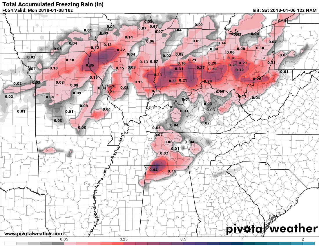
Here is the very latest modeling data. This looks more like a freezing rain event that a snow event. That's accumulation wise. The possible freezing rain accumulation totals have seemed to rise since this morning. For now, it looks like most if not all of any possible snow will be around the Ohio River northward. Parts of NKY may see a dusting to around 1/2 inch. The freezing rain looks like it will reach the I-75 corridor around 4-5 am ET. It should be ending by around 10 am EDT. Once the temps rise above freezing the snow/freezing rain will change over to all rain. I need to caution everyone that because the air temps rise above freezing the ground temps will take a little while longer to get above freezing. I saw a report from the NWS said that the ground is frozen down to a depth of around 4.5 inches. So travel early on Monday will have its challenges. Here are the latest freezing rain totals from the NAM. Here is the latest radar simulation I will update later this evening.
-
As expected a Winter Weather Advisory has been issued for parts of Kentucky. Some could see the whole range of wintry weather. It looks like possible snow accumulations will be north of I-64 where some could possibly see upwards of an inch of snow on the ground before the switch over to freezing rain. Those in the area with the possible snow accumulations can also expect around a .10 inch accumulation of freezing rain. As of this morning, the areas that could receive the most freezing rain accumulation looks to be from around Madison County eastward to parts of eastern Kentucky. The area could receive .15-.20 inches of freezing rain before the change over to a cold rain on Monday. The timing looks to be after midnight ET and continue during the morning on Monday. Here's a look at the NAM simulated radar. Here's a chart to show everyone what they could expect from the freezing rain accumulations.
-
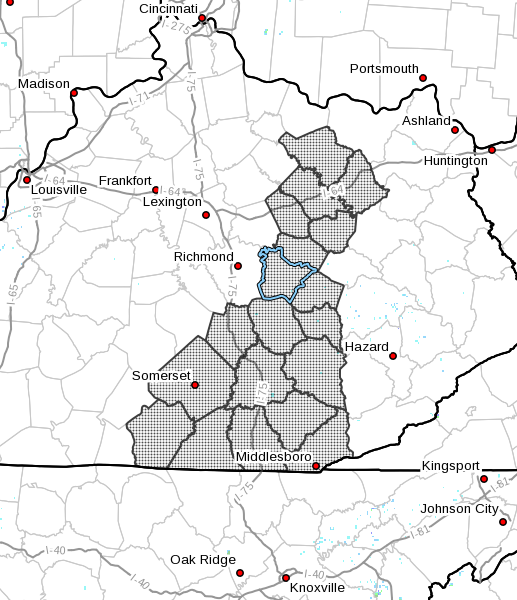
Fleming-Montgomery-Bath-Rowan-Estill-Powell-Menifee-Rockcastle- Jackson-Pulaski-Laurel-Wayne-McCreary-Whitley-Knox-Bell-Lee- Owsley-Clay- Including the cities of Flemingsburg, Camargo, Jeffersonville, Mount Sterling, Owingsville, Morehead, Irvine, Ravenna, Clay City, Stanton, Frenchburg, Brodhead, Mount Vernon, McKee, Annville, Burnside, Somerset, London, Monticello, Stearns, Whitley City, Corbin, Williamsburg, Barbourville, Middlesboro, Pineville, Beattyville, Booneville, and Manchester 355 AM EST Sun Jan 7 2018 ...WINTER WEATHER ADVISORY IN EFFECT FROM 1 AM TO 1 PM EST MONDAY... * WHAT...A mixture of snow, sleet, and freezing rain is expected. Minor accumulations of snow, sleet, and ice will result in difficult travel conditions, including during the morning commute on Monday. Total ice accumulations of up to one tenth of an inch are expected, with less than a half inch of snow and sleet accumulation. * WHERE...Portions of east central, south central and southeast Kentucky. * WHEN...From 1 AM to 1 PM EST Monday. PRECAUTIONARY/PREPAREDNESS ACTIONS... A Winter Weather Advisory means that periods of snow, sleet, and freezing rain will cause travel difficulties. Be prepared for slippery roads. Slow down and use caution while driving. The latest road conditions for the state you are calling from can be obtained by calling 5 1 1.
-
Henry-Shelby-Franklin-Scott-Harrison-Spencer-Anderson-Woodford- Fayette-Bourbon-Nicholas-Nelson-Washington-Mercer-Jessamine-Clark- Marion-Boyle-Garrard-Madison-Green-Taylor-Casey-Lincoln-Monroe- Metcalfe-Adair-Russell-Cumberland-Clinton- Including the cities of New Castle, Shelbyville, Frankfort, Georgetown, Cynthiana, Taylorsville, Lawrenceburg, Versailles, Lexington, Paris, Carlisle, Bardstown, Springfield, Harrodsburg, Nicholasville, Winchester, Lebanon, Danville, Lancaster, Richmond, Greensburg, Campbellsville, Liberty, Stanford, Tompkinsville, Edmonton, Columbia, Jamestown, Burkesville, and Albany 352 AM EST Sun Jan 7 2018 /252 AM CST Sun Jan 7 2018/ ...WINTER WEATHER ADVISORY IN EFFECT FROM 1 AM EST /MIDNIGHT CST/ TO 1 PM EST /NOON CST/ MONDAY... * WHAT...Freezing rain, sleet, and snow expected. The ice and snow will result in difficult travel conditions, including during the morning commute on Monday. Total ice accumulations of up to one tenth of an inch are expected. Total snow and sleet accumulations of up to a few tenths of an inch are expected. * WHERE...Portions of east central Kentucky. * WHEN...1 AM to 1 PM Monday. PRECAUTIONARY/PREPAREDNESS ACTIONS... A Winter Weather Advisory means that periods of freezing rain, sleet, and snow will cause travel difficulties. Be prepared for slippery roads. Slow down and use caution while driving. The latest road conditions for the state you are calling from can be
-
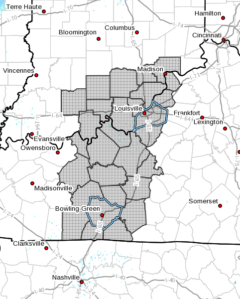
Orange-Washington-Scott-Jefferson-Dubois-Crawford-Perry-Harrison- Floyd-Clark-Hancock-Breckinridge-Meade-Ohio-Grayson-Hardin- Bullitt-Oldham-Trimble-Larue-Butler-Edmonson-Hart-Logan-Warren- Simpson-Allen-Barren- Including the cities of Paoli, Salem, Scottsburg, Madison, Jasper, English, Tell City, Corydon, New Albany, Jeffersonville, Lewisport, Hawesville, Hardinsburg, Brandenburg, Hartford, Leitchfield, Elizabethtown, Shepherdsville, Louisville, La Grange, Bedford, Milton, Hodgenville, Morgantown, Brownsville, Horse Cave, Russellville, Bowling Green, Franklin, Providence, Scottsville, and Glasgow 352 AM EST Sun Jan 7 2018 /252 AM CST Sun Jan 7 2018/ ...WINTER WEATHER ADVISORY IN EFFECT FROM 10 PM EST /9 PM CST/ THIS EVENING TO 1 PM EST /NOON CST/ MONDAY... * WHAT...Freezing rain, sleet, and snow expected. The ice and snow will result in difficult travel conditions, including during the morning commute on Monday. Total ice accumulations of up to one tenth of an inch are expected. Total snow and sleet accumulations of a few tenths of an inch expected. * WHERE...Portions of southern Indiana and central Kentucky. * WHEN...10 PM today to 1 PM Monday. PRECAUTIONARY/PREPAREDNESS ACTIONS... A Winter Weather Advisory means that periods of freezing rain, sleet, and snow will cause travel difficulties. Be prepared for slippery roads. Slow down and use caution while driving. The latest road conditions for the state you are calling from can be obtained by calling 5 1 1.
-
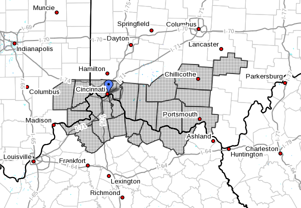
For the Cincinnati/NKY area Ripley-Dearborn-Ohio-Switzerland-Carroll-Gallatin-Boone-Kenton- Campbell-Owen-Grant-Pendleton-Bracken-Robertson-Mason-Lewis-Ross- Hocking-Hamilton-Clermont-Brown-Highland-Adams-Pike-Scioto- Including the cities of Batesville, Milan, Versailles, Lawrenceburg, Aurora, Rising Sun, Vevay, Carrollton, Warsaw, Florence, Burlington, Oakbrook, Covington, Erlanger, Independence, Newport, Alexandria, Owenton, Williamstown, Crittenden, Dry Ridge, Falmouth, Butler, Augusta, Brooksville, Mount Olivet, Maysville, Vanceburg, Tollesboro, Chillicothe, Logan, Cincinnati, Milford, Georgetown, Mount Orab, Hillsboro, Greenfield, West Union, Peebles, Waverly, Piketon, Portsmouth, and Wheelersburg 357 AM EST Sun Jan 7 2018 ...WINTER WEATHER ADVISORY IN EFFECT FROM MIDNIGHT TONIGHT TO 2 PM EST MONDAY... * WHAT...Mixed precipitation expected. The ice will result in difficult travel conditions, including during the morning commute on Monday. Total ice accumulations of around one tenth of an inch are expected. Little if any snow accumulation is expected. * WHERE...Portions of Southeast Indiana, Northeast and Northern Kentucky and Central and Southwest Ohio. * WHEN...From midnight tonight to 2 PM EST Monday. PRECAUTIONARY/PREPAREDNESS ACTIONS... A Winter Weather Advisory means that periods of snow, sleet or freezing rain will cause travel difficulties. Be prepared for slippery roads and limited visibilities, and use caution while driving.
-
Saturday evening update. My confidence is growing that we are looking for at a freezing rain than a snow event. The commute Monday morning could be a difficult one. As of this evening, any snow accumulations look to be light and mainly confined to above the I-64 corridor. The modeling data shows that freezing rain could fall across most of Kentucky Sunday night into Monday morning. High temps on Monday look to range from the mid-30s to the low to mid-40s. Here are the latest modeling data. The Candian and NAM are pretty close. These maps are showing possible accumulations through Monday before the wintry precipitation turns over to a cold rain, NAM Freezing rain accumulations Snow Accumulations The Canadian Model Freezing rain Snow The GFS is showing a little more snow Freezing Rain Snow We'll just have to wait and see which one is the closest. I fully expect Winter Weather Advisories to be issued by Sunday morning. I'll update in the morning.
-
Thanks for reminding me. I completely forgot about it.
-
Saturday morning update. The precipitation is expected to begin late Sunday evening as a wintry mix of rain, freezing rain, sleet, and snow. Sunday night into Monday morning a wintry mix could be ongoing in northern Kentucky. Parts of south-central Kentucky should transition to a cold rain as the temperature warms up above freezing. The precipitation should come to an end late Monday night until early Tuesday morning but some freezing rain may occur as it ends. The greatest ice and snow accumulations look to be north of the Bluegrass Parkways. Remember we could see more snow than ice if colder temperatures occur. Here are a couple of maps to show possible snow and ice accumulations from the NAM model as of this morning. I'll update later today. Everyone can also follow our Twitter page for information throughout the day.
-
Just to let everyone know what may be in store for some late Sunday evening into the day on Monday. We could be looking at a mixed bag of winter precipitation. With the persistent very cold weather we have been having the ground is already very cold. Freezing rain looks to be the main concern as the precipitation moves through Kentucky before the temps rise above freezing on Monday. Little or no snow accumulations are expected at this time. Travel late Sunday into the morning hours on Monday could be problematic for some. Here is the NAM simulated radar from late Sunday night into Monday afternoon. This is the freezing rain accumulation map. An update will come in the morning unless information warrants it.
-
Just a quick note from the briefing. Those mainly north of I-64 could be looking at snow and ice Sunday evening into the day on Monday before changing over to all rain. South of that people are looking at everything from snow, ice and rain. Along the Tennessee border some ice but mainly rain. I'll post an update later today.
-
I just received a text from the same NWS-Louisville about a conference call at 1:30 this afternoon. I will post an update as soon as possible afterwards.
-
I received the following in an email from the National Weather Service Office out of Louisville this morning. I will update on this later today. Good morning, The potential remains for wintry precipitation Sunday into Monday. Thinking has not changed much with this update except that we may have a bit later onset of precipitation Sunday early evening instead of Sunday afternoon. All winter precipitation modes (rain, freezing rain, snow, sleet) remain on the table for Sunday night into Monday morning before transitioning to all rain Monday. This could lead to some travel issues during this time. Confidence in precipitation type remains on the lower side at this time and the forecast will continue to be refined over the coming days.
-
Updates also will come through our Twitter page.
-
Wind Chill Advisory area has been expanded ..WIND CHILL ADVISORY TONIGHT/FRIDAY MORNING... .The combination of cold temperatures down around zero, and northwest surface winds between 5 and 10 mph will yield wind chill values between 8 below zero and 12 below zero tonight and Friday morning. Wind chill values should improve by mid to late morning on Friday. INZ077>079-092-KYZ031>037-040>042-049-050500- /O.NEW.KLMK.WC.Y.0001.180105T0200Z-180105T1600Z/ Washington-Scott-Jefferson-Clark-Oldham-Trimble-Henry-Shelby- Franklin-Harrison-Woodford-Fayette-Bourbon- Including the cities of Salem, Scottsburg, Madison, Jeffersonville, La Grange, Bedford, Milton, New Castle, Shelbyville, Frankfort, Georgetown, Cynthiana, Versailles, Lexington, Paris, and Winchester 328 PM EST Thu Jan 4 2018 ...WIND CHILL ADVISORY IN EFFECT FROM 9 PM THIS EVENING TO 11 AM EST FRIDAY... * WHAT...Wind chill values between 8 below zero and 12 below zero will cause frostbite in as little as 30 minutes to exposed skin. * WHERE...Portions of southern Indiana and north central Kentucky. * WHEN....Tonight and Friday morning. * ADDITIONAL DETAILS...Dress warmly and keep a winter travel kit in your car. Bring your pets indoors if they do not have adequate shelter outdoors. PRECAUTIONARY/PREPAREDNESS ACTIONS... A Wind Chill Advisory means that cold air and the wind will combine to create low wind chills. Frost bite and hypothermia can occur if precautions are not taken. Make sure you wear a hat and gloves.
-
7 AM HRRR Temp and wind chill maps for Friday Morning 1/8/18