.png.ffa34568722b20f38e3c3ecfcb9a2cd2.png)

.jpg.67ca52c6df25163f3af009c91bda1717.jpg)
nWo
-
Posts
25,586 -
Joined
-
Last visited
-
Days Won
2
Everything posted by nWo
-
It is based on an atomic clock and is the worlds official reference for time. UTC time is used by planes, ships at sea and weather satellites. There are no time zones and it is the same time no matter where you are in the world. For instance 0000 UTC (8 pm 12 hour clock) starts a new day. So at 0000 UTC it turned into Thursday. Where in a 12 hour clock the new day starts at midnight.
-
:thumb:
-
One thing about the time stamp. That is not military time but UTC time. It is different.
-
I like the way #1 looks but I'm not really a fan of the speed but that's just me.
-
That's what I was thinking too.
-
Ok this one shows the possible rain from Friday morning till Saturday afternoon. Hopefully these will keep working. The file size has been the main problem.
-
Which animation speed does everyone like? #1 or #2.
-
-
This is just a test. I'm trying to figure out how to post an animation of what the models show for the temps for Thursday.
-

-
I wish I knew so I could watch the game. Yes he graduated from there in 2008 and played on the basketball team.
-
I'm in
-
Union College defeated Cornerstone(Mich) tonight 72-69 to win the NAIA Division II National Championship. DakStats WebSync
-
Nope not over yet. Looks like another chance of snow and temps in the mid teens to close out the month of March. This is around the last weekend of the month.
-
You're welcome my friend.
-
I'll be watching it for you. Be safe and stay warm.
-
right now temps in the low to mid 30s. Little or no chance of precipitation. Temps look to in the upper 40s to low 50s in Winchester by Saturday afternoon.
-
I didn't go but one of my coworkers took his daughter. She got to kiss the Nature Boy on the cheek!
-
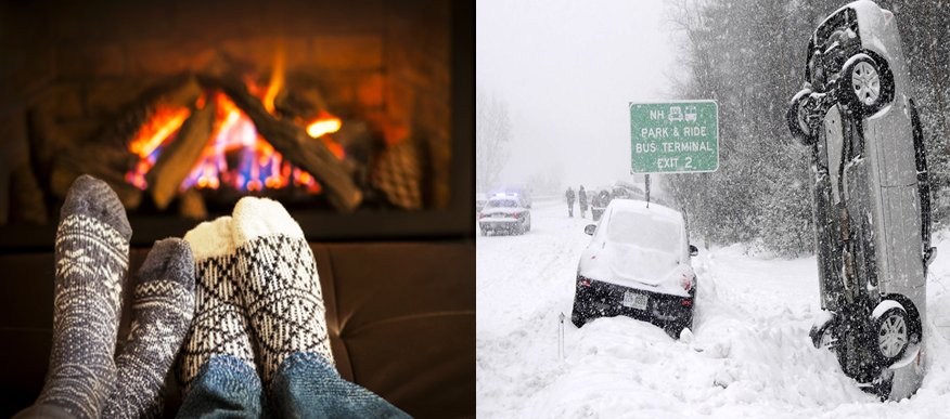
Stay off the roads when conditions become hazardous. One picture is #WeatherReady and the other is not. Avoid the danger...and the misery. from NOAA WRN Ambassadors
-
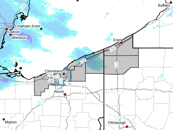
@gold sunrise You are now under a Winter Storm Warning Lorain-Cuyahoga-Lake-Geauga-Ashtabula Inland-Ashtabula Lakeshore- Northern Erie-Southern Erie-Crawford- Including the cities of Lorain, Cleveland, Mentor, Chardon, Jefferson, Ashtabula, Erie, Edinboro, and Meadville 1046 PM EDT Sun Mar 12 2017 ...WINTER STORM WARNING IN EFFECT FROM 5 PM MONDAY TO 8 PM EDT WEDNESDAY... The National Weather Service in Cleveland has issued a Winter Storm Warning for heavy snow, which is in effect from 5 PM Monday to 8 PM EDT Wednesday. The Winter Storm Watch is no longer in effect. * Accumulations...6 to 10 inches of snow from Monday evening through Tuesday afternoon, with additional lake effect snow continuing at times through Wednesday. * Timing...Snow will begin Monday afternoon and increase in intensity Monday night into Tuesday morning. Occasional snow showers will continue Tuesday night and Wednesday. * Impacts...Difficult driving conditions with reduced visibility and snow covered roads. * Winds...Northeast winds 10 to 20 mph Monday night becoming north 15 to 25 mph with gusts up to 35 mph on Tuesday. * Temperatures...In the 20s. PRECAUTIONARY/PREPAREDNESS ACTIONS... A Winter Storm Warning for heavy snow is issued when severe winter weather conditions are expected or occurring. Significant amounts of snow are forecast that will make travel dangerous. Only travel in an emergency. If you must travel...keep an extra flashlight...food...and water in your vehicle in case of an emergency.
-
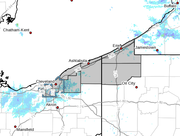
@gold sunrise There is now a Winter Storm Watch out for Cleveland starting Monday afternoon into Wednesday. Any where from 6-10 inches are expected. URGENT - WINTER WEATHER MESSAGE National Weather Service Cleveland OH 404 AM EDT Sun Mar 12 2017 ...HEAVY SNOW EXPECTED MONDAY EVENING THROUGH WEDNESDAY... .A complex winter storm will affect the Snowbelt of northeast OH and northwest PA early this week. Low pressure will track through the Ohio Valley on Monday bringing widespread snow to the area Monday night into Tuesday. Snowfall amounts across this area will be enhanced due to additional moisture from Lake Erie. The snow will then transition to lake-effect Tuesday night into Wednesday as northerly flow continues across the area. OHZ011>014-089-PAZ001>003-121615- /O.NEW.KCLE.WS.A.0002.170313T2100Z-170316T0000Z/ Cuyahoga-Lake-Geauga-Ashtabula Inland-Ashtabula Lakeshore- Northern Erie-Southern Erie-Crawford- Including the cities of Cleveland, Mentor, Chardon, Jefferson, Ashtabula, Erie, Edinboro, and Meadville 404 AM EDT Sun Mar 12 2017 ...WINTER STORM WATCH IN EFFECT FROM MONDAY AFTERNOON THROUGH WEDNESDAY EVENING... The National Weather Service in Cleveland has issued a Winter Storm Watch, which is in effect from Monday afternoon through Wednesday evening. * Accumulations/Timing...6 to 10 inches of snow late Monday afternoon through Tuesday afternoon, with additional lake- effect snow possible Tuesday night through Wednesday. * IMPACTS...Heavy snow could produce very difficult driving conditions with very poor visibility and snow covered roads. * Winds...North 10 to 20 mph with gusts up to 30 mph. * Visibilities...As low as a quarter of a mile at times. * Temperatures...In the 20s. PRECAUTIONARY/PREPAREDNESS ACTIONS... A Winter Storm Watch is issued when there is a potential for significant snow...sleet...or ice accumulations that may impact travel. Continue to monitor the latest forecast and prepare for possible warnings.
-
It will mainly depend on timing. What I just went over, GFS is showing the temps will be above freezing until early Tuesday morning. Temps look to fall during the day on Tuesday into the low to mid 20s by Tuesday evening. For now the moisture looks to move out ahead of the temperature drop. Maybe a mix and very light if any accumulations as the temperature drops before the precipitation moves out completely. The NAM is showing that the below freezing temps won't move in until Tuesday evening so timing will be every thing. Those is SE and EKY should pay attention to the weather at this time. If the predicted system shifts westward members in that area could see some nice accumulations.
-
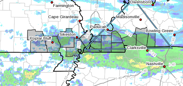
709 AM CST Sat Mar 11 2017 ...WINTER WEATHER ADVISORY IN EFFECT UNTIL 11 AM CST THIS MORNING... THE NATIONAL WEATHER SERVICE IN Paducah HAS ISSUED a Winter Weather Advisory...WHICH IS IN EFFECT until 11 AM CST this morning. * TIMING: Mainly early today. * MAIN IMPACT: Most snow accumulations up to an inch or so will be on grassy areas, trees and vehicles. However, where the snow comes down the hardest, some slushy accumulations may occur on roadways, especially on bridges and overpasses. PRECAUTIONARY/PREPAREDNESS ACTIONS... A winter weather advisory means that periods of snow...sleet...or freezing rain may cause travel difficulties. Be prepared for slippery roads and limited visibilities...and use caution while driving.
-
Here's my updated look at the snow for Saturday into Sunday. It now appears that most of the snow has moved even further south with the heaviest possible accumulations in WKY. From the Louie B Nunn PKWY southward dusting to 1" of accumulations. Western Kentucky could see anywhere from 2-4". This looks to be west of The Land Between the Lakes area. I'll be back in a few with a new thread for the possible snow for early next week.
-
First look at possible accumulations for Saturday. I'm thinking from a dusting to about 1" mainly south of I-64. I will update later today. Also give my first thoughts on the second system that looks to come through early next week.
.thumb.jpg.d475a671bdc851f901dea439c04b8f9d.jpg)