.png.ffa34568722b20f38e3c3ecfcb9a2cd2.png)

.jpg.dff87640c6ed93f4bdf8eebdf96f5dec.jpg)
nWo
-
Posts
25,628 -
Joined
-
Last visited
-
Days Won
5
Everything posted by nWo
-
Quick update. The Storm Prediction Center now has the entire state of Kentucky in a Slight Risk Area for strong to severe storms for Sunday. I will post a more detailed update later this evening.

-
Just did some checking on the possibility of any tornado activity for Sunday afternoon into the evening hours. Two areas that may see some possible tornadic activity are parts of WKY and NKY. The threat is low but it is still there for both of these locations as the simulated map shows below. Timing is between 2-8 pm EDT.
-
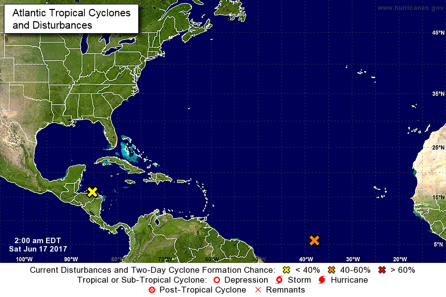
I'm keeping an eye on two disturbances that may develop into Cyclonic Formation in the next 5 days. One located near Honduras and the other one 1600 miles east-southeast of the Windward Islands. Will update when information warrants it.
-
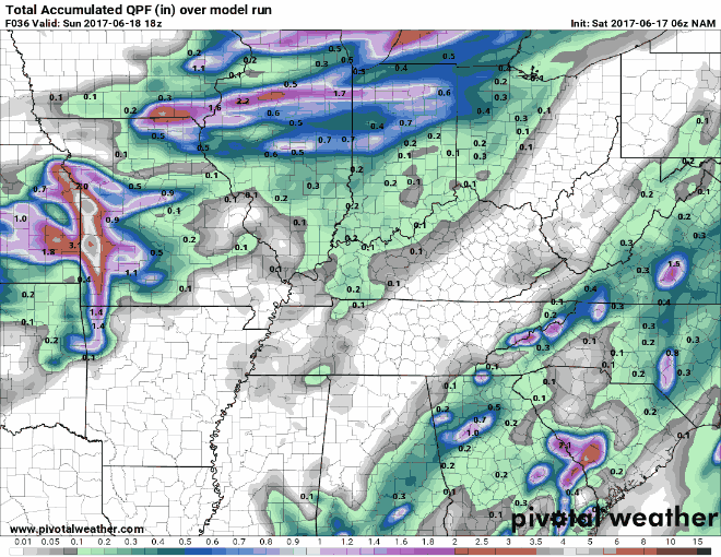
Here's my latest outlook for Sunday. Most of Kentucky is in a Slight Risk Area for strong to severe storms Sunday afternoon into the evening hours. Isolated to scattered thunderstorms, some of which will be severe and mainly accompanied by the risk for potentially damaging wind gusts, are possible. Also there could be some isolated hail with the stronger storms. Also the Weather Prediction Center has parts of Kentucky in a Slight Risk Area for flash flooding. Some areas could receive 1-2" of rain in a very short period of time. This could induce flash flooding in those areas. Everyone can see in the simulated accumulation map that the rainfall totals will rise rapidly under the stronger storms. For now the timing looks to be between 2-5 pm EDT especially for some along the Tennessee boarder around the Bowling Green area. Also those in the Louisville to NKY area should be ready for the potential for flash flooding. Simulated Radar Severe Potential Maps
-
You're welcome my friend and Amen!
-
Strong storms, mainly accompanied by the risk for potentially damaging wind gusts, are possible Sunday afternoon and evening. The potential is there for some heavy rainfall totals. The Weather Prediction Center has parts of Kentucky in a Slight Risk Area for excessive rainfall mainly that looks to fall Sunday afternoon into the evening hours. Some parts of Kentucky are looking at a possible 2-3" of rain mainly east of I-75. I will update in the morning.
-
Yep! very good news!!
-
I didn't know when you were returning home but if you are still in Cleveland watch for some showers and thunderstorms today. On Saturday Cleveland is in an Marginal Risk Area for strong to severe storms.
-
The stormy pattern continues today with the chance of scattered showers and storms. Some of which could go severe. The SPC has parts of Kentucky in a Marginal Risk Area for isolated strong to severe storms. The primary threats with these storms will be damaging winds gusts and hail. Once again we will see dew points across the state from the upper 60s to low 70s. This will provide fuel for the storms to put down some heavy down pours once again for today. Not everyone will see these storms but as it was yesterday today's storms could go severe quite quickly with little or nor notifications. This patter looks to continue on Thursday. The Storm Prediction Center has most of Kentucky in a Marginal Risk Area for strong to severe storms. A slight part of southern WKY is in a slightly higher risk for strong to severe storms because it is in Slight Risk Area. Everyone should be weather aware for later today. This is the simulated radar from around 2-6 pm EDT Thursday
-
You're welcome my friend glad you both made it safely.
-
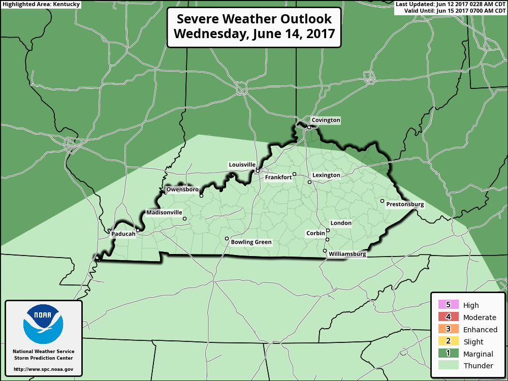
The Storm Prediction Center has parts of Kentucky in a Marginal Risk area for strong to severe storms during the day on Wednesday. These storms are expected to develop by late morning/early afternoon. As of now the development looks to be loosely organized with the potential for some cells to produce microbursts with strong surface winds. Localized Damaging winds and hail will be possible in the stronger storms. This simulated radar is from 5 am to 5 pm EDT. It shows the possible storms matching closely with what the SPC has, for now, for Wednesday. Those in WKY should be on the look out during the night time hours. There appears to be a line of storms that may reach western Kentucky after the 8 pm EDT hours. This simulated radar is from 8 pm to 5 am EDT. I will update in the morning.
-
It sure was a downpour. After it slacked off a little bit I walked out in it to cool off. Before the rain came the humidity was terrible in the factory where I work.
-
severe thunderstorm warning for the Cincinnati area.
-
Look for temps in the mid to upper 80s Friday afternoon and falling into the low to mid 70s by evening. Showers may move in during the evening hours.
-
Showers and thunderstorms are possible this afternoon. These could be stronger and more widespread than yesterday's coverage. Some storms could put down some localized heavy rain totals. As much as 1-2" could be possible this afternoon under the stronger storms. While some could be strong severe weather is not expected at this time. Please note even though severe weather is not expected with temps in the mid to upper 80s and dew points in the upper 60s to low 70s I wouldn't be surprised is some of the local storms go severe quite quickly.
-
Look for scattered showers and possible thunderstorms from around NKY to central Ohio from between 8 am to 2 pm EDT. A Marginal Risk of strong to severe storms in and around the Cleveland area late afternoon into the evening hours. Afternoon highs in the mid to upper 80s. I got you covered with a warning area for Cleveland.
-
For the the first time the SPC has parts of Kentucky in a Marginal Risk Area for strong to severe storms Wednesday. For now this is mainly for northern and northeastern Kentucky.
-
Really too early to say definitely but Saturday afternoon and evening could see some strong to severe storms fire up. Then they could fire up again Sunday afternoon and evening. This is what the GFS model was showing this morning. I'll post an update for this weekend later.
-
Monday morning update. There looks to be a chance of scattered thunderstorms each afternoon this week. Some of which could be strong. Everyone won't see these storms but for those along the Ohio River they should be on the look out. These pop up storms could go severe quite quickly without much warning. I'm still seeing the chance for the coverage of these storms to increase by the end of the work week. This weekend's GFS model is showing some interesting possible weather that I will keep a close eye on. I will update later today. Have a blessed Monday
-
That should have been I-65
-
The weather has been absolutely wonderful that past couple of days. Things look to change starting early this week. Showers and thunderstorms will be possible starting Monday evening and continue each day. As of now the best chance to see strong to severe storms looks to be Wednesday afternoon into the night time hours. The strongest storms looks to be west of I-65. While the strongest looks to be confined west of the I-65 corridor, the rest of us are also looking at showers and storms but not as strong. High temps look to average from the mid to upper 80s and the lows in low to mid 60s. I will update as we get closer. Have a blessed day.
-
Thank you my friend.
-
Thanks to everyone. I love all of the weather birthday pictures!!
-
You are so right. Weather couldn't be better. Thanks
-
I'm in.
.thumb.jpg.dc448957daf4ddf2823660190e844abb.jpg)