

nWo
BGP Meteorologist
-
Joined
-
Last visited
Everything posted by nWo
-
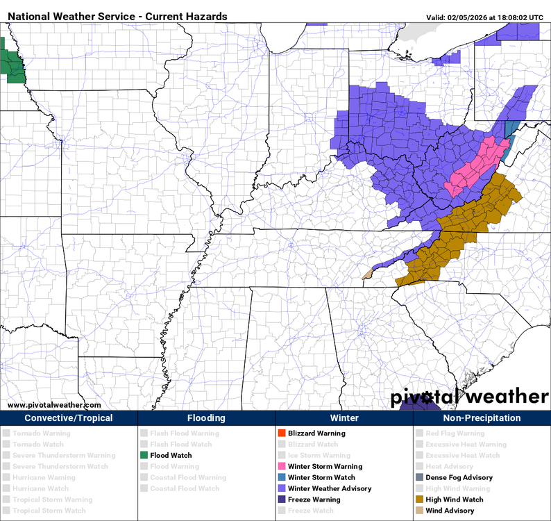
URGENT - WINTER WEATHER MESSAGE National Weather Service Wilmington OH 1228 PM EST Thu Feb 5 2026 INZ050-058-059-066-073>075-080-KYZ089>100-OHZ026-034-035-042>046- 051>056-060>065-070>074-077>082-088-060130- /O.NEW.KILN.WW.Y.0005.260206T1100Z-260206T2300Z/ Wayne-Fayette-Union-Franklin-Ripley-Dearborn-Ohio-Switzerland- Carroll-Gallatin-Boone-Kenton-Campbell-Owen-Grant-Pendleton- Bracken-Robertson-Mason-Lewis-Hardin-Mercer-Auglaize-Darke-Shelby- Logan-Union-Delaware-Miami-Champaign-Clark-Madison-Franklin- Licking-Preble-Montgomery-Greene-Fayette-Pickaway-Fairfield- Butler-Warren-Clinton-Ross-Hocking-Hamilton-Clermont-Brown- Highland-Adams-Pike-Scioto- Including the cities of Milan, Tollesboro, Coldwater, Fairborn, Bright, Logan, Rising Sun, Middletown, Connersville, Landen, Summerside, Pickerington, Mount Repose, Greendale, Warsaw, Plain City, Ripley, Osgood, Burlington, Mulberry, Versailles, Eaton, West Union, Aberdeen, Winchester, Milford, Georgetown, Blanchester, Piqua, Butler, Beavercreek, Ada, Springboro, New Bremen, Hidden Valley, Minster, Vevay, Newport, Pike Lake, Batesville, Greenville, Erlanger, Richmond, Dry Ridge, Delaware, Mount Orab, Wheelersburg, Camden, Mason, Lawrenceburg, Augusta, Wilmington, Piketon, Head Of Grassy, St. Marys, Mount Carmel, Covington, Seaman, Chillicothe, Crittenden, Dayton, Springfield, Bellefontaine, Wapakoneta, West College Corner, Downtown Dayton, Bellevue, West Jefferson, Peebles, Day Heights, Camp Dix, Newark, Hamilton, Dillsboro, Alexandria, Oxford, Oakbrook, Mount Olivet, Florence, Tipp City, Troy, Independence, Brooksville, Hillsboro, Waverly, London, Vanceburg, Celina, Aurora, Lebanon, Xenia, Downtown Cincinnati, Greenfield, Kettering, Portsmouth, Liberty, Circleville, Sidney, Withamsville, Owenton, Maysville, Urbana, Carrollton, Fort Thomas, Highland Heights, Fairfield, Lancaster, Marysville, Williamstown, Falmouth, Washington Court House, Brookville, Franklin, Manchester, Downtown Columbus, and Kenton 1228 PM EST Thu Feb 5 2026 ...WINTER WEATHER ADVISORY IN EFFECT FROM 6 AM TO 6 PM EST FRIDAY... * WHAT...Snow expected. Total snow accumulations up to two inches with locally higher amounts. * WHERE...Portions of east central and southeast Indiana, northeast and northern Kentucky, and central, south central, southwest, and west central Ohio. * WHEN...From 6 AM to 6 PM EST Friday. * IMPACTS...Plan on slippery road conditions. The hazardous conditions could impact the Friday morning and evening commutes. PRECAUTIONARY/PREPAREDNESS ACTIONS... Slow down and use caution while traveling. In Indiana, visit 511in.org or call 1-800-261-7623 for the latest road information. In Kentucky, visit goky.ky.gov for the latest road information. In Ohio, visit ohgo.com for the latest road information.
-
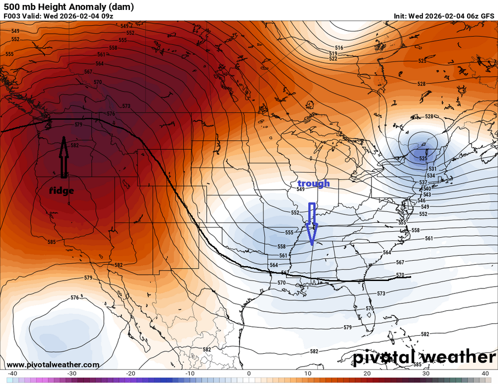
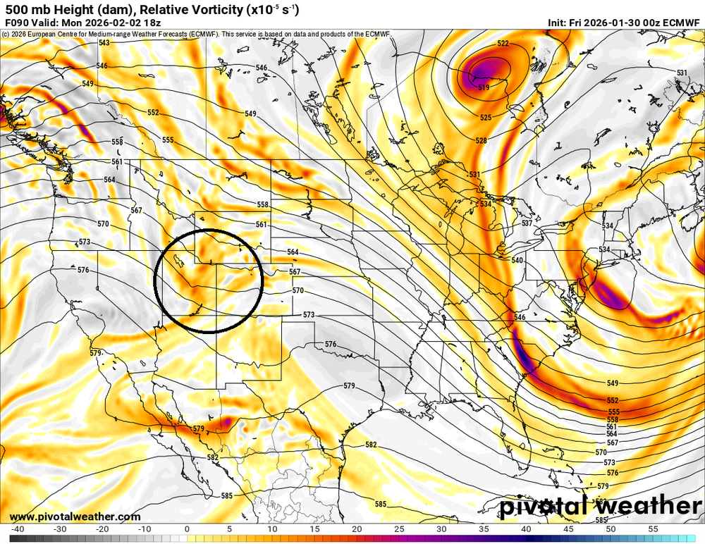
As I've posted in the past, we have been locked into a typical La Niña pattern. A ridge in the west and a trough in the east. This pattern may start to break down next week. If it does, then we will need to watch any system that could form and travel across the southern part of the country. The red circle, this energy source, is worth observing. A low-pressure system might develop and get stronger if it keeps moving across the southern United States. In the event that this occurs, the low may access and attract some warm gulf moisture. It is also necessary to keep an eye on the 540 line. This could make the difference between some people receiving rain and others receiving freezing rain and snow. The 540 line is the freezing line; north of it means snow. South of it could mean freezing rain or just rain. Although it is too far in the future to make any firm predictions, the time frame surrounding Valentine's Day weekend needs to be closely monitored.
.thumb.png.7d758681c4d634acf17414752d3bdae5.png)
-
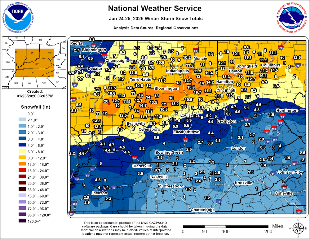
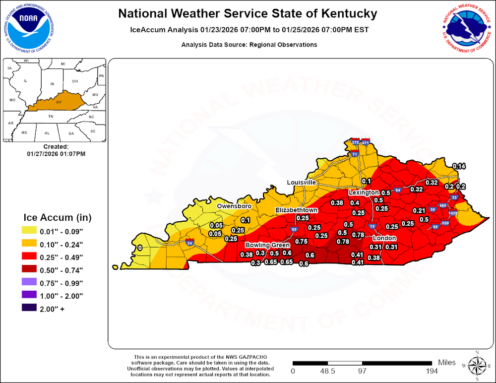
Official totals
-
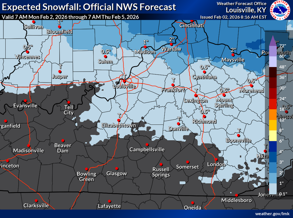
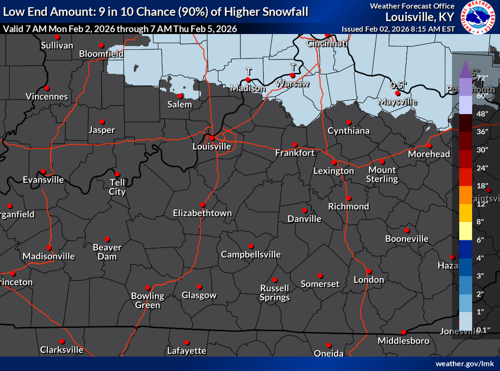
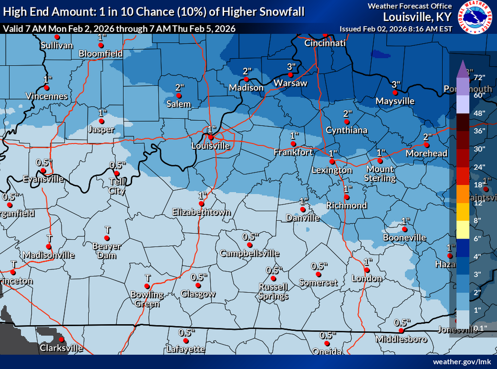
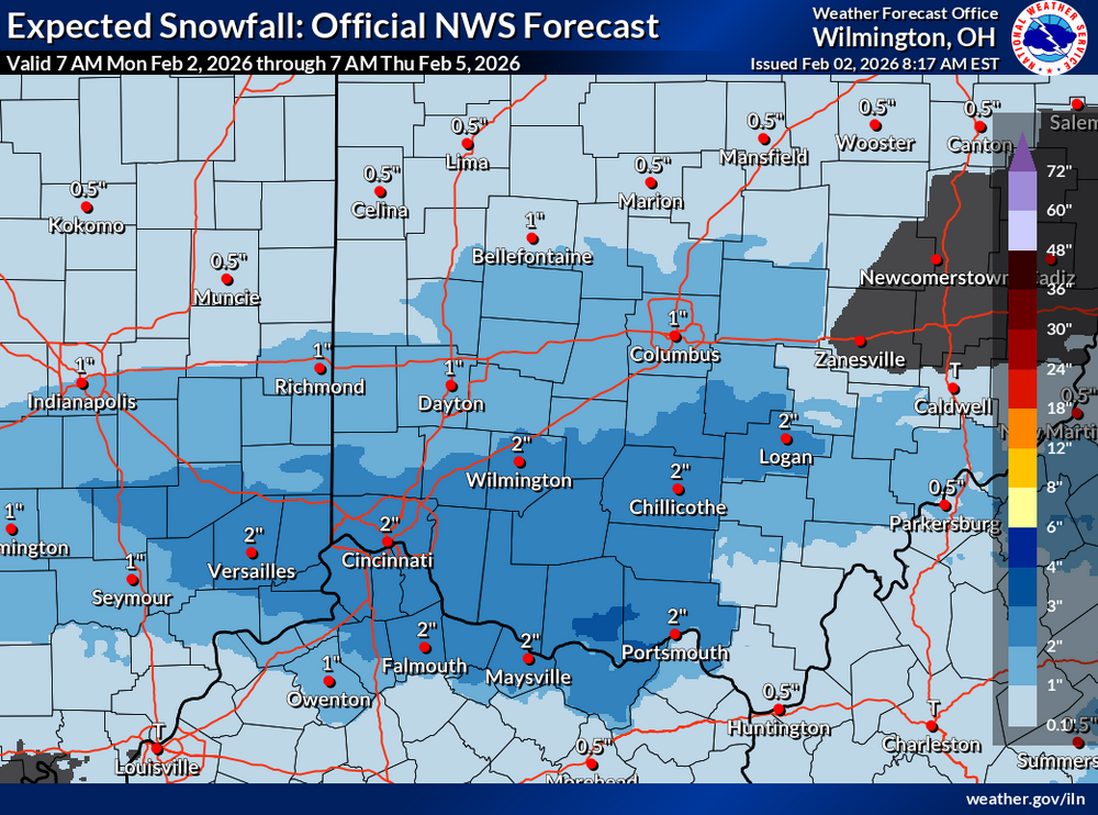
The coverage area of this winter weather advisory has just been expanded URGENT - WINTER WEATHER MESSAGE National Weather Service Louisville KY 112 PM EST Mon Feb 2 2026 INZ077>079-092-KYZ031>033-036-037-042-043-031000- /O.NEW.KLMK.WW.Y.0004.260203T1500Z-260204T0500Z/ Washington IN-Scott IN-Jefferson IN-Clark IN-Oldham-Trimble-Henry- Scott KY-Harrison KY-Bourbon-Nicholas- Including the cities of Georgetown, Carlisle, Jeffersonville, Cynthiana, Scottsburg, Bedford, Paris, La Grange, New Castle, Salem, Milton, and Madison 112 PM EST Mon Feb 2 2026 ...WINTER WEATHER ADVISORY IN EFFECT FROM 10 AM TUESDAY TO MIDNIGHT EST TUESDAY NIGHT... * WHAT...Snow expected. Total snow accumulations 1 to 2 inches of slushy, wet snow. The Tuesday afternoon and evening commutes will be affected. * WHERE...Portions of south central Indiana and east central and north central Kentucky. * WHEN...From 10 AM Tuesday to midnight EST Tuesday Night. * IMPACTS...Plan on slippery road conditions. The hazardous conditions could impact the Tuesday evening commute. PRECAUTIONARY/PREPAREDNESS ACTIONS... Slow down and use caution while traveling. In Indiana, for Indiana Road Conditions please visit http://511in.org In Kentucky, for Kentucky Road Conditions please visit http://goky.ky.gov Be prepared for slippery roads. Slow down and use caution while driving. If you are going outside, watch your first few steps taken on stairs, sidewalks, and driveways. These surfaces could be icy and slippery, increasing your risk of a fall and injury.This time it looks like here in Richmond we may get all rain. It could change to some light snow on the backside of the low as it moves away from Kentucky.URGENT - WINTER WEATHER MESSAGE National Weather Service Wilmington OH 1249 PM EST Mon Feb 2 2026 INZ066-073>075-080-KYZ089>100-OHZ070>074-077>082-088-030600- /O.NEW.KILN.WW.Y.0004.260203T1200Z-260204T0300Z/ Franklin-Ripley-Dearborn-Ohio-Switzerland-Carroll-Gallatin-Boone- Kenton-Campbell-Owen-Grant-Pendleton-Bracken-Robertson-Mason- Lewis-Butler-Warren-Clinton-Ross-Hocking-Hamilton-Clermont-Brown- Highland-Adams-Pike-Scioto- Including the cities of Versailles, Logan, Hillsboro, Camp Dix, Mason, Pike Lake, Highland Heights, Oakbrook, Bellevue, Day Heights, Covington, Head Of Grassy, Batesville, Franklin, Hamilton, Carrollton, Dry Ridge, Chillicothe, Milford, Georgetown, Fairfield, Vevay, Portsmouth, Aberdeen, Dayton, Fort Thomas, Falmouth, Mount Olivet, Waverly, Wilmington, Bright, Springboro, Maysville, Newport, Independence, Erlanger, Butler, Rising Sun, Brooksville, Alexandria, Peebles, Downtown Cincinnati, Vanceburg, West Union, Seaman, Aurora, Landen, Williamstown, Hidden Valley, Crittenden, Mulberry, Wheelersburg, Burlington, Mount Repose, Brookville, Manchester, Osgood, Middletown, Greenfield, Mount Orab, Ripley, Florence, Owenton, Lebanon, Summerside, Lawrenceburg, Mount Carmel, Winchester, Oxford, Withamsville, Blanchester, Piketon, Greendale, Warsaw, Dillsboro, Augusta, Milan, and Tollesboro 1249 PM EST Mon Feb 2 2026 ...WINTER WEATHER ADVISORY IN EFFECT FROM 7 AM TO 10 PM EST TUESDAY... * WHAT...Snow expected. Total snow accumulations between 1 and 3 inches, with locally higher amounts. * WHERE...Portions of southeast Indiana, northeast and northern Kentucky, and central, south central, and southwest Ohio. * WHEN...From 7 AM to 10 PM EST Tuesday. * IMPACTS...Plan on slippery road conditions. The hazardous conditions could impact the Tuesday morning and evening commutes. PRECAUTIONARY/PREPAREDNESS ACTIONS... Slow down and use caution while traveling. In Indiana, visit 511in.org or call 1-800-261-7623 for the latest road information. In Kentucky, visit goky.ky.gov for the latest road information. In Ohio, visit ohgo.com for the latest road information.Low-Pressure System Moving Through Tuesday A low-pressure system will bring a mix of snow and rain to the region from Tuesday into Tuesday evening. Snow will be possible in southern/central Indiana early Tuesday morning, transitioning to rain/snow by the afternoon. Uncertainty remains for the rain/snow dividing line, especially in north-central Kentucky and southern Indiana. As of now, it appears that the heaviest snow accumulations will be north of I-64. Light snow accumulations are possible in areas seeing extended snowfall. Stay tuned for updates! NWS-Wilmington, OH NWS-Louisville, KY
.thumb.png.be764f50093f8b5933ec903aab3d9ce2.png)
.thumb.png.c4d57ad15b7913af30595bcb796f0d8d.png)
 PUNXSUTAWNEY, Pa. — Punxsutawney Phil is said to be predicting six more weeks of wintry weather after he saw his shadow Monday. https://www.npr.org/2026/02/02/nx-s1-5696304/groundhog-day-punxsutawney-phil-forecast-winter-length @theguru
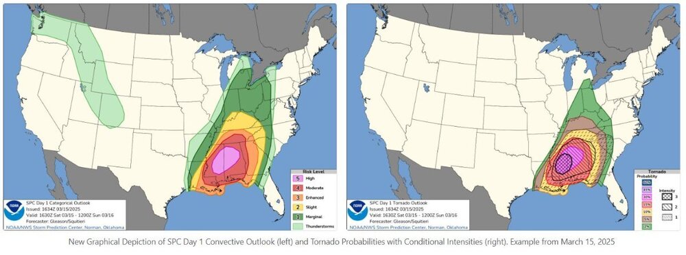
 BluegrassPreps Weather Update: Kentucky Weather Outlook (Feb 7-15, 2026). Feb 7-11, 2026: Eastern Kentucky: Expect cold temps, with highs in the 30s-40s and lows in the 20s. Western Kentucky: Light snow or rain possible, with 1-3 inches of accumulation in some areas. Feb 9-15, 2026: Western Kentucky: A slight warm-up is coming with highs in the 50s and lows in the 30s. Eastern Kentucky: Still cold, with highs in the 30s-40s and light snow showers likely. Western areas could see 1-2 inches of snow or a mix of rain and snow. Stay ahead of the storm and keep your plans updated with BluegrassPreps!The new approach differs from the previous one in that the high-risk area would simply remain high-risk. You would have to say that there is an equal chance of a powerful long-track tornado occurring throughout the entire region. The new method will indicate which area of the high-risk area is most likely to experience strong tornadoes. They will therefore attempt to identify the area that has the best chance of witnessing a long-track strong tornado, even though there is a large area of high risk.
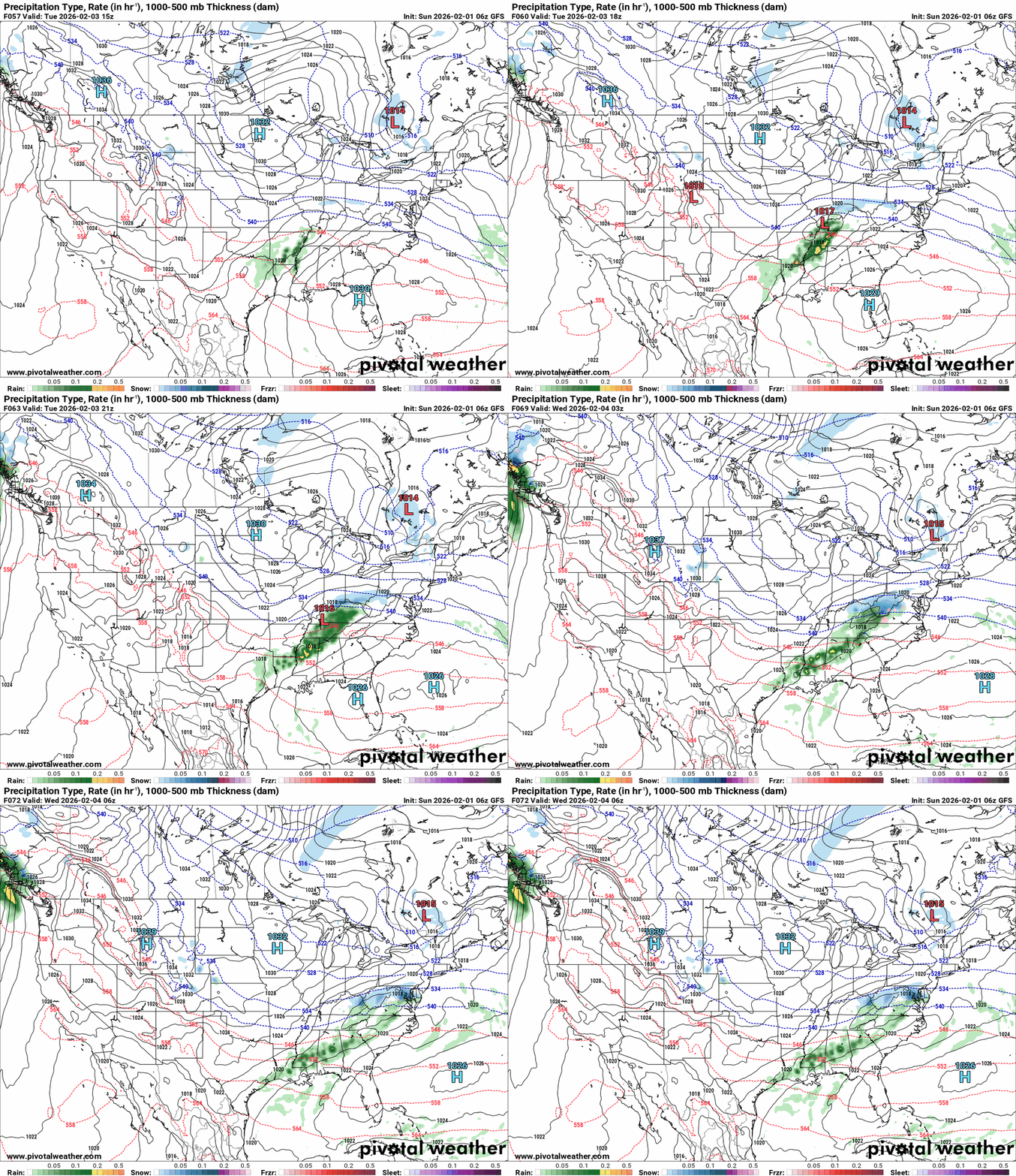
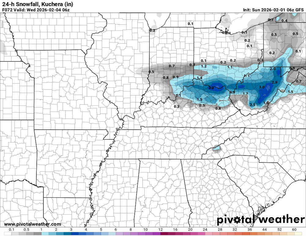
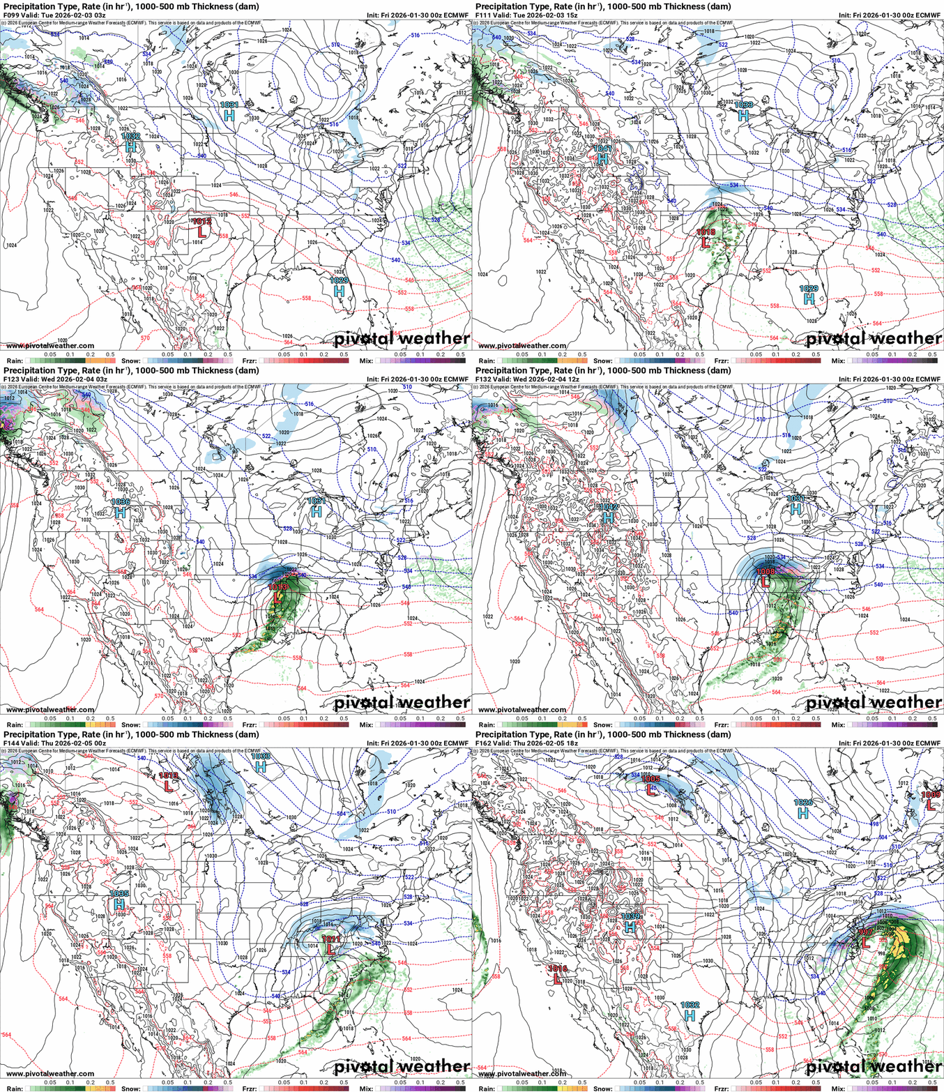
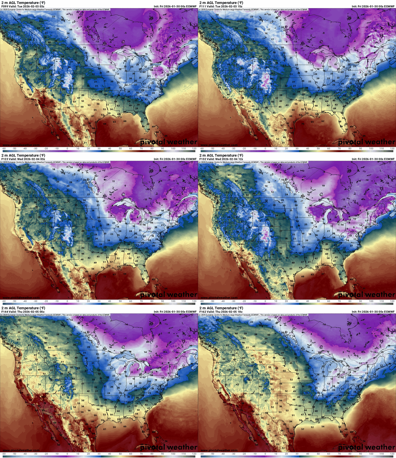
 Regarding the system that will impact our region from Tuesday night until early Wednesday morning, both the GFS and the Euro are in agreement. The GFS may have the storm linger in Kentucky a bit longer than the Euro, but that's the only difference I've noticed. For now, as I posted in my original post. I think most of the possible snow accumulations will be from around I-64 northward.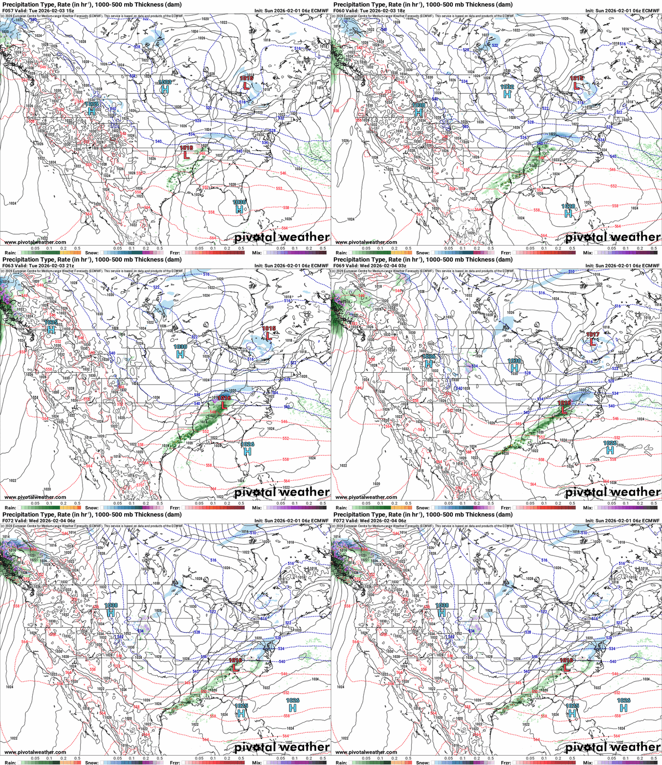
.thumb.png.3faf1bef2ddedc9b471803df209921c6.png)
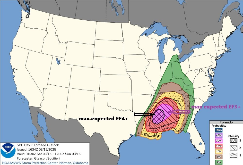
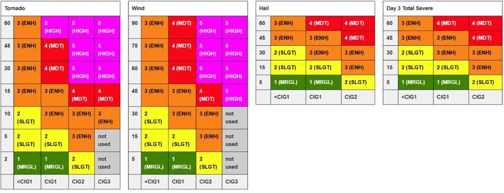
 This is how I read the new outlook. For example, if you are in an area with a 15% chance of a tornado and the SPC gives a conditional intensity group of 1 (black arrow). Your area could see a possible tornado max expected of EF-2+. So if the cig increases the max expected strength of the tornado, if one forms, it increases. I'm using a tornado as an example to try to explain this as I understand it. The same goes for wind and hail.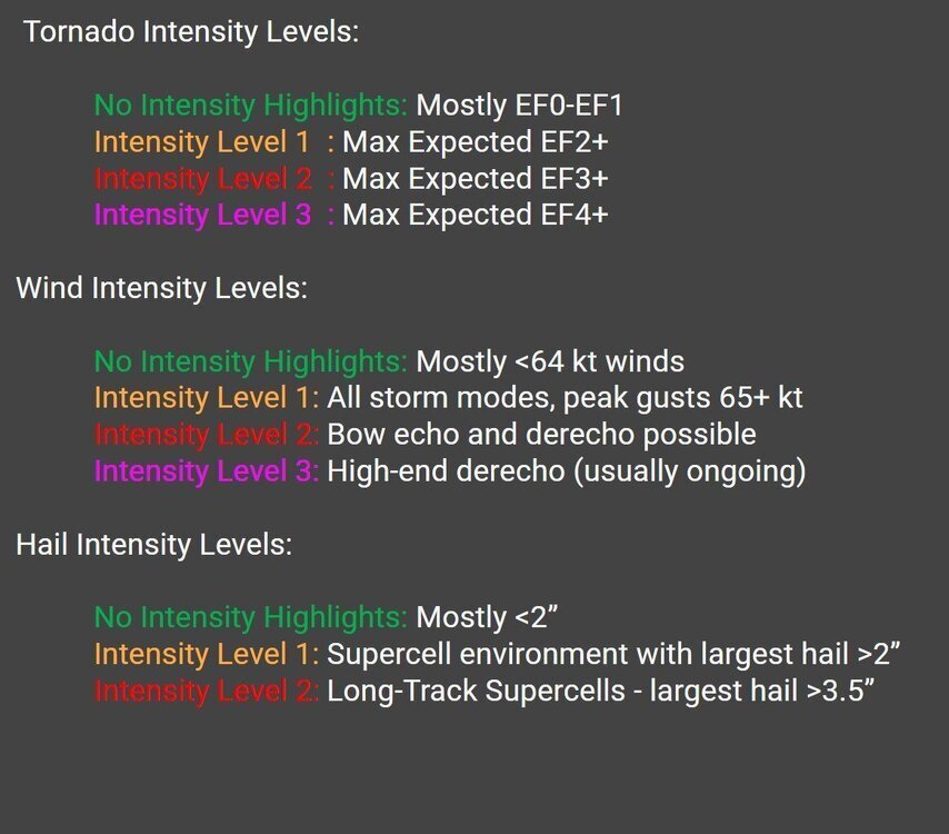
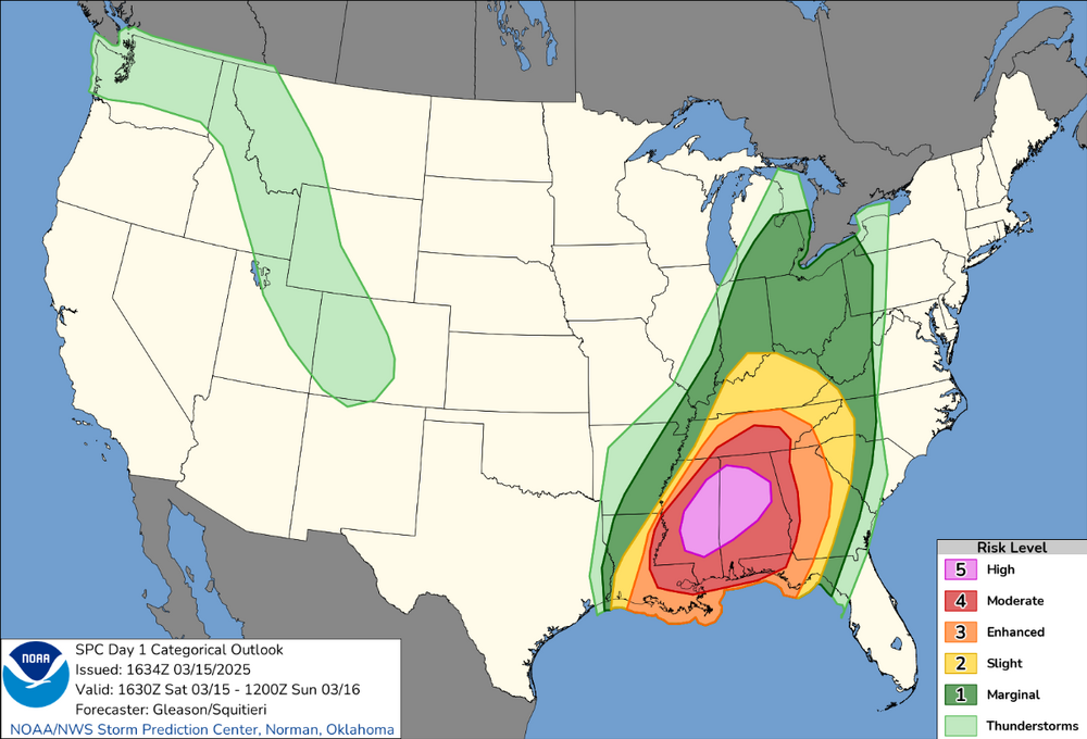
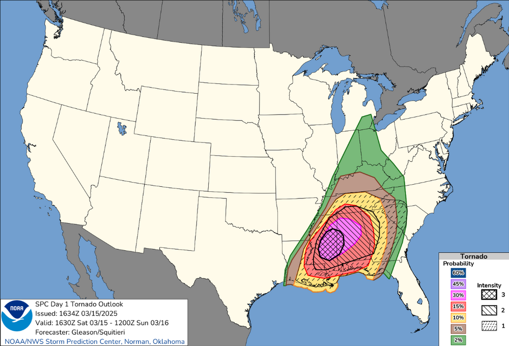
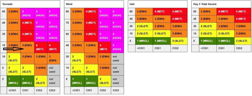 I've been studying the changes mentioned in my first post. As I understand it so far, the S.P.C. is keeping the same risk categories and should be issued as in the past. But now they are adding that the intensity of storms will now be conditional. This means if a tornado/wind gust/hail report occurs, this will be how strong/intense/large they expect it to be. So they have added 3 intensity levels (2 for hail) and the individual graphics. The categorical outlook graphics will have a visual update (including text moving labels from the image to a legend) but will otherwise represent the same expected impacts from each category as before. As I understand it, this means that numbers will no longer be added to the graphics. Just the color codes that correspond with the legend to the right of the graphic. These intensity forecasts will be represented by the SPC as "Intensity Levels" or "Conditional Intensity Groups" (CIG). In the event that severe hazards materialize, these three intensity distributions (CIG1, CIG2, and CIG3) will be used to convey the increasing intensity of significant severe hazards. The current operational "SIGN" label will be replaced by these new Conditional Intensity Groups, which will be displayed on the SPC Severe Weather Outlook Day 1, 2, and 3 graphics and distributed via the SPC Outlook product. This is how the probabilities and conditional intensity will be combined to create the outlook. The first column is the percentage chance of the event occurring. Across the bottom are the intensity levels. This means you can take the percentage row and move to the intensity column to get your risk. These are the same 5 risk levels used in the past, but now they are adding the intensity. I'm still studying this and will post any changes to how I understand it as I learn more. @theguru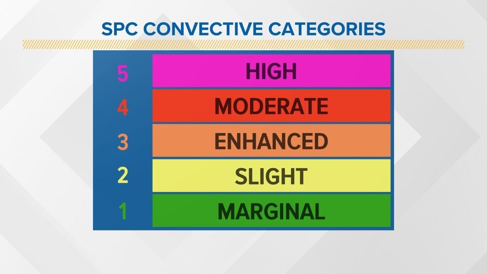
 Here's something else just released today. new Data Viewer for Severe Hazards. The dynamic and customizable data display on this page shows a 30-year history of lightning, wildfires, and severe storms. I can even obtain time-of-day data for one and four hours. Year, month, and day. They include all data or data from the previous 30 years. This provides the likelihood of every tornado or divides it into EF-1+, EF-2+, or EF-3+. Here are some maps for illustration. They cover March, April, May, and June. Here are some maps for illustration. They cover March, April, May, and June.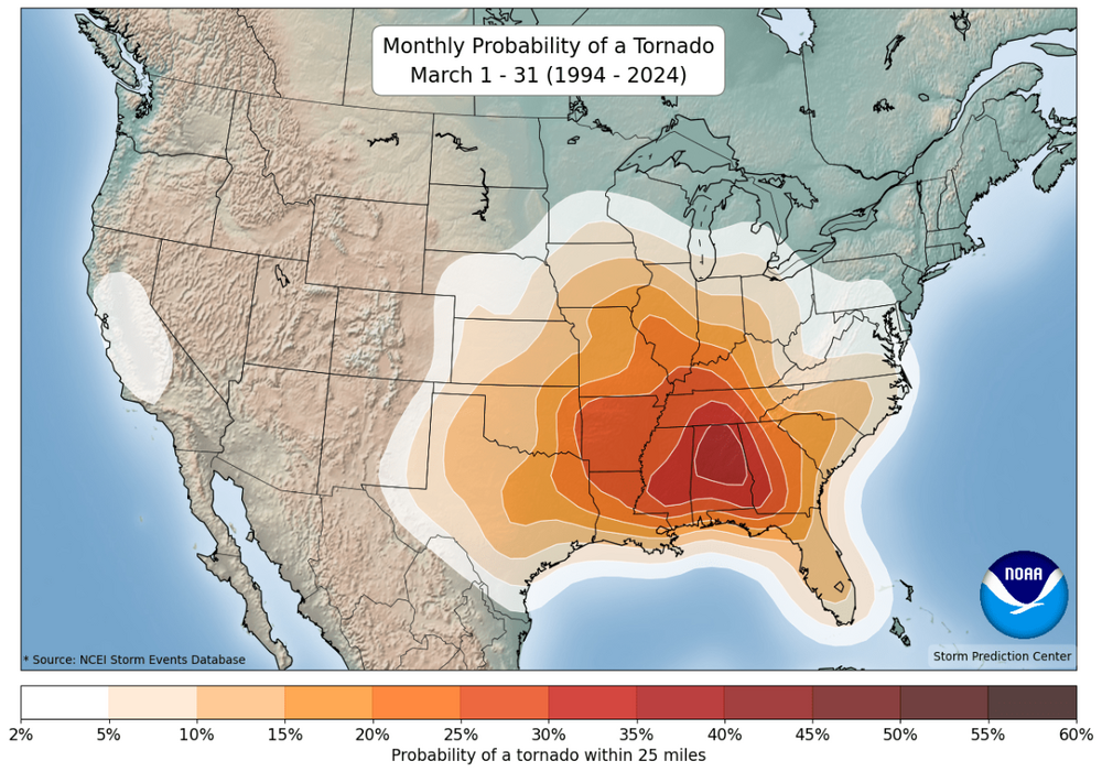
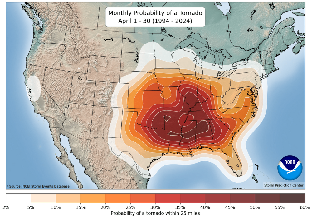
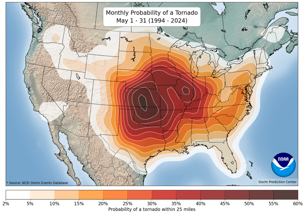
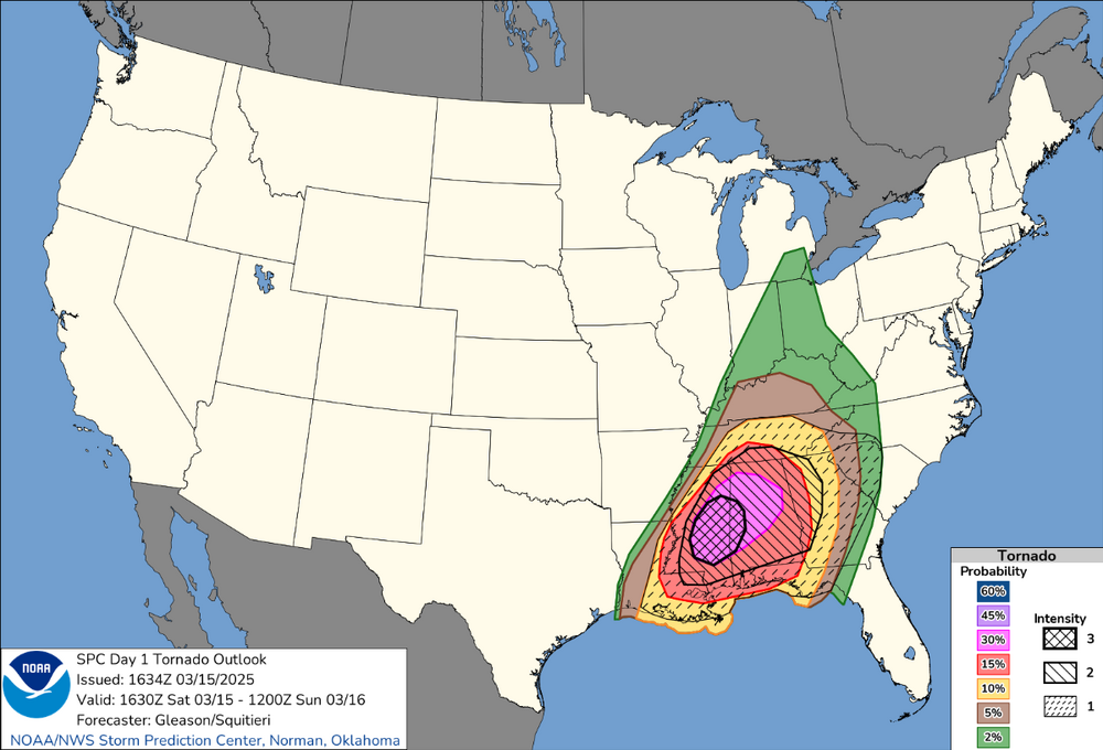
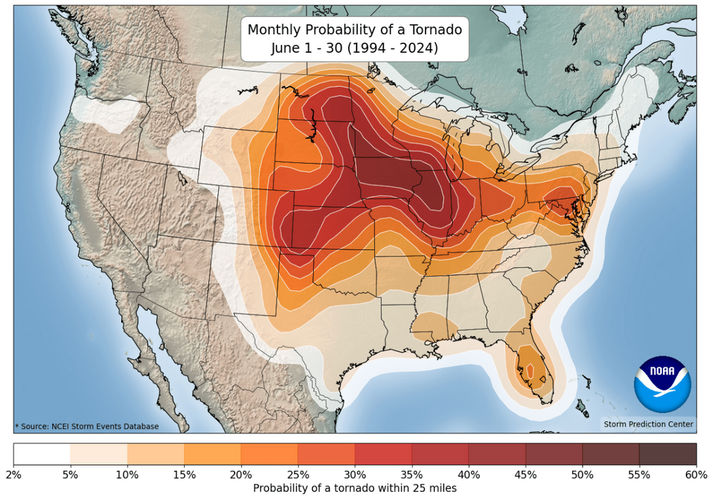 URGENT - WEATHER MESSAGE National Weather Service Wilmington OH 1233 PM EST Fri Jan 30 2026 OHZ026-042>046-051>056-060>065-070>073-077>080-310145- /O.UPG.KILN.CW.Y.0007.260131T0000Z-260131T1700Z/ /O.NEW.KILN.EC.W.0003.260131T0000Z-260131T1700Z/ Hardin-Darke-Shelby-Logan-Union-Delaware-Miami-Champaign-Clark- Madison-Franklin-Licking-Preble-Montgomery-Greene-Fayette- Pickaway-Fairfield-Butler-Warren-Clinton-Ross-Hamilton-Clermont- Brown-Highland- Including the cities of Blanchester, Beavercreek, Ripley, Piqua, Newark, London, Fairborn, Day Heights, Camden, Oxford, Greenville, West Jefferson, Urbana, Kenton, Hamilton, Sidney, Mulberry, Circleville, Withamsville, Wilmington, Georgetown, Bellefontaine, Xenia, Franklin, Troy, Mason, Hillsboro, Greenfield, Pickerington, Chillicothe, Mount Orab, Ada, Lancaster, Springfield, Delaware, Marysville, Middletown, Landen, Mount Carmel, Downtown Cincinnati, Summerside, Milford, Mount Repose, Tipp City, Washington Court House, Lebanon, Aberdeen, Eaton, Springboro, Kettering, Downtown Dayton, Fairfield, Downtown Columbus, and Plain City 1233 PM EST Fri Jan 30 2026 ...EXTREME COLD WARNING IN EFFECT FROM 7 PM THIS EVENING TO NOON EST SATURDAY... * WHAT...Dangerously cold wind chills as low as 22 below zero expected. * WHERE...Portions of central, south central, southwest, and west central Ohio. * WHEN...From 7 PM this evening to noon EST Saturday. * IMPACTS...The dangerously cold wind chills as low as 20 below zero could cause frostbite on exposed skin in as little as 30 minutes. PRECAUTIONARY/PREPAREDNESS ACTIONS... Dress in layers including a hat, face mask, and gloves if you must go outside. Keep pets indoors as much as possible. Make sure outdoor animals have a warm, dry shelter, food, and unfrozen water.@theguru I will start using this as well once training is completed. SPC will be introducing new information in Convective Outlooks starting in early March. The following thread will offer some basic information regarding these changes. The TL;DR: Outlook categories (1-5) are not changing! But there will be more info for peak hazard intensity. The old 10% significant hazard outline is being replaced by three intensity levels (two for hail). These thresholds are not tied to a probability. They are our best estimate of what the maximum hazard intensity could be based on expected storm mode and environmental parameters. Let's look at some examples of past outlooks & how they would look under this new intensity paradigm. In this tornado outlook, the old 10% hatched area is on the left. In the new intensity outlook (right), more detail is given showing where the strongest tornadoes are expected. The important thing to remember: outlook categories (Level 1-5: Marginal, Slight, Enhanced, Moderate, High) are not changing! A High risk in 2026 means the same thing as a High risk in 2025. Only now we can graphically show where we expect the most intense storms. Given the complexity of this change, we have developed a comprehensive training plan to ensure our Core Partners have access to detailed educational/training materials before we go live. This includes: NWS and broadcast meteorologists, emergency managers, and more! In addition, training information will be available on our YouTube channel later in February with different videos for various user groups. Links and information will be shared here, as well as on our webpage, www.spc.noaa.gov, as it becomes available. This project has been underway since 2019. It began in the Hazardous Weather Testbed (HWT) and SPC forecasters began drawing conditional intensity outlooks experimentally in 2021. This final product is the result on multiple iterations based on lessons learned for the HWT, social science research, and forecaster feedback. We are excited to bring higher-resolution outlook and hazard information to you this spring!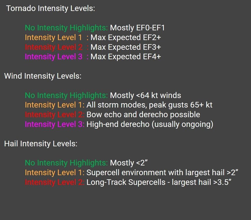
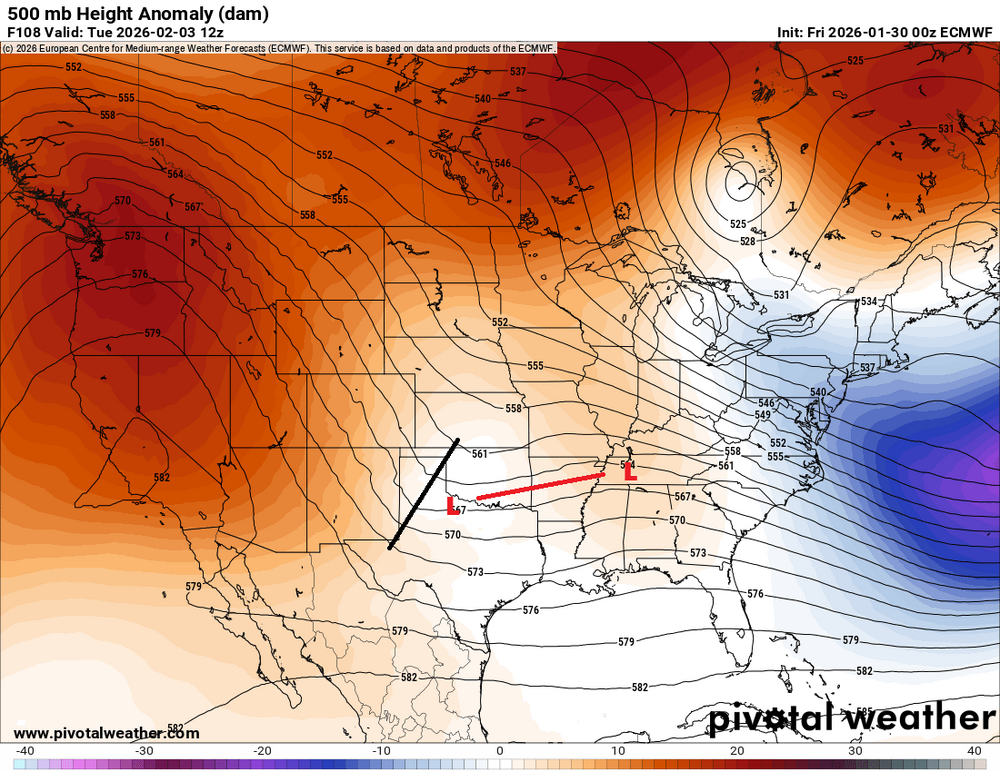
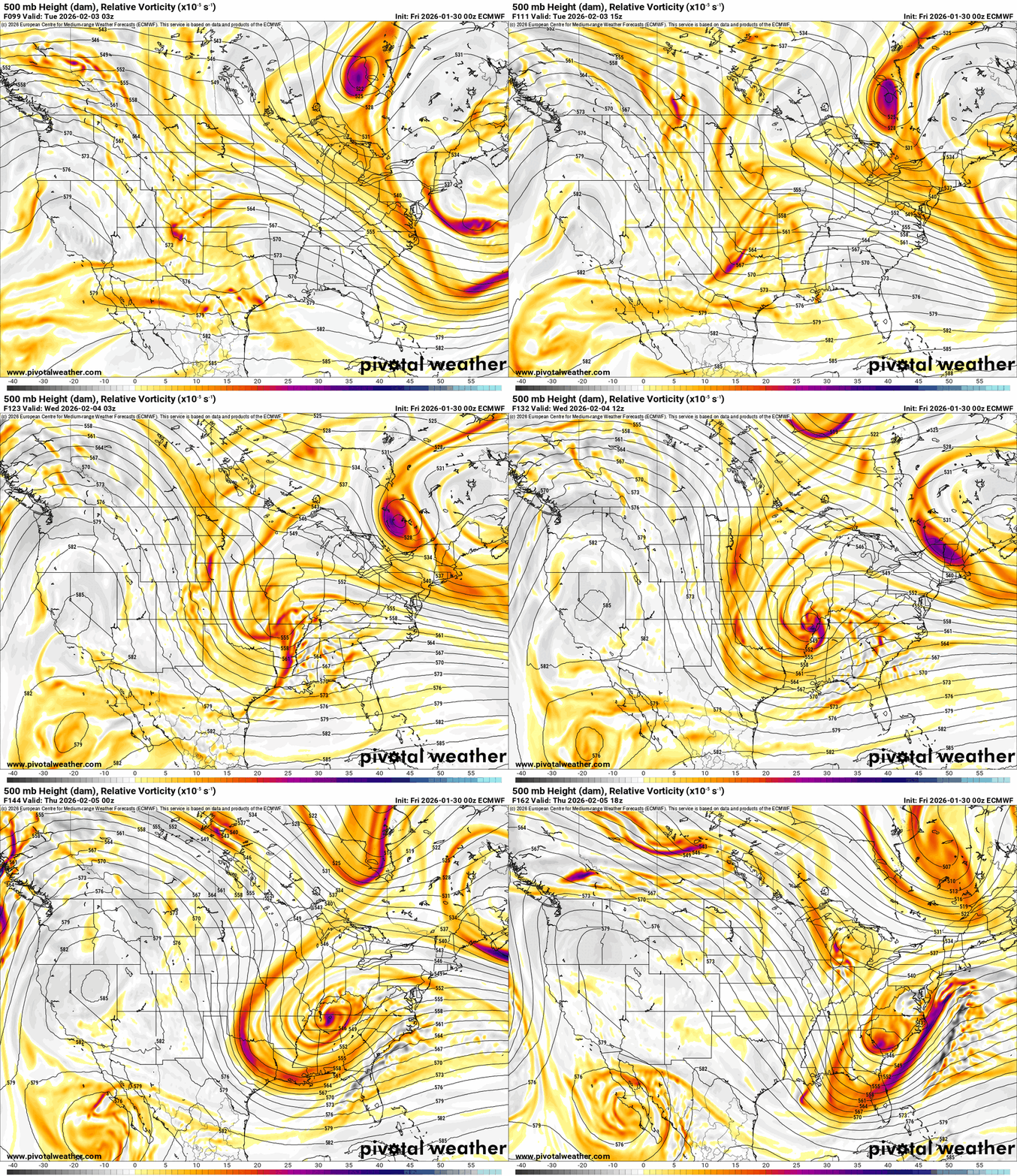
 On Monday afternoon, a short-wave trough will be located just east of the Rockies. As it progresses eastward, it is expected to strengthen and give rise to a low-pressure system near Texas. The trough will transition from a positive to a neutral and then to a slightly negative tilt, as indicated by the 500 mb height anomaly maps. During this shift, the low-pressure system will intensify as it approaches Kentucky, pulling in warm moisture from the Gulf. Precipitation is anticipated to begin on Tuesday afternoon or early evening. Snow may develop along the Ohio River, while freezing rain could occur in the region between I-64 and the Cumberland Parkway. Areas further south may experience rain. The arctic air circulating around the low will likely convert all precipitation to snow before it wraps up on Wednesday evening or early Thursday. While it's challenging to forecast total accumulations at this stage, the heaviest snowfall is expected to occur near and along the Ohio River. Additionally, there is a potential for freezing rain and ice accumulations south of I-64. The precise path of the system remains uncertain, and any shift to the north or south could short-wave trough Shortwave trough positive tilt neutral to negative tilt
.thumb.png.3e578b90a1fc63fff83a1160d6fa2b75.png)
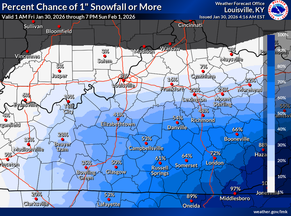
 Here are the chances of accumulating snow this weekend. NWS-Louisville Office NWS-Jackson Office
.thumb.png.3ce8c27ffa1689b921c94edc167c5bc7.png)
 First let me say this is just historical information. I'm not forecasting that any of this will happen. Just what happened in the past during, like, years of an ENSO-neutral phase in Kentucky. When we look at March, April, and May, we are looking at the absolute core of "Storm Season" in Kentucky. While 2011 and 2012 are legendary for their tornado outbreaks, 2025 has emerged as a historic outlier for its combination of record-shattering rainfall and a high-fatality May tornado. 2025: The Year of Record Extremes The spring of 2025 was relentless, featuring the state's second-highest annual tornado count and its most significant flooding in decades. March: 2025 saw the largest March tornado outbreak in U.S. history. In Kentucky, a 31-mile long-track EF1 tore through Fort Knox and Midway, while two people were tragically killed in storms near Fairdale and Clermont. April 2–6 (Historic Flooding): This week became one of the wettest in Kentucky history. Rainfall: Mayfield recorded a staggering 15.64 inches in just six days. Tornadoes: The period began with a massive 23-tornado outbreak on April 2nd, including an EF3 in Jeffersontown (Louisville) with 145 mph winds. Rivers: The Kentucky River at Frankfort hit its #2 all-time crest, and a new record was set at Camp Nelson. Seven people died in the flooding statewide. May 16 (The Somerset-London Disaster): A violent, nocturnal EF4 tornado carved a 60-mile path through Russell, Pulaski, and Laurel counties. Impact: 19 people were killed, primarily in the Sunshine Hill community near London. Winds were estimated at 170 mph, making it the deadliest tornado in the history of the NWS Jackson office. 2012: The March "Black Friday" Outbreak The spring of 2012 is almost entirely defined by the catastrophic events of early March, which remains a benchmark for Kentucky emergency management. March 2 (The Outbreak): 18 tornadoes struck Kentucky in a single day, killing 22 people. The town of West Liberty was nearly destroyed by an EF3. An EF4 struck Crittenden and Piner, leveling homes with 175 mph winds. April: Mostly known for a massive hail event. On April 28, "baseball-sized" hail caused $175 million in insured losses, battering Louisville and south-central Kentucky. May: Transitioned into a severe heat wave. While storms were fewer, the heat fueled intense microbursts, including 60+ mph winds that damaged structures in Hardin and Clark counties. 2011: The Year of 79 Tornadoes 2011 remains the state record holder for the most tornadoes in a single year (79), with the vast majority occurring in April. March: A transition month with heavy flooding in Eastern Kentucky and a few smaller tornadoes in Pulaski County. April (The "Super Outbreak" Era): April 19: A record-breaking day where 24 tornadoes were confirmed in the Louisville NWS area alone. April 25–28: While the national "Super Outbreak" decimated Alabama, Kentucky was hit with a barrage of EF1 and EF2 tornadoes and historic rainfall. Paducah saw nearly 16 inches of rain for the month. May: A late-month outbreak produced a long-track EF3 that traveled 48 miles through western Kentucky, causing significant damage near Bardwell. Spring Comparison (March–May) Metric 2011 2012 2025 Max Tornado Strength EF3 EF4 EF4 Total Fatalities (Spring) 0 (in major outbreaks) 22 (all in March) 28 (March/April/May) Primary Theme Record Frequency Violent March Outbreak Catastrophic Flooding Wettest City Paducah (15.90" in April) N/A Mayfield (15.64" in 1 week)RGENT - WEATHER MESSAGE National Weather Service Louisville KY 247 PM EST Thu Jan 29 2026 INZ076>079-083-084-089>092-KYZ023>043-045>049-053>057-061>067- 070>078-081-082-301000- /O.NEW.KLMK.CW.Y.0005.260131T0600Z-260131T1800Z/ Orange-Washington IN-Scott IN-Jefferson IN-Dubois-Crawford-Perry- Harrison IN-Floyd-Clark IN-Hancock-Breckinridge-Meade-Ohio- Grayson-Hardin-Bullitt-Jefferson-Oldham-Trimble-Henry-Shelby- Franklin-Scott KY-Harrison KY-Spencer-Anderson-Woodford-Fayette- Bourbon-Nicholas-Nelson-Washington KY-Mercer-Jessamine-Clark KY- Larue-Marion-Boyle-Garrard-Madison-Butler-Edmonson-Hart-Green- Taylor-Casey-Lincoln-Logan-Warren-Simpson-Allen-Barren-Monroe- Metcalfe-Adair-Russell-Cumberland-Clinton- Including the cities of Salem, Lawrenceburg, Greensburg, Milton, Hartford, Frankfort, Lexington, La Grange, Brownsville, Morgantown, Edmonton, Horse Cave, Glasgow, Springfield, Harrodsburg, Scottsville, Bedford, Albany, Jasper, Jamestown, Madison, Lancaster, Hardinsburg, Bowling Green, Taylorsville, Carlisle, Lebanon, Versailles, Louisville, Cynthiana, Bardstown, Paoli, Columbia, Danville, Campbellsville, Franklin, Shepherdsville, Stanford, Elizabethtown, English, Georgetown, Paris, Burkesville, Winchester, Liberty, Lewisport, Russellville, Shelbyville, Jeffersonville, Providence, Nicholasville, New Castle, Scottsburg, Richmond, Corydon, Hodgenville, Brandenburg, Hawesville, New Albany, Leitchfield, Tell City, and Tompkinsville 247 PM EST Thu Jan 29 2026 /147 PM CST Thu Jan 29 2026/ ...COLD WEATHER ADVISORY IN EFFECT FROM 1 AM EST /MIDNIGHT CST/ TO 1 PM EST /NOON CST/ SATURDAY... * WHAT...Very cold wind chills as low as 11 below expected. * WHERE...Portions of south central Indiana and central Kentucky. * WHEN...From 1 AM EST /midnight CST/ to 1 PM EST /noon CST/ Saturday. * IMPACTS...The cold wind chills as low as 11 below zero could result in hypothermia if precautions are not taken. PRECAUTIONARY/PREPAREDNESS ACTIONS... Use caution while traveling outside. Wear appropriate clothing, a hat, and gloves. Keep pets indoors as much as possible. Make frequent checks on older family, friends, and neighbors. Ensure portable heaters are used correctly. Do not use generators or grills inside.RGENT - WEATHER MESSAGE National Weather Service Louisville KY 247 PM EST Thu Jan 29 2026 INZ076>079-083-084-089>092-KYZ023>043-045>049-053>057-061>067- 070>078-081-082-301000- /O.NEW.KLMK.CW.Y.0005.260131T0600Z-260131T1800Z/ Orange-Washington IN-Scott IN-Jefferson IN-Dubois-Crawford-Perry- Harrison IN-Floyd-Clark IN-Hancock-Breckinridge-Meade-Ohio- Grayson-Hardin-Bullitt-Jefferson-Oldham-Trimble-Henry-Shelby- Franklin-Scott KY-Harrison KY-Spencer-Anderson-Woodford-Fayette- Bourbon-Nicholas-Nelson-Washington KY-Mercer-Jessamine-Clark KY- Larue-Marion-Boyle-Garrard-Madison-Butler-Edmonson-Hart-Green- Taylor-Casey-Lincoln-Logan-Warren-Simpson-Allen-Barren-Monroe- Metcalfe-Adair-Russell-Cumberland-Clinton- Including the cities of Salem, Lawrenceburg, Greensburg, Milton, Hartford, Frankfort, Lexington, La Grange, Brownsville, Morgantown, Edmonton, Horse Cave, Glasgow, Springfield, Harrodsburg, Scottsville, Bedford, Albany, Jasper, Jamestown, Madison, Lancaster, Hardinsburg, Bowling Green, Taylorsville, Carlisle, Lebanon, Versailles, Louisville, Cynthiana, Bardstown, Paoli, Columbia, Danville, Campbellsville, Franklin, Shepherdsville, Stanford, Elizabethtown, English, Georgetown, Paris, Burkesville, Winchester, Liberty, Lewisport, Russellville, Shelbyville, Jeffersonville, Providence, Nicholasville, New Castle, Scottsburg, Richmond, Corydon, Hodgenville, Brandenburg, Hawesville, New Albany, Leitchfield, Tell City, and Tompkinsville 247 PM EST Thu Jan 29 2026 /147 PM CST Thu Jan 29 2026/ ...COLD WEATHER ADVISORY IN EFFECT FROM 1 AM EST /MIDNIGHT CST/ TO 1 PM EST /NOON CST/ SATURDAY... * WHAT...Very cold wind chills as low as 11 below expected. * WHERE...Portions of south central Indiana and central Kentucky. * WHEN...From 1 AM EST /midnight CST/ to 1 PM EST /noon CST/ Saturday. * IMPACTS...The cold wind chills as low as 11 below zero could result in hypothermia if precautions are not taken. PRECAUTIONARY/PREPAREDNESS ACTIONS... Use caution while traveling outside. Wear appropriate clothing, a hat, and gloves. Keep pets indoors as much as possible. Make frequent checks on older family, friends, and neighbors. Ensure portable heaters are used correctly. Do not use generators or grills inside.As La Niña diminishes and ENSO-neutral conditions emerge, Kentucky is anticipated to experience a spring characterized by increased activity and variability. Overall, temperatures are expected to hover around average to slightly above average, especially in the early part of the season, where fluctuations will be common. Rainfall is projected to be more abundant, including instances of heavy downpours that may heighten the risk of flooding during intense storm systems. The likelihood of severe weather will increase throughout April and May, following a typical spring pattern that includes strong thunderstorms, damaging winds, large hail, and potential tornadoes as moisture from the Gulf returns and storm systems move through the area. Historical context indicates that Kentucky has experienced similar spring weather patterns during previous ENSO-neutral or transition years, featuring active storm seasons and significant rainfall events. Notable examples include the spring of 2011, which brought historic flooding; spring 2012, marked by major tornado outbreaks; and spring 2025, which experienced severe storms and flooding. These instances illustrate the unpredictability and volatility of spring weather when large-scale climate influences weaken, allowing regional storm patterns to take precedence. In summary, Kentucky is transitioning from winter variability to a spring that promises to be stormier and wetter, with an escalating potential for severe weather and less predictable weekly conditions. Information comes from the Climate Prediction Center.URGENT - WINTER WEATHER MESSAGE National Weather Service Jackson KY 150 PM EST Thu Jan 29 2026 KYZ068-069-079-080-083-084-109-112-114-119-300300- /O.NEW.KJKL.WW.Y.0004.260130T1100Z-260131T0800Z/ Rockcastle-Jackson-Pulaski-Laurel-Wayne-McCreary-Magoffin- Breathitt-Owsley-Martin- Including the cities of Brodhead, Burnside, Jackson, Monticello, Salyersville, London, Annville, Whitley City, Inez, Stearns, Somerset, Booneville, Mount Vernon, and McKee 150 PM EST Thu Jan 29 2026 ...WINTER WEATHER ADVISORY IN EFFECT FROM 6 AM FRIDAY TO 3 AM EST SATURDAY... * WHAT...Snow expected. Total snow accumulations of 1 to 2 inches. * WHERE...Portions of northeast, south central, and southeast Kentucky. * WHEN...From 6 AM Friday to 3 AM EST Saturday. * IMPACTS...Plan on slippery road conditions. The hazardous conditions could impact the Friday morning and evening commutes. PRECAUTIONARY/PREPAREDNESS ACTIONS... Slow down and use caution while traveling. The latest road conditions for Kentucky can be found by visiting https://goky.ky.gov.


.png.d04b7dc847558d8eaa88e24e9963a785.png)




.png.31f959783ffd2f9bec71b03848d95feb.png)
.png.aa2e76f58e78c4ec886360c33d9f928e.png)




.png.40f2d5c6a29cfe3cda890737f1dfe4bb.png)






.png.bd585e5180fdcd0485d011d0dac67811.png)


.png.4737c04658f1967427b7d31b64b65c03.png)
