

nWo
BGP Meteorologist
-
Joined
-
Last visited
Everything posted by nWo
-
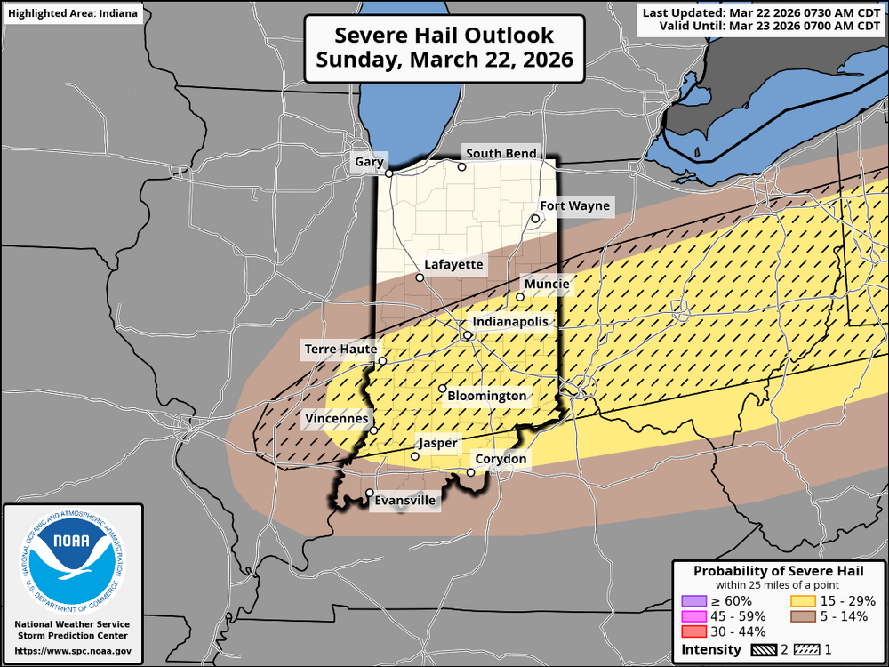
Update: In the Kentucky and Cincinnati areas, today's weather is characterized by two distinct phases: an unusually warm afternoon followed by a late evening that may bring severe storms. High temperatures in the Cincinnati metropolitan area and much of Northern and Central Kentucky are expected to reach the upper 70s to low 80s, accompanied by partly cloudy skies. This warmth, along with rising dewpoints in the upper 50s, will contribute to an increasingly unstable atmosphere. Although the early afternoon should remain dry thanks to a layer of warmer air aloft, this stability is likely to diminish as a cold front approaches from the northwest. Thunderstorms in the Cincinnati region and along the Interstate 75 corridor in Kentucky are anticipated to develop later than those in areas to the east, with the most probable timeframe for storm activity falling between 7:00 PM and midnight (23Z-04Z). The passage of a shortwave trough will provide the necessary uplift to break the cap and stimulate convective activity along the advancing front. Since this storm initiation will occur later in the day, there is a chance that storms may become elevated, forming just above a cooler surface layer. However, the strong mid-level lapse rates ensure that any storms that do form will have ample energy available. The main severe weather threat for Cincinnati and Northern Kentucky will be large hail, as the combination of steep lapse rates and robust deep-layer shear is favorable for the development of organized storm structures, including supercells. Residents should be prepared for the possibility of hail measuring 1 to 2 inches in diameter. While the risk of tornadoes is considered low due to relatively high cloud bases and insufficient low-level moisture, it is not entirely absent, especially if any storms manage to stay surface-based before the front fully advances. As the evening transitions into the night, the storms are expected to evolve into a more linear or squally formation as the cold front moves south and east across Kentucky. This change will shift the primary threat from large hail to damaging wind gusts. Following the passage of the front, a significant change in air mass will take place, with temperatures expected to drop nearly 40 degrees by Monday morning. Residents are advised to secure outdoor objects before sunset and to have a means of receiving weather alerts late tonight as the front approaches.
-
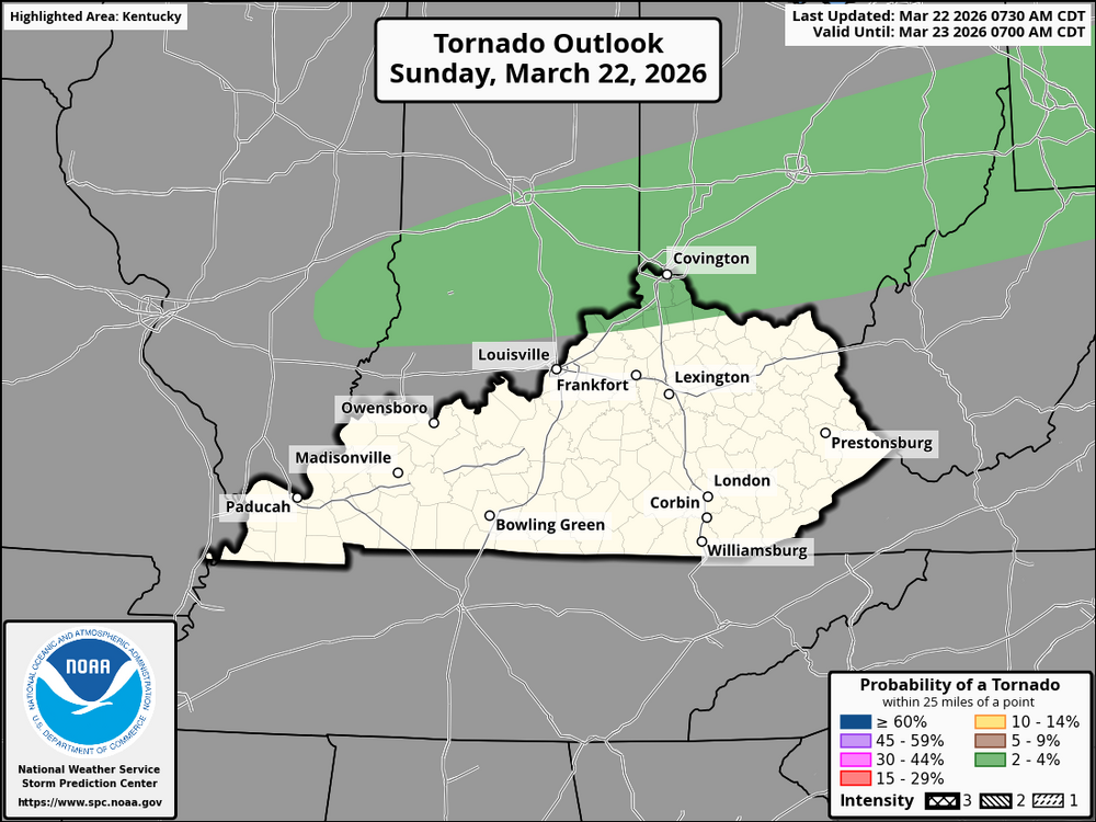
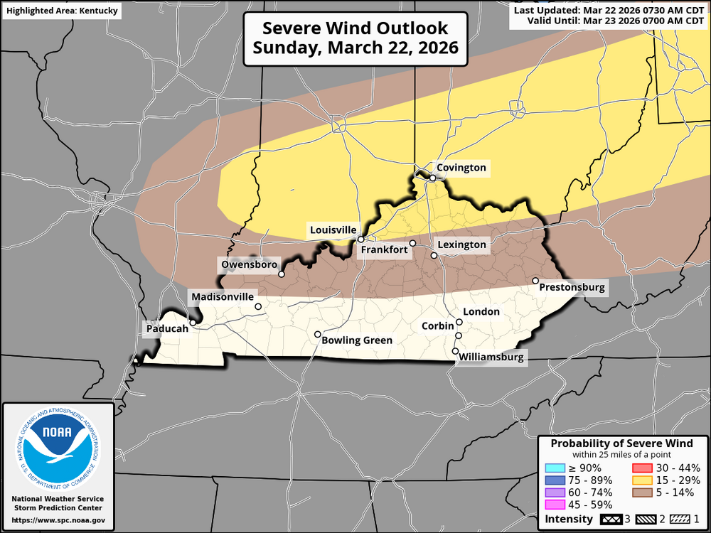
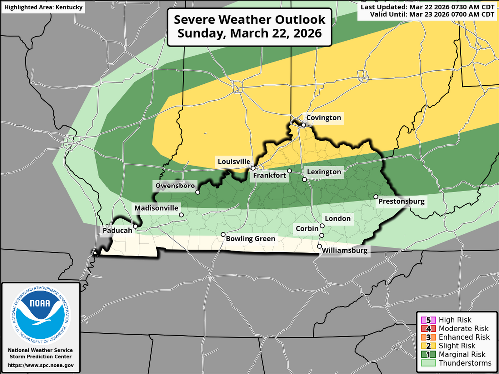
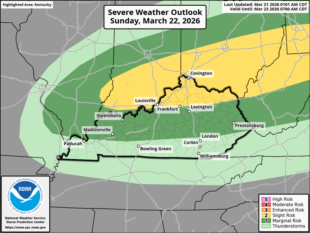
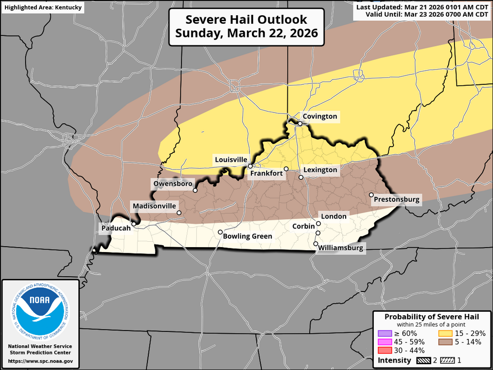
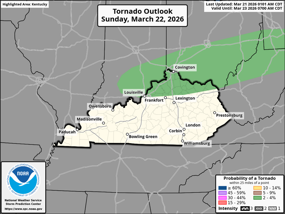
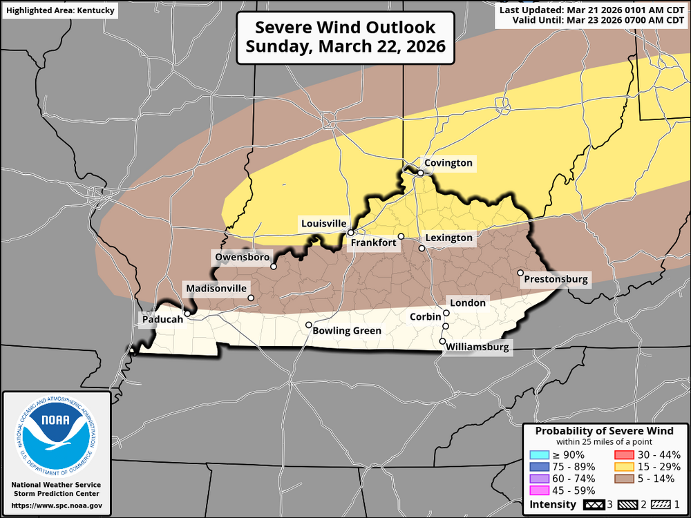
BGP Severe Weather Alert Day is in effect. Today, Sunday, March 22, 2026, residents of the Cincinnati area and much of Kentucky face the possibility of severe weather as a cold front moves south-southeast through the Ohio Valley. Although the most intense storm activity is likely to occur just northeast in Ohio and Pennsylvania, Cincinnati and northern Kentucky are classified within a slight risk (Level 2 of 5) for this afternoon and evening. In the Cincinnati metropolitan area, the initial storms may take the form of discrete or semi-discrete supercells. As the evening unfolds and the cold front advances further into Kentucky, these storms are expected to develop into a more organized line. By late evening and into the overnight hours, additional storm activity is anticipated across central and southern Kentucky. However, these later storms might be elevated or post-frontal, meaning they will occur behind the surface cold front. The primary hazards for the Cincinnati area and northern Kentucky today include the risk of large to very large hail. Given the steep mid-level lapse rates and favorable deep-layer shear of 40-50+ knots, any sustained supercell could produce hailstones measuring between 1.5 and 2.5 inches in diameter, comparable to ping-pong to tennis ball size. Additionally, damaging wind gusts pose a significant danger, particularly as storms merge into a line later in the evening. There is also some potential for a tornado or two along the front, although this risk is somewhat mitigated by a well-mixed boundary layer that keeps cloud bases relatively high.
-
This Sunday, folks in Kentucky and Cincinnati might want to keep an eye on the weather, as a wave of unstable air is moving in from the Southwest and Central Plains. The eastern part of the Ohio Valley, particularly areas like Pennsylvania and eastern Ohio, is likely to see the most intense storm development, thanks to conditions that are perfect for supercells. Now, while Kentucky and Cincinnati may not see quite the same level of storm activity, there’s still a chance for isolated supercells, especially in the afternoon and evening as that cold front rolls in. If these supercells do pop up, be on the lookout for large hail, possibly as big as golf balls. Plus, with some daytime heating, we could see damaging winds in certain areas. There’s also a bit of a tornado risk, but that largely depends on how much low-level moisture is available. As night falls, we can expect storm coverage to increase; however, much of this activity will likely be at a higher altitude, which means it might not be as severe, although strong winds could still be an issue. In short, Kentucky and Cincinnati should brace for a busy Sunday, with the most significant risk for severe weather peaking in the afternoon and evening. As the front shifts southeast, the storm threat will gradually lessen into the night, but don't be surprised if some elevated storms and gusty winds stick around.
-
On Sunday afternoon, a cold front will make its way southward through the Ohio Valley, affecting areas like Cincinnati, Northern Kentucky, and the rest of Kentucky. As we head into the early afternoon, we can expect some moderate instability to build up, with surface dewpoints hovering in the low to mid-60s°F and temperatures on the rise. This setup is likely to spark the development of storms along the front, particularly during the mid to late afternoon hours. As the afternoon progresses, severe thunderstorms are anticipated to form, and we’ll see an increase in storm coverage throughout the region, especially in places like Cincinnati and Northern Kentucky, as well as central and eastern Kentucky. The ongoing surface heating will create strong low-level convergence, which should help kickstart the storms along the front. By late afternoon and into early evening, these storms will be moving southeast across Kentucky. The forecast shows some impressive MLCAPE values between 1500 and 2000 J/kg, which bodes well for severe storm activity. While surface winds will be coming from the southwest, there will also be significant speed shear in the mid-levels, ranging from 40 to 50 knots, further supporting the development of severe storms. The lapse rates are expected to fall between 7.0 and 7.5°C/km, a range that favors the formation of supercells capable of producing large hail. The highest risk for large hail and isolated tornadoes will be at the beginning of the storm event, especially in Cincinnati, Northern Kentucky, and parts of central Kentucky, where storms are more likely to be discrete. Additionally, there is a threat of wind damage, particularly from short-line segments of storms that may form later in the afternoon and into the evening. There's also a slight chance of isolated supercells producing tornadoes. In the lower Ohio Valley and mid-Mississippi Valley, a strong capping inversion will be present over the warm sector in the early part of the day. However, as the cold front approaches, this cap is expected to weaken, which will allow for some isolated severe storms to develop along the front. The potential for hail and strong wind gusts will remain with the more robust cells as they form and persist into the evening.
-
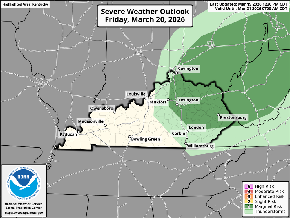
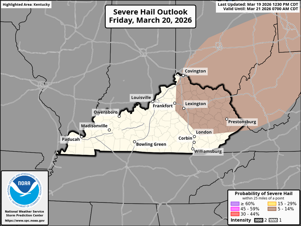
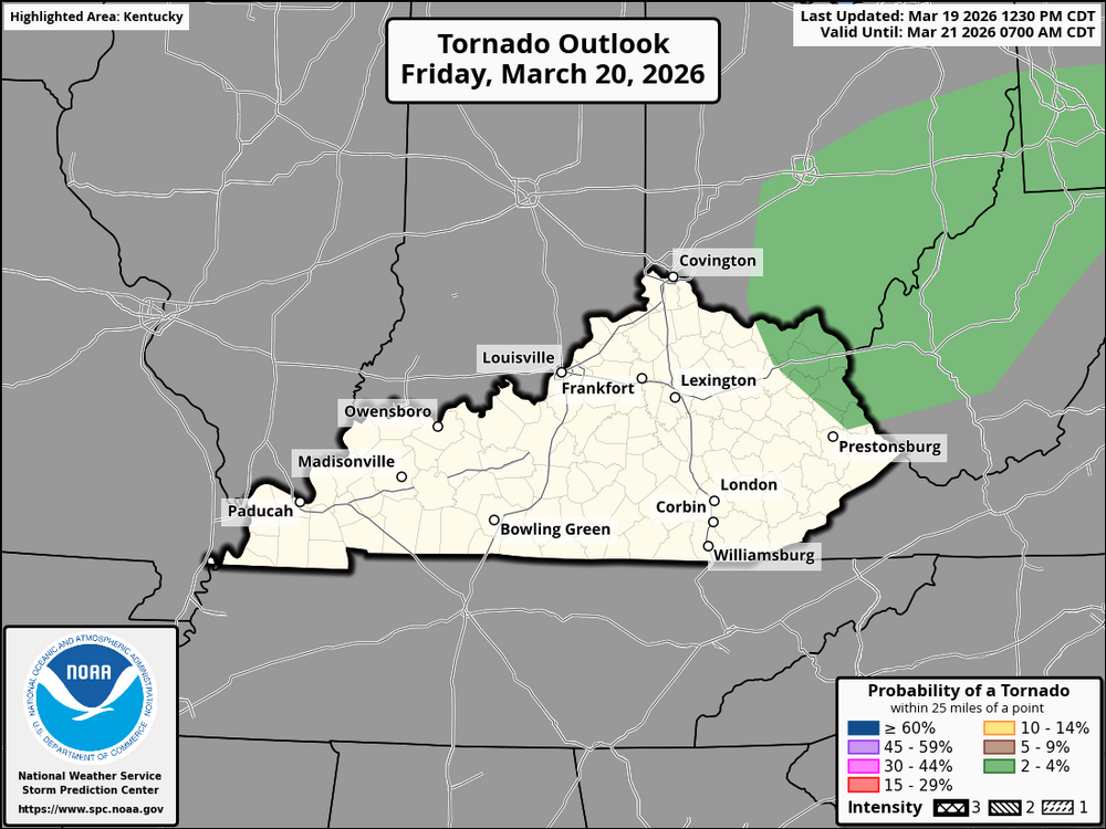
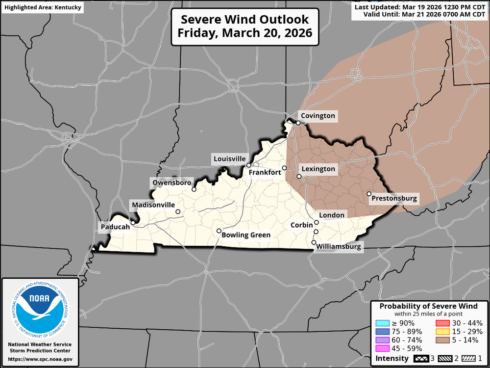
On Friday, March 22, 2026, the weather forecast for Cincinnati, Northern Kentucky, Lexington, and Northeast Kentucky suggests a marginal risk for severe weather, with the likelihood of strong thunderstorms forming during the afternoon and evening. The day will begin with a modest increase in moisture, characterized by dewpoints in the low to mid-50s, which will contribute to a slightly unstable atmosphere. Although the level of instability is not particularly high, it could still support storm development later in the day, especially as the atmosphere starts to destabilize. By late afternoon, around 3 PM and thereafter, conditions are expected to become more conducive for storm formation across all these areas. The most significant threat from storms is anticipated between 3 PM and 9 PM, when isolated thunderstorms could intensify, particularly in the regions of Lexington, Cincinnati, and Northern Kentucky. The primary risks associated with these storms include marginally severe hail (up to 1 inch in diameter), damaging winds with gusts reaching 50-60 mph, and isolated tornadoes, which remain a possibility but are less likely and highly dependent on the presence of low-level moisture and storm organization. In Cincinnati and Northern Kentucky, deep-layer shear may assist in organizing a few storms; however, the overall instability is weak, which constrains the potential for widespread severe weather. The risk of tornadoes is low but cannot be entirely ruled out, particularly if storms manage to access richer moisture and maintain surface-based convection. Similarly, in Lexington and Northeast Kentucky, the risk profile is comparable. Storms could emerge by late afternoon, and like in Cincinnati and Northern Kentucky, the main threats will involve hail and gusty winds. The tornado risk here is also minimal, but it is important to stay vigilant as conditions may change throughout the afternoon. As the evening progresses, specifically after 9 PM, the risk of severe weather is expected to diminish as storms lose their intensity due to a decline in instability. In summary, the main concerns for Cincinnati, Northern Kentucky, Lexington, and Northeast Kentucky on Friday include marginally severe hail, strong winds, and a low tornado risk, particularly during the window of 3 PM to 9 PM. It is advisable to monitor local weather reports for any updates or warnings as the situation unfolds
-
The forecast for Kentucky predicts an overall mild to cool pattern as a result of mid-level troughing to the north. As the trough over eastern Canada and the Great Lakes region affects the region, temperatures in the state will be near- to slightly below-normal, particularly in the eastern and northern portions. The central and western parts of Kentucky may see slightly warmer temperatures, but they are expected to stay within a few degrees of normal. Precipitation is expected to be below normal across much of Kentucky, with fewer chances of significant rain. The dry conditions will be more pronounced in the state's western and central regions, where expansive ridging from the southwest is expected to reduce moisture. The eastern part of Kentucky, on the other hand, may see slightly more precipitation due to the proximity of the mid-level trough in the eastern United States. Overall, Kentucky's weather will likely be characterized by mostly dry conditions with average to slightly cooler temperatures.SEVERE THUNDERSTORM WATCH OUTLINE UPDATE FOR WS 62 NWS STORM PREDICTION CENTER NORMAN OK 1240 AM EDT MON MAR 16 2026 SEVERE THUNDERSTORM WATCH 62 IS IN EFFECT UNTIL 700 AM EDT FOR THE FOLLOWING LOCATIONS KYC011-013-025-051-063-065-069-071-095-109-115-119-121-125-127- 129-131-133-147-153-159-165-173-175-189-193-195-197-199-203-205- 231-235-237-161100- /O.NEW.KWNS.SV.A.0062.260316T0440Z-260316T1100Z/ KY . KENTUCKY COUNTIES INCLUDED ARE BATH BELL BREATHITT CLAY ELLIOTT ESTILL FLEMING FLOYD HARLAN JACKSON JOHNSON KNOTT KNOX LAUREL LAWRENCE LEE LESLIE LETCHER MAGOFFIN MARTIN MCCREARY MENIFEE MONTGOMERY MORGAN OWSLEY PERRY PIKE POWELL PULASKI ROCKCASTLE ROWAN WAYNE WHITLEY WOLFEWATCH COUNTY NOTIFICATION FOR WATCH 58 NATIONAL WEATHER SERVICE LOUISVILLE KY 1146 PM EDT SUN MAR 15 2026 KYC017-049-067-079-097-113-137-151-181-209-160900- /O.EXB.KLMK.TO.A.0058.000000T0000Z-260316T0900Z/ THE NATIONAL WEATHER SERVICE HAS EXTENDED TORNADO WATCH 58 TO INCLUDE THE FOLLOWING AREAS UNTIL 5 AM EDT MONDAY IN KENTUCKY THIS WATCH INCLUDES 10 COUNTIES IN CENTRAL KENTUCKY BOURBON CLARK FAYETTE GARRARD HARRISON JESSAMINE LINCOLN MADISON NICHOLAS SCOTT THIS INCLUDES THE CITIES OF BEREA, BRECKINRIDGE, BRYANTSVILLE, BUCKEYE, CARLISLE, CLINTONVILLE, COLVILLE, CYNTHIANA, FORD, GEORGETOWN, HIGH BRIDGE, HOOKTOWN, KEENE, KINGSTON, KIRKSVILLE, LANCASTER, LEESBURG, LEXINGTON, LOWELL, MCCREARY, MYERS, NEW ZION, NEWTOWN, NICHOLASVILLE, ODDVILLE, OXFORD, PAINT LICK, PARIS, REDHOUSE, RICHMOND, ROWLAND, RUCKERVILLE, STANFORD, VALLEY VIEW, WILMORE, AND WINCHESTER.SEVERE THUNDERSTORM WATCH OUTLINE UPDATE FOR WS 61 NWS STORM PREDICTION CENTER NORMAN OK 1150 PM EDT SUN MAR 15 2026 SEVERE THUNDERSTORM WATCH 61 IS IN EFFECT UNTIL 400 AM EDT FOR THE FOLLOWING LOCATIONS KYC015-019-023-037-043-081-089-117-135-161-191-201-160800- /O.NEW.KWNS.SV.A.0061.260316T0350Z-260316T0800Z/ KY . KENTUCKY COUNTIES INCLUDED ARE BOONE BOYD BRACKEN CAMPBELL CARTER GRANT GREENUP KENTON LEWIS MASON PENDLETON ROBERTSON $$
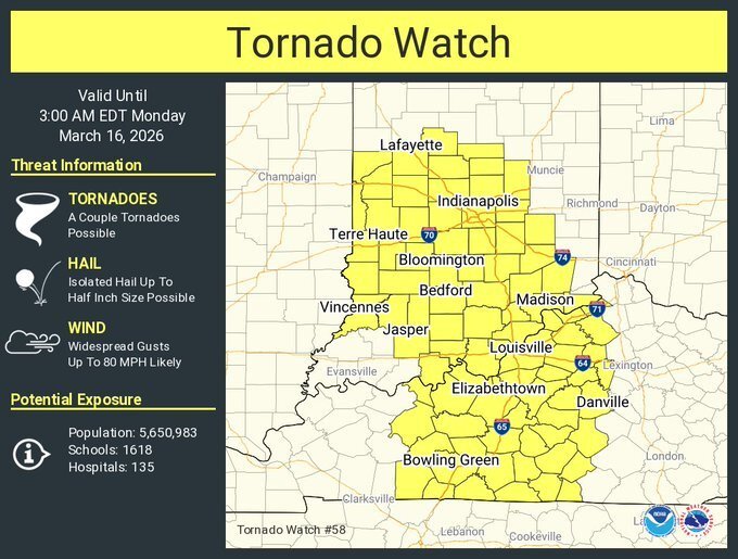
 New tornado watch URGENT - IMMEDIATE BROADCAST REQUESTED Tornado Watch Number 58 NWS Storm Prediction Center Norman OK 825 PM EDT Sun Mar 15 2026 The NWS Storm Prediction Center has issued a * Tornado Watch for portions of Central and Southern Indiana Central and Northern Kentucky * Effective this Sunday night and Monday morning from 825 PM until 300 AM EDT. * Primary threats include... A couple tornadoes possible Widespread damaging winds and isolated significant gusts to 80 mph likely SUMMARY...A severe squall line is forecast to rapidly move east-northeast across the Watch area this evening into tonight. Damaging gusts will likely be the most prevalent hazard, but a couple of tornadoes are also possible with embedded mesovortices within the squall line. The tornado watch area is approximately along and 60 statute miles east and west of a line from 20 miles east northeast of Lafayette IN to 25 miles southeast of Bowling Green KY. For a complete depiction of the watch see the associated watch outline update (WOUS64 KWNS WOU8). PRECAUTIONARY/PREPAREDNESS ACTIONS... REMEMBER...A Tornado Watch means conditions are favorable for tornadoes and severe thunderstorms in and close to the watch area. Persons in these areas should be on the lookout for threatening weather conditions and listen for later statements and possible warnings. @theguru
 TORNADO WATCH OUTLINE UPDATE FOR WT 55 NWS STORM PREDICTION CENTER NORMAN OK 355 PM CDT SUN MAR 15 2026 TORNADO WATCH 55 IS IN EFFECT UNTIL 1100 PM CDT FOR THE FOLLOWING LOCATIONS KYC007-033-035-039-047-055-059-075-083-101-105-107-139-143-145- 149-157-177-219-221-225-233-160400- /O.NEW.KWNS.TO.A.0055.260315T2055Z-260316T0400Z/ KY . KENTUCKY COUNTIES INCLUDED ARE BALLARD CALDWELL CALLOWAY CARLISLE CHRISTIAN CRITTENDEN DAVIESS FULTON GRAVES HENDERSON HICKMAN HOPKINS LIVINGSTON LYON MARSHALL MCCRACKEN MCLEAN MUHLENBERG TODD TRIGG UNION WEBSTER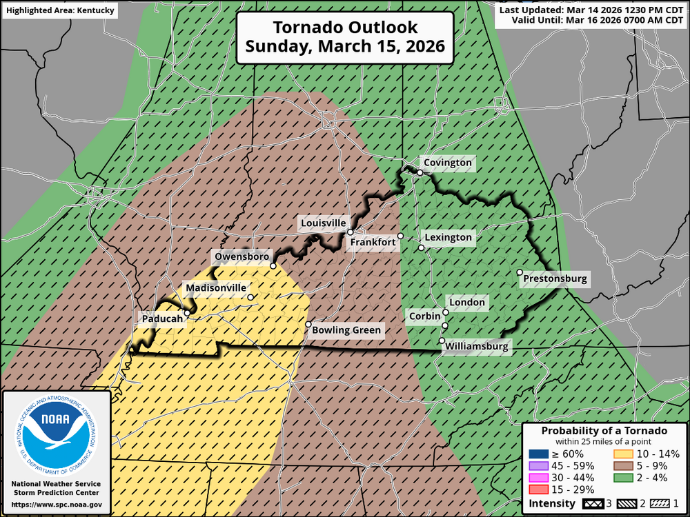
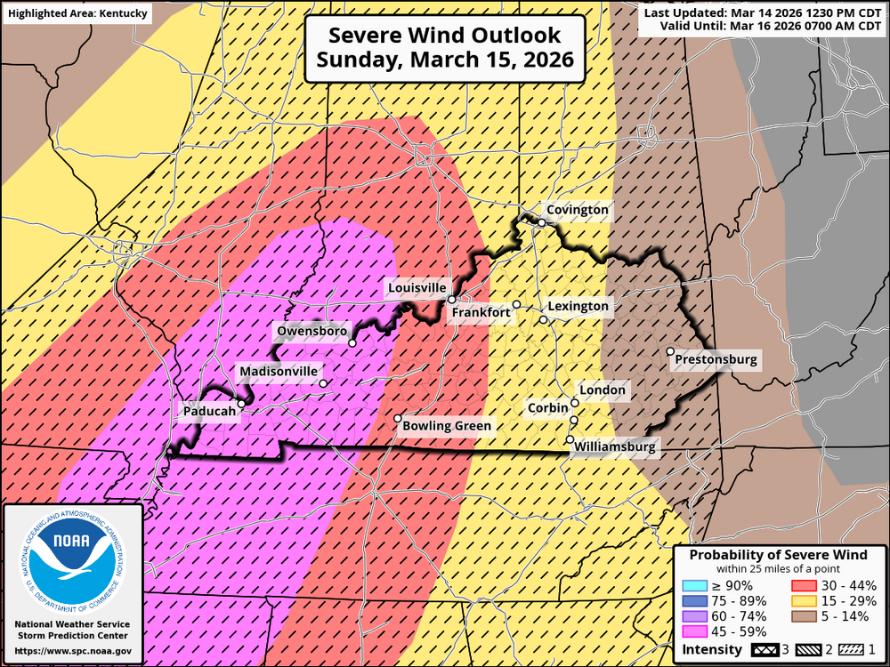
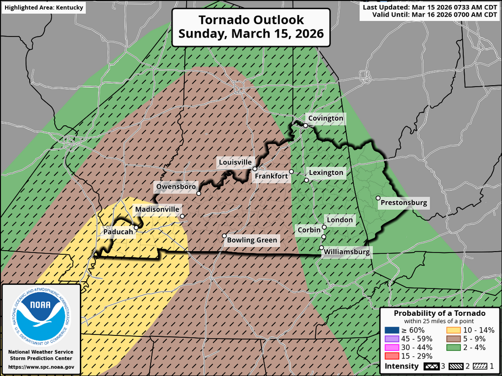
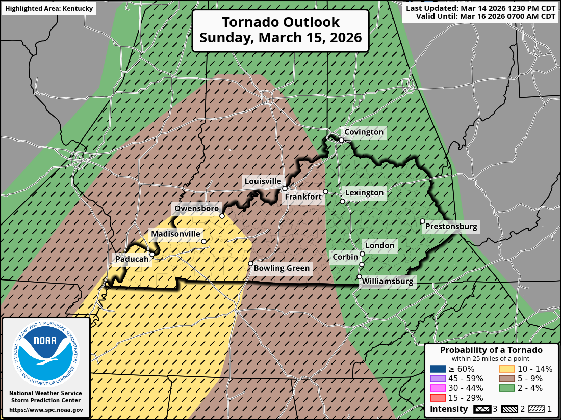
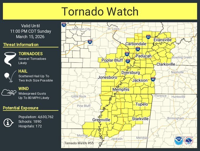 Update from the NWS-Louisville office:The Storm Prediction Center just sent these out. There is now a 15% chance that a tornado could form in western Kentucky. If one does, it is expected that the maximum intensity be EF2+. They could be weaker or stronger.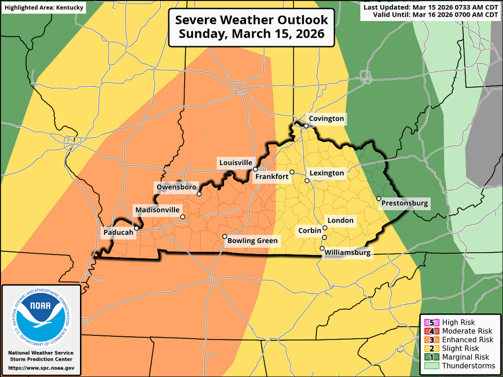
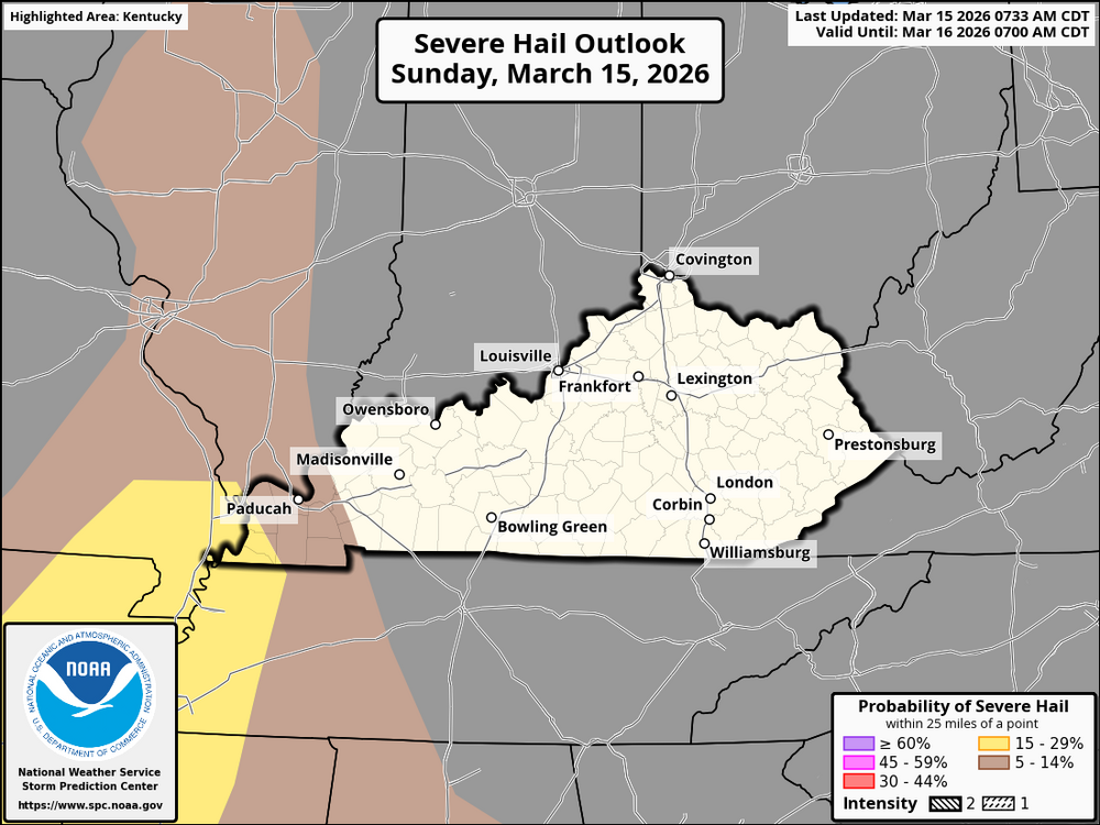
 An upper-level trough will gradually deepen and become negatively tilted. Between 5 and 6 p.m. EDT, a jet streak of about 65-100 kts will pass through the trough's entrance region. Around this time, the jet streak will enter the exit region, causing dew points to reach the 60s. This will allow strong to severe storms to develop in western Kentucky. Individual cells begin to form during this time, as visible on the HRRR radar. These individual cells are worth keeping an eye on because they will be in an area with potentially favorable tornadogenesis conditions. The individual storms will congeal into a line of storms around 10 pm EDT as the system moves into areas less conducive for tornado development. At this time it will become more of a damaging wind event.
.thumb.png.294a98712997bc01f32f9b3d8f3e19a2.png)
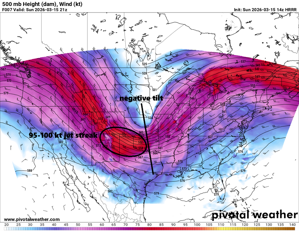
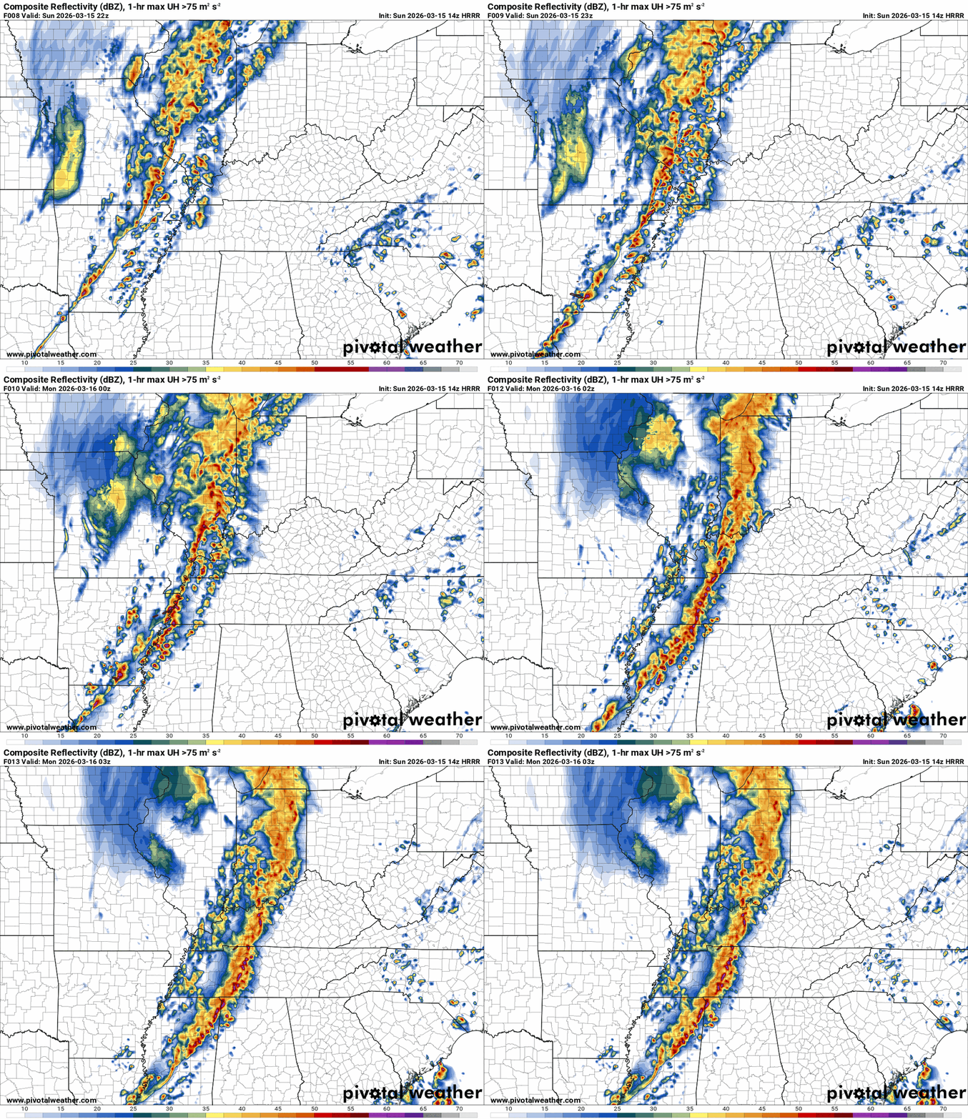
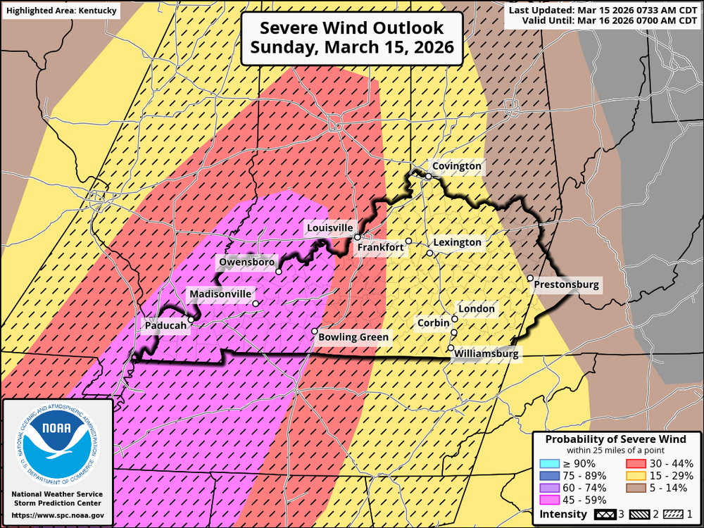
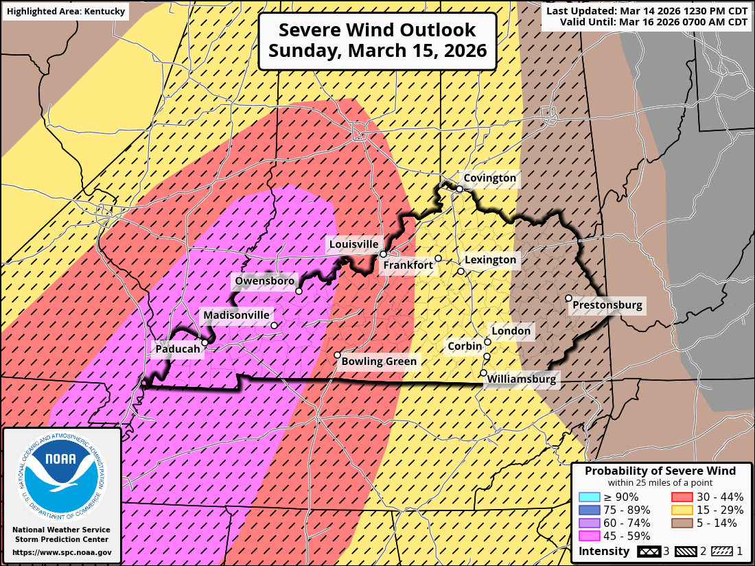
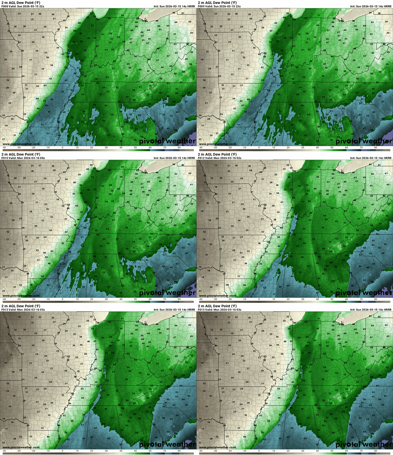 According to the most recent model projections, Kentucky and the Cincinnati area are expected to face a considerable risk of severe weather later today. A strengthening surface cyclone is set to move northeast, accompanied by the 850 mb jet streak, which will mainly influence the lower Great Lakes region by the afternoon. A robust southerly flow, reaching speeds of 40-50 knots, will extend across the Mid-South and into parts of Kentucky and Tennessee, facilitating moisture return as surface dew points rise into the low 60s Fahrenheit. In the Ohio Valley, prefrontal moisture is anticipated to be somewhat sparse, resulting in modest CAPE values. Nevertheless, this drier environment prior to convection might allow for stronger winds to be mixed down to the surface, potentially exceeding the wind speeds generated by thunderstorms. There is still a chance of wind gusts surpassing 60 mph, particularly with the formation of a pre-frontal squall line that will progress eastward through the Mississippi Valley and into the lower Ohio Valley. Late afternoon into evening presents an opportunity for discrete supercell development, especially in western Kentucky as the squall line moves forward. If such development occurs, the likelihood of stronger tornadoes increases. However, the overall tornado risk may be limited to meso-vortices (a small, intense whirl of rotating air that can form within larger storm systems, such as squall lines) along the front edge of the squall line, particularly in the more humid regions of the lower Ohio Valley and Mid-South. Be prepared for substantial wind gusts and potentially damaging storms, especially from late afternoon into the evening, with an elevated risk for tornadoes as the squall line continues to evolve and advance eastward. Stay informed with the latest weather alerts throughout the day. The period covered by the following maps is from 7 pm EDT Sunday to 8 am EDT Monday.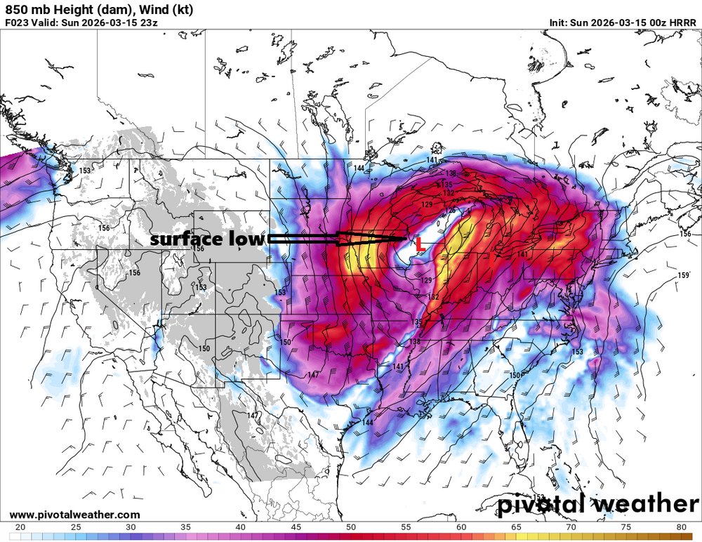
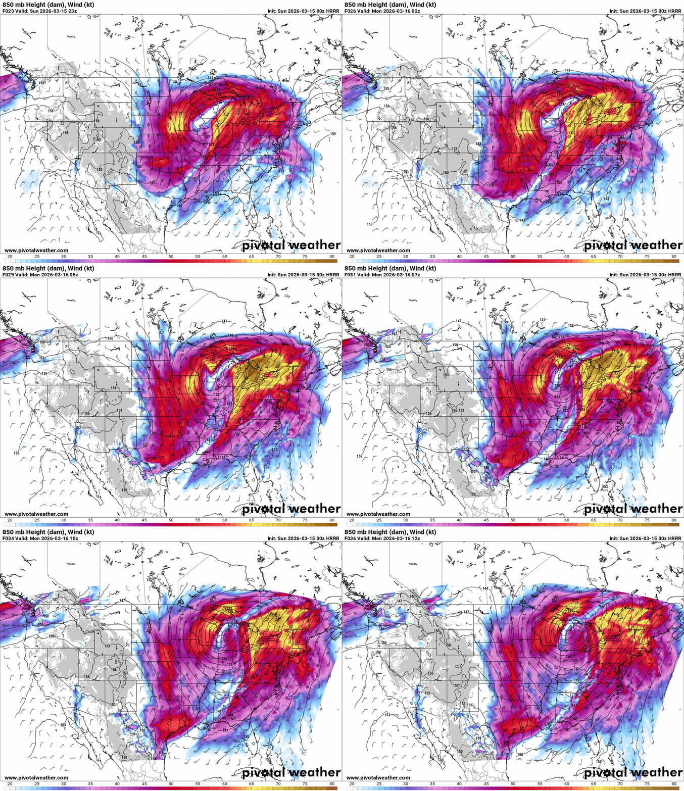
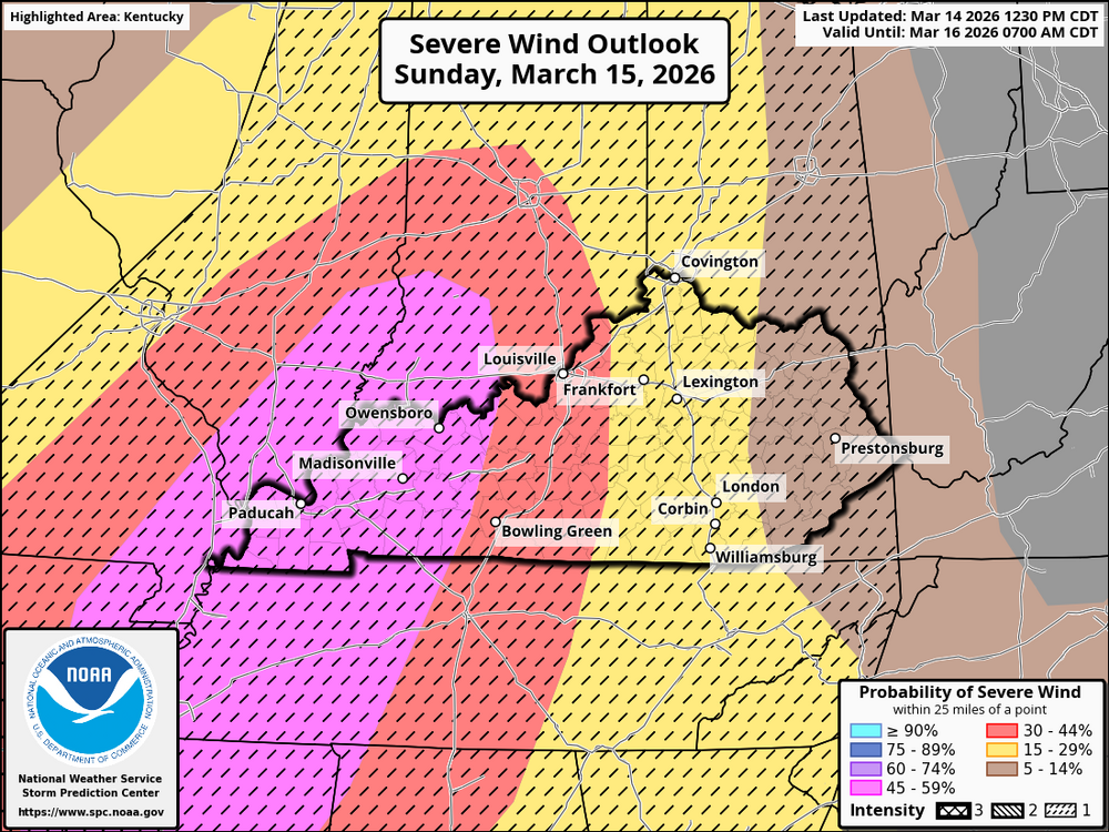
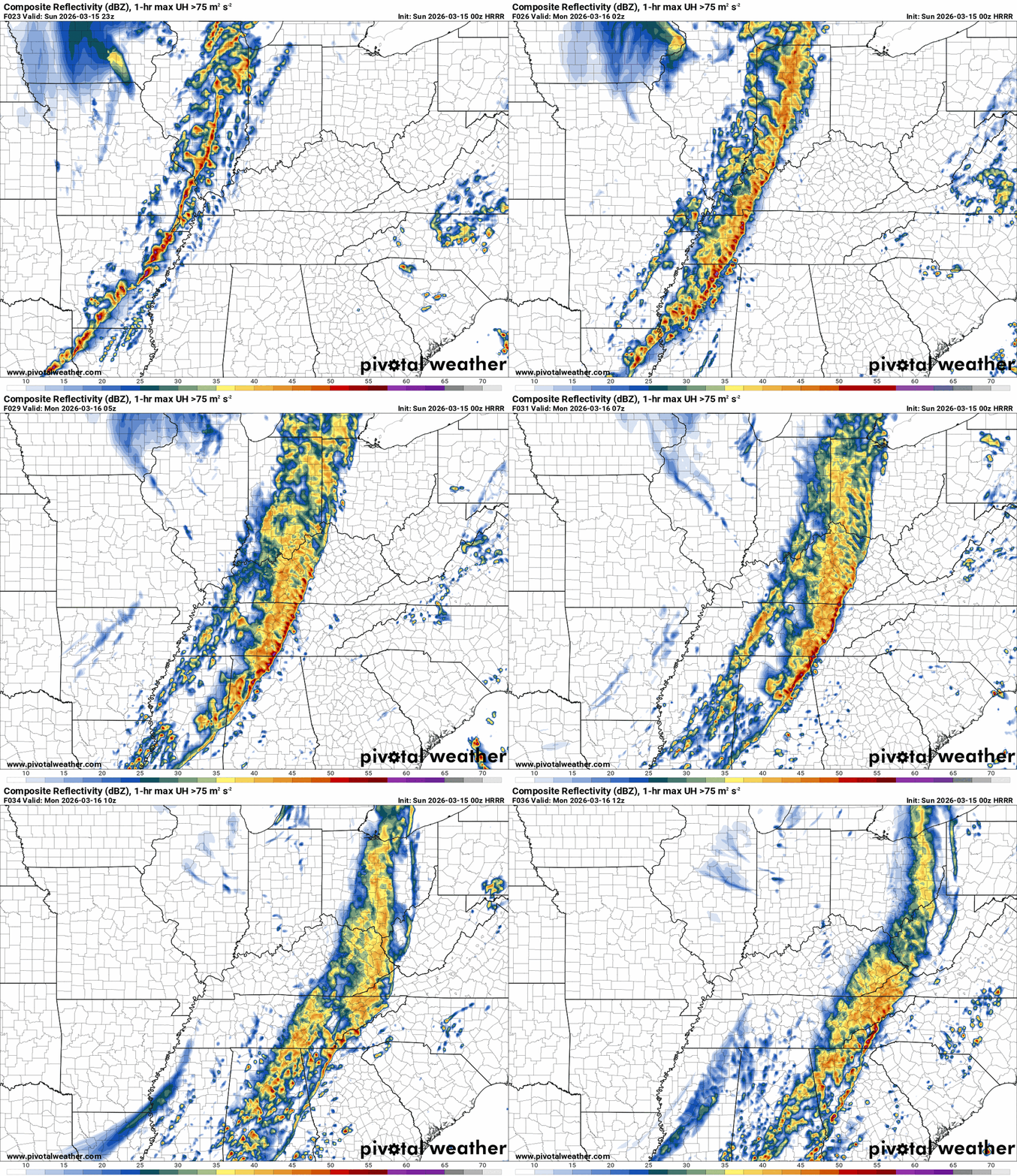 @theguruI'm going to go ahead and make Sunday a BGP Severe Weather Alert Day. This will happen at night, and the threat level is rising. The tornado threat for western Kentucky has gone up to about 15% with a CIG 1 intensity level. This means that a tornado that forms could be as strong as EF2+ or more. This area includes the cities of Murray, Paducah, Owensboro, and Bowling Green. There is a 10% chance of this happening in the brown area and a 2% chance of it happening in the green area. The threat of damaging winds has also increased. In the pink area, there is a 45% chance of damaging winds with gusts up to 74 mph. In the orange area, a 30% chance, and in the yellow, a 15% chance.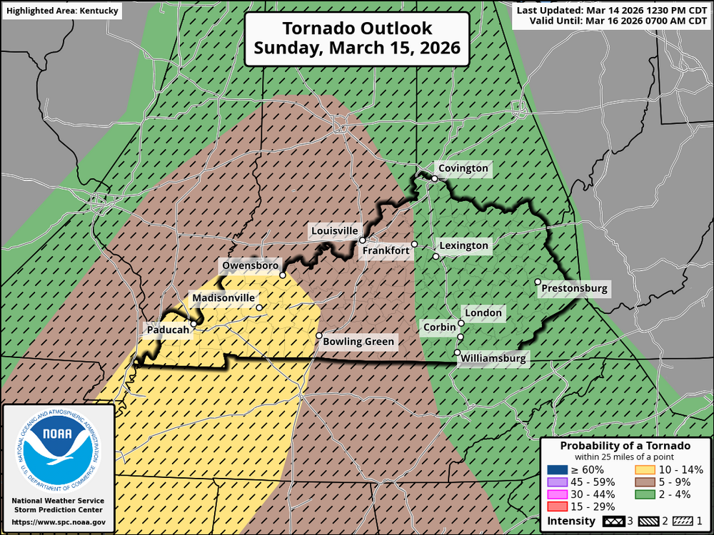









.png.18de05829abf6ed576379dc01f080063.png)


Account
Navigation
Search
Configure browser push notifications
Chrome (Android)
- Tap the lock icon next to the address bar.
- Tap Permissions → Notifications.
- Adjust your preference.
Chrome (Desktop)
- Click the padlock icon in the address bar.
- Select Site settings.
- Find Notifications and adjust your preference.
Safari (iOS 16.4+)
- Ensure the site is installed via Add to Home Screen.
- Open Settings App → Notifications.
- Find your app name and adjust your preference.
Safari (macOS)
- Go to Safari → Preferences.
- Click the Websites tab.
- Select Notifications in the sidebar.
- Find this website and adjust your preference.
Edge (Android)
- Tap the lock icon next to the address bar.
- Tap Permissions.
- Find Notifications and adjust your preference.
Edge (Desktop)
- Click the padlock icon in the address bar.
- Click Permissions for this site.
- Find Notifications and adjust your preference.
Firefox (Android)
- Go to Settings → Site permissions.
- Tap Notifications.
- Find this site in the list and adjust your preference.
Firefox (Desktop)
- Open Firefox Settings.
- Search for Notifications.
- Find this site in the list and adjust your preference.