
swamprat
Administrator
-
Joined
-
Last visited
Everything posted by swamprat
-
If that report was true, that is terrible because Tropicana Field is a shelter and base camp for relief workers.
-
Heard a report that the top just got ripped off of Tropicana Field.
-
I left my anemometer at my old place, which happens to be next to my sister's house. I looked and would have to hack into the new owner's WIFI to read it, if he left it up. Oh well. We are still getting high wind gusts, but the constant jet engine roar is not as bad now, or I am getting used to it. However, there are less things hitting the house and storm shutters. Not out of the woods, yet.
-
FWIW, I am not in the family room. I am in the formal dinning room.
-
I moved Mrs. S into our bedroom here. This is really no interior room in this house, but the noise is less in our bedroom with the storm shutters up. The fireplace and skylights in the family room make the whole thing sound much worse. My fear is loss of power. Mrs. S is on 2 liters of oxygen all the time now. I have a portable concentrator and a tank, though. If we loose power, I will have to put her on the portable until it goes dead, then put her on the tank while I charge the concentrator in the truck. We don't have a generator, I'm afraid.
-
It's made landfall at Siesta Key. Now the fun really starts.
-
For some reason, we still have power her at my sister's place. TECO is not reporting that many outages at this time. Duke Energy and Florida Power are reporting more outages south of the storm.
-
I lost access to my cameras at my home an hour or so ago. Some people who elected to stay, texted me with the information I relayed above.
-
The problem is the wind and rain. We are getting some pretty mean gusts right now. I don't know what the sustained winds are at the moment, but it sounds like a jet going overhead constantly. Things are hitting the house. Think of the worst rain storm you've ever been in and then imagine it lasting for the last 5 hours with no letup. Meanwhile where I my home is, the power is out, the lake in the park has overflowed, and there is water backing up in the streets. This is 52 feet above sea level, so this is not storm surge. That is how much rain we are getting in a short period of time. And the eye it is still off the coast.
-
Getting nasty out there.
-
Tampa General Hospital is a 1000 bed Level 1 Trauma hospital located on the tip of Davis Island in downtown Tampa. TGH has deployed their AquaFence and does not plan to evacuate patients or staff off premises. They are moving patients and staff from 1st floor up, though. The AquaFence performed well 2 weeks ago when Helene went through, holding off 7 foot storm surge. It is designed to hold off a 15 foot storm surge, so the test is coming. They have their own well and water storage facility in case the city water system fails. They have their own power station that is also separate from the main power grid. It is housed in a facility adjacent to the hospital and the station itself, is 33 feet above sea level. My sister is a nurse in Bay Care's ICU e-care facility in the Bay Care Operations center. My niece took her to work this morning. Sis will stay at the BCO until the storm has passed and all emergency services are no longer needed. My daughter is evacuating to her in-laws. My son is staying hunkered down with my grandson in Apopka, and my granddaughter is assisting my daughter-in-law at a shelter in Sanford, an elementary school she is principle of.
-
-
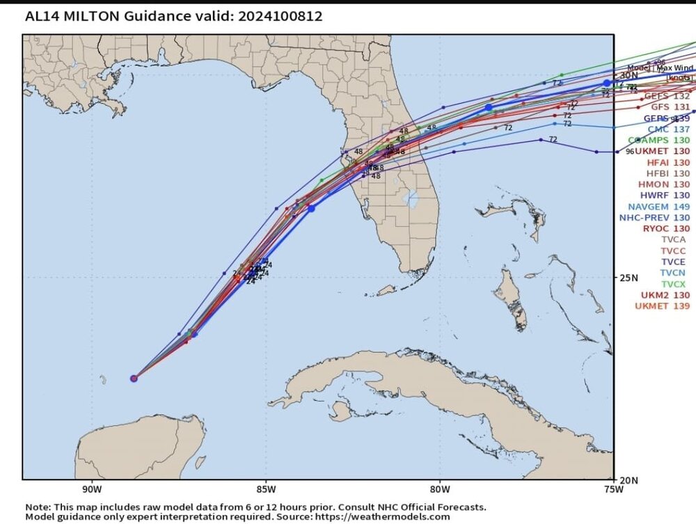
Here is what Dennis posted regarding the models. Back to loading the truck.
-
From Dennis Phillips (Chief Meteorologist at WFTS-TV in Tampa Bay.) Important Milton Update: (We've got some stuff to cover here folks, strap in!) 1. Ok, here is the latest. As you can see, we are starting to get some agreement on the models. (Finally). They show landfall from the Skyway to the Southern end of Manatee County. The NHC track pretty much mirrors this. That being said, most Floridians know "wobbles" are 100% unpredictable. No model (or human) can actually predict where they occur. However, most Floridians know those wobbles often are East of the center and have a tendency to go the the right. We've seen it SO many times before. (Charley, Irma, Ian, Idalia, and even Helene 2 weeks ago) 2. Hurricane winds will likely extend about 50 miles from the eye when it approaches our area. Right now, hurricane winds extend 30 miles from the center. Milton will get bigger over the next 36 hours. It's currently experiencing an ERC (Eyewall Replacement Cycle) which temporarily weakens the storm. That's why the winds are down. Once complete, it's certainly possible Milton can strengthen again. Although, I DO NOT expect it to regain its strength from yesterday. That's just my opinion. Could it? Sure. But I don't think it happens for a number of reasons. Either way, Milton WILL be a powerful hurricane when it impacts our area. For the record, the NHC now has it as a Cat THREE hurricane at landfall. That's lower than yesterday which is great news! 3. Surge is still a MASSIVE concern. Highest surge totals will be at, and just to the South of the point of landfall. So a Manatee County surge would limit the height of the surge in Pinellas and the Bay. However, just a small tick to the North and those areas would be right in the thick of it. If you're in an evacuation zone, DO SO. No mincing words here. People who live along the coast and do not evacuate are risking their lives. The threat of wind is MUCH lower than the threat of water with this (and most storms). 4. Let's talk about winds. In my opinion. most of the area will see winds between 65 and 90 mph. VERY strong winds. Power outages will be widespread. Trees will fall. Some roofs will have issues as well. Lots of blue tarps are expected in the coming weeks. However, the extreme winds will be in a very small area. I'm talking 5 to 7 miles. They will probably occur near the eye and in the NORTHERN eyewall. Shear IS going to weaken Milton. The storm will look cut in half at landfall. However, the Northern eyewall, which will be over Pinellas and Hillsborough counties, will contain extreme wind gusts. Not sustained, but gusts to nearly 100 mph. This is something we will watch very closely. A change or wobble in track could easily move this band 20 miles North or South. Again, this is unpredictable and why it's important to keep following us here as well as on ABC Action News - WFTS - Tampa Bay Once the storm moves inland, areas in Polk and Desoto counties will also see hurricane-force wind gusts. I suspect they even reach Orlando as well. 5. I have posted and will post again, a great list of things to have ready as the storm nears. You still have ALL DAY today and tomorrow morning to get things done. The strongest winds don't arrive until Wednesday evening and overnight. 6. Rule #7. Now it NOT the time to freak out. It's the time for action. We have work to do to protect our families. We have work to do to protect our neighbors, our friends, our community. The stress level is massive. You CAN do this. We still have a day and a half to get ready for Milton. Floridians are strongest when things get the worst. We WILL get through this. And we will do it, TOGETHER. Updates 24/7. 7. As for colleges and universities, if kids are still planning on coming home today, expect massive delays on the roads. Take that into consideration if you're planning on having your kids leave school to go home. Florida State University and Florida A&M University will be fine. University of Florida should be fine as well. University of South Florida, The University of Tampa, and University of Central Florida will all experience hurricane-force wind gusts. UT will also have a significant surge risk. Do NOT let your kids stay if they are in a mandatory flood zone along the river. At this point, Florida Gulf Coast University is on the fringe of the heavy winds but a track change could change that. Make sure they stay vigilant. #FloridaStrong
-
My daughter-in-law is a principle of an elementary school in Sanford. It will server as a storm shelter for that area. She and my granddaughter (that baby I was holding almost 17 years ago) will be working the storm there.
-
FWIW, my home is not in any flood zone, so storm surge is not a factor. However, it is a manufactured home in a retirement community and very susceptible to wind damage. I expect many insurance companies in this area to go bankrupt before they get to me. There is no point in getting scared all bent out of shape about it at this point. Just need to get Mrs. S to safety, hope for the best, and make due with whatever happens.
-
From Pinellas Count Emergency Information site... Pinellas County is in the potential path of Hurricane Milton and could experience life-threatening storm surge, localized flooding and hurricane force winds, depending on where the storm makes landfall on Wednesday. Pinellas County has issued a mandatory evacuation order for everyone in Zone A, B and C, and all mobile homes. Earlier the County announced evacuations for special needs residents and residential health care facilities in these zones. Check your evacuation zone. Mandatory evacuations for special needs residents is underway. Six public shelters are open, including shelters for people with special needs or pets
-
Storm shutters are up at my sister's place. I took most of our perishable food over there Yesterday. Traffic was horrendous going north today. US19, the Suncoast Parkway, I-275, I-75, US41, and US301 all jammed up. I took the BaySide bridge up to FL580 to get to my sister's to avoid the traffic and an 45 minute drive took me over 2 hours. Tomorrow may be worse. Thorton's has boarded up all of their stations. Shell, WaWa's, Mobile, Circle K, and 7-11 are still open, but the lines are backed up on to the roadways. The RaceTracks and Speedway's I went by on my way home today were all out of gas. I know at least one WaWa's is out of gas. There is not much else to do here, but get clothes, drugs, and important papers together. We will pack up Mrs. S's concentrator, pillows, and all else and head over to my sister's place tomorrow afternoon. I also took all of my Ryobi tools to my sister's. I have a feeling I'm going to need all of them here in the next week.
-
Notification from Pinellas County Emergency Information ... Pinellas County has issued an evacuation order for all residential healthcare facilities within Zone A, B and C. The mandatory orders are only for these facilities, but Pinellas County is encouraging voluntary evacuation for residents in Zone A, B and C and mobile homes in advance of possible mandatory orders Monday. Otherwise, everything is business as usual around here. I took Mrs. S to an imaging center adjacent to Morton Plant hospital this morning for a PET scan. Although the hospital is getting ready for evacuation, there was not noticeable increase in activity. Evacuation of Bay Pines VA hospital started yesterday and should be completed by sometime this afternoon. The patients are being sent to other VA hospitals outside the cone or where the storm will be of lesser strength, mostly to Orlando, Ocala, and Palm Beach. Our plan is to go to my sister's place tomorrow evening. I am going there today to finish putting up her storm shutters.
-
Hurricane prep.
-
Dennis Phillips is saying it now looks like the eye may come in south of Tampa Bay and hurricane force winds may only extend 10 miles from the center. It may be powerful, but it looks like it is going to be compact. And it will be moving fast when it hits the coast. The eye going south is a good thing for where we live. The storm surge is on the south side of the storm. Any direct hit on Pinellas County will be devastating. We will definitely be evacuating to my sister's place. I've pretty much resigned myself to the fact that if we get a direct hit. My place will be gone when I get home. The beaches cannot take another storm. From Pass-A-Grill to Tarpon Springs, the damage done from the storm surge of Debby is amazingly bad. They are talking as much as a decade to recover from Debby. Now here comes something worse.
-
The teams I follow in Florida. Class 4 Region 3 District 10 Clearwater 48 Tampa Catholic 14 Mitchell 38 River Ridge 21 Gulf 26 Sunlake 15 The rest ... Alonso 35 Steinbrenner 9 Clearwater Central Catholic 42 Northside Christian 7 Pinellas Park 34 Tarpon Springs 21 Spoto 48 Freedom (Tampa) 7 St. John Neumann 17 Indian Rocks Christian 7 Berkeley Prep 45 Bloomindale 7 Oscelola (Seminole) 20 Seminole (Seminole) 12 Calvary Christian 41 Trinity Catholic 13 University (Orange Grove) 35 Jesuit 33
-
The teams I follow in Florida. Class 4 Region 3 District 10 Clearwater 41 Gulf 21 River Ridge 63 Countryside 0. The rest... West Orange 25 Apopka 7 Calvary Christian 28 Berkeley Prep 23 Clearwater Central Catholic 42 Indian Rocks Christian 0 Palm Harbor University 15 Largo 13
-
Final. Clearwater 41 Gulf 21.
-
TD Clearwater. 2:30 left. 41-21 Tornadoes.