.png.ffa34568722b20f38e3c3ecfcb9a2cd2.png)


nWo
-
Posts
25,569 -
Joined
-
Last visited
-
Days Won
1
5 Followers

Recent Profile Visitors
16,178 profile views


-
I would favor having western Kentucky added to the Enhanced Area. There is a remote possibility that it could become a level 4 Moderate Risk. I recently examined the most recent HRRR for the significant tornado parameter. Right now, it is at 5.5 out of 10. Most large tornadoes of F2 or higher have been linked to STP values greater than 1. Now, this does not imply that one will occur; rather, it indicates that the right circumstances exist for large tornadoes to form.
- 1 reply
-
- 1
-

-
There is currently a severe threat over the region that is multifaceted and multi-episode. First, there was a continuous band of strong to isolated severe thunderstorms that could be seen over parts of northern Arkansas, southwestward over southeastern Missouri, and across areas of Illinois. The bigger worry is that thunderstorms that are expected to form this afternoon along or ahead of the cold front may subsequently impact on a warm, moist airflow corridor that is behind the morning's activity and provides favorable heating. Under a plume of steepening midlevel lapse rates, which is a remnant of somewhat modified dry air above and extending across the area of low-level destabilization, surface dewpoints should rebound into the mid-upper 60s F. Conditions suitable for supercells to form and remain relatively distinct should result from the superposition of these processes; hodographs (Sounding Analogs) in the lowest several kilometers appear favorable for tornadoes (some possibly strong).

-
From sections of the southern Plains into the mid-Mississippi, Ohio, and Tennessee Valleys, scattered to numerous severe thunderstorms are likely on Wednesday. There should be all of the severe risks, such as tornadoes, large hail, and damaging winds. There may be strong tornadoes among them. The northern extension of the more severe probabilities has been somewhat reduced in this area, based on the most recent guidance trends that indicate the warm front stalling or not moving as much northward into the Ohio Valley. If not, very large hail is likely, with the first clusters developing along the warm and cold fronts. This could happen across Missouri as early as mid-morning on Wednesday. By early Wednesday afternoon, more supercell development may also happen along or near the warm front, spanning portions of the mid-MS Valley and into the lower OH Valley. With enough 0–1 km shear to sustain low-level updraft rotation, there is also a risk of tornadoes with this warm-frontal activity in addition to the very large hail hazard. Considering the prediction, several of these tornadoes may be strong. An increasing threat for severe/damaging winds is also apparent through the late afternoon, and likely continues into at least the early evening, as convection should attempt to grow upscale into one or more intense bowing clusters. With that said, convective evolution is somewhat uncertain, and attempting to pinpoint areas of greater severe wind potential remains difficult. Given this forecast, the Storm Prediction Center now has almost the entire state of Kentucky under a level 3 Enhance Risk Area. For now the greatest tornado threat is west of I-75 and south of I-64. Remember, though that any severe weather mode will be possible in a level 3 area.
-
The very latest is showing even if we get morning storms, we could still have a problem.
-
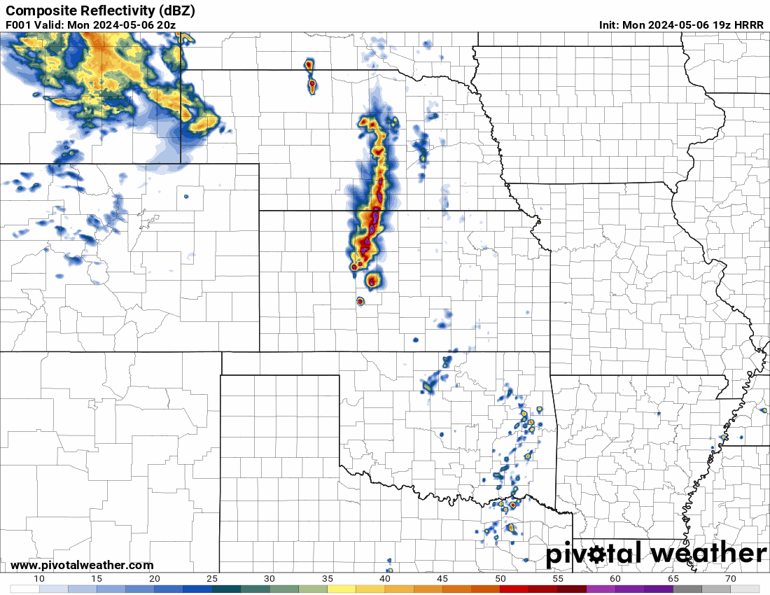
Here is what the very latest HRRR is showing for today. Remnants of the storms that tore through the Plain States should enter western Kentucky around 9 am EDT. Some could still be strong to severe, with a possibility of producing a tornado. Given the conditions forecast for later today, any individual storm that pops up could become supercellular and produce damaging winds, hail, and a possible tornado. This threat will be present throughout the day. Around 4 pm EDT things should start to really pop. Individual storms should start forming. Everyone across the state should be weather aware. The threat will continue into the early morning hours on Wednesday. Then we will be going through a severe weather threat again during the day on Wednesday. All severe weather modes will be possible today.
-
-
 nWo changed their profile photo
 -
As I predicted yesterday, the threat level has increased in most of Indiana, western and southwestern Ohio, and a section of Kentucky. ..THERE IS AN ENHANCED RISK OF SEVERE THUNDERSTORMS ACROSS THE OHIO VALLEY... Throughout the Ohio Valley, sporadic severe thunderstorms are predicted for today. It looks conceivable that there may be a few tornadoes, high winds, large to extremely large hail, and severe or destructive winds. According to current models, convection related to this trough will continue and move into the middle of the Mississippi Valley by daybreak. After that, it will go downstream and maybe diminish in the morning. But following this initial activity, boundary-layer heating will produce an air mass that is moderate to extremely unstable by early afternoon. As temperatures rise into the 70s and almost 80F, convective temperatures should be easily broken, and isolated to scattered thunderstorms should develop around the southern edge of the main jet stream. Forecast soundings over the Ohio Valley show suitable shear/buoyancy for supercells. Storms that develop in this kind of setting will probably stay isolated or maybe form some kind of cluster. Large hail and a few severe tornadoes are possible. In addition, damaging winds are possible.
-
This is his set up
-
Here's what the HRRR is showing. The first one is precipitation. The second one shows the lightning. It looks like some of these storms will be quite intense.
-
For Tuesday, the level of severe threat has been increased to level 3 Enhanced Risk in eastern Indiana, western Ohio, and central Ohio. In further updates, it would not surprise me if the Enhanced area was extended to encompass parts of Kentucky and southeast Indiana.
-
Not counting the major weather networks, who or how do you watch a severe weather event? There are several on YouTube. You can watch the one you choose on your mobile device even if you lose power in your home or business. My daughter told me she watches him too. I normally watch Kentucky's own Ryan Hall. He lives in Pikeville, Kentucky, I think. https://www.youtube.com/@RyanHallYallXTRA
-
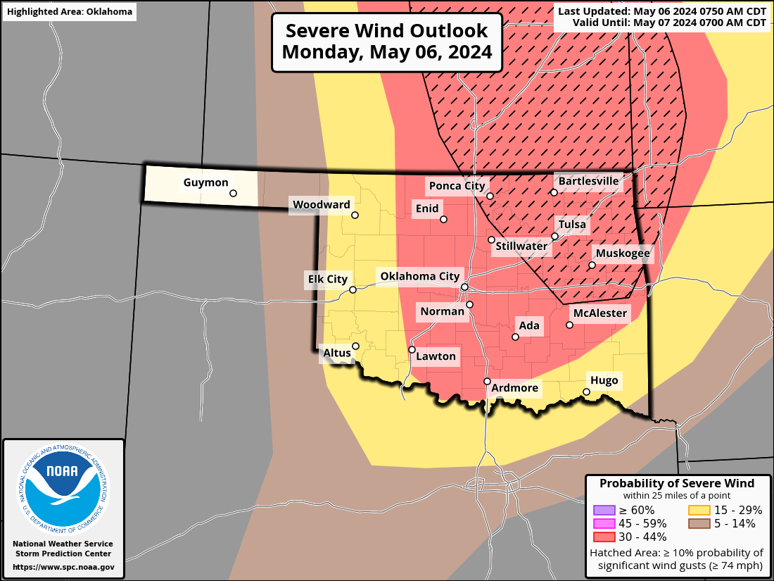
ZCZC SPCPWOSPC ALL WOUS40 KWNS 061324 KSZ000-OKZ000-061800- PUBLIC SEVERE WEATHER OUTLOOK NWS STORM PREDICTION CENTER NORMAN OK 0824 AM CDT MON MAY 06 2024 ...Outbreak of tornadoes and severe thunderstorms expected over parts of the central and southern Plains this afternoon and tonight... * LOCATIONS... Much of Oklahoma Central and eastern Kansas * HAZARDS... Numerous tornadoes, several intense and long track Widespread large hail, some baseball size Scattered damaging winds, some hurricane force * SUMMARY... A regional outbreak of severe weather with multiple strong, long-tracked tornadoes, as well as very large hail and severe thunderstorm gusts, is expected over parts of the south-central Plains from this afternoon through evening. Preparedness actions... Review your severe weather safety procedures for the possibility of dangerous weather today. Stay tuned to NOAA Weather Radio, weather.gov, or other media for watches and warnings. A tornado watch means that conditions are favorable for tornadoes to form during the next several hours. If a tornado warning is issued for your area, move to a place of safety, ideally in a basement or interior room on the lowest floor of a sturdy building.
-
I neglected to mention that the High Risk Area is at level 5 out of 5. The highest threat there is.
-
I worry that Oklahoma could suffer catastrophic destruction and perhaps lose some lives today. From this afternoon through this evening, areas of the south-central Plains are predicted to experience a regional outbreak of severe weather that could include several powerful, long-tracked tornadoes, very big hail, and significant thunderstorm gusts. The CSU-MLP map illustrates this. I will use this new data to forecast the likelihood of the various severe weather modes. In the High Risk Area, there is a 30-45% risk of tornadoes. a 45–60% probability of hail. Additionally, there is a 30-45% probability of damaging winds.
-
I know, and the threat level may be raised again. If the modeling guidance continues to show it is needed.