.png.ffa34568722b20f38e3c3ecfcb9a2cd2.png)


nWo
-
Posts
25,554 -
Joined
-
Last visited
-
Days Won
1
5 Followers

Recent Profile Visitors
15,959 profile views


-
I just received this from the NWS-Louisville office: The slide map is from the Storm Prediction Center. The categorical maps are the same as the ones I posted earlier.
-
 nWo changed their profile photo
 -
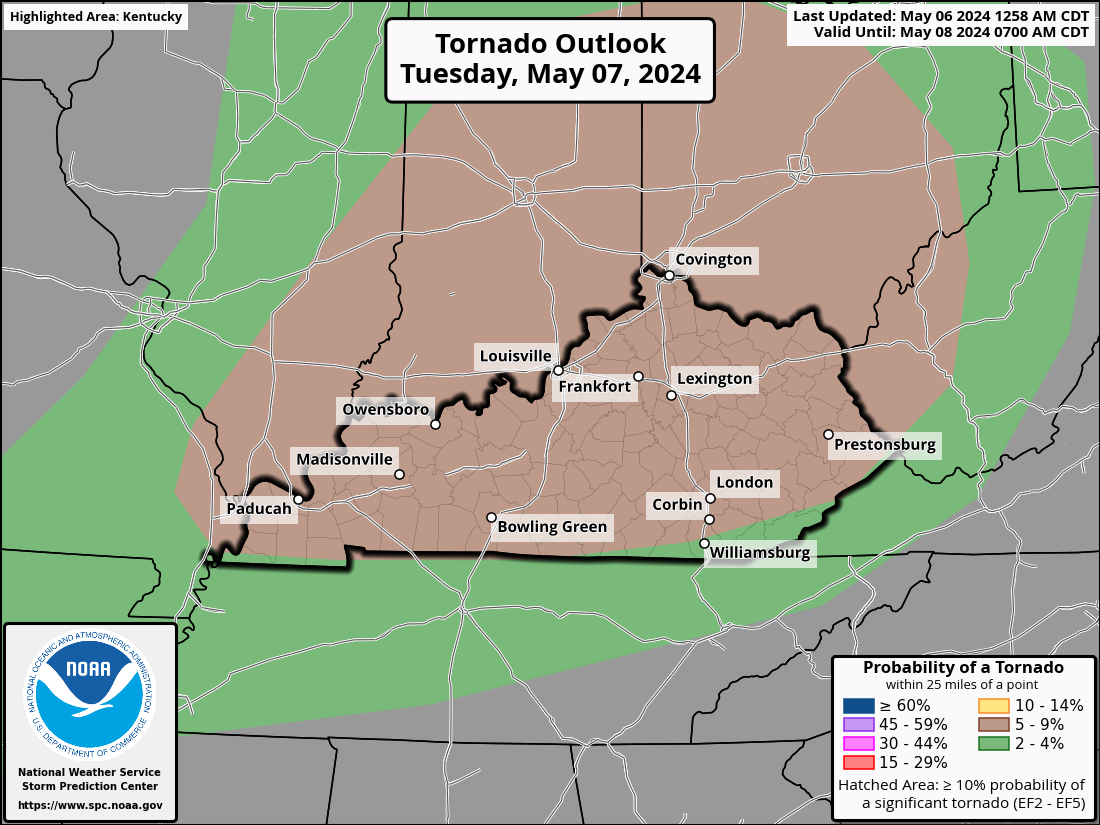
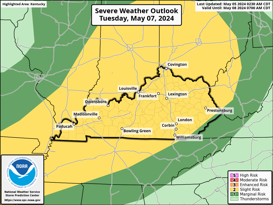
The threat level for severe weather has increased to level 3 Enhanced Risk, as I had predicted. There is a chance of scattered to numerous severe thunderstorms on Wednesday, extending from areas of the southern Plains into the Tennessee, Ohio, and mid-Mississippi Valleys. There should be all of the extreme risks, such as tornadoes, enormous hail, and strong or destructive winds. There might be some powerful tornadoes. Very big hail will be a worry with early supercells, and severe/damaging winds will probably become a bigger concern as intense convection moves east-southeastward during the afternoon and evening, even if convective evolution is still somewhat unknown. Throughout the day, a moderate to strong low-level jet is expected to move eastward across the mid-MS and OH Valleys, supporting increased low-level shear, particularly close to the warm front. In this ideal shear environment, supercells will raise the risk of tornadoes. Because of the favorable thermodynamic and kinematic conditions, some of these tornadoes may be strong until at least Wednesday night.

-
On Tuesday, there is a chance of isolated, strong thunderstorms moving northeast from the Mid-South and into the Ohio Valley. big to extremely big hail, severe/damaging winds, and a few tornadoes are likely. The possibility of a more serious threat is complicated by the impact of early-morning convection. However, it is likely that there will be regeneration along the leading edge and/or outflow of the early convection throughout Tuesday afternoon. Supercells and multicell clusters may coexist in an overall mode that could be a little disorganized. In any case, large to extremely large hail should be produced by any persistent supercell. There is enough low-level shear linked to a 25–35 kt south-southwesterly low-level jet to sustain updraft rotation and pose a risk for a few tornadoes, mostly in the Ohio Valley. A higher risk of severe or destructive winds would arise if thunderstorms were able to cluster into one or more of these formations. On Tuesday night, this convection should move into the western regions of the central Appalachians before finally diminishing.
-
I really do not like what Wednesday's models are showing. Currently, there is a bigger risk than before. I fully expect sections of Kentucky to be designated as a Level 3 Enhance Risk Area if this pattern continues. The timing of the storms remains uncertain; however, there may be some discrete cell formation as well as an additional linear mode. Every severe weather scenario will be probable. We could expect dew points in the low to mid-70s. This could add fuel to the fire if tornadoes form. The period covered in the following maps is from Wednesday at 8 am to Thursday at 2 am.
-
Eastern Kentucky should have been rated as having a 30-45% chance.
-
Multiple rounds of storms, some of which could be strong to severe, will be possible in the Tuesday through early Thursday AM timeframe. Straight-line wind damage, hail, and tornadoes will be possible with severe thunderstorms. Confidence in the timing of these waves isn't particularly high, but the most impactful one will likely affect us Wednesday afternoon into early Thursday morning. The CSU-MLP map indicates that Wednesday appears to be the greatest day for significant storm activity. There is a 45–60% risk of storms over most of Kentucky. Between Paducah and Louisville, there is a 60–70% chance of severe thunderstorms in this area of Kentucky. In Eastern Kentucky, the likelihood is 15–30%.
-
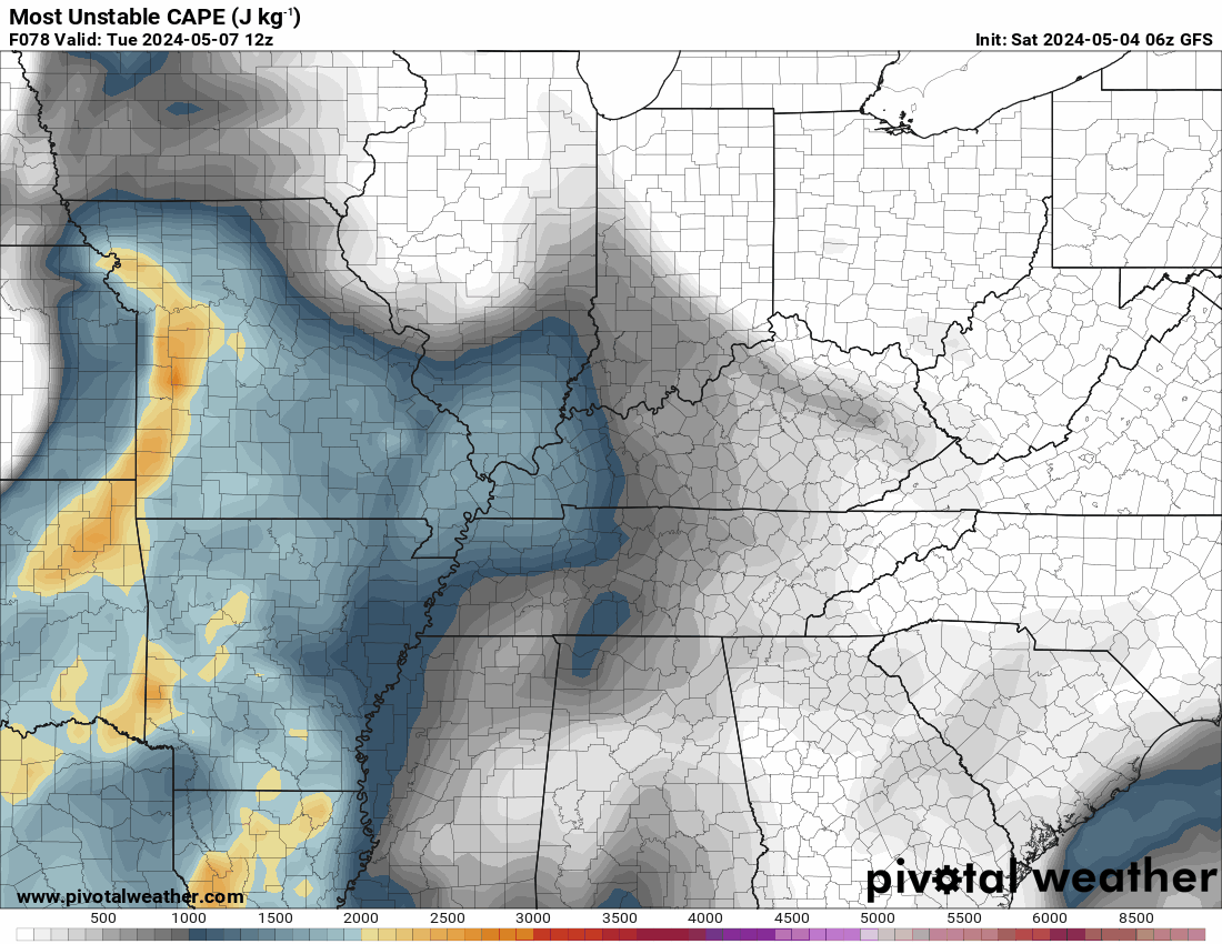
Due to convection that formed on Monday throughout the Plains, a line of thunderstorms is likely to continue Tuesday morning over portions of AR, MO, and IL. Nonetheless, this activity may tend to wane in the early hours. Nonetheless, it can still present a risk from sporadic strong or gusty winds. Greater instability is predicted across the Mid-South and lower OH Valley, with weak to moderate instability expected to develop ahead of and to the southwest of these early-day thunderstorms. It is predicted that organized convection, including some supercells, will be supported by deep-layer shear that is sufficiently powerful. With this knowledge, Kentucky is classified as a category 2 Slight Risk area by the Storm Prediction Center in its severe weather outlook for Tuesday. Their probability map has Kentucky in the 15–29% chance of severe storms. Next, I'm using the CSD-MLP maps, which are probabilistic forecasts of severe hazard occurrences initialized for Tuesday. The highest probabilities are for damaging winds and hail, both of which show a 15–30% chance of occurring. A large section of Kentucky has a .5–.10% chance of a tornado forming.
-
Around midweek, the elements are beginning to assemble for what might be a multi-day severe weather event. It is possible that Kentucky may experience severe weather beginning on Tuesday and continuing intermittently until Thursday night. I want to display the mid-level winds (about 18,000 feet) first. The winds at this altitude are represented by the purple hues. The wind speed increases with the depth of color. This will enable moisture from the Pacific and the Gulf to be drawn into our region. The uplift will be along this trough's leading edge, which will facilitate the development of storms. Particularly on Wednesday, the dew points can be in the low seventies. The potential energy in the atmosphere for storm formation is displayed on the Must Unstable Cape map. That is, if convection occurs in those areas. The Storm Prediction Center has a 15% area in days 4 and 5 Convection Outlooks. This is equal to a level 2 Slight Risk condition. Tuesday Wednesday The Colorado State University Severe Probability Map is showing a 30% chance in the same area for day 4 from the Storm Prediction Center. This covers all of WKY and along the Ohio River area to the Cincinnati/NKY area. The day 5 map for Wednesday from CSU shows a 45% chance in the area the Storm Prediction Center shows a 15% chance. The Louisville This includes the same area as on Wednesday but is expanded eastward to include much of Kentucky except for EKY and SEKY. It is really almost impossible to show the precipitation map this early because we are still a little too far in the future. Check back for updates.
-
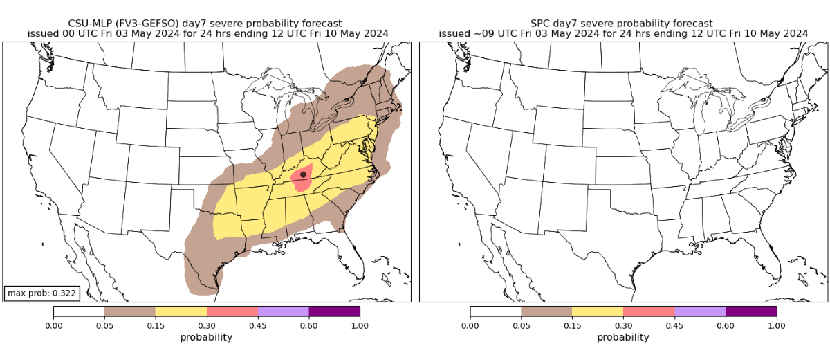
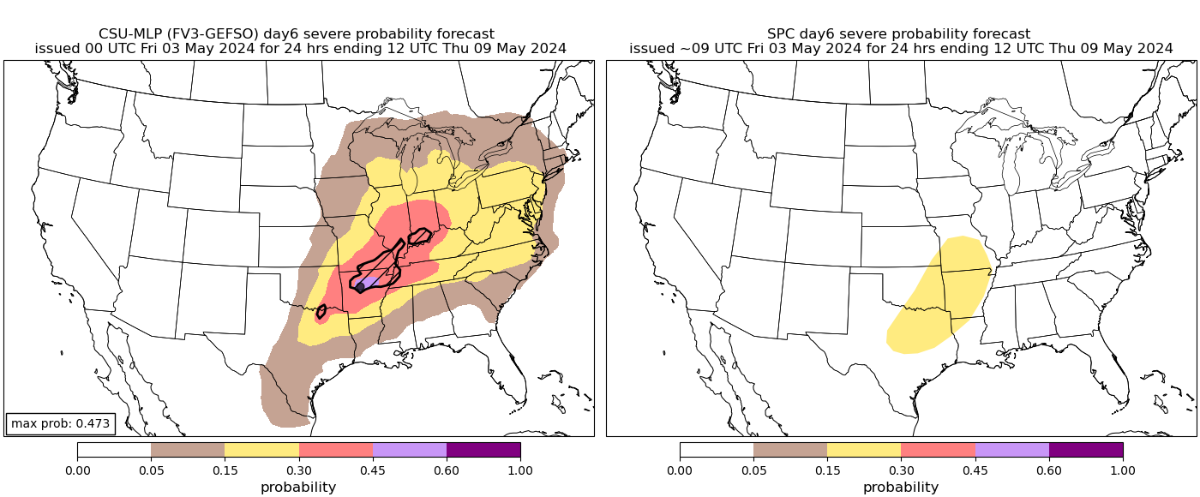
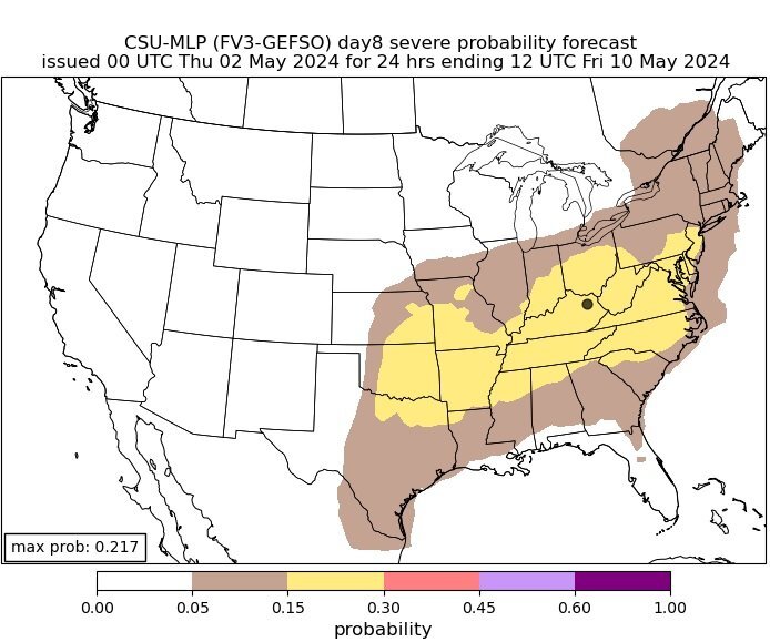
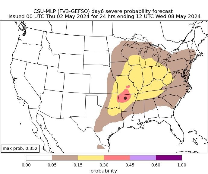
The most recent maps are available here. About a week remains till this potentially multi-day storm occurs. These are the predicted maps as of late. The Storm Prediction Center's maps of the likelihood of severe weather are placed next to them. Day 5 for Wednesday 5/8/24 Day 6 for Thursday 5/9/24 Day 7 5/10/24
-
We could see some severe weather in Kentucky starting around midweek. Right now, May 9th seems to be the best opportunity, as the bullseye is located in NKY. The Colorado State University MLP prediction page is where I got the forecast maps I am sharing. A week prior to the catastrophic weather outbreak of last week, this is what the page was displaying. You can see that it was largely accurate. This is what it is showing for possible severe weather in Kentucky next week starting on May 6th and continuing until the 8th. This is for Thursday, May 9th. Everyone can see the bullseye is centered in NKY. It is prediction a 30 to 45% chance for severe weather. This is pretty high this far in advance. I will be watching this possible situation and posting updates as we get closer.
-
At least one person was killed and several others were injured when a tornado tore through the community of Westmoreland in Kansas outside of Topeka on Tuesday, April 30, 2024
-
-
-
-