.png.ffa34568722b20f38e3c3ecfcb9a2cd2.png)

.jpg.dff87640c6ed93f4bdf8eebdf96f5dec.jpg)
nWo
-
Posts
25,628 -
Joined
-
Last visited
-
Days Won
5
Everything posted by nWo
-
Saturday is now in the range of the NAM model and it is also showing temps in the mid to upper 30s by 5 am Saturday morning with light showers early in the morning. A heavier batch of showers looks to move in around mid morning and lingering around most of the afternoon. Temps look to be in the low to mid 40s where the rain falls. The following simulated model runs only go to around 2 pm EDT. Check back for updates later.

-
Here's the first outlook for this weekend's Kentucky Derby. Saturday morning 5/6/17 Temps in the low to mid 30s little or no chance of showers 2 pm EDT Temps in the upper 40s to low 50s chance of light showers. Around post times temps look to be in the low upper 40s to low 50s with a chance of showers. I'll be posting more detailed updates as we get closer.
-
You're welcome.
-
Looks like all storms have dropped below severe levels. There may still be some strong ones out there so everyone be safe. I'm going to call it a night.
-
Weather warning are now being sent out through our twitter feed.
-
Parts of Kentucky mainly west of I-65 are in a Slight Risk Area for strong to severe storms today into tonight. This includes a risk for storms capable of producing tornadoes, a couple of which could be strong. The modeling data for now is showing the main threat being late this afternoon into the early evening hours the main storms the line of storms going through WKY. They should be in the I-65 corridor area around midnight. Around 2 am EDT the possible storms should reach the I-75 corridor. The storms look to weaken after the pass I-75. Be weather aware today. I'll probably not be able to update until later this evening.
-
Severe Thunderstorm warnings are being issued in areas of Kentucky not covered by this watch. Follow our twitter feed for the latest warnings.
-
URGENT - IMMEDIATE BROADCAST REQUESTED Severe Thunderstorm Watch Number 174 NWS Storm Prediction Center Norman OK 355 PM CDT Sat Apr 29 2017 The NWS Storm Prediction Center has issued a * Severe Thunderstorm Watch for portions of Southern Illinois Extreme Western Kentucky Southeast Missouri * Effective this Saturday afternoon and evening from 355 PM until 1000 PM CDT. * Primary threats include... Scattered damaging wind gusts to 70 mph possible Scattered large hail events to 1.5 inches in diameter possible A tornado or two possible SUMMARY...A line of storms is bowing eastward across east-central and southeast Missouri toward southern Illinois. It will pose a threat for damaging wind and possible hail as moves along and south of a warm front through the later afternoon and evening. The severe thunderstorm watch area is approximately along and 70 statute miles east and west of a line from 10 miles north of Mattoon IL to 35 miles southwest of Cape Girardeau MO. For a complete depiction of the watch see the associated watch outline update (WOUS64 KWNS WOU4). PRECAUTIONARY/PREPAREDNESS ACTIONS... REMEMBER...A Severe Thunderstorm Watch means conditions are favorable for severe thunderstorms in and close to the watch area. Persons in these areas should be on the lookout for threatening weather conditions and listen for later statements and possible warnings. Severe thunderstorms can and occasionally do produce tornadoes.
-
-
URGENT - IMMEDIATE BROADCAST REQUESTED Severe Thunderstorm Watch Number 170 NWS Storm Prediction Center Norman OK 810 PM EDT Fri Apr 28 2017 The NWS Storm Prediction Center has issued a * Severe Thunderstorm Watch for portions of Southeast Indiana Extreme north central Kentucky Southwest Ohio * Effective this Friday night and Saturday morning from 810 PM until 200 AM EDT. * Primary threats include... Isolated very large hail events to 2 inches in diameter possible Isolated damaging wind gusts to 70 mph possible SUMMARY...Clusters of slightly elevated storms, with some supercell structures, will likely persist and spread eastward from Indiana into Ohio through early tonight. The strongest storms will be capable of producing large hail and damaging winds.
-
Well there won't be much sleep tonight. Just got called in to work Saturday. Got to be there at 5 am.
-
I'm home now. I'm getting ready to take a break and eat something and run some quick errands. Looks like we're in for a long night.
-
This is what concerns me the most. The tornado threat will increase and move northward as the night goes on. 6-9 pm EDT 10 pm-1 am EDT
-
Simulated HRRR Radar for tonight. 5-9 pm EDT 10 pm-1 am EDT
-
Tornado Watch maybe issued soon.
-
Look for dew points to get to around 70 by early this evening.
-
For those who may want to sign up to follow our twitter weather feed. http://bluegrasspreps.com/bgp-break-room/bgp-com-weather-342822.html
-
Be alert Louisville is right on the edge of the Mesoscale Discussion for the possible severe weather watch that maybe issued soon.
-
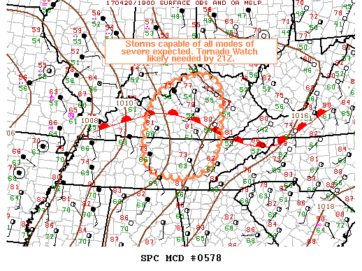
Severe weather watch maybe issued soon for the enclosed area.
-
I wouldn't be surprise if it doesn't go higher. I'm not liking the what the latest HRRR is showing.
-
Not looking good after the two rounds of showers and storms this evening and during the overnight hours. Maybe a break during the daytime hours on Saturday but with the predicted heavy downpours I couldn't imaging the fields being in any condition for baseball.
-
Not looking good after 5 pm EDT. Could also see some storms around 5-6 pm EDT.
-
Just looked at the HRRR simulated radar. Showers and storms could be in the Grant County area around the 5-6 pm EDT time slot.
-
1 pm update from NWS-Louisville: Multiple rounds of showers and storms are expected today and through the weekend. Each round will bring the threat of strong to severe storms and heavy rainfall The greatest threats are heavy rainfall, large hail, damaging winds and isolated tornadoes. The chance for strong to severe storms will last all weekend. The latest HRRR model is showing a significant increase in the chance of tornadoes for late this afternoon into the night. Some of the indices I'm seeing are quite high. Now this doesn't mean that there will be tornadoes but it is a very significant increase since this morning. Timing for now looks like around or after the 5-8 pm EDT time slot. Those in WKY and along the Ohio River up to the NKY area should be on guard around this time. The line of storms should be around the I-75 corridor between 9-11 pm EDT. Then in EKY after midnight. Everyone shouldn't let their guard down after the first round. The HRRR model is showing another round getting started around the 11 pm EDT time slot and track along the same line as the first round. The second round maybe more scattered in nature and look to affect those in northern and western Kentucky. I'm rushed for time but I'll try and update around 5 pm or so. Any emergency weather info until then will more than likely be on our twitter feed. Everyone please be weather aware late today into the overnight hours. You should also be going over your emergency action plan now.
-
As expected the Enhanced Risk Area has been expanded. It now reaches to around the I-75 corridor. Also one thing of note. The chance for strong long track tornadoes has grown. I'll update later when I can.
.thumb.jpg.dc448957daf4ddf2823660190e844abb.jpg)