.png.ffa34568722b20f38e3c3ecfcb9a2cd2.png)

.jpg.dff87640c6ed93f4bdf8eebdf96f5dec.jpg)
nWo
-
Posts
25,617 -
Joined
-
Last visited
-
Days Won
4
5 Followers

Recent Profile Visitors
17,737 profile views


-
.thumb.jpg.dc448957daf4ddf2823660190e844abb.jpg) nWo changed their profile photo
nWo changed their profile photo -
Everyone be safe! We finally made it to Vegas.
-
They were circling around around cynthia eky and the like trying to wait out the storm and started running low on fuel.
-
I'm sitting at bluegrass field. The second round of storms will start around 8 pm edt. Round #1 is over. ➔ Round #2 will begin around 8pm ET (7pm CT). ◆ Individual storms will develop over Western Kentucky and southern Indiana and congeal into a line moving southeast through the region. ➔ Expecting widespread damaging winds, spin-up tornadoes and hail. ➔ Flash flooding, especially over south-central Kentucky. Another 1-3 inches of rainfall, with locally higher amounts possible.
-
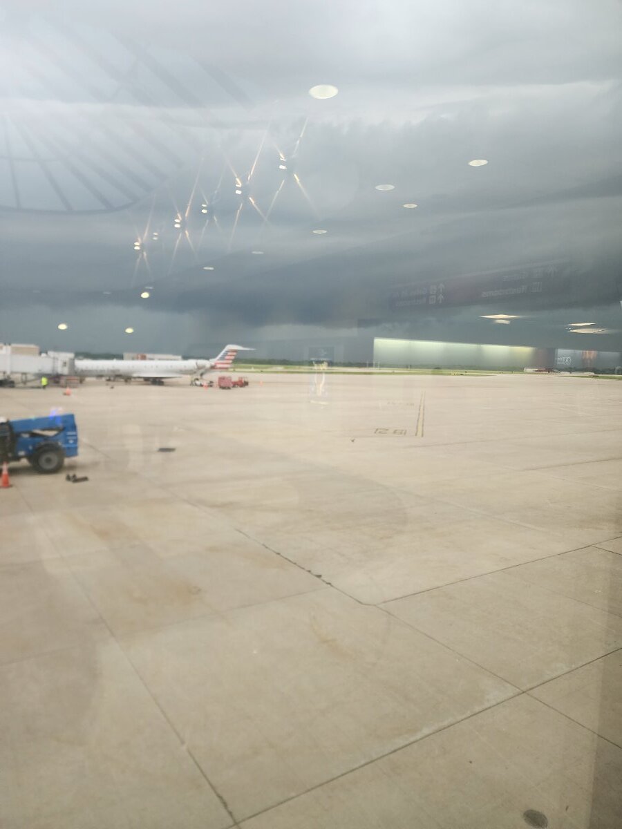
Las Vegas, our plane had to divert to Huntington to refuel. First time we've flown Allegiant the gate attends are great!
-
Our flight has been delayed. May be 1 1/2 hours.
-

-
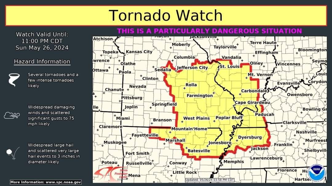
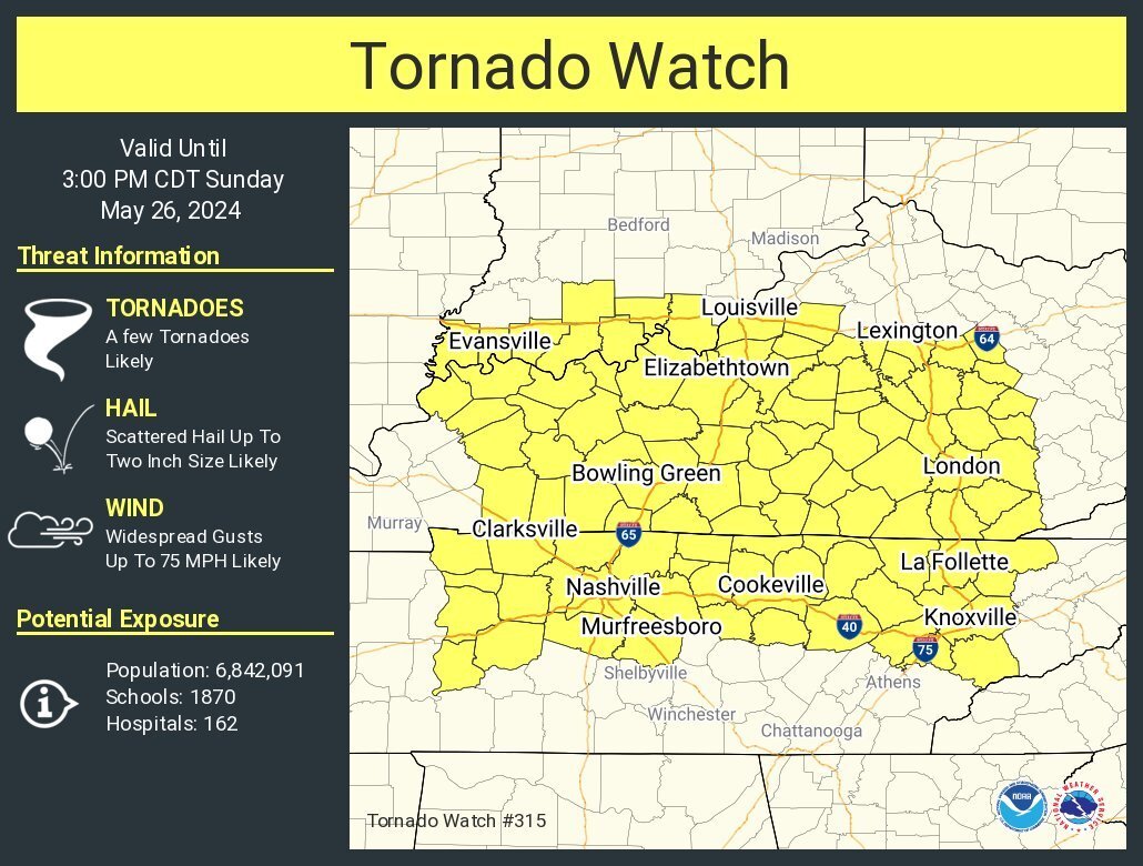
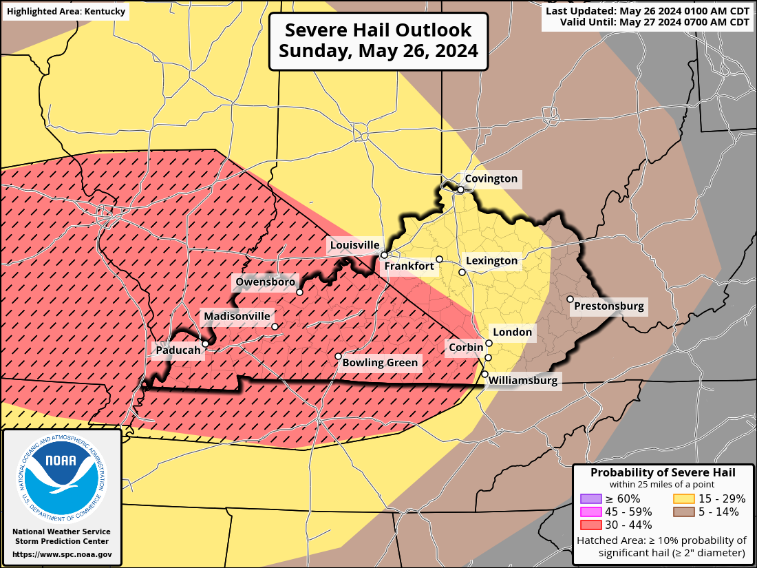
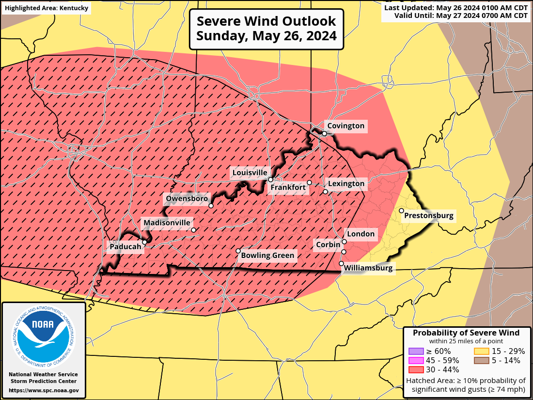
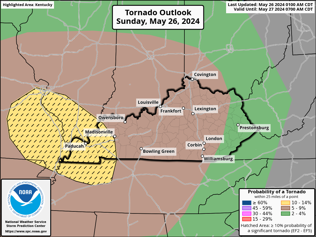
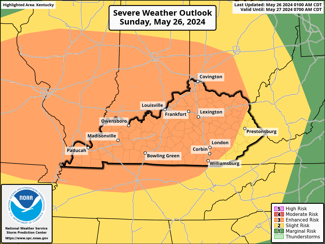
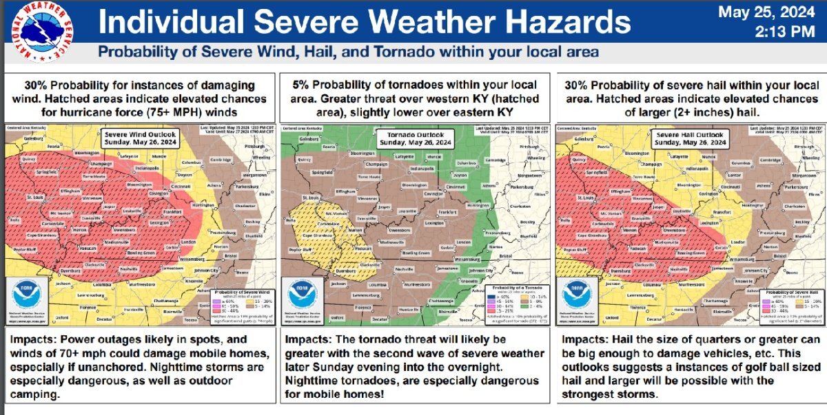
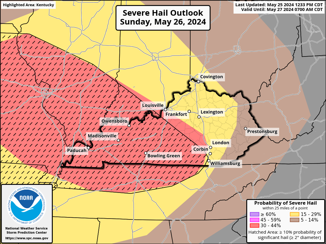
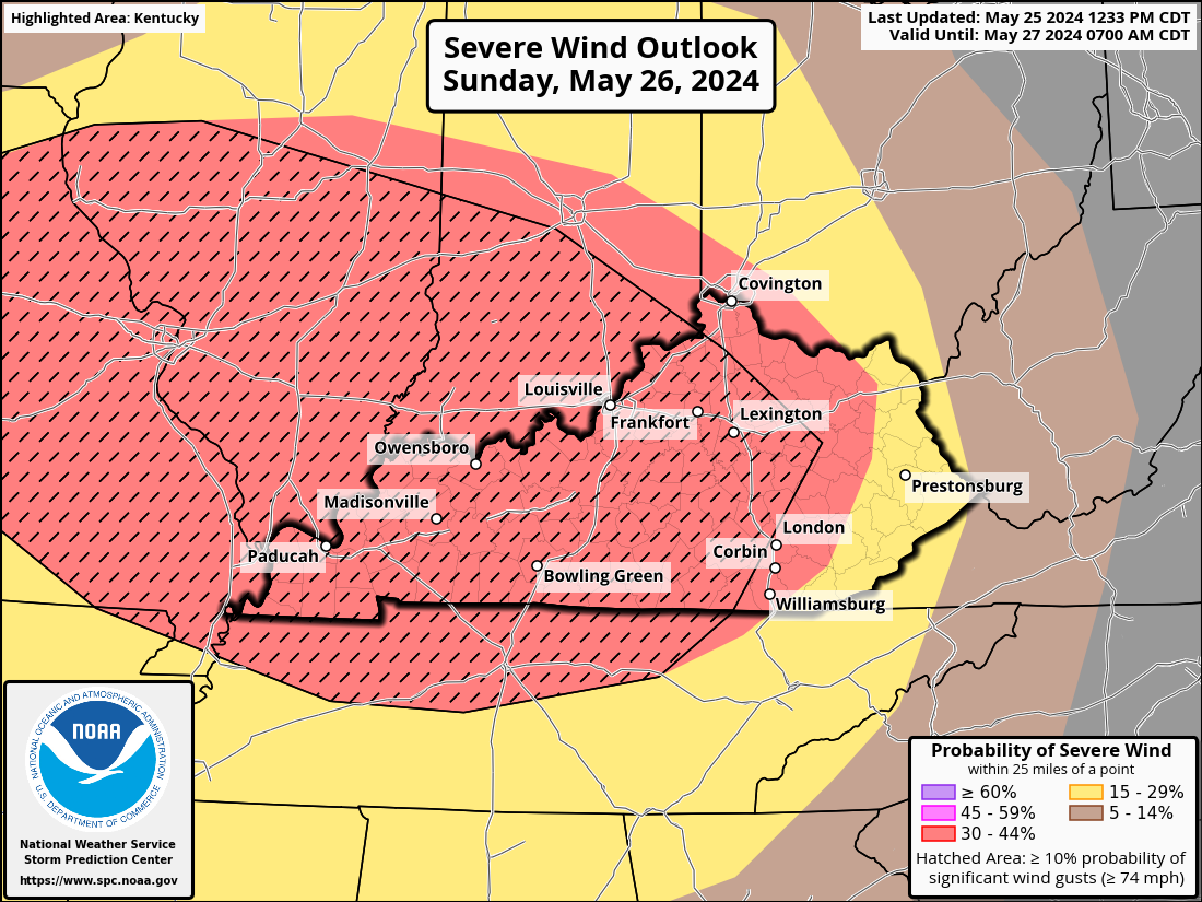
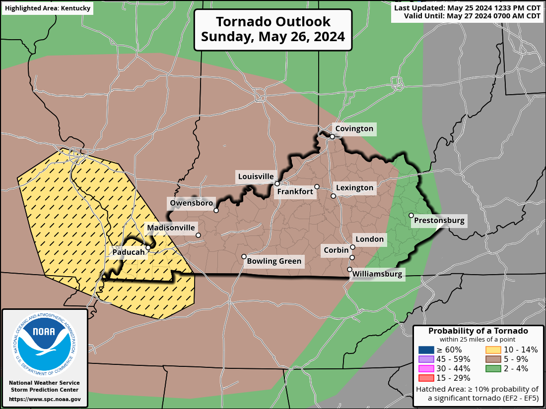
URGENT - IMMEDIATE BROADCAST REQUESTED Tornado Watch Number 315 NWS Storm Prediction Center Norman OK 855 AM CDT Sun May 26 2024 The NWS Storm Prediction Center has issued a * Tornado Watch for portions of Southern Indiana Western and Central Kentucky Western and Middle Tennessee * Effective this Sunday morning and afternoon from 855 AM until 300 PM CDT. * Primary threats include... A few tornadoes likely with a couple intense tornadoes possible Widespread damaging winds and isolated significant gusts to 75 mph likely Scattered large hail and isolated very large hail events to 2 inches in diameter likely SUMMARY...A bowing complex of severe thunderstorms will continue moving rapidly east, with widespread damaging winds likely. Some gusts may exceed 75 mph. A few tornadoes are also possible. The tornado watch area is approximately along and 80 statute miles north and south of a line from 10 miles northwest of Fort Campbell KY to 40 miles south southeast of London KY. For a complete depiction of the watch see the associated watch outline update (WOUS64 KWNS WOU5). PRECAUTIONARY/PREPAREDNESS ACTIONS... REMEMBER...A Tornado Watch means conditions are favorable for tornadoes and severe thunderstorms in and close to the watch area. Persons in these areas should be on the lookout for threatening weather conditions and listen for later statements and possible warnings.
-
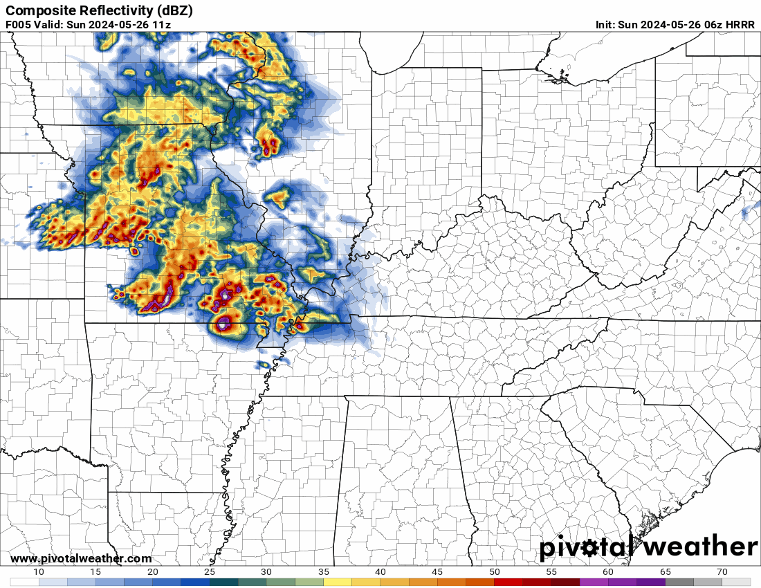
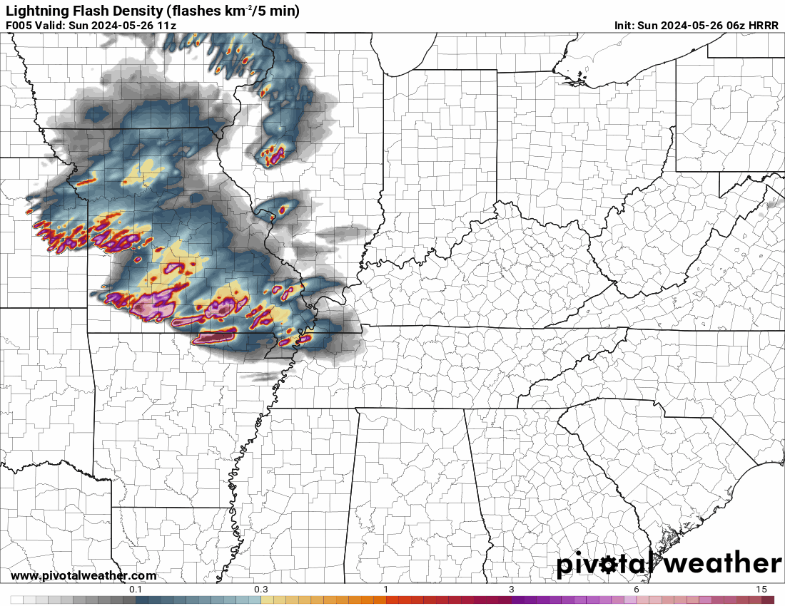
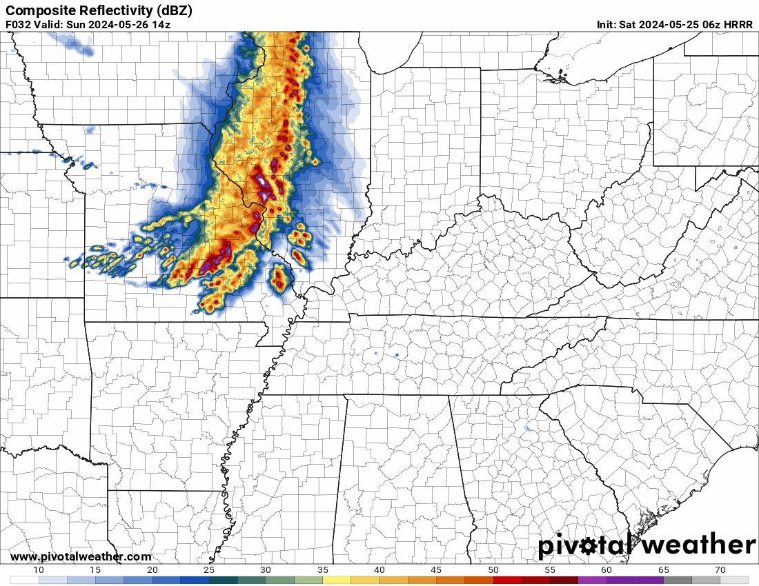
The 06z HRRR serves as a decent example of my earlier post. The time frame is this morning at 7 a.m. EDT until Monday at 5 a.m. EDT. The Lightning Flash Density model suggests that a few of the storms might be strong. It displays the hourly total of lightning strikes from clouds to the ground. Up to six to ten strikes per hour may occur during the strongest storms.
-
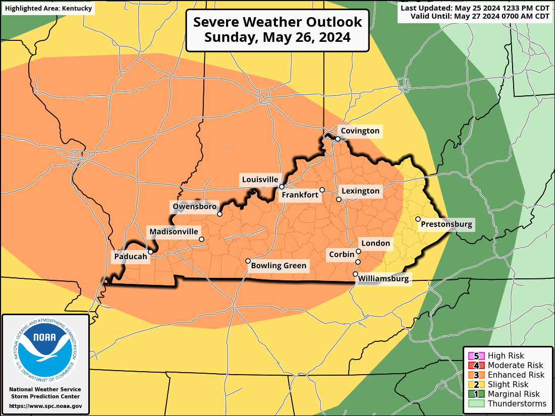
...THERE IS AN ENHANCED RISK OF SEVERE THUNDERSTORMS FOR CENTRAL/EASTERN MISSOURI...CENTRAL/SOUTHERN ILLINOIS/INDIANA...SOUTHWEST OHIO...KENTUCKY...NORTHERN TENNESSEE...EXTREME NORTHEAST ARKANSAS... Widespread strong to severe thunderstorms will be possible across parts of the lower Missouri Valley into the Ohio and Tennessee Valleys later today into tonight. Multiple rounds of storms with the threat of large hail, damaging wind gusts, and a few tornadoes are possible from parts of east-central Missouri into central/southern Illinois and Indiana, much of Kentucky, and adjacent portions of northern Tennessee. A complex but potentially significant severe weather episode is expected later today, with the greatest threat currently expected from parts of the lower Missouri and mid-Mississippi Valleys into the Ohio and Tennessee Valleys. All severe hazards will be possible, including some threat of widespread damaging winds, isolated to scattered very large hail, and potentially a few strong tornadoes. Throughout the day, a seasonably deep mid- to upper-level trough with many embedded shortwaves will travel eastward from the central CONUS into the OH/MS/TN Valleys and portions of the Midwest. Initially centered over eastern Kansas, a surface cyclone will cross Missouri and proceed eastward during the day before shifting northeastward toward the southern Great Lakes region later tonight. A following cold front will eventually enter the Mid-South after traveling southeast across the Ozarks. During the day, a warm front that was first located near the Ohio Valley region may move northward, but its advancement may be impeded by the effects of perhaps extensive convection throughout the area. A significant QLCS( a line of thunderstorms not perfectly straight) may eventually form tonight along/east of the surface-low track and trailing cold front, and a greater area of the OH/TN Valleys and Mid South may continue to be at risk from destructive wind, hail, and maybe a few tornadoes.
-
Highlights from the 3 pm EDT conference call today. Severe weather is possible Sunday into Sunday night, with multiple waves possible during that time. The main hazard is damaging winds, with localized hurricane-force gusts possible. Tornadoes and large hail cannot be ruled out. A flash flood threat may also materialize with repeated rounds of storms. All interests in the Lower Ohio Valley should stay weather-aware over the holiday weekend Timing Wave #1 (11AM - 6 PM EDT) ● Should be in a weakened or weakening state ● Arrive west of I-65 late morning through midday, Spreading east of I-65 through afternoon and early evening. ● These storms may be sub-severe when they arrive. A few warnings (mainly for wind or flooding) are possible Timing Wave #2 (10 PM - 4 AM EDT) ● Conditional Threat. The strength of these storms will depend on the first wave, and whether we can destabilize ● Although it is a conditional threat, it will likely be the most significant if it materializes ● Widespread strong winds 40 to 50 mph, with pockets of damaging wind. Isolated instances of 75+ MPH winds are possible.
-
@TheDeuce Hey, I'll be on in the morning but I don't know when/if I'll be able to post anything tomorrow evening. My plane is not scheduled to land in Las Vegas till around 6:30 PDT. If you could, could you post anything new that comes up for Sunday?
-
Email I received from NWS-Louisville with updated information: Good morning - Organized severe storms are still expected on Sunday. Late afternoon through after midnight is the most favorable time for severe weather, but any part of the day is fair game. Damaging winds are the main threat, with localized hurricane-force gusts possible. Tornadoes, flooding, and large hail have a lower probability but are still on the table. Anorther conference call is planned this afternoon at 3 PM EDT. In the meantime, you can access the briefing slides (will be updated before the conference call) here: https://www.weather.gov/media/lmk/DssPacket.pdf Thanks, NWS Louisville, KY
-
This is the 06z HRRR. If you listen to the conference call you heard, it mention individual supercells developing if the cap is broken. This shows possible cells forming ahead of the line around 2-4 pm EDT.