

nWo
BGP Meteorologist
-
Joined
-
Last visited
Everything posted by nWo
-
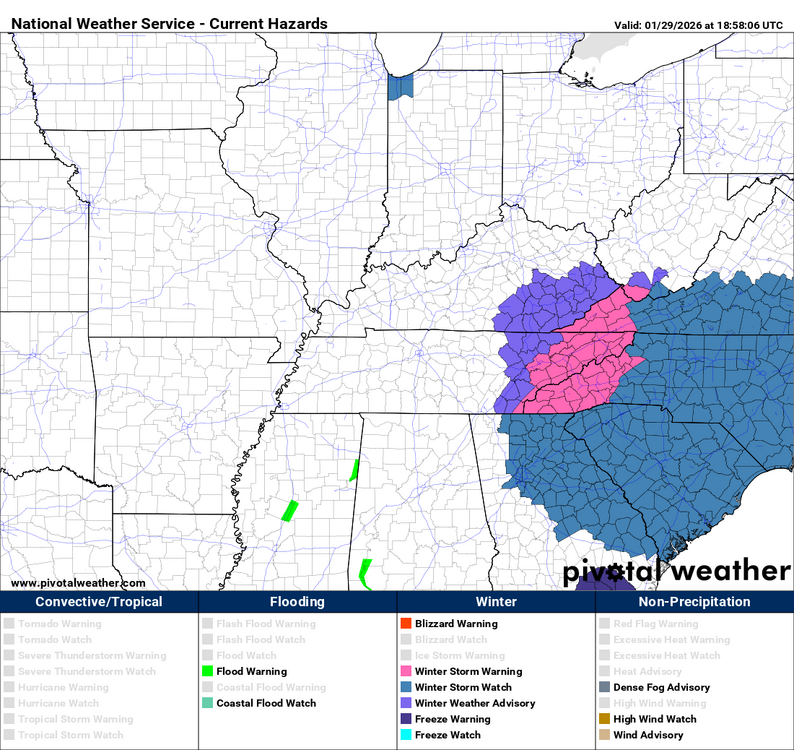
URGENT - WINTER WEATHER MESSAGE National Weather Service Jackson KY 150 PM EST Thu Jan 29 2026 KYZ058-107-111-300300- /O.NEW.KJKL.WW.Y.0004.260130T1100Z-260131T0000Z/ Estill-Johnson-Lee- Including the cities of Irvine, Paintsville, Beattyville, and Ravenna 150 PM EST Thu Jan 29 2026 ...WINTER WEATHER ADVISORY IN EFFECT FROM 6 AM TO 7 PM EST FRIDAY... * WHAT...Snow expected. Total snow accumulations up to one inch, greatest amounts over the southern portion of each county. * WHERE...Estill, Johnson, and Lee Counties. * WHEN...From 6 AM to 7 PM EST Friday. * IMPACTS...Plan on slippery road conditions. The hazardous conditions could impact the Friday morning and evening commutes. PRECAUTIONARY/PREPAREDNESS ACTIONS... Slow down and use caution while traveling. The latest road conditions for Kentucky can be found by visiting https://goky.ky.gov.
-
URGENT - WINTER WEATHER MESSAGE National Weather Service Jackson KY 150 PM EST Thu Jan 29 2026 KYZ085>088-110-113-115>118-120-300300- /O.NEW.KJKL.WW.Y.0004.260130T1100Z-260131T1700Z/ Whitley-Knox-Bell-Harlan-Floyd-Knott-Perry-Clay-Leslie-Letcher- Pike- Including the cities of South Williamson, Hazard, Williamsburg, Middlesboro, Cumberland, Hyden, Barbourville, Elkhorn City, Pineville, Whitesburg, Jenkins, Pikeville, Wheelwright, Pippa Passes, Manchester, Harlan, Hindman, Prestonsburg, Corbin, and Coal Run 150 PM EST Thu Jan 29 2026 ...WINTER WEATHER ADVISORY IN EFFECT FROM 6 AM FRIDAY TO NOON EST SATURDAY... * WHAT...Snow expected. Total snow accumulations of 1 to 3 inches with locally higher amounts possible, especially at elevations above 1,500 feet. * WHERE...Portions of south central and southeast Kentucky. * WHEN...From 6 AM Friday to noon EST Saturday. * IMPACTS...Plan on slippery road conditions. The hazardous conditions could impact the Friday morning and evening commutes. PRECAUTIONARY/PREPAREDNESS ACTIONS... Slow down and use caution while traveling. The latest road conditions for Kentucky can be found by visiting https://goky.ky.gov.
-
This could be the result of the system if it forms. This is not to be considered a forecast.
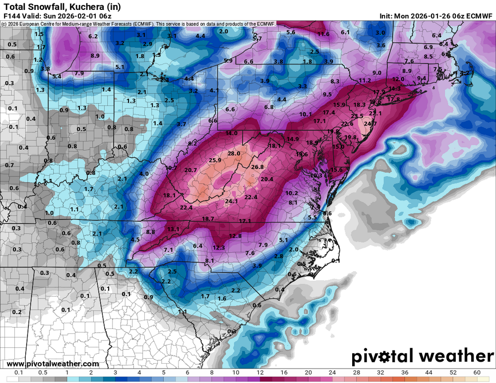 Timing is hard this far out, but I'm watching to see if a low-pressure system will form round the Oklahoma/Texas area and move towards the gulf. It is forecast to move up the east coast. If it hugs the coast, it could become a bomb cyclone and cause possible blizzard conditions in New England. If the track moves northward, it will affect Kentucky more. It still could throw some snow our way. The timing is going back and forth. It was showing Wednesday, Then Thursday. Now it is Friday but we know things will change.From what I've learned. It is around 850 mb level, which is around 5,000 feet.URGENT - WEATHER MESSAGE National Weather Service Jackson KY 224 AM EST Mon Jan 26 2026 KYZ044-050>052-058-059-068-069-079-083-261930- /O.UPG.KJKL.EC.A.0001.260126T2300Z-260127T1700Z/ /O.NEW.KJKL.EC.W.0001.260127T0000Z-260127T1700Z/ /O.CON.KJKL.CW.Y.0003.000000T0000Z-260126T1700Z/ Fleming-Montgomery-Bath-Rowan-Estill-Powell-Rockcastle-Jackson- Pulaski-Wayne- Including the cities of Stanton, Mount Vernon, Somerset, Ravenna, Irvine, Jeffersonville, Brodhead, Morehead, Owingsville, Flemingsburg, Camargo, McKee, Clay City, Burnside, Monticello, Annville, and Mount Sterling 224 AM EST Mon Jan 26 2026 ...COLD WEATHER ADVISORY REMAINS IN EFFECT UNTIL NOON EST TODAY... ...EXTREME COLD WARNING IN EFFECT FROM 7 PM THIS EVENING TO NOON EST TUESDAY... * WHAT...For the Cold Weather Advisory, very cold wind chills as low as 5 below. For the Extreme Cold Warning, dangerously cold wind chills as low as 17 below expected. * WHERE...Bath, Estill, Fleming, Montgomery, Powell, Rowan, Pulaski, Rockcastle, Wayne, and Jackson Counties. * WHEN...For the Cold Weather Advisory, until noon EST today. For the Extreme Cold Warning, from 7 PM this evening to noon EST Tuesday. * IMPACTS...The cold wind chills could result in hypothermia or frostbite if precautions are not taken. PRECAUTIONARY/PREPAREDNESS ACTIONS... Dress in layers including a hat, face mask, and gloves if you must go outside. To prevent water pipes from freezing; wrap or drain or allow them to drip slowly. Use caution while traveling outside. Wear appropriate clothing, a hat, and gloves.URGENT - WEATHER MESSAGE National Weather Service Jackson KY 224 AM EST Mon Jan 26 2026 KYZ060-080-084>088-106-108-111-114-116-118-261930- /O.UPG.KJKL.EC.A.0001.260126T2300Z-260127T1700Z/ /O.NEW.KJKL.EC.W.0001.260127T0000Z-260127T1700Z/ /O.CON.KJKL.CW.Y.0003.000000T0000Z-260126T1700Z/ Menifee-Laurel-McCreary-Whitley-Knox-Bell-Harlan-Morgan-Wolfe-Lee- Owsley-Clay-Letcher- Including the cities of Harlan, Manchester, Stearns, Frenchburg, Cumberland, Williamsburg, Corbin, West Liberty, Beattyville, Jenkins, Middlesboro, Barbourville, Whitesburg, Campton, Booneville, Whitley City, Pineville, and London 224 AM EST Mon Jan 26 2026 ...COLD WEATHER ADVISORY REMAINS IN EFFECT UNTIL NOON EST TODAY... ...EXTREME COLD WARNING IN EFFECT FROM 7 PM THIS EVENING TO NOON EST TUESDAY... * WHAT...For the Cold Weather Advisory, very cold wind chills as low as 5 below. For the Extreme Cold Warning, dangerously cold wind chills as low as 15 below or colder expected. * WHERE...Portions of east central, south central, and southeast Kentucky. * WHEN...For the Cold Weather Advisory, until noon EST today. For the Extreme Cold Warning, from 7 PM this evening to noon EST Tuesday. * IMPACTS...The cold wind chills could result in hypothermia or frostbite if precautions are not taken. PRECAUTIONARY/PREPAREDNESS ACTIONS... Dress in layers including a hat, face mask, and gloves if you must go outside. To prevent water pipes from freezing; wrap or drain or allow them to drip slowly. Use caution while traveling outside. Wear appropriate clothing, a hat, and gloves.URGENT - WEATHER MESSAGE National Weather Service Wilmington OH 133 AM EST Mon Jan 26 2026 INZ050-058-059-066-073>075-080-KYZ089>100-OHZ026-034-035-042>046- 051>056-060>065-070>074-077>082-088-262100- /O.CON.KILN.EC.W.0001.260126T2300Z-260127T1700Z/ /O.CON.KILN.CW.Y.0004.000000T0000Z-260126T2300Z/ Wayne-Fayette-Union-Franklin-Ripley-Dearborn-Ohio-Switzerland- Carroll-Gallatin-Boone-Kenton-Campbell-Owen-Grant-Pendleton- Bracken-Robertson-Mason-Lewis-Hardin-Mercer-Auglaize-Darke-Shelby- Logan-Union-Delaware-Miami-Champaign-Clark-Madison-Franklin- Licking-Preble-Montgomery-Greene-Fayette-Pickaway-Fairfield- Butler-Warren-Clinton-Ross-Hocking-Hamilton-Clermont-Brown- Highland-Adams-Pike-Scioto- Including the cities of Connersville, Marysville, Dillsboro, Williamstown, Mount Orab, Dayton, Fort Thomas, Augusta, West Jefferson, Ripley, Bright, Carrollton, Camden, Oakbrook, Maysville, Landen, Tipp City, Chillicothe, Middletown, Urbana, London, Owenton, Dry Ridge, Manchester, Rising Sun, Aberdeen, Florence, Butler, Circleville, Greenville, Plain City, Waverly, Highland Heights, Aurora, Winchester, Logan, Liberty, Withamsville, Mount Olivet, Washington Court House, Delaware, Piqua, Burlington, Vanceburg, Hamilton, Summerside, Lawrenceburg, Pike Lake, West Union, Versailles, Hidden Valley, Milan, Bellefontaine, Wapakoneta, Head Of Grassy, Lebanon, Kenton, Sidney, Springboro, Richmond, Georgetown, Newark, Peebles, Brookville, Independence, Batesville, Hillsboro, Newport, Day Heights, Mount Repose, Camp Dix, West College Corner, Troy, Vevay, Mount Carmel, Alexandria, Portsmouth, Beavercreek, Piketon, Kettering, Celina, Seaman, Ada, St. Marys, Erlanger, Tollesboro, Wilmington, Covington, Lancaster, Warsaw, Mason, Bellevue, Coldwater, Blanchester, Milford, Xenia, Fairborn, Brooksville, Osgood, Springfield, New Bremen, Falmouth, Pickerington, Downtown Cincinnati, Crittenden, Downtown Columbus, Oxford, Greenfield, Greendale, Fairfield, Mulberry, Minster, Eaton, Franklin, Downtown Dayton, and Wheelersburg 133 AM EST Mon Jan 26 2026 ...COLD WEATHER ADVISORY REMAINS IN EFFECT UNTIL 6 PM EST THIS EVENING... ...EXTREME COLD WARNING REMAINS IN EFFECT FROM 6 PM THIS EVENING TO NOON EST TUESDAY... * WHAT...For the Cold Weather Advisory, very cold wind chills as low as 15 below zero expected. For the Extreme Cold Warning, dangerously cold wind chills as low as 25 below zero expected. * WHERE...Portions of east central and southeast Indiana, northeast and northern Kentucky, and central, south central, southwest, and west central Ohio. * WHEN...For the Cold Weather Advisory, until 6 PM EST this evening. For the Extreme Cold Warning, from 6 PM this evening to noon EST Tuesday. * IMPACTS...The dangerously cold wind chills could cause frostbite on exposed skin in as little as 30 minutes. PRECAUTIONARY/PREPAREDNESS ACTIONS... Dress in layers including a hat, face mask, and gloves if you must go outside. Keep pets indoors as much as possible. Make sure outdoor animals have a warm, dry shelter, food, and unfrozen water.URGENT - WEATHER MESSAGE National Weather Service Louisville KY 457 AM EST Mon Jan 26 2026 INZ076>079-083-084-089>092-KYZ023>043-045>049-053>057-061>067- 070>078-081-082-262200- /O.CON.KLMK.EC.W.0001.260127T0000Z-260127T1600Z/ /O.CON.KLMK.CW.Y.0003.000000T0000Z-260127T0000Z/ Orange-Washington IN-Scott IN-Jefferson IN-Dubois-Crawford-Perry- Harrison IN-Floyd-Clark IN-Hancock-Breckinridge-Meade-Ohio- Grayson-Hardin-Bullitt-Jefferson-Oldham-Trimble-Henry-Shelby- Franklin-Scott KY-Harrison KY-Spencer-Anderson-Woodford-Fayette- Bourbon-Nicholas-Nelson-Washington KY-Mercer-Jessamine-Clark KY- Larue-Marion-Boyle-Garrard-Madison-Butler-Edmonson-Hart-Green- Taylor-Casey-Lincoln-Logan-Warren-Simpson-Allen-Barren-Monroe- Metcalfe-Adair-Russell-Cumberland-Clinton- Including the cities of New Albany, Jasper, Hardinsburg, Taylorsville, Georgetown, Richmond, Lebanon, Salem, Nicholasville, Tompkinsville, Scottsburg, Bowling Green, Stanford, Cynthiana, Campbellsville, Hartford, Winchester, Scottsville, Lawrenceburg, Jamestown, Horse Cave, Russellville, Glasgow, Tell City, English, La Grange, Lancaster, Lexington, Greensburg, Columbia, Carlisle, Elizabethtown, Milton, Lewisport, Leitchfield, Frankfort, Bedford, Edmonton, Paoli, Franklin, Shepherdsville, Burkesville, Corydon, Springfield, Harrodsburg, Louisville, Shelbyville, Paris, Providence, Versailles, Hodgenville, Liberty, Madison, Jeffersonville, Brandenburg, Danville, Morgantown, Hawesville, Brownsville, Albany, New Castle, and Bardstown 457 AM EST Mon Jan 26 2026 /357 AM CST Mon Jan 26 2026/ ...COLD WEATHER ADVISORY REMAINS IN EFFECT UNTIL 7 PM EST /6 PM CST/ THIS EVENING... ...EXTREME COLD WARNING REMAINS IN EFFECT FROM 7 PM EST /6 PM CST/ THIS EVENING TO 11 AM EST /10 AM CST/ TUESDAY... * WHAT...For the Cold Weather Advisory, very cold wind chills as low as 13 below. For the Extreme Cold Warning, dangerously cold wind chills as low as 18 below expected. * WHERE...Portions of south central Indiana and central Kentucky. * WHEN...For the Cold Weather Advisory, until 7 PM EST /6 PM CST/ this evening. For the Extreme Cold Warning, from 7 PM EST /6 PM CST/ this evening to 11 AM EST /10 AM CST/ Tuesday. * IMPACTS...The dangerously cold wind chills as low as 20 below zero could result in hypothermia or frostbite if precautions are not taken. PRECAUTIONARY/PREPAREDNESS ACTIONS... Dress in layers including a hat, face mask, and gloves if you must go outside. Use caution while traveling outside. Wear appropriate clothing, a hat, and gloves. Make frequent checks on older family, friends, and neighbors. Ensure portable heaters are used correctly. Do not use generators or grills inside.I learned a new term. This was caused by a "Warm Toe". A narrow band of warm air aloft that extends into cold air above the surface. It changes snow into sleet and then freezing rain.URGENT - WEATHER MESSAGE National Weather Service Jackson KY 125 PM EST Sun Jan 25 2026 KYZ060-080-084>088-106-108-109-111>118-261100- /O.EXA.KJKL.CW.Y.0003.260126T0500Z-260126T1700Z/ /O.CON.KJKL.EC.A.0001.260126T2300Z-260127T1700Z/ Menifee-Laurel-McCreary-Whitley-Knox-Bell-Harlan-Morgan-Wolfe- Magoffin-Lee-Breathitt-Knott-Owsley-Perry-Clay-Leslie-Letcher- Including the cities of Pineville, Whitesburg, Hazard, Hyden, Barbourville, Cumberland, Harlan, Salyersville, Corbin, London, Frenchburg, Jenkins, Whitley City, Stearns, Manchester, Beattyville, Hindman, Middlesboro, Jackson, Williamsburg, Campton, Pippa Passes, Booneville, and West Liberty 125 PM EST Sun Jan 25 2026 ...COLD WEATHER ADVISORY IN EFFECT FROM MIDNIGHT TONIGHT TO NOON EST MONDAY... ...EXTREME COLD WATCH REMAINS IN EFFECT FROM MONDAY EVENING THROUGH TUESDAY MORNING... * WHAT...For the Cold Weather Advisory, very cold wind chills as low as 5 below expected. For the Extreme Cold Watch, dangerously cold wind chills as low as 20 below possible. * WHERE...Portions of east central, south central, and southeast Kentucky. * WHEN...For the Cold Weather Advisory, from midnight tonight to noon EST Monday. For the Extreme Cold Watch, from Monday evening through Tuesday morning. * IMPACTS...The cold wind chills as low as 20 below zero could result in hypothermia if precautions are not taken. PRECAUTIONARY/PREPAREDNESS ACTIONS... Dress in layers including a hat, face mask, and gloves if you must go outside. Use caution while traveling outside. Wear appropriate clothing, a hat, and gloves.URGENT - WEATHER MESSAGE National Weather Service Paducah KY 1213 AM CST Mon Jan 26 2026 ILZ075>078-080>094-INZ081-082-085>088-KYZ001>022-MOZ076-086-087-100- 107>112-114-262200- /O.EXP.KPAH.CW.Y.0001.000000T0000Z-260126T0600Z/ /O.CON.KPAH.EC.W.0001.000000T0000Z-260127T1600Z/ Jefferson-Wayne IL-Edwards-Wabash-Perry IL-Franklin-Hamilton- White-Jackson-Williamson-Saline-Gallatin-Union-Johnson-Pope- Hardin-Alexander-Pulaski-Massac-Gibson-Pike-Posey-Vanderburgh- Warrick-Spencer-Fulton-Hickman-Carlisle-Ballard-McCracken-Graves- Livingston-Marshall-Calloway-Crittenden-Lyon-Trigg-Caldwell-Union KY-Webster-Hopkins-Christian-Henderson-Daviess-McLean-Muhlenberg- Todd-Perry MO-Bollinger-Cape Girardeau-Wayne MO-Carter-Ripley- Butler-Stoddard-Scott-Mississippi-New Madrid- Including the cities of Madisonville, Calhoun, Petersburg, Vienna, Elkton, Wickliffe, Poseyville, Piedmont, Cairo, Murray, Bloomfield, Fort Branch, Mound City, Marble Hill, Poplar Bluff, Charleston, Mayfield, Bardwell, Albion, Evansville, Princeton, Smithland, Dixon, Hopkinsville, Mount Carmel, Clinton, Carbondale, New Madrid, Owensboro, Mount Vernon, Sikeston, Golconda, Murphysboro, Greenville, Carmi, West Frankfort, Boonville, Rockport, Cape Girardeau, Jonesboro, Fairfield, Pinckneyville, Marion, Jackson, Hickman, Doniphan, Metropolis, Van Buren, Henderson, Perryville, Morganfield, Eddyville, Cadiz, Benton, McLeansboro, Paducah, Shawneetown, Elizabethtown, Herrin, and Harrisburg 1213 AM CST Mon Jan 26 2026 /113 AM EST Mon Jan 26 2026/ ...EXTREME COLD WARNING REMAINS IN EFFECT UNTIL 10 AM CST /11 AM EST/ TUESDAY... * WHAT...Dangerously cold wind chills as low as 10 to 19 below zero are expected. * WHERE...all of of southern Illinois, southwest Indiana, western Kentucky, and southeast Missouri. * WHEN...Until 10 AM CST /11 AM EST/ Tuesday. * IMPACTS...The cold wind chills as low as 19 below zero could result in hypothermia if precautions are not taken. Frostbite and hypothermia will occur if unprotected skin is exposed to these temperatures. PRECAUTIONARY/PREPAREDNESS ACTIONS... Dress in layers including a hat, face mask, and gloves if you must go outside. Make frequent checks on older family, friends, and neighbors. Ensure portable heaters are used correctly. Do not use generators or grills inside.Yes, I just came back in. The temperature has dropped below freezing, and what is left is already refrozen.This is what we have at my house. My son and I were clearing the driveway and walkway. The battery ran down on my Snow Joe. First time that has happened. The snow and freezing rain accumulation is so thick. It is a little over the capacity of the shovel of 6 inches. I wouldn't be shoveling this snow if I didn't have one.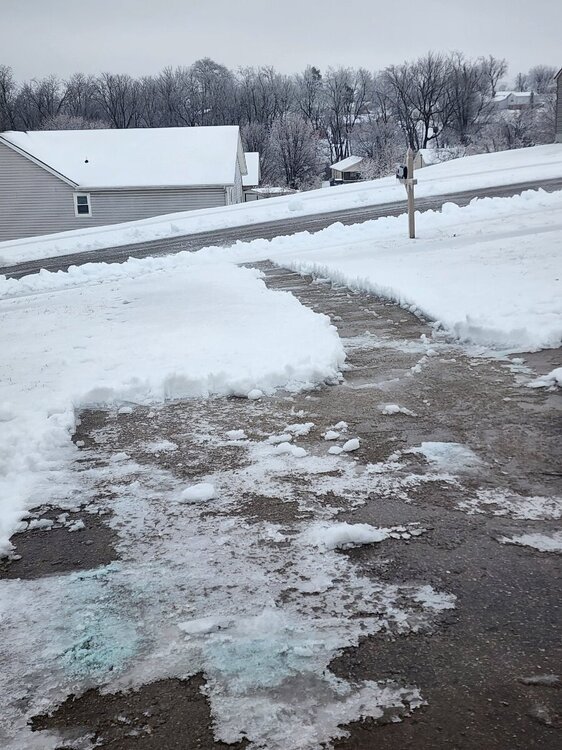
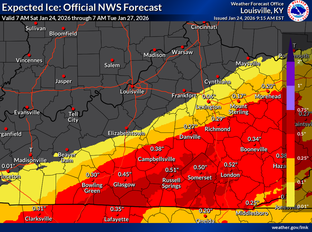
 Power outages: https://poweroutage.us/area/state/kentuckyMajor Ice Accumulations Expected Major ice accumulations are expected south of the Kentucky Parkways, with 0.50-0.75+ inches of ice. Prolonged significant impacts are expected, including very dangerous road conditions, tree damage, downed power lines, and multi-day power outages. Avoid travel unless absolutely necessary.
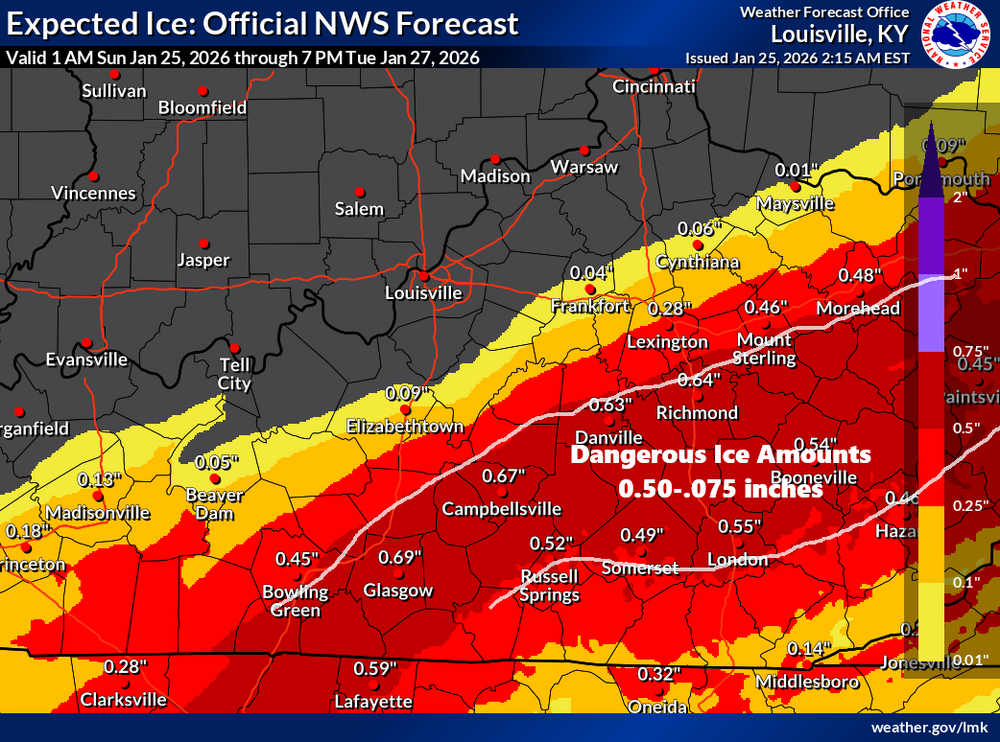 URGENT - WINTER WEATHER MESSAGE National Weather Service Paducah KY 1139 PM CST Sat Jan 24 2026 KYZ009-012-017-021-022-252100- /O.UPG.KPAH.WS.W.0001.000000T0000Z-260126T0000Z/ /O.NEW.KPAH.IS.W.0001.260125T0539Z-260126T0000Z/ Calloway-Trigg-Christian-Muhlenberg-Todd- Including the cities of Hopkinsville, Cadiz, Murray, Greenville, and Elkton 1139 PM CST Sat Jan 24 2026 ...ICE STORM WARNING IN EFFECT UNTIL 6 PM CST SUNDAY... * WHAT...Significant icing. Ice accumulations between a quarter to half of an inch and additional snow and sleet accumulations up to two inches. * WHERE...Calloway, Christian, Muhlenberg, Todd, and Trigg Counties. * WHEN...Until 6 PM CST Sunday. * IMPACTS...Power outages and tree damage are likely due to the ice. Travel could be nearly impossible. Extreme cold will exacerbate the danger. PRECAUTIONARY/PREPAREDNESS ACTIONS... Travel is strongly discouraged. If you must travel, keep an extra flashlight, food and water in your vehicle in case of an emergency. Prepare for possible power outages. The latest road conditions can be obtained by visiting www.weather.gov/pah/roads Persons should delay all travel if possible. If travel is absolutely necessary, drive with extreme caution and be prepared for sudden changes in visibility. Leave plenty of room between you and the motorist ahead of you, and allow extra time to reach your destination. Avoid sudden braking or acceleration, and be especially cautious on hills or when making turns. Make sure your car is winterized and in good working order.URGENT - WEATHER MESSAGE National Weather Service Jackson KY 204 PM EST Sat Jan 24 2026 KYZ060-080-084>088-104-106>120-251100- /O.NEW.KJKL.EC.A.0001.260126T2300Z-260127T1700Z/ Menifee-Laurel-McCreary-Whitley-Knox-Bell-Harlan-Elliott-Morgan- Johnson-Wolfe-Magoffin-Floyd-Lee-Breathitt-Knott-Owsley-Perry- Clay-Leslie-Letcher-Martin-Pike- Including the cities of Pineville, Whitesburg, Hazard, Inez, Hyden, Barbourville, Cumberland, Harlan, Salyersville, Corbin, London, South Williamson, Wheelwright, Frenchburg, Jenkins, Sandy Hook, Whitley City, Stearns, Manchester, Paintsville, Beattyville, Prestonsburg, Elkhorn City, Coal Run, Hindman, Middlesboro, Jackson, Williamsburg, Campton, Pippa Passes, Booneville, Pikeville, and West Liberty 204 PM EST Sat Jan 24 2026 ...EXTREME COLD WATCH IN EFFECT FROM MONDAY EVENING THROUGH TUESDAY MORNING... * WHAT...Dangerously cold wind chills as low as 15 below possible. * WHERE...Portions of east central, northeast, south central, and southeast Kentucky. * WHEN...From Monday evening through Tuesday morning. * IMPACTS...The cold wind chills as low as 15 below zero could result in hypothermia if precautions are not taken. PRECAUTIONARY/PREPAREDNESS ACTIONS... Dress in layers including a hat, face mask, and gloves if you must go outside.URGENT - WEATHER MESSAGE National Weather Service Wilmington OH 132 PM EST Sat Jan 24 2026 INZ050-058-059-066-073>075-080-KYZ089>100-OHZ026-034-035-042>046- 051>056-060>065-070>074-077>082-088-250245- /O.NEW.KILN.CW.Y.0004.260126T0500Z-260126T2300Z/ /O.NEW.KILN.EC.A.0001.260126T2300Z-260127T1700Z/ Wayne-Fayette-Union-Franklin-Ripley-Dearborn-Ohio-Switzerland- Carroll-Gallatin-Boone-Kenton-Campbell-Owen-Grant-Pendleton- Bracken-Robertson-Mason-Lewis-Hardin-Mercer-Auglaize-Darke-Shelby- Logan-Union-Delaware-Miami-Champaign-Clark-Madison-Franklin- Licking-Preble-Montgomery-Greene-Fayette-Pickaway-Fairfield- Butler-Warren-Clinton-Ross-Hocking-Hamilton-Clermont-Brown- Highland-Adams-Pike-Scioto- Including the cities of Chillicothe, Mount Repose, Kettering, Greendale, Brookville, Vevay, Dayton, Greenville, Summerside, Lancaster, Winchester, Delaware, London, Mount Orab, Seaman, Coldwater, Troy, Hidden Valley, Xenia, Richmond, Falmouth, Kenton, West College Corner, Warsaw, Florence, Vanceburg, Augusta, Middletown, Georgetown, Circleville, Minster, Beavercreek, Crittenden, Landen, West Union, Lawrenceburg, Hamilton, Springboro, Downtown Cincinnati, Mount Olivet, Newport, Batesville, Sidney, Tipp City, Camden, St. Marys, Peebles, Highland Heights, Hillsboro, Bellefontaine, Withamsville, Wapakoneta, Connersville, Aurora, Marysville, Waverly, Milan, Rising Sun, Portsmouth, Springfield, Bellevue, Head Of Grassy, Downtown Dayton, Versailles, Camp Dix, Mulberry, Brooksville, Newark, Alexandria, Ripley, Plain City, Celina, Maysville, Covington, Pike Lake, Burlington, Osgood, Blanchester, Mason, Piqua, Franklin, Oakbrook, Fort Thomas, Dillsboro, Dry Ridge, Eaton, Lebanon, West Jefferson, Bright, Downtown Columbus, Fairfield, Aberdeen, Greenfield, Day Heights, New Bremen, Erlanger, Fairborn, Oxford, Urbana, Manchester, Tollesboro, Milford, Williamstown, Wheelersburg, Wilmington, Mount Carmel, Independence, Carrollton, Ada, Washington Court House, Logan, Pickerington, Piketon, Butler, Owenton, and Liberty 132 PM EST Sat Jan 24 2026 ...COLD WEATHER ADVISORY IN EFFECT FROM MIDNIGHT SUNDAY NIGHT TO 6 PM EST MONDAY... ...EXTREME COLD WATCH IN EFFECT FROM MONDAY EVENING THROUGH TUESDAY MORNING... * WHAT...For the Cold Weather Advisory, very cold wind chills as low as around 15 below zero expected. For the Extreme Cold Watch, dangerously cold wind chills as low as around 25 below zero possible. * WHERE...Portions of east central and southeast Indiana, northeast and northern Kentucky, and central, south central, southwest, and west central Ohio. * WHEN...For the Cold Weather Advisory, from midnight Sunday Night to 6 PM EST Monday. For the Extreme Cold Watch, from Monday evening through Tuesday morning. * IMPACTS...The dangerously cold wind chills could cause frostbite on exposed skin in as little as 30 minutes. PRECAUTIONARY/PREPAREDNESS ACTIONS... Dress in layers including a hat, face mask, and gloves if you must go outside. Keep pets indoors as much as possible. Make sure outdoor animals have a warm, dry shelter, food, and unfrozen water.The storm track seems to have moved further north. As of this morning some of the snow totals are lower. But on the other hand, that means the ice line has jogged north. Those near the Cumberland Pkwy southward could see around .50 inch of ice accumulation.
.thumb.png.52f4ab0cb8754f05d401027ab3492c54.png)
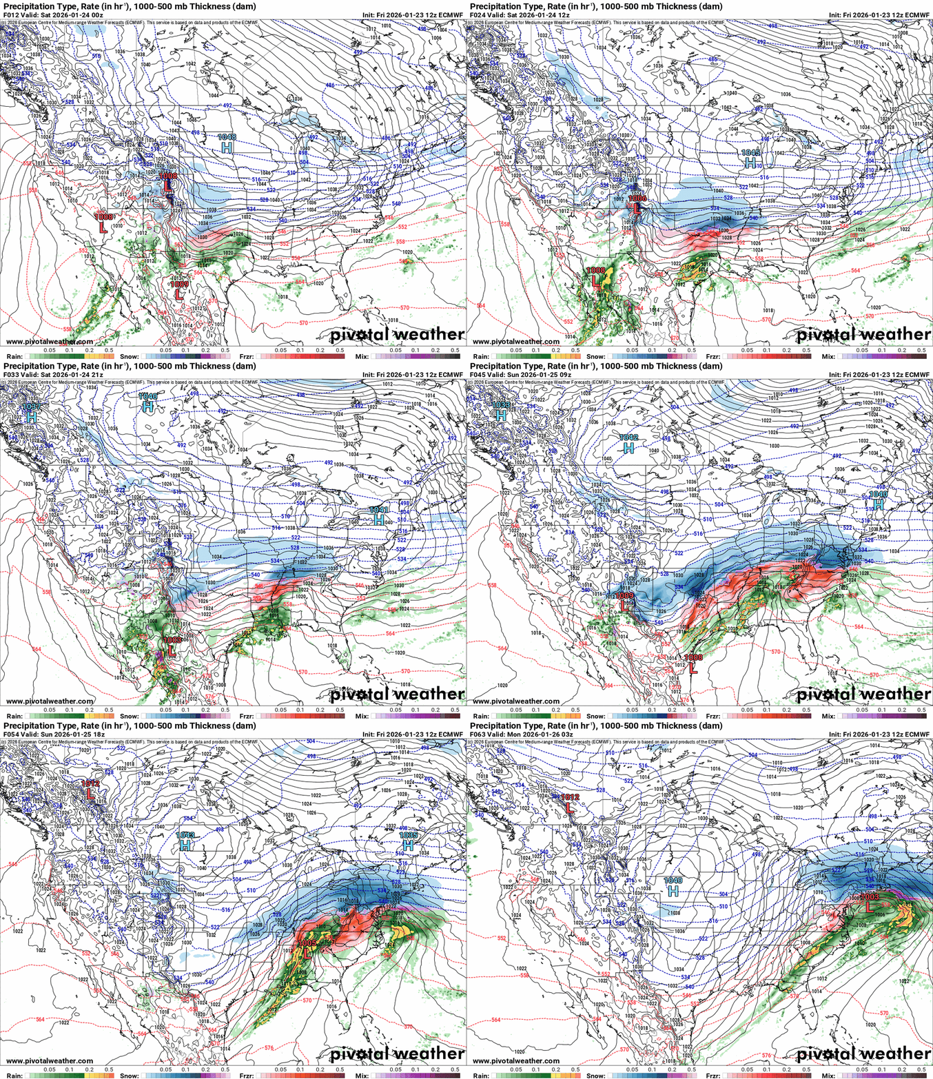
 If everyone remembers, in one of my earlier forecasts I talked about an upper-level low around California. That if that merges with the low-pressure system that forms and moves southeast towards Kentucky, this storm will gather strength and produce more snow than earlier predicted. The Euro is showing that scenario. They will merge starting tonight, and the low will strengthen. It now depends on the track. If it takes a more southerly route, the snow totals will increase. If it moves closer to Kentucky, then it will draw more warm Gulf moisture and produce more ice, and the snow totals could be affected in a negative way. The snow will break out tonight southwest of Kentucky. As the system moves toward Kentucky, it will merge and gather some strength.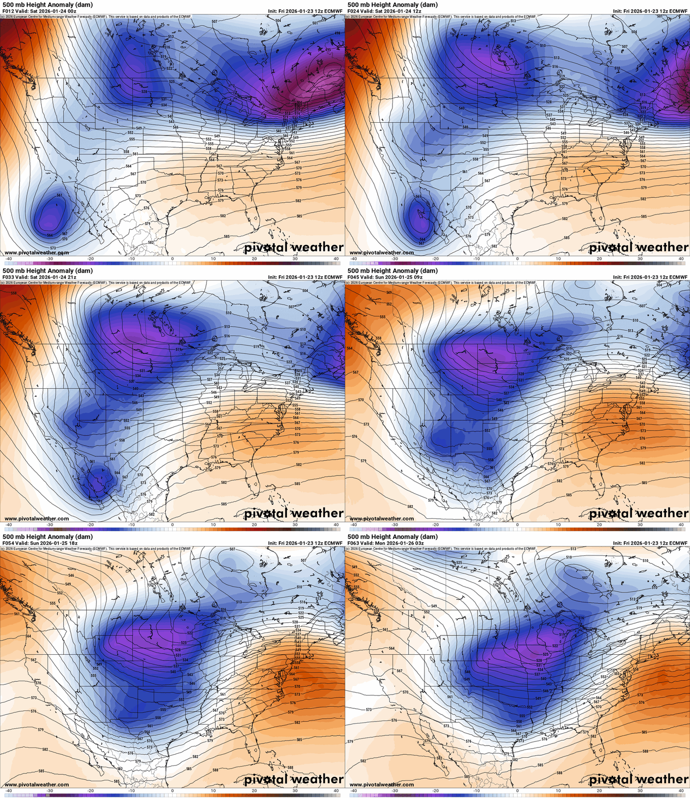
 From the NWS-Louisville conference call this afternoon.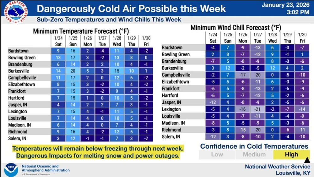
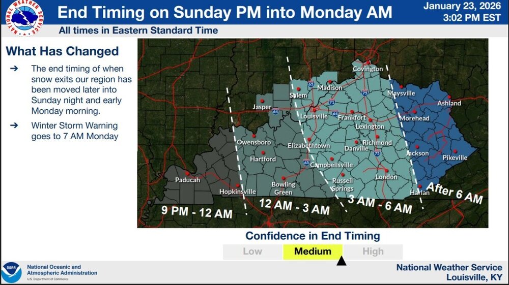
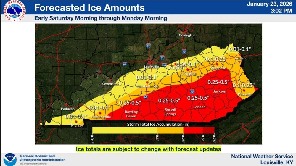
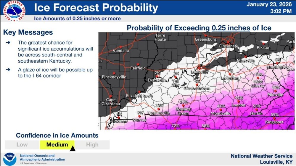
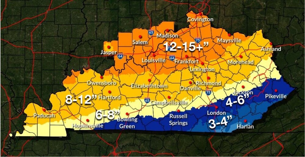
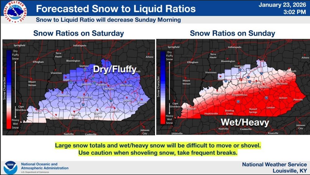
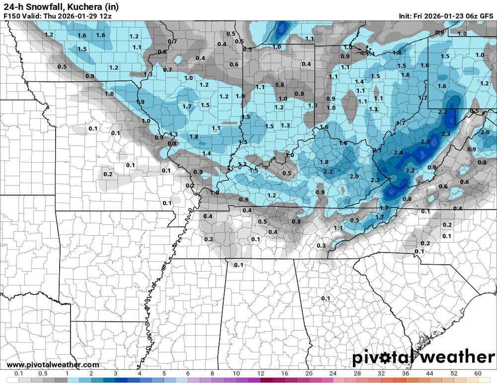
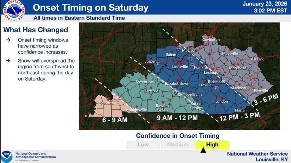 We may see more accumulating snow around the end of next week. A Alberta Clipper may pass through Kentucky next Thursday.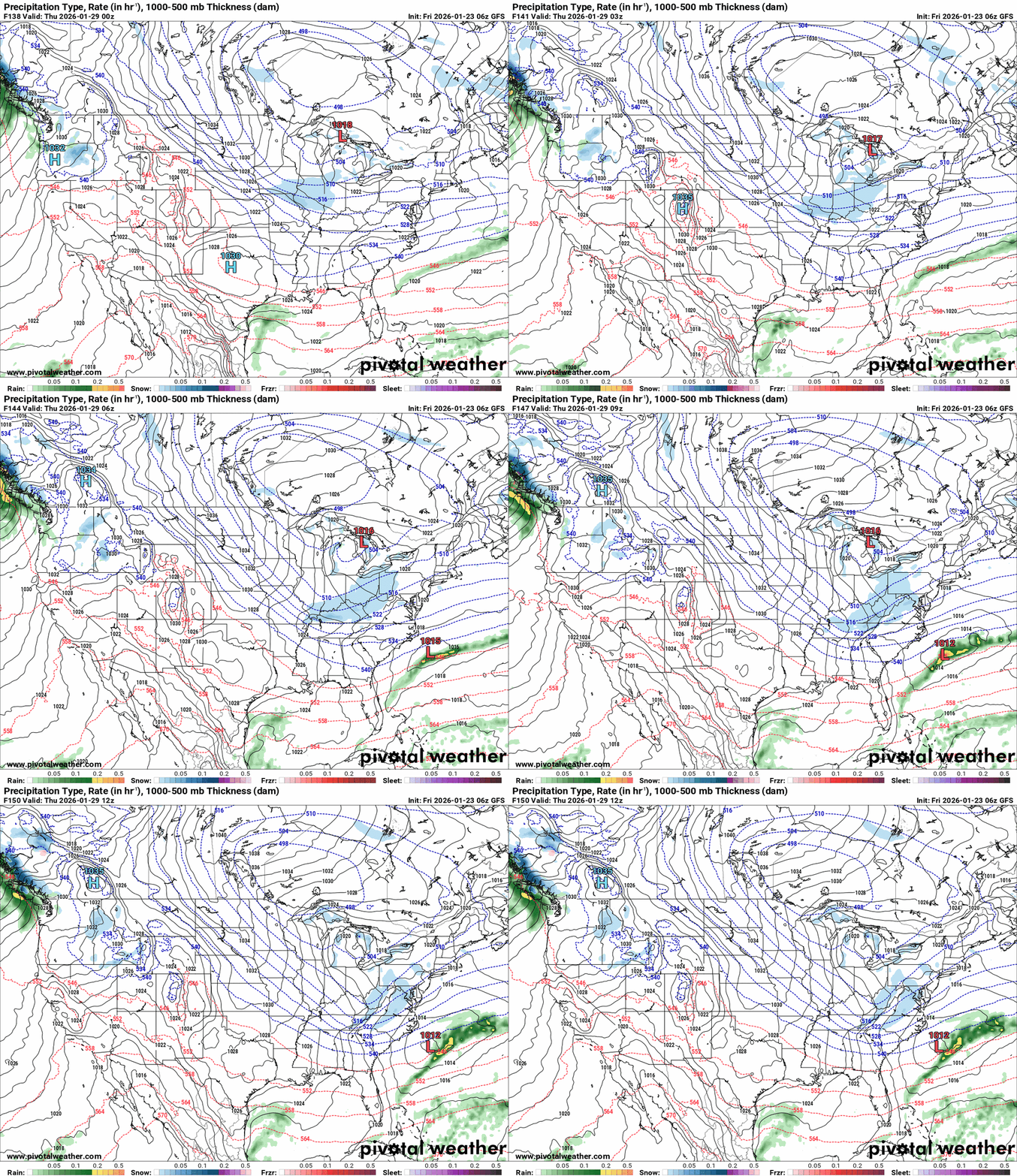











.png.feb355ef47a1a954d6b5867c78318c5f.png)