.png.ffa34568722b20f38e3c3ecfcb9a2cd2.png)


nWo
-
Posts
25,597 -
Joined
-
Last visited
-
Days Won
2
5 Followers

Recent Profile Visitors
17,613 profile views


-
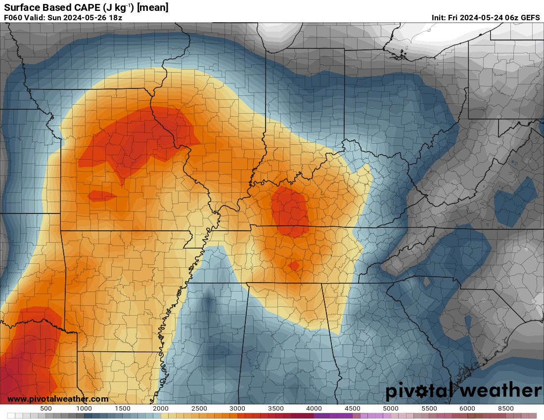
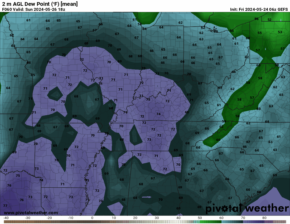
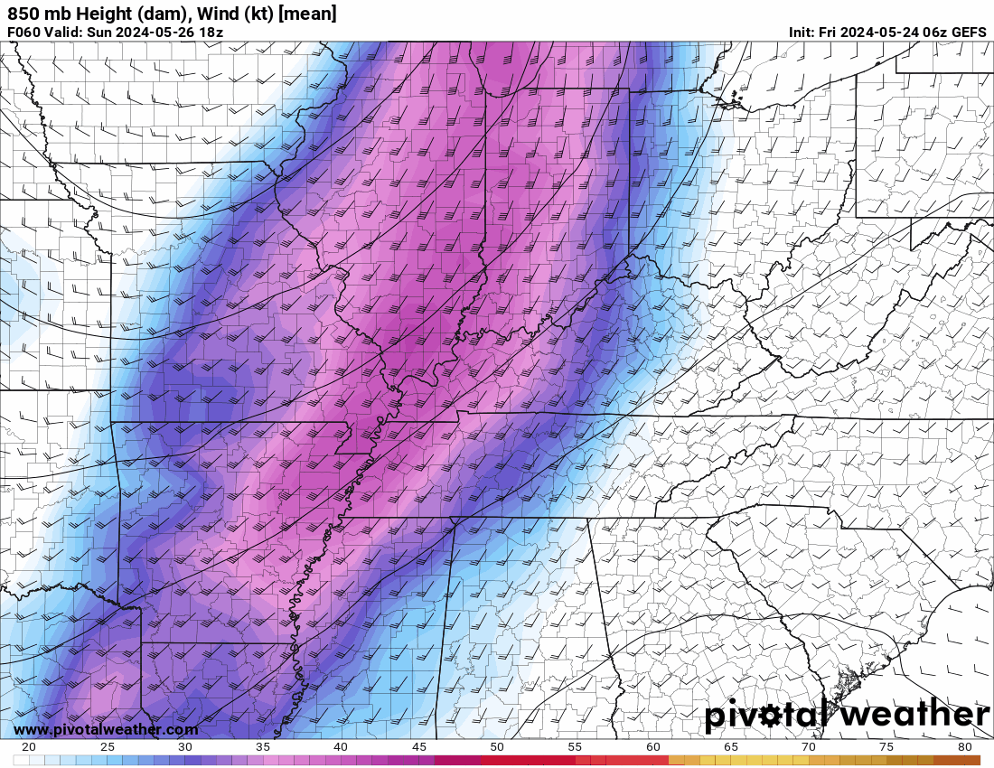
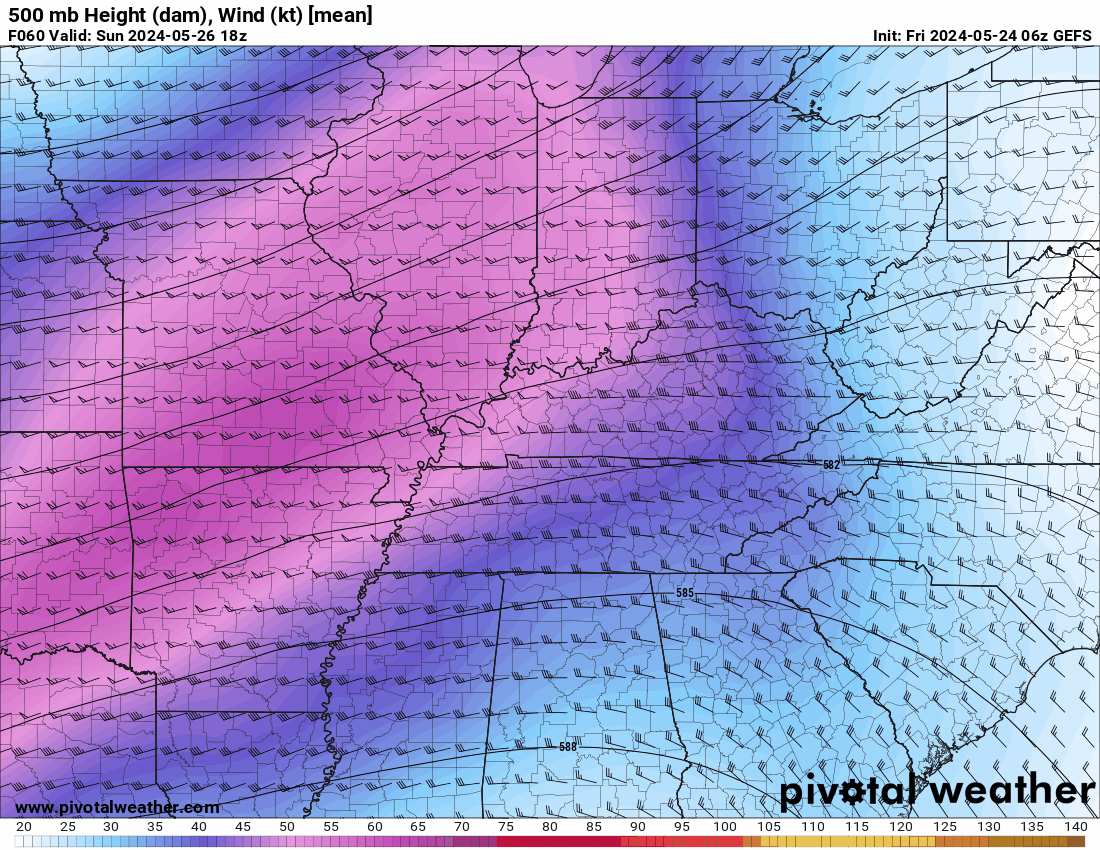
I just took a look at the GEFS Ensemble model. By producing several forecasts that, when applied to the data after it has been included in the model, yield a variety of possible outcomes, GEFS quantifies these uncertainties. Every forecast accounts for a unique combination of uncertainties. This is what it is showing for Sunday from 2 pm EDT to 7 am EDT Monday. First, surface winds are expected to blow from the southwest at a speed of 35 to 45 mph. Around 18,000 feet, there will be 50–60 mph westerly winds. It seems that the winds will have varying directions at various altitudes. This might lead to storms rotating and producing tornadoes. Additionally, Readings of 2,500 to 3,200 J/Kg (Joule per Kilogram)of surface-based CAPE. Generally, a CAPE of 1000 J/Kg is adequate for powerful to severe storms. Generally a CAPE of 3,000 to 4,000 J/Kg or above indicates an extremely volatile atmosphere. When combined with dew points that are expected to reach the mid-70s in western Kentucky and the low to mid-60s in the majority of the state, this could create an environment where all modes of severe weather will be possible from Sunday afternoon into the nighttime hours.

-
Just received this from the National Weather Service-Louisville
-
 nWo changed their profile photo
 -
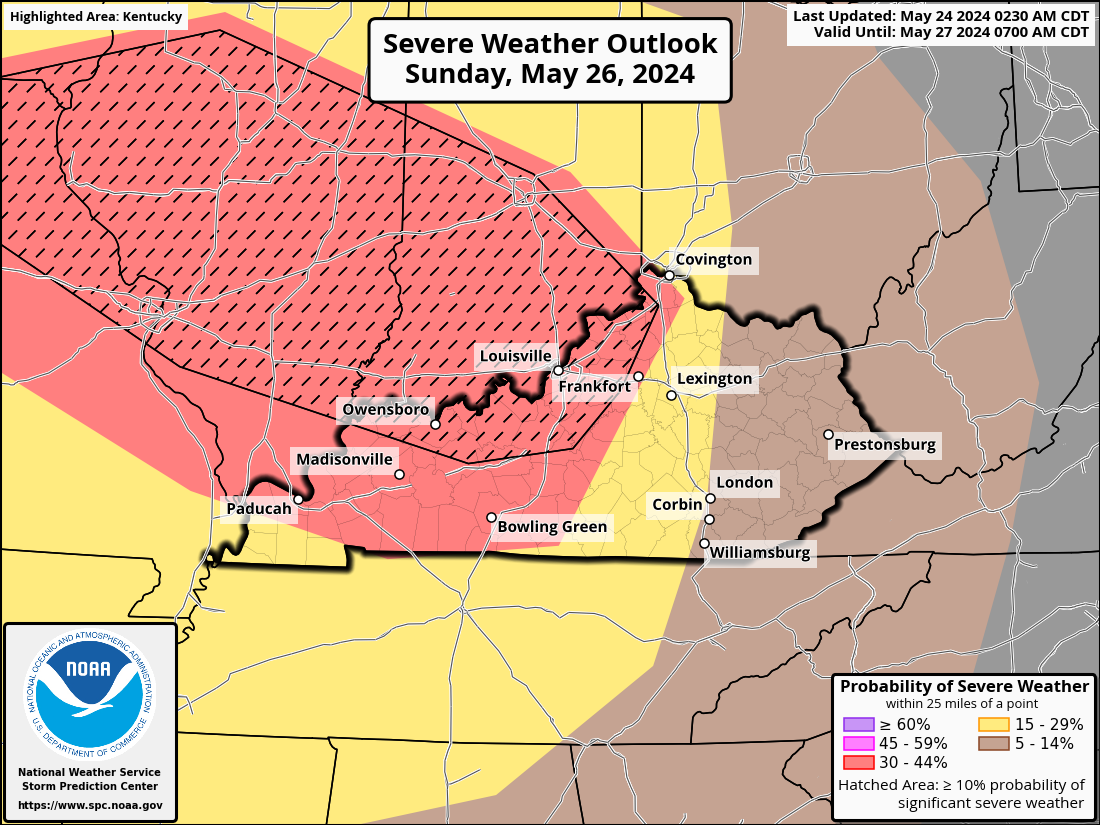
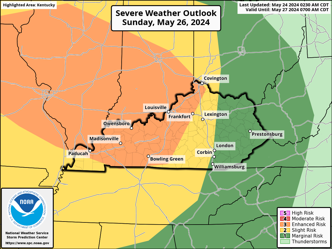
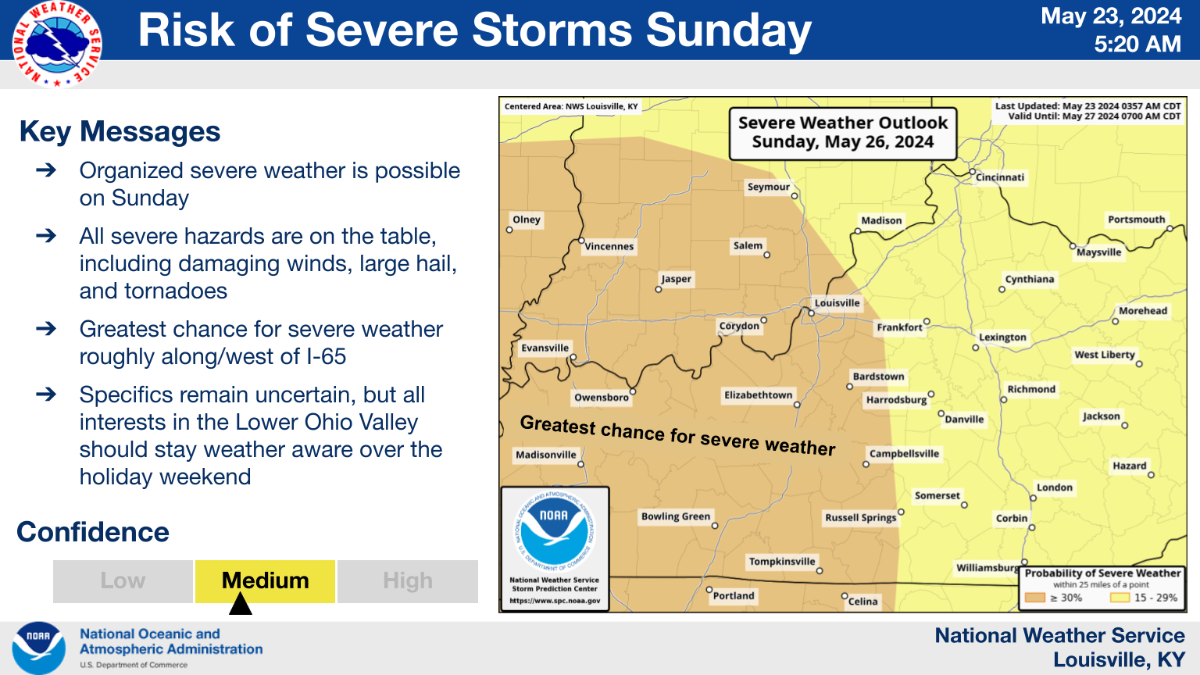
I will post information on this possible situation until late Sunday morning. My wife and I are scheduled to fly out of Lexington early that afternoon. ...THERE IS AN ENHANCED RISK OF SEVERE THUNDERSTORMS SUNDAY INTO SUNDAY NIGHT ACROSS PARTS OF SOUTHEASTERN IOWA...EASTERN MISSOURI...MUCH OF CENTRAL AND SOUTHERN ILLINOIS...MUCH OF CENTRAL AND SOUTHERN INDIANA...WESTERN AND CENTRAL KENTUCKY... Strong to severe thunderstorm development may accompany mid-level height falls across a potentially sizable area of the interior United States due to the significant potential instability associated with low-level moisture return through the warm sector of the developing cyclone, beneath at least initially capping elevated mixed-layer air. Due to variations in the model output on the synoptic and sub-synoptic developments—which might have included one or two significant clusters of convective development across the lower Missouri Valley at the beginning of the period—the specifics of this evolution are still unknown. By Sunday afternoon, there may be a concentration of convective activity again close to the point where the outflow meets the southward-moving cold front that is passing across the eastern Missouri and west central Illinois regions. The environment is expected to be favorable for supercells initially due to the large mixed-layer CAPE and strong shear. However, an upscale growing cluster will be supported by low-level warm advection along the remnant outflow, and it is expected to propagate southeastward across the lower Ohio and into Tennessee Valley until Sunday evening. The main severe weather hazards, such as a large hail/supercell tornado risk to damaging winds and possibly a persistent QLCS tornado threat, seem likely to center around the outflow boundary/differential heating zone, even though convection may gradually increase along the southward advancing front to the southwest of the outflow boundary. With this information, the Storm Prediction Center has a large section of Kentucky in a level 3 Enhanced Risk for Sunday. A portion of western Kentucky and around the I-75 corridor is in a level 2 Slight Risk area while eastern Kentucky is under a level 1 Marginal Risk.
-
We will remain on severe Severe Alert through Sunday. While we could see some severe weather on Friday, the best chance seems to be on Sunday.
-
-
I just received the following from the NWS-Louisville office.
- 1 reply
-
- 1
-

-
Isolated severe storms will be possible today from parts of the mid-Mississippi Valley northeastward into the Ohio Valley and Lower Great Lakes. Today, as a pre-frontal trough oriented from northeast to southwest moves eastward through the Ohio Valley, a shortwave trough will travel northeastward into the western Great Lakes. From the middle Mississippi Valley northeastward to the lower Great Lakes, a short corridor of instability will form close to the pre-frontal trough. Isolated to dispersed thunderstorms are predicted to start when the front's surface temperatures rise during the day. During the afternoon, it is anticipated that many thunderstorm clusters will form and proceed eastward across the Ohio Valley. The environment will be favorable for the possibility of organized severe storms. Storms may have a propensity to organize into brief line segments despite the possibility of supercells because of flow that is parallel to the convective axis. Wind-related damage will be the primary threat, although hail and a marginal tornado threat will be possible in the lower Great Lakes, where deep-layer shear is forecast to be the strongest. The severe threat could persist into the early evening, as cells move into the central Appalachians.
- 1 reply
-
- 1
-
-
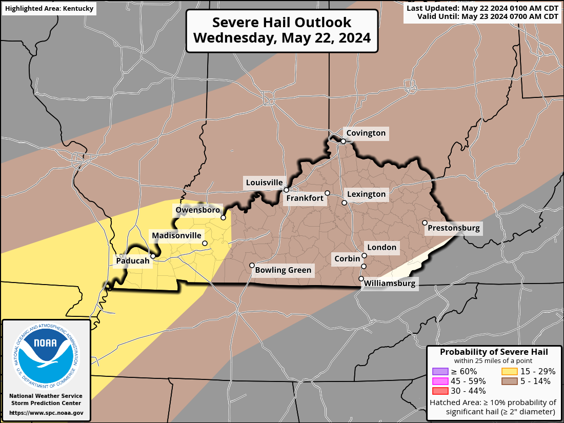
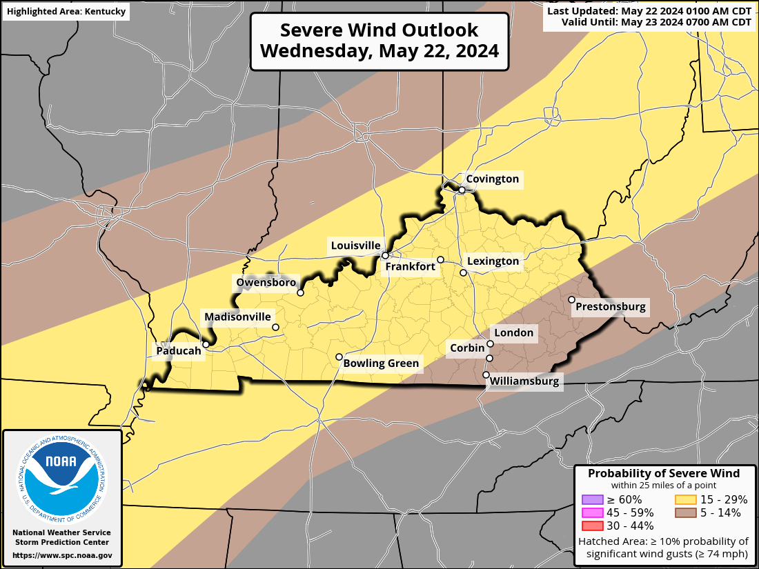
On Wednesday, there is a chance of severe thunderstorms with hail and destructive gusts from northern Texas to the Ohio Valley and lower Great Lakes region. Large to extremely large hail and damaging gusts are most likely to occur from north Texas to the Missouri Bootheel area. The eastward-moving cold front and any MCVs from Tuesday's leftover convection on Day 1 will be the main factors causing the ascent in the area. These will be floating in the southwesterly flow. Over IN, OH, and KY, there will be a humid airmass with mid-to upper-60s dewpoints. This airmass will stretch northeast into NY/PA and the neighboring states in the low- to mid-60s. In the late morning and afternoon, moderate instability will be facilitated by a plume of steep midlevel lapse rates and significant heating. Cells that are organized will only need a minimal amount of vertical shear. Small hail and intermittently strong gusts of destruction are possible during thunderstorms.
-
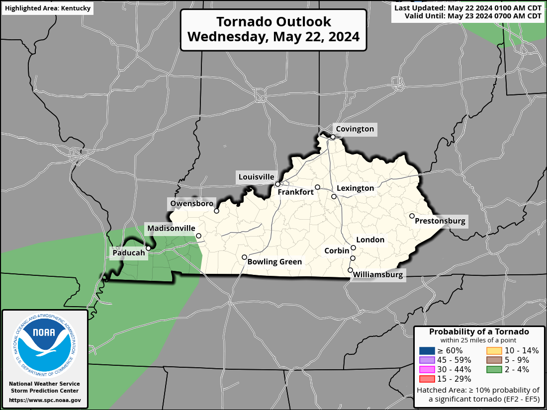
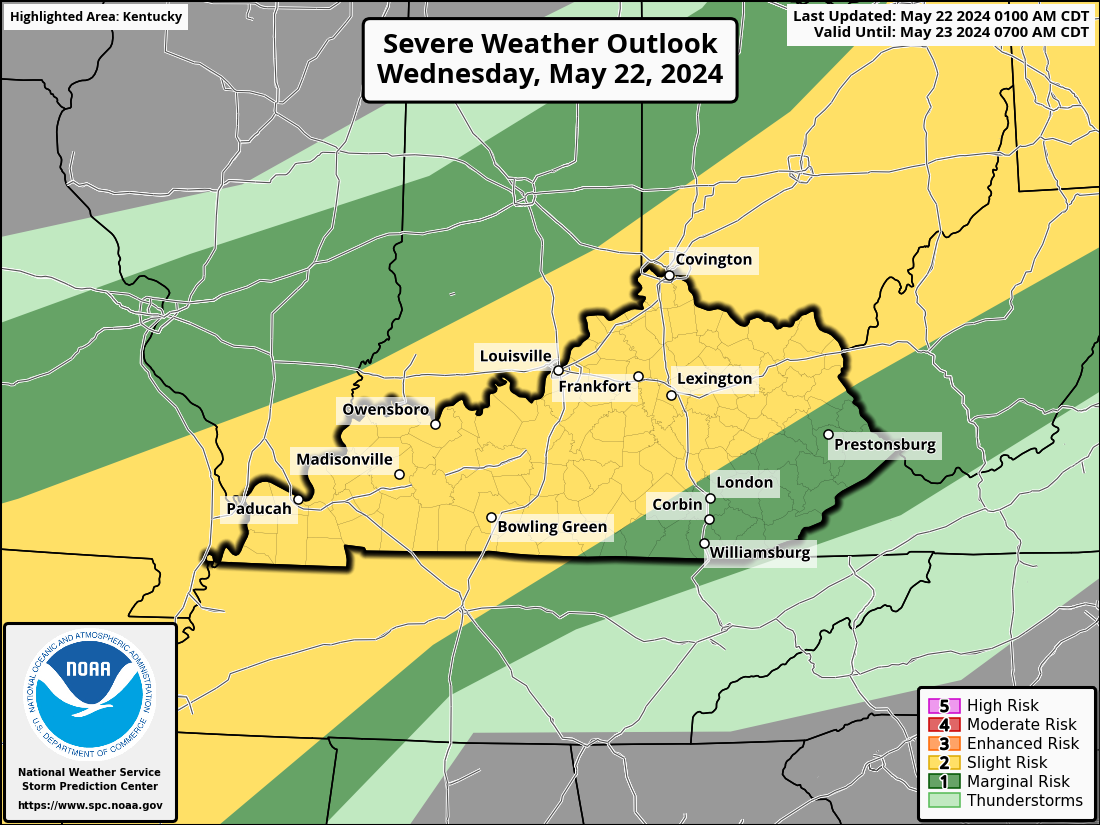
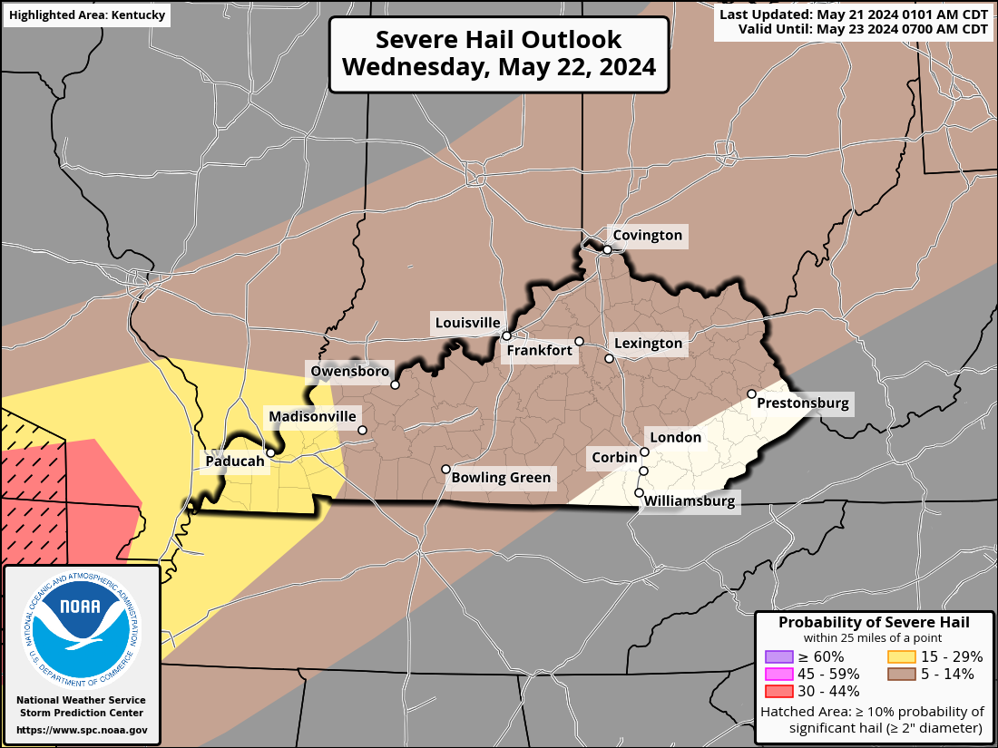
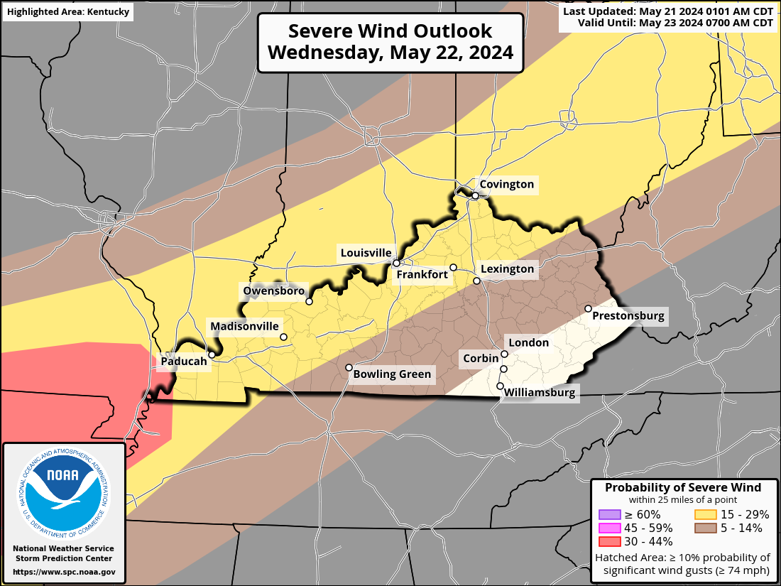
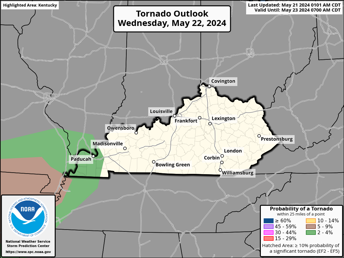
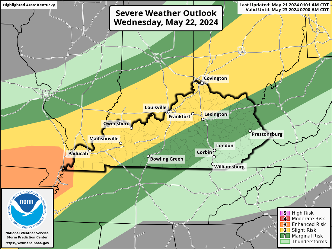
On Wednesday, an upper low over the Upper Midwest will move across the Great Lakes and into Ontario to the east and northeast. There will be a sustained strengthened mid/upper southwesterly flow over a large section of the region. Strong low pressure over Minnesota and Wisconsin will occlude at the surface and gradually turn northeasterly and north into Ontario. A cold front is expected to move eastward over Lower MI, IL, and IN, while the boundary's southernmost point either stalls or moves slightly northward from southern MO into Oklahoma and northwest Texas. Along the cold front, convection might still be going on Wednesday morning. During the day, destabilization would be happening ahead of the boundary across the Ohio Valley. Convective evolution is less certain further south. Nonetheless, an extremely humid and erratic airmass is anticipated. It is possible for thunderstorms to continue during the morning and continue. There is still some doubt about the specifics, but given the existence of a surface boundary, enough vertical shear, and a moist/unstable boundary layer, a corridor of severe potential seems likely. With this information, The Storm Prediction Center has sections of Kentucky, WKY along the Ohio River to the Cincinnati area, with a % chance of strong to severe storms on Wednesday.
-
WKU will close it's campus at 1 pm CDT
-
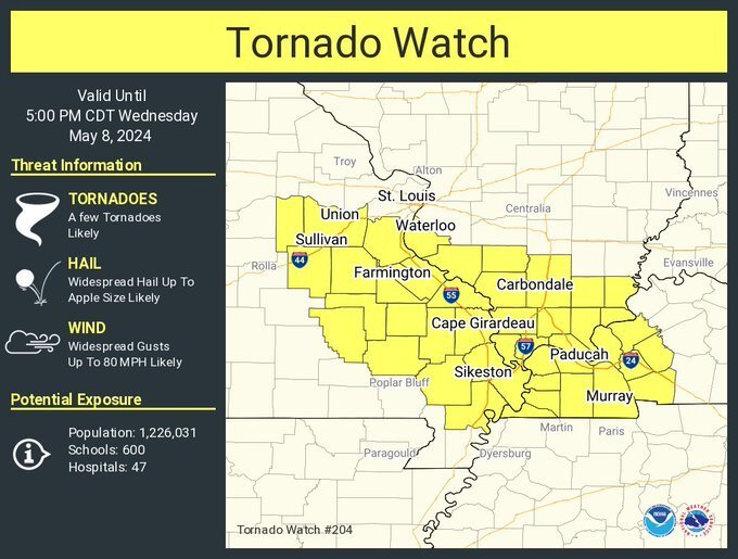
URGENT - IMMEDIATE BROADCAST REQUESTED Tornado Watch Number 204 NWS Storm Prediction Center Norman OK 1025 AM CDT Wed May 8 2024 The NWS Storm Prediction Center has issued a * Tornado Watch for portions of Southern Illinois Western Kentucky Southeastern Missouri * Effective this Wednesday morning and afternoon from 1025 AM until 500 PM CDT. * Primary threats include... A few tornadoes likely with a couple intense tornadoes possible Widespread large hail and scattered very large hail events to 3 inches in diameter likely Widespread damaging winds and isolated significant gusts to 80 mph likely SUMMARY...A supercell cluster in Missouri will likely persist through the afternoon while spreading east-southeastward toward southern Illinois, southeastern Missouri and western Kentucky, with some potential for additional storm development this afternoon. The environment will become more favorable for surface-based storms capable of producing tornadoes (a couple of which could be strong/EF2+), severe wind swaths up to 80 mph, and very large hail of 2-3 inches in diameter. The tornado watch area is approximately along and 45 statute miles north and south of a line from 5 miles south of Vichy MO to 40 miles east of Paducah KY. For a complete depiction of the watch see the associated watch outline update (WOUS64 KWNS WOU4). PRECAUTIONARY/PREPAREDNESS ACTIONS... REMEMBER...A Tornado Watch means conditions are favorable for tornadoes and severe thunderstorms in and close to the watch area. Persons in these areas should be on the lookout for threatening weather conditions and listen for later statements and possible warnings.
-
Some school systems are starting to dismiss schools early today.
-
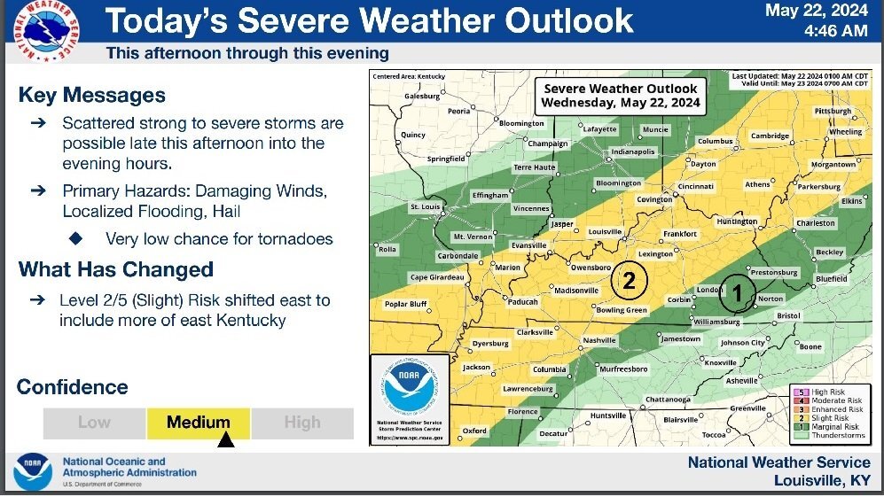
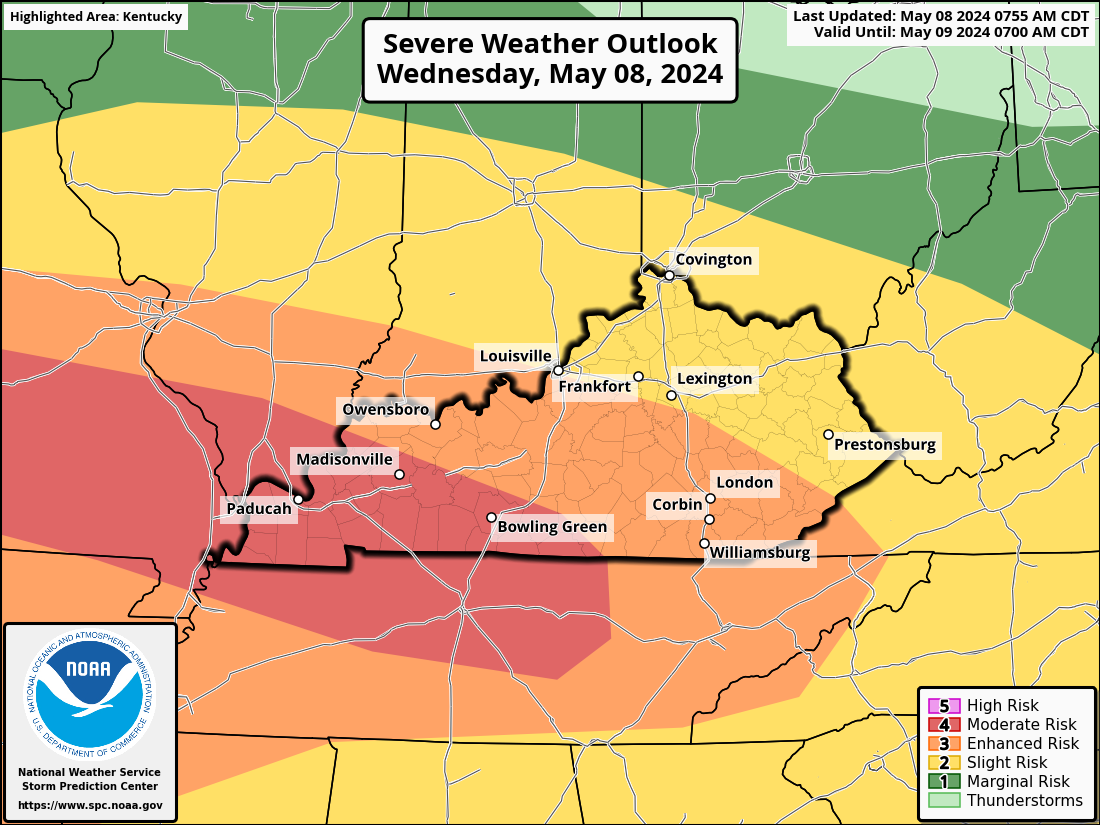
The level 4 Moderate Risk area now includes Madisonville and Bowling Green.