.png.ffa34568722b20f38e3c3ecfcb9a2cd2.png)

.jpg.dff87640c6ed93f4bdf8eebdf96f5dec.jpg)
nWo
-
Posts
25,628 -
Joined
-
Last visited
-
Days Won
5
5 Followers

Recent Profile Visitors
17,916 profile views


-
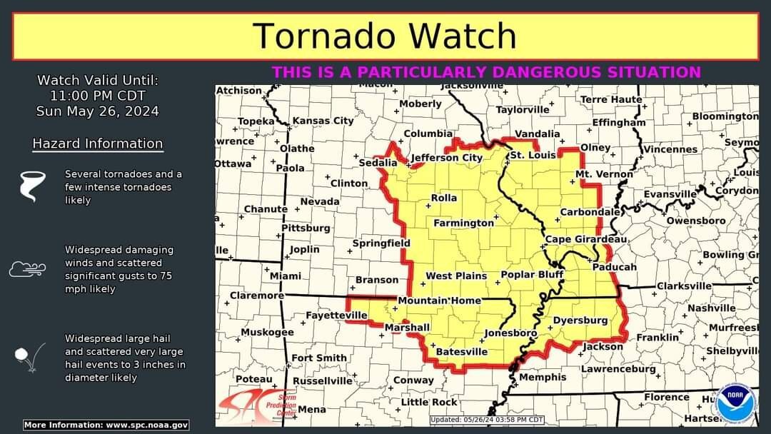
From the NWS-Louisville office, Correction to the statewide tornado count from May 26: There were a total of 14 tornadoes Sunday in the Commonwealth of Kentucky. The earlier count had not included the one that NWS Jackson confirmed near Corbin. Western Kentucky did have an EF-3 and an EF-2, while the remaining 12 tornadoes were all rated EF-1.
-
My daughter told me, my wife, today that the tornado in Warren County was headed for her subdivision but lifted just before it got there. She said she could hear it, and it sounded like a train heading in her direction.
-
Thank you both!
-
I forgot to mention that it was coming in from Vegas that's why it ran short of fuel.
-
Mine circled in that area northeast of Lexington then it had to divert to Huntington for fuel.
-
I just received a message from my daughter that she thought it was a tornado because it sounded like one.
-
The damage near my daughter's house has been rated, at least EF-1 by the NWS-Louisville office.

-
The survey in Northern Warren County is close to where Plum Springs is.
-
Damage at my daughter's house. She lives in Plum Springs.
-
My daughter sent me these pictures of damage near Plum Springs, which is just north of Bowling Green.
-
.thumb.jpg.dc448957daf4ddf2823660190e844abb.jpg) nWo changed their profile photo
nWo changed their profile photo -
Everyone be safe! We finally made it to Vegas.
-
They were circling around around cynthia eky and the like trying to wait out the storm and started running low on fuel.
-
I'm sitting at bluegrass field. The second round of storms will start around 8 pm edt. Round #1 is over. ➔ Round #2 will begin around 8pm ET (7pm CT). ◆ Individual storms will develop over Western Kentucky and southern Indiana and congeal into a line moving southeast through the region. ➔ Expecting widespread damaging winds, spin-up tornadoes and hail. ➔ Flash flooding, especially over south-central Kentucky. Another 1-3 inches of rainfall, with locally higher amounts possible.