.png.ffa34568722b20f38e3c3ecfcb9a2cd2.png)


nWo
-
Posts
25,704 -
Joined
-
Last visited
-
Days Won
5
5 Followers

Recent Profile Visitors
19,095 profile views


-
It is possible that a storm will form in the gulf immediately off the Yucatan Peninsula by the end of the next week. Predicting anything this far out is difficult, but the latest GFS suggests that a large hurricane might form and move toward Florida's west coast. I noticed this since last year, at this same time, my wife and I were taking a cruise in this same area. The National Hurricane Center in Miami, Florida, indicates that there is currently a 40–60% chance that a system may form by the middle of next week. The models have shown a marked increase in this potential system's strength since the beginning of this week. If anyone has a cruise planned, they might want to keep a close eye on this system. From the National Hurricane Center Miami, FL:

-
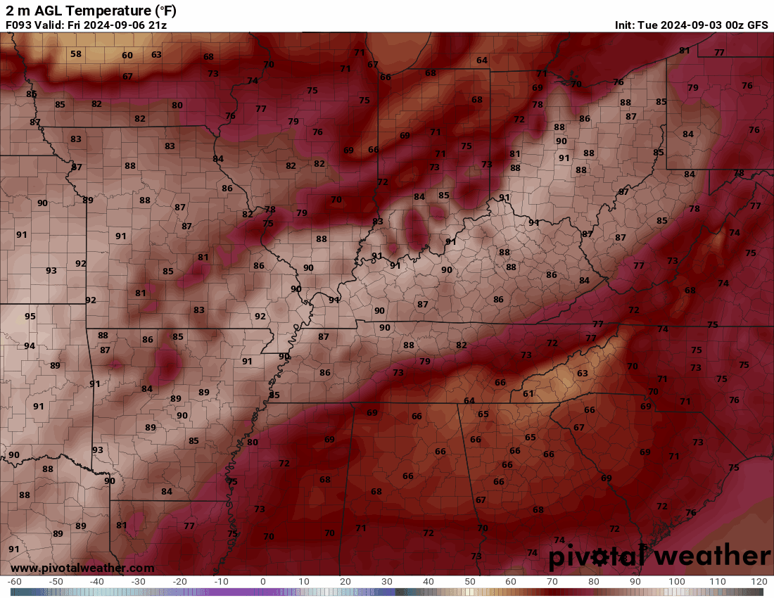
According to this forecast, the state of Kentucky will have temperatures ranging from the low 90s in the west to the mid to upper 80s in the east. At most, they should drop to the mid- to upper-60s in Kentucky's eastern region and to the low to mid-70s in the state's western region. It will remain mostly dry for the games.
-

Remnants of Tropical Storm Francine to affect Kentucky this weekend
nWo replied to nWo's topic in KY Football (High School)
The totals are through 2 am EDT Saturday morning.
-
Francine is now a hurricane. Excessive Rainfall Discussion NWS Weather Prediction Center College Park MD 1203 PM EDT Wed Sep 11 2024 Day 3 Valid 12Z Fri Sep 13 2024 - 12Z Sat Sep 14 2024 ...A MARGINAL RISK OF EXCESSIVE RAINFALL EXISTS ACROSS PORTIONS OF THE MID-SOUTH AND SOUTHEAST... A broad Marginal Risk of excessive rainfall exists for portions of the Mid-South and Southeast with the weakening extratropical/Post- Tropical Cyclone Francine. The guidance isn't showing a great deal of overlap in potential heavy rain areas, so left the risk area as-in, but in theory, portions of northern FL and the Southeast, possibly including the southernmost Appalachians, have potential for hourly rain totals to 2.5" and local amounts of 5" as enough instability and low- level inflow/effective bulk shear exists for possible issues. Should the guidance align on this idea QPF-wise further, a Slight Risk could be added in later cycles.
-
Francine is expected to strengthen into a hurricane later today.
-
Excessive Rainfall Discussion NWS Weather Prediction Center College Park MD 327 AM EDT Tue Sep 10 2024 Day 3 Valid 12Z Thu Sep 12 2024 - 12Z Fri Sep 13 2024 ...A SLIGHT RISK OF EXCESSIVE RAINFALL EXISTS FOR THE MID-SOUTH... Mid-South/Southeast... Francine is expected to be fully extratropical, with a well- developed comma head and trailing front. Guidance suggests that MU CAPE will be modest, 250-500 J/kg. Effective bulk shear should continue to be sufficient for convective organization where enough instability develops/exists. Precipitable water values remain near 2", so hourly rain totals up to 1-2" should be possible, which would be most problematic in urban areas and initially beneficial elsewhere. This region has been quite dry lately. With the volume of rain expected, and the concept of this being on the cusp of a flash flood and longer duration flood event, kept the Slight Risk area which showed minimal change from continuity. Across the Southeast, there is a risk of training convection along Francine's cold front, but its progression is expected to limit issues. Still, hourly rain totals to 2" and local amounts to 4" should be possible.
-
The remnants of Francine are expected to reach Kentucky around Thursday night. Over two inches of rain might fall by Friday due to heavy precipitation and potential thunderstorms, mostly in western Kentucky. There will be an additional inch possible along I-75. Thunderstorms will also be possible on Friday.
-
nWo changed their profile photo
-
The remnants of Francine are expected to reach Kentucky around Thursday night. Over two inches of rain might fall by Friday due to heavy precipitation and potential thunderstorms, mostly in western Kentucky. There will be an additional inch possible along I-75. Thunderstorms will also be possible on Friday.
-
Thunderstorms will be possible today into tonight. A few strong to marginally severe storms may occur, with the main time frame being between 2 PM and 8 PM. Damaging winds are expected to be the main threat, although marginally large hail may also occur.
-
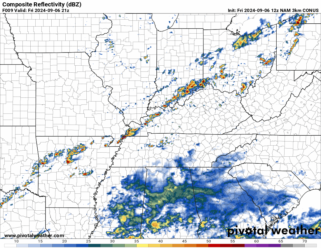
Thunderstorms will be possible today into tonight. A few strong to marginally severe storms may occur, with the main time frame being between 2 PM and 8 PM. Damaging winds are expected to be the main threat, although marginally large hail may also occur. There is a level 1 Marginal Risk for isolated strong to severe storms from I-64 northward. This radar is from 5-11 pm EDT
-
Scattered showers and thunderstorms are possible Friday evening. Timing is still uncertain, along with exact location of the precipitation.
-
Tuesday update: No real change in the outlook. There is a 40% chance of precipitation mainly around the Ohio River area.
-
Expect temperatures in the high 80s and low 90s. By the end of most of the games, they will fall to the mid-70s. At the time of this post, possible precipitation is forecast to be mainly west of I-65.
-
Severe thunderstorms, associated with severe wind gusts and hail, will be possible today from parts of the central Appalachians into the Ohio and Tennessee Valleys. An upper-level trough will move through the Great Lakes region, with the southern end of the trough located in the mid-Mississippi Valley. An associated cold front will advance southeastward through the mid-Mississippi Valley and southern Great Lakes. Ahead of the front, a moist airmass will be in place with surface dewpoints in the upper 60s and lower 70s F. Moderate instability is expected to develop by midday ahead of much of the front. Further to the east, a pre-frontal trough will be located from western New York and western Pennsylvania southwestward into eastern Kentucky. Scattered thunderstorms will form from near the front eastward to near the pre-frontal trough. By early to mid-afternoon, conditions will support severe wind gusts with the more organized bowing line segments. Hail will also be possible.