

nWo
BGP Meteorologist
-
Joined
-
Last visited
Everything posted by nWo
-
On Friday morning, the first light snowfall is predicted to occur in southern Indiana and northern Kentucky between 4 and 10 AM EST. There is a high likelihood that there won't be much snowfall—between a dusting and half an inch. Slick spots may have an impact on the Friday morning commute, even in small amounts. There will be another snowfall on Friday night and into Saturday. Once more, some might notice a dusting to one. On Friday morning, there will be wind chills in the mid-teens and temperatures in the mid-20s. The starting temperature on Saturday should be in the low to mid-30s. The low 20s will be the range of windchills.
-
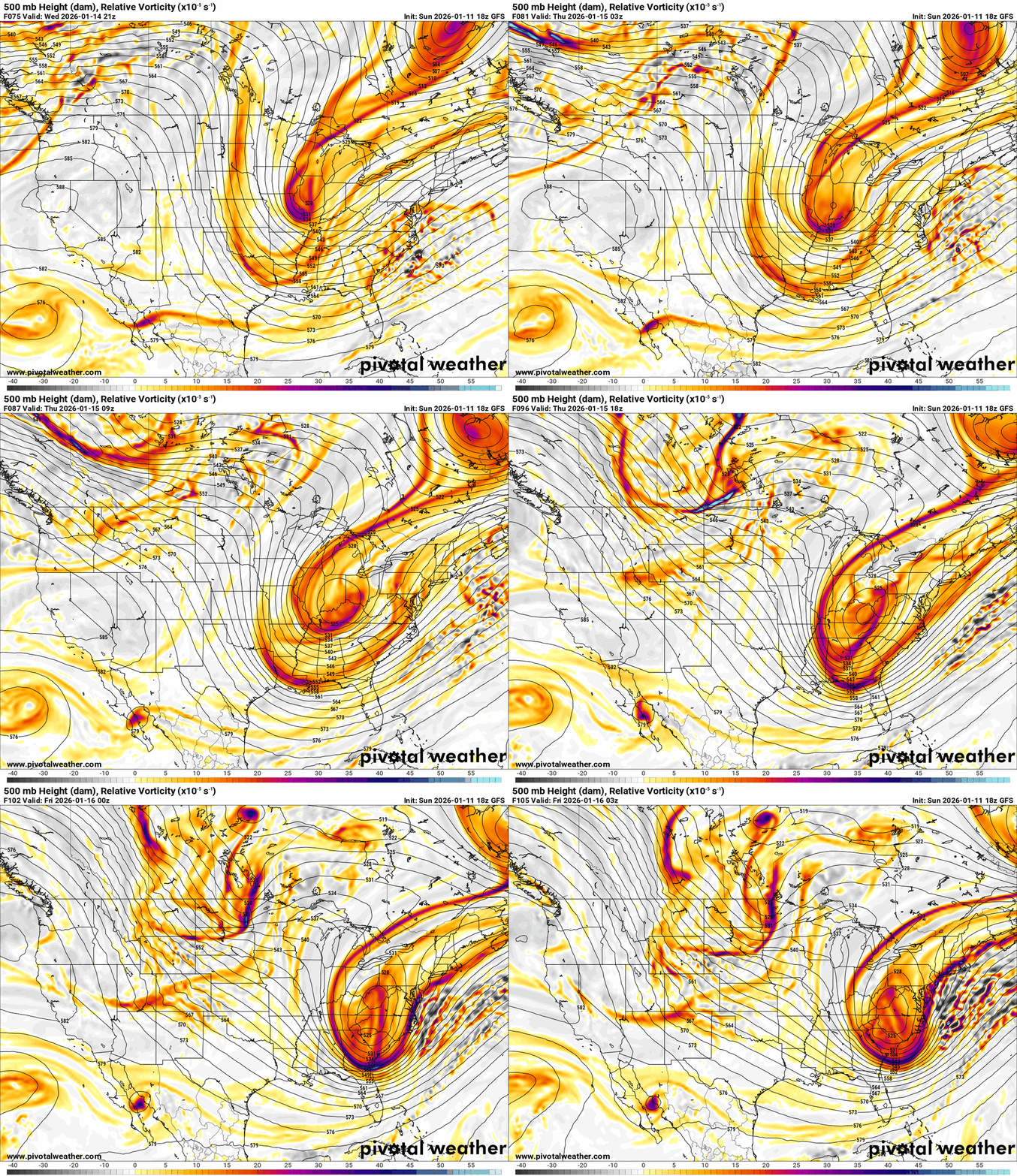
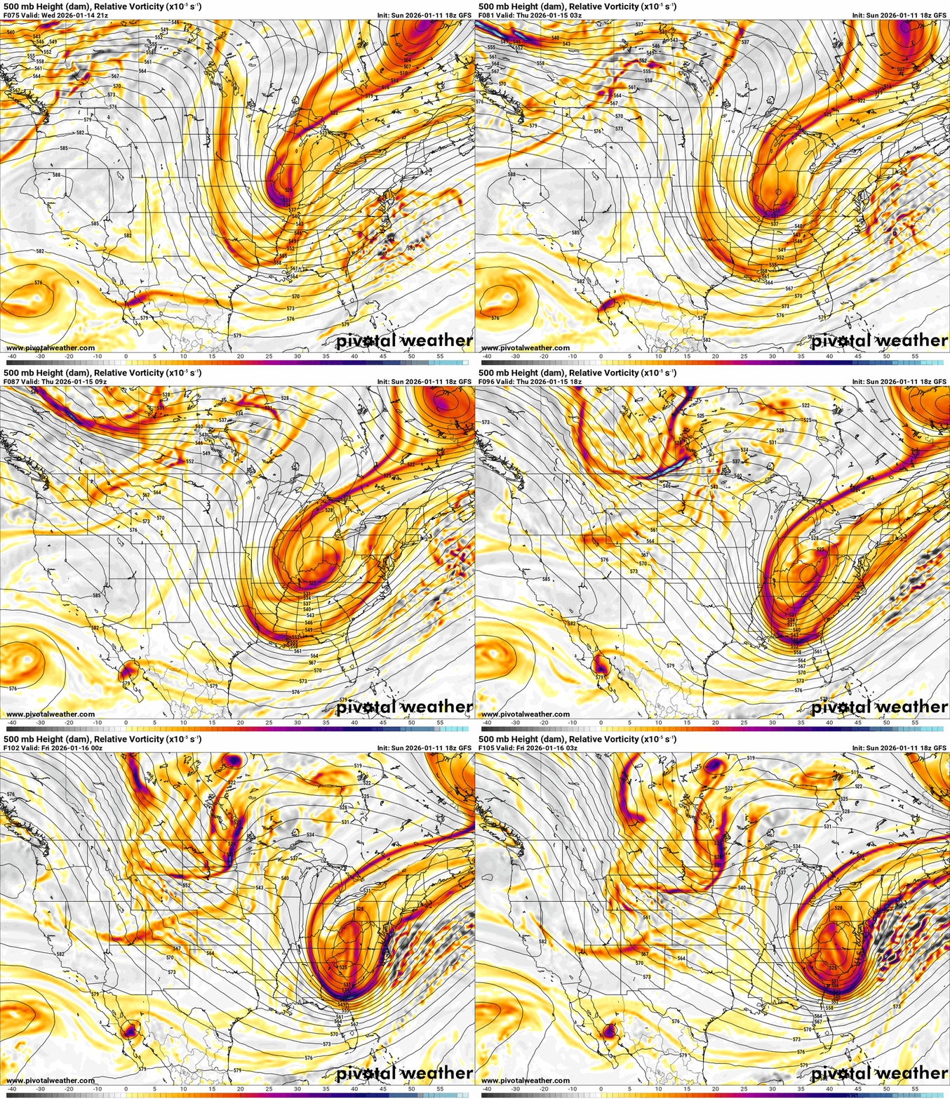
If you watch some weather forecasters on YouTube, you may see some posting about a significant snowstorm next week. So let me show what they may be talking about. Then I'm going to show you another map from the same GFS model. The first one is from yesterday afternoon's 18z run. It shows a possible blizzard for the Ohio Valley. If this were to come to pass, it would completely shut down the Ohio Valley. Now, this is what the same model was showing for the same time period on last evening's 00z run. The signal is there for possible snow next week. We'll just have to wait and see.
.thumb.png.ba97894020b2d3635cd9f79cc01d9d07.png)
.thumb.png.1f12a1efa78e80ba9196161b2d20d585.png)
-
The cold will be the story over the weekend. For the first system, I'm thinking a dusting to 1" for those around I-75 eastward. Portions of southeast Kentucky could see 1-3, especially in the mountain areas.
-
I'll post how much snow we may get after this first system in the morning. I'm not really expecting much. I'm not expecting much for the systems this weekend. I have just looked for the possible next system that may produce wintry weather for our area next weekend. It looks very interesting.
-
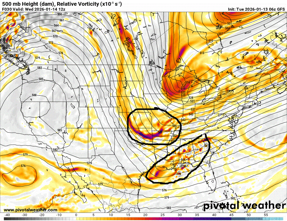
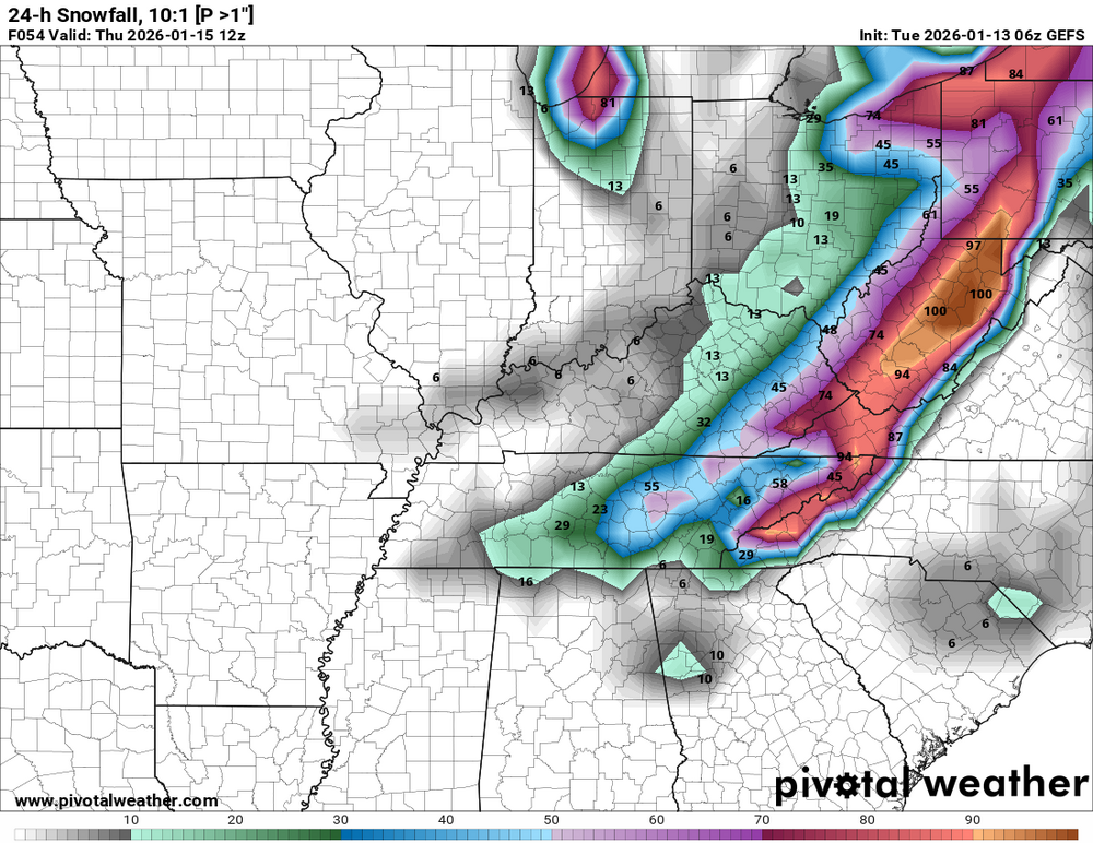
Snow chances are trending down from Wednesday night into early Thursday. Earlier models showed two weather systems combining over Kentucky, which would have produced more snow. New data now shows those systems staying separate. One system moves in with a cold front that may change rain to snow, while the other tracks farther south and moves out ahead of it. Because they won’t merge, snowfall amounts should be lower. Any accumulating snow will be spotty, with the best chance in eastern and southeastern Kentucky—mainly east of I-75 and south of I-64.
-
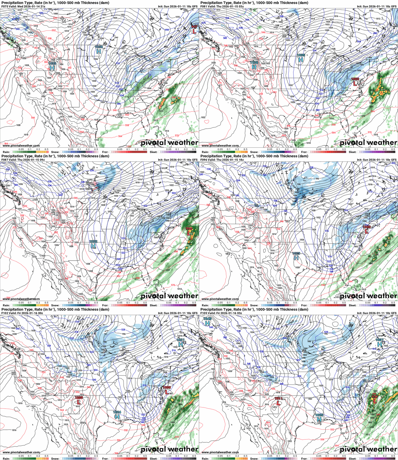
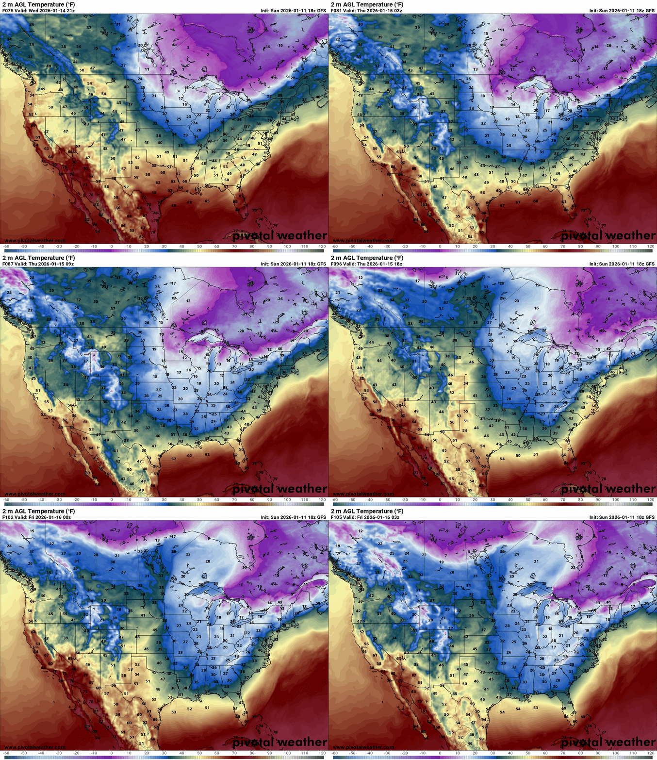
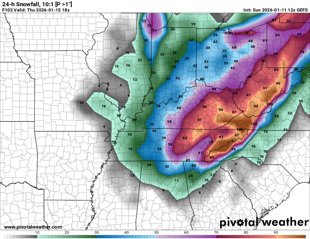
By the middle of the week, a trough will move southeasterly and get close to Kentucky. Rain is expected on Wednesday as it approaches Kentucky. An upper-level low will develop late on Wednesday as the trough approaches Kentucky. A deep pocket of cold air (upper-level low) will turn the rain into snow as it intensifies. As the low slowly moves eastward out of Kentucky, the likelihood of snowfall will begin to decrease. The GFS is the source of this data. The GEFS Ensemble model indicates that the best chance of seeing any accumulation is primarily east of I-65. As of this evening, the Euro is not displaying this system, so there is still a great deal of uncertainty regarding this potential winter event. This is different from what it displayed yesterday. As we approach, more clarity will become apparent. Another thing to be aware of. On Sunday, there might be another chance of snowfall to cap off the forthcoming weekend. PreferPay®.pdf Safeco_251124_121806.pdf
-
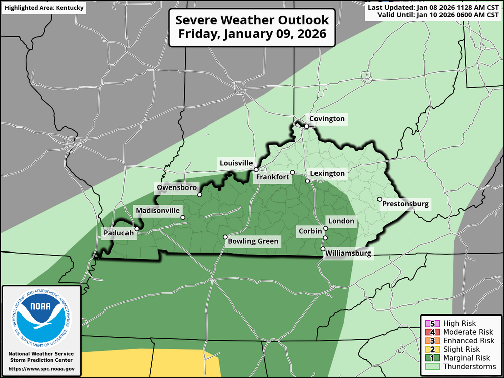
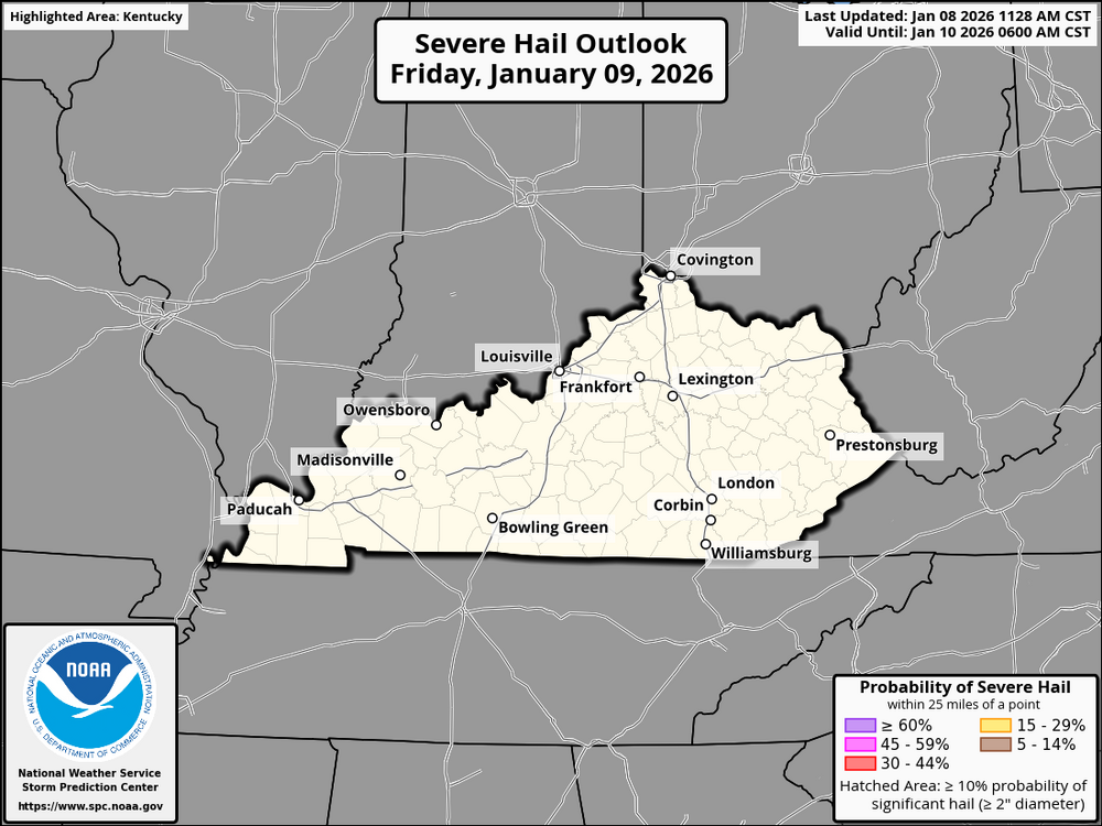
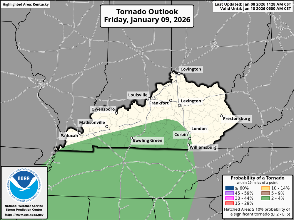
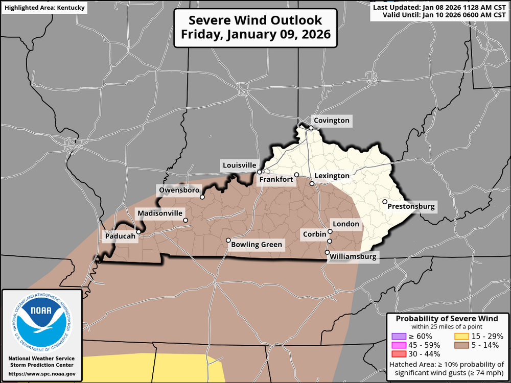
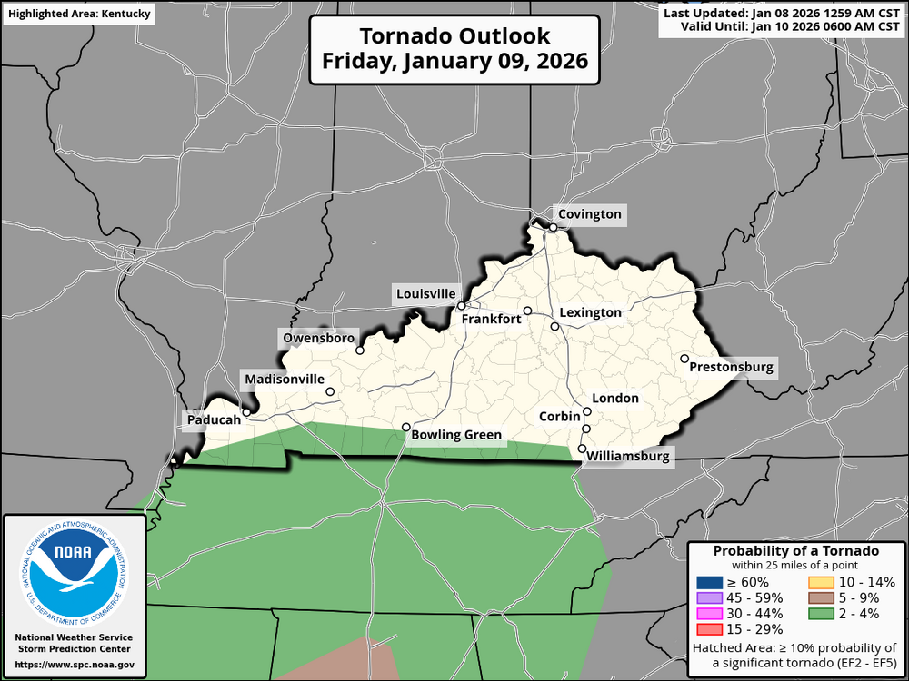
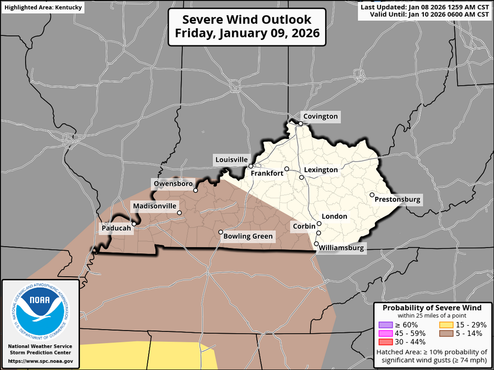
Storms are possible across Kentucky Friday afternoon into Friday night, mainly moving through as lines or clusters. The primary concern is the potential for strong to potentially damaging wind gusts, along with heavy rain and frequent lightning in stronger storms. The tornado risk is low, though a brief or weak tornado can’t be completely ruled out, especially in western or southern Kentucky. Kentucky is not the main target area for severe weather, but a few storms could still be strong, so stay weather-aware Friday evening and overnight.
-
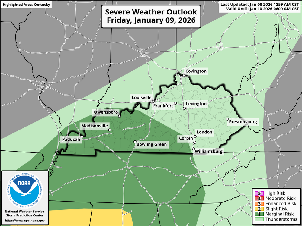
Stronger thunderstorms are more likely to occur in western Kentucky than in the state's eastern region. There is a chance that storms will arrive late in the afternoon or early evening, bringing with them strong winds and short bursts of heavy rain. Although it is impossible to completely rule out a few severe storms, the overall risk is still minimal because the strongest dynamics and better instability remain south of the area. In western Kentucky, there is very little chance of a tornado. Rain and sporadic thunderstorms are predicted for Eastern Kentucky, with storms coming later and probably being weaker. Storm intensity should be limited by cooler air, less instability, and nighttime timing. In eastern Kentucky, severe weather is unlikely, and the main effects should be periods of rain with some thunder. Although this does not appear to be a high-end severe weather day for the state, western Kentucky should generally be more weather-aware than eastern Kentucky.
-
A significant weather shift is heading toward the Ohio Valley. While the start of the week was quiet, a developing storm system is moving in from the Plains, bringing a rare surge of spring-like moisture and a risk of severe storms for Friday and Friday night. Activity begins Friday morning, but the primary threat for severe weather increases late Friday afternoon and intensifies after dark. The main hazards are high-speed winds and organized storm clusters. A strengthening low-level jet creates a threat for damaging winds and the potential for a few tornadoes. Unusually high humidity (dewpoints in the 60s) will act as fuel for these storms as they move through Kentucky. WHAT YOU SHOULD DO: STAY ALERT: Since the greatest threat is forecast for Friday night, make sure your weather alerts are loud enough to wake you up. SECURE ITEMS: High winds can easily toss patio furniture or loose outdoor decorations. Move them inside by Friday afternoon. MONITOR UPDATES: Forecast confidence is currently 2 out of 5. Models are still narrowing down exactly where the strongest part of the line will hit. Stay safe and stay weather aware!
-
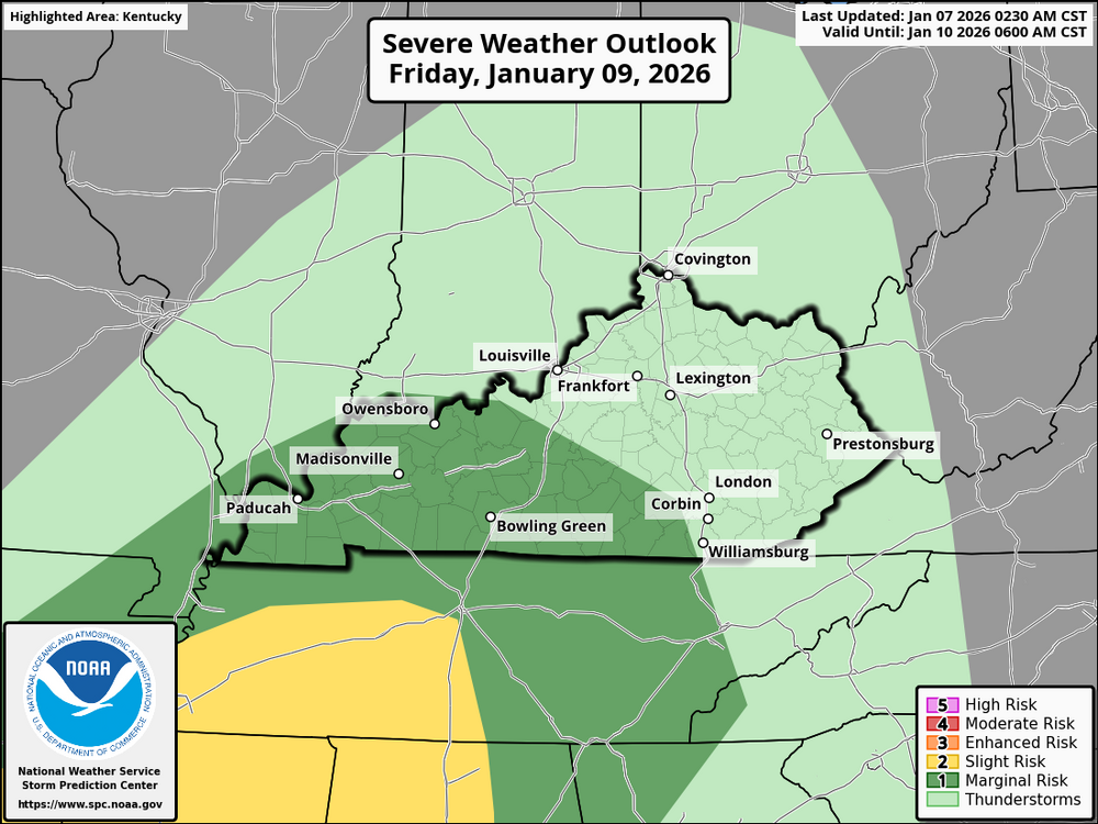
The Storm Prediction Center has placed portions of western and central Kentucky at a Slight Risk (15%) for severe thunderstorms on Friday. The severe weather threat is expected to develop Friday afternoon and continue into Friday night. The greatest potential is currently focused over western Kentucky, with the warm sector potentially extending east into south-central and central Kentucky west of I-65 and possibly north toward the Ohio River. Storms are expected to organize mainly as lines or clusters. Primary hazards include damaging straight-line winds, isolated tornadoes including brief spin-up tornadoes, and heavy rainfall of 1 to 3 inches that could lead to localized flooding or poor drainage issues. Continue to monitor later forecasts and ensure you have multiple ways to receive warnings.
-
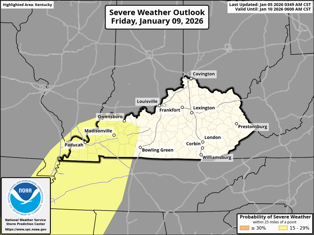
The peak severe weather potential is Friday, especially Friday afternoon into Friday night. Warm, moist air from the Gulf will be in place. Strong winds aloft will overspread the region. Lower Ohio Valley (including KY) is favored for the best setup Forecast guidance continues to trend upward, with a 15% severe risk highlighted where confidence is higher despite some remaining uncertainty in storm timing and strength. Main threat: Damaging winds Secondary/conditional threat: Isolated tornadoes Friday is the day to stay weather-aware in Kentucky. More clarity as we get closer.
-
1. Heavy Rain & Flooding Risk (High Confidence) The Climate Prediction Center has officially highlighted Kentucky in a "Slight Risk of Heavy Precipitation" for January 8–12. Rainfall Totals: There is currently a 30–40% chance that precipitation will exceed 1 inch during this window. The Setup: A (low pressure in the West, high pressure in the East) will pump deep Gulf moisture into the Ohio Valley. Impact: Because this follows a period of snow and cold in early January, the ground may be saturated or frozen, increasing the risk of runoff and localized flooding even with moderate rainfall totals. 2. Severe Weather Potential (Moderate Confidence) While it is too early for the Storm Prediction Center (SPC) to issue a specific "Category 1-5" severe risk, the ingredients for severe winter weather are aligning: The "Fuel": The surge of temperatures into the low 60s provides the instability (CAPE) needed for thunderstorms. The "Trigger": The developing low-pressure system in the Central Mississippi Valley will likely push a strong cold front toward Kentucky. The Threat: In January, severe setups often manifest as a high-shear, low-CAPE environment. This typically favors damaging straight-line winds and fast-moving "QLECS" (lines of storms) rather than isolated supercells. Tornado Risk: While low, these "January Thaws" are historically the most common time for Kentucky to see brief, spin-up tornadoes along the leading edge of a cold front. ________________________________________ Hazard Summary: Jan 8 – Jan 12, 2026 Hazard Risk Level Details Heavy Rain: Slight/Moderate 1.0" to 2.0" possible; flood watches may be needed. Severe Wind: Monitoring for potential 50+ mph gusts within thunderstorms. Tornadoes Low Non-zero; depends on the exact track of the surface low. Snow/Ice Very low temperatures will be far too warm during this peak window.
-
I was in a small quake when I was young in St. Louis. Nothing major, but it is unsettling to have the ground move and there's nothing you can do.
-
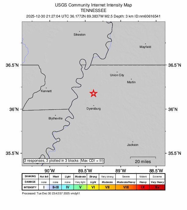
This one was close to the New Madrid Fault.
-
No damage has been reported, but a magnitude 3.1 earthquake was reported in Newbern-Dyer County at 3:40 a.m. today. Newbern is about 10 miles east of Dyersburg. In the past 24 hours, Tennessee had 1 quake of magnitude 3.1 and 2 quakes between 2.0 and 3.0. There were also 2 quakes below magnitude 2.0, which people don’t normally feel. https://talknwesttn.com/earthquake-registering-3-1-reported-in-newbern-today/
-
For Kentucky, the January 6–8 period is shaping up as a high-variability window consistent with a weak La Niña winter pattern. The overall threat level is moderate, not because of a major snowstorm, but due to a high-impact transition from extreme cold to heavy moisture. From January 2–5, a significant cold snap is expected with lows in the 10s to upper teens. This prolonged cold will deepen the frost line in road surfaces. Even as air temperatures rise early next week, pavement temperatures will lag behind, remaining frozen longer than expected. On Tuesday morning, January 6, Gulf moisture will overspread the region while cold air is still retreating. This setup supports a 3- to 6-hour window of freezing rain or sleet, especially across central Kentucky, including Louisville, Lexington, and Richmond. The greatest impacts are expected during the morning commute, with bridges and overpasses becoming slick first. By Wednesday into Thursday, January 7–8, warmer air should fully take over, with temperatures climbing into the 40s and low 50s. The primary concern then shifts to heavy rainfall falling on frozen or saturated ground. Limited infiltration will lead to increased runoff, ponding on roadways, and localized flooding issues. This pattern reflects a classic weak La Niña signal, with frequent intrusions of cold air from Canada colliding with surges of warm, moist Gulf air. Kentucky often ends up near this boundary, resulting in messy ice-to-rain transitions rather than clean winter storms. Kentuckians should not be misled by rising air temperatures. The highest risks are slick, frozen pavement during the Tuesday morning transition and runoff-related impacts later in the week as heavy rain overspreads partially frozen ground. I'll provide an update sometime on Thursday. This is just a preliminary outlook.
-
The Forecast: A Cold Front is Coming Today (Sunday): We are seeing unseasonably warm temperatures (highs in the 60s) with rain showers likely throughout the afternoon. Tonight: A sharp cold front moves through. Temperatures will plummet from the 60s down into the teens and low 20s. Monday (Dec 29): Expect a "shock to the system." Highs will struggle to reach the mid-20s, and gusty northwest winds will make it feel much colder. Any lingering moisture could result in a brief period of flurries, though significant accumulation is not currently expected for most of the state. Key Highlights for BGP Fans Travel: If you are traveling for post-Christmas basketball tournaments or holiday visits, watch out for "flash freeze" conditions tonight as wet roads meet sub-freezing air. Wind: Gusts of 25–35 mph are possible on Monday, creating wind chills in the single digits in some areas. Mid-Week: The bone-chilling cold remains through Tuesday, with a slow warming trend beginning Wednesday as we head toward New Year’s Eve.
-
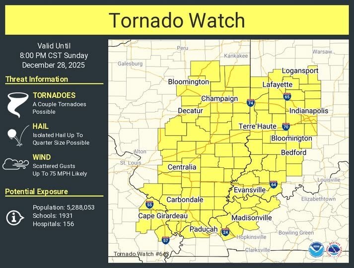
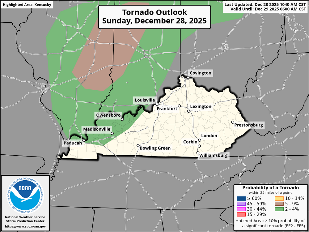
URGENT - IMMEDIATE BROADCAST REQUESTED Tornado Watch Number 643 NWS Storm Prediction Center Norman OK 345 PM EST Sun Dec 28 2025 The NWS Storm Prediction Center has issued a * Tornado Watch for portions of Southern and Central Illinois Western and Central Indiana Western Kentucky Far Southeast Missouri * Effective this Sunday afternoon and evening from 345 PM until 900 PM EST. * Primary threats include... A couple tornadoes possible Scattered damaging winds likely with isolated significant gusts to 75 mph possible SUMMARY...A broken line of thunderstorms will move quickly east-northeastward this afternoon and evening while posing a threat for scattered severe/damaging winds up to 65-75 mph and a couple of tornadoes. The tornado watch area is approximately along and 80 statute miles east and west of a line from 40 miles north northwest of Lafayette IN to 5 miles southeast of Paducah KY. For a complete depiction of the watch see the associated watch outline update (WOUS64 KWNS WOU3). PRECAUTIONARY/PREPAREDNESS ACTIONS... REMEMBER...A Tornado Watch means conditions are favorable for tornadoes and severe thunderstorms in and close to the watch area. Persons in these areas should be on the lookout for threatening weather conditions and listen for later statements and possible warnings.
-
We also have the Kentucky River Fault Zone. The New Madrid Fault Zone is more dangerous than the San Andreas Fault. New Madrid fault Seismic zone The New Madrid Seismic Zone (NMSZ) is one of the most significant earthquake-prone regions in the central United States. Overview The NMSZ is a network of faults located beneath the Mississippi River Valley, primarily affecting southeastern Missouri, northeastern Arkansas, western Tennessee, western Kentucky, and southern Illinois. It is an intraplate fault system, meaning it lies within the interior of the North American tectonic plate rather than along a plate boundary (unlike California’s San Andreas Fault). Historical Earthquakes The zone is best known for the 1811–1812 New Madrid earthquake sequence, which included at least three major earthquakes estimated at magnitude 7.0–7.7. These quakes were felt across much of the eastern U.S., caused ground liquefaction, altered the course of the Mississippi River in places, and created features like Reelfoot Lake in Tennessee. Current Seismic Activity The NMSZ remains seismically active, producing hundreds of small earthquakes each year, most too weak to be felt. Larger damaging earthquakes are infrequent, but the risk is considered real due to the region’s geologic structure. Why It’s Dangerous Central U.S. Compared to similar-magnitude earthquakes in the western United States, earthquakes here can be felt over a much wider area due to the efficient transmission of seismic waves caused by the geology. Much of the region has older buildings and infrastructure not designed for strong earthquakes, increasing potential damage. Risk Outlook USGS estimates suggest roughly a 7–10% chance of a magnitude 7 or greater earthquake in the next 50 years and a higher chance for a magnitude 6+ event. States in and around the zone incorporate the NMSZ into building codes, emergency planning, and preparedness efforts. The U.S. Geological Survey is conducting low-level flights across sections of Missouri, Arkansas and Tennessee this week looking for clues about the New Madrid earthquake fault zone. The USGS begins conducting the flights Wednesday over a 1,400-square-mile area across southeastern Missouri, northeastern Arkansas and western Tennessee. Crews will be measuring the magnetic field of the earth and underground rock formations to help locate concealed faults associated with the New Madrid seismic zone. The USGS says the New Madrid area has been the most seismically active region in the United States east of the Rockies for decades. The USGS says while there's no evidence of an imminent large earthquake, the agency has serious concerns about the potential repeat of a destructive earthquake like those that occurred in the 1800s.
.thumb.webp.23fef33d07794559a098cb6a7b0deb2f.webp)
-
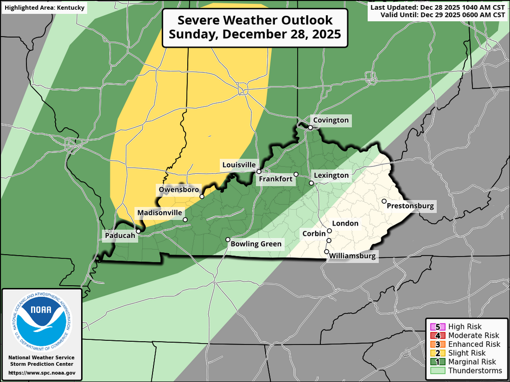
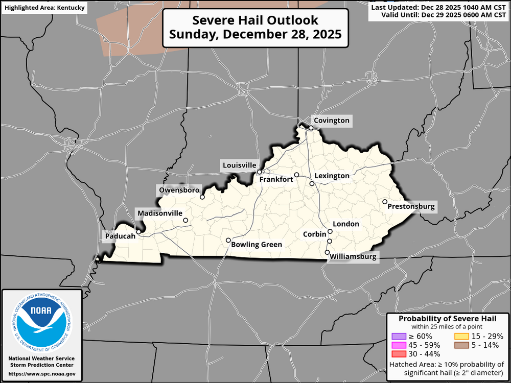
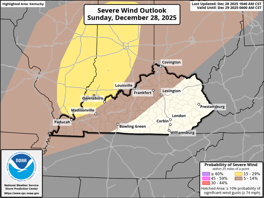
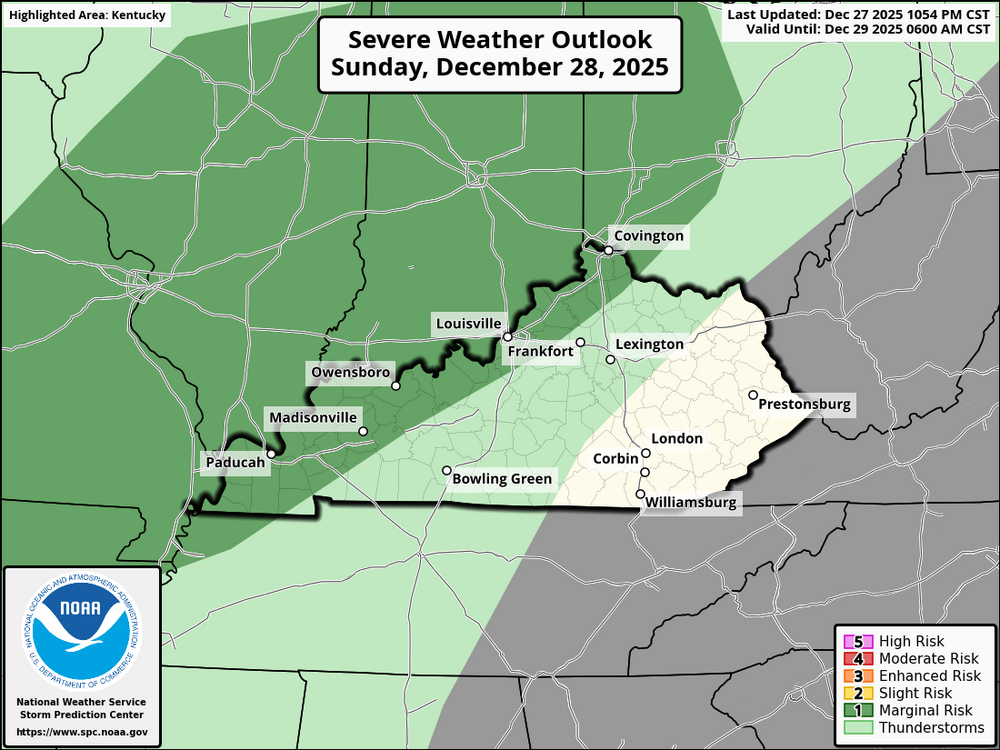
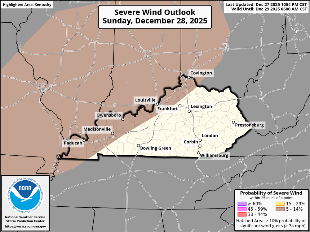
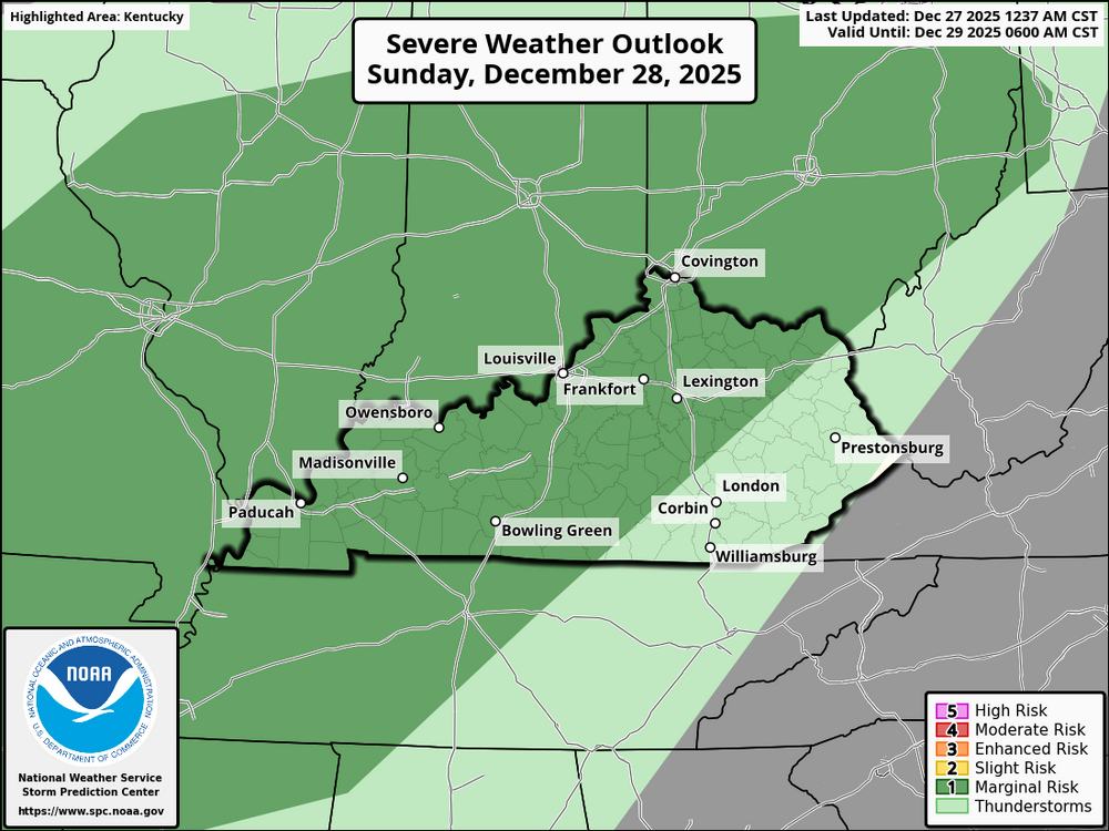
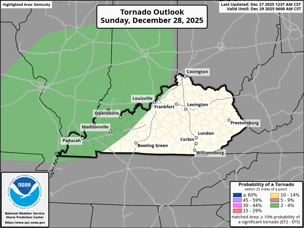
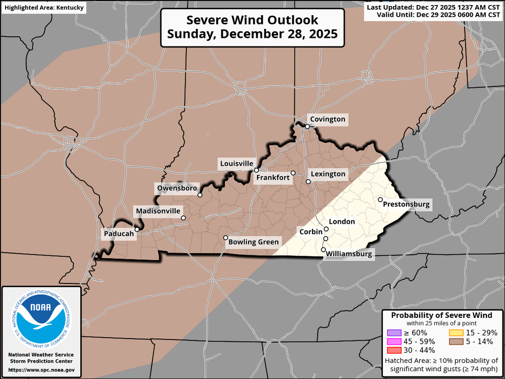
A cold front will sweep across Kentucky today, bringing a risk of strong to severe thunderstorms. Limited instability (500–1000 J/kg of MLCAPE) is expected ahead of the front, but very strong wind shear could allow storms to organize. Western KY (2–6 PM): • Strong storms possible • Damaging wind gusts likely • A few tornadoes possible Eastern KY (6–10 PM): • Storms arrive later in the evening • Mainly damaging winds • Isolated tornadoes possible As the front moves through, storms are expected to line out, producing scattered severe winds and occasional brief tornadoes. A low-end severe threat may continue overnight. Stay alert and monitor local warnings.
-
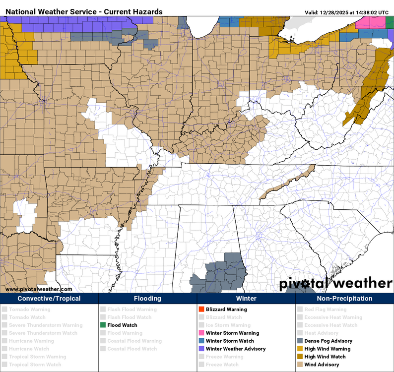
A Wind Advisory is in effect for most of Kentucky, excluding eastern Kentucky, from this evening through Monday. West winds of 15 to 25 mph with gusts of 40 to 45 mph are expected, with a brief window this evening where a fast-moving line of showers could produce isolated wind gusts over 50 mph. Gusty winds may blow around unsecured objects, down tree limbs, and result in a few power outages. Travel may be difficult at times, especially for high-profile vehicles. Secure loose outdoor items and use extra caution if traveling.
-
Kentucky is about to experience "weather whiplash." We are moving from record-breaking warmth today into a high-wind event overnight. Here is the breakdown: THE SETUP Temperatures will soar into the low 70s today—enjoy it, but be ready for it to end abruptly. Even without rain, it will be very windy this afternoon with gusts between 30 and 40 mph. Secure your patio furniture and trash cans. THE OVERNIGHT THREAT A powerful cold front will sweep across the state from west to east tonight. TIMING: Western KY (6pm–10pm), Central KY (10pm–2am), Eastern KY (2am–6am). THE LINE: A thin line of intense storms will move through. The main concern is damaging straight-line winds (60+ mph). SPIN-UPS: While the tornado risk is low, the wind environment is strong enough that a brief "spin-up" tornado along the line cannot be ruled out. Have a way to receive alerts while you sleep! THE MONDAY MORNING CRASH Behind this front, temperatures will plummet 40 degrees in just a few hours. FLASH FREEZE: Any standing water on roads may freeze into black ice before the Monday morning commute. WAKE UP: You’ll be walking out the door to temperatures in the 20s and 30s tomorrow morning. Stay weather-aware, keep your phones charged, and make sure your weather radio is on!
-
For Kentucky and the Ohio Valley, an active weather pattern is expected to continue into early January. From January 1 to 5, temperatures are favored to average below normal, with multiple weather systems bringing above-normal precipitation to the region. Periods of rain are likely, with occasional wintry precipitation possible, especially during overnight hours or behind cold fronts. From January 3–9, the pattern becomes less amplified, allowing temperatures to trend closer to seasonal normals, though unsettled conditions persist with continued chances for precipitation. Overall, early January appears cooler and wetter than normal, with the greatest winter weather risk early in the period across Kentucky and the Ohio Valley.A strong cold front will race through the region Sunday night, bringing a fast-moving line of showers and storms accompanied by strong, gusty winds. Wind gusts of 40+ mph are likely, with localized severe gusts up to 60+ mph possible. The line will move through quickly, lasting only a short time at any one location, but may still produce localized damaging winds. Timing: 7 PM Sunday – 3 AM EST Monday Residents should be prepared for sudden strong wind gusts, which may down tree limbs, cause isolated power outages, and make travel difficult—especially for high-profile vehicles. Secure loose outdoor objects and remain weather-aware through the overnight hours.

.png.0f0aaf6ef979c8734a8e0fb253dabe6b.png)
.png.d12fb7b3e623aed71c6a4ebfc8048de6.png)



.webp.05fa9e3bf8d802c3bd46da07f4977399.webp)


