

nWo
BGP Meteorologist
-
Joined
-
Last visited
Everything posted by nWo
-
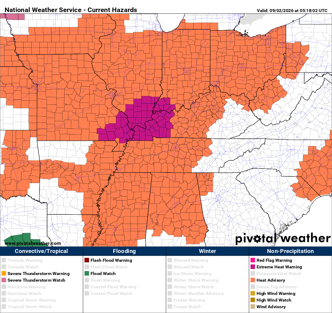
The biggest weather story will be the heat heading into the evening. Afternoon temperatures will climb into the mid and upper 90s, and it will still be very warm when teams take the field. HEAT ALERTS EXTREME HEAT WARNING: Parts of Western Kentucky HEAT ADVISORIES: Portions of Western Kentucky Even outside of official heat alerts, the combination of high temperatures and humidity will make Friday afternoon and early evening uncomfortable. Players, coaches, band members, and fans should take extra precautions during practices, warmups, and pregame activities. WESTERN KENTUCKY Western Kentucky will experience some of the hottest weather in the state, with temperatures climbing into the upper 90s and possibly approaching 100 degrees. Temperatures will slowly fall after sunset, but kickoff temperatures will likely remain in the 80s. Football Forecast: Very hot early, remaining warm and humid throughout the game. CENTRAL KENTUCKY Another hot day is expected across Central Kentucky, with afternoon temperatures reaching the mid to upper 90s. By kickoff, temperatures should still be in the mid to upper 80s, gradually falling later in the evening. An isolated shower or thunderstorm is possible, but most games should remain dry. Football Forecast: Hot and humid at kickoff, gradually becoming more comfortable. LOUISVILLE AREA Expect another very hot afternoon, with temperatures climbing into the upper 90s. Friday night games will begin warm and humid, with temperatures remaining in the 80s for much of the evening. Football Forecast: Very warm start with slow improvement after sunset. SOUTH-CENTRAL KENTUCKY Bowling Green and surrounding areas The heat will remain intense Friday afternoon, with temperatures climbing well into the 90s. Kickoff temperatures should still be in the mid to upper 80s, making the first half especially warm and uncomfortable. EASTERN KENTUCKY Eastern Kentucky will also be warm and humid, although temperatures should be slightly lower than locations farther west. Expect temperatures in the 80s at kickoff, falling into the 70s later in the evening. NORTHERN KENTUCKY / CINCINNATI Northern Kentucky and the Cincinnati area will see a warm and humid start to Friday night football. Temperatures should be in the 80s around kickoff before slowly falling later in the evening. Most games should stay dry.
-
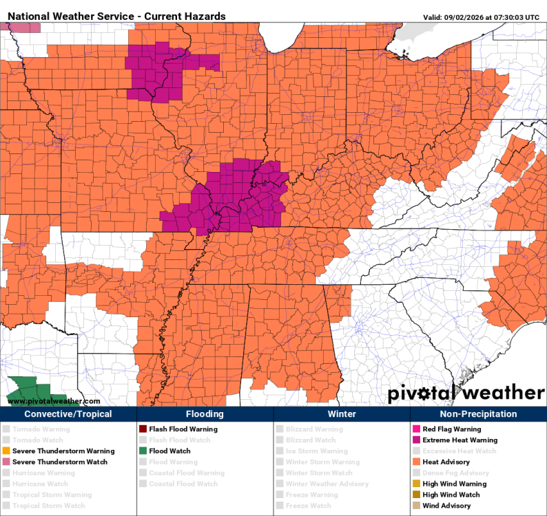
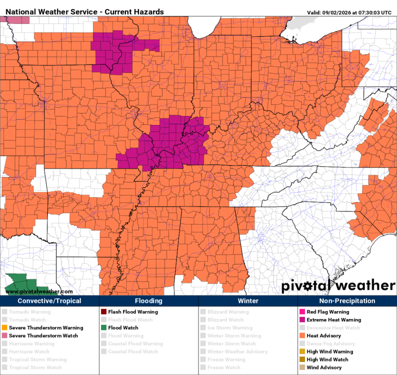
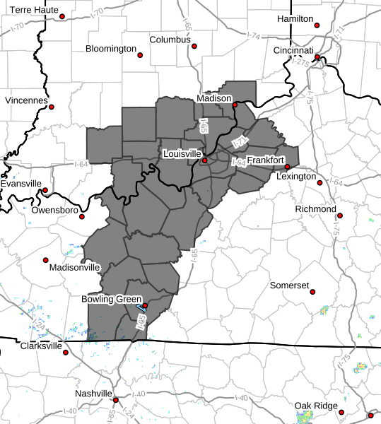
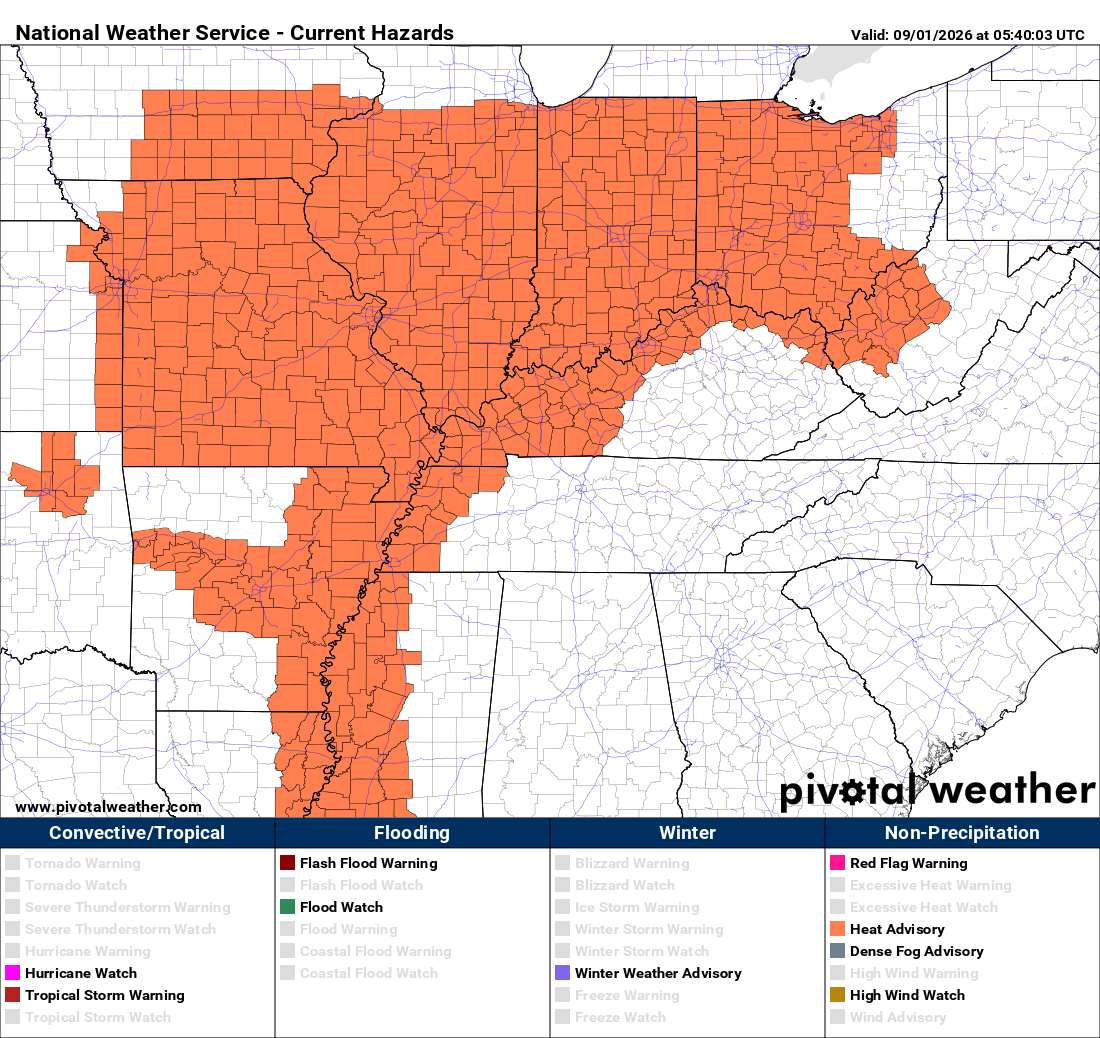
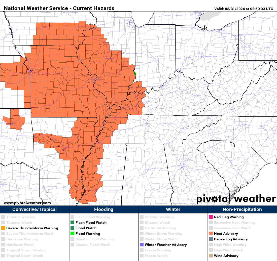
The heat advisory area has been expanded URGENT - WEATHER MESSAGE National Weather Service Louisville KY 220 AM EDT Wed Sep 2 2026 INZ076>079-083-084-089>092-KYZ023>043-045>049-053>057-061>067- 070>078-081-082-022000- /O.EXT.KLMK.HT.Y.0010.000000T0000Z-260905T0000Z/ Orange-Washington IN-Scott IN-Jefferson IN-Dubois-Crawford-Perry- Harrison IN-Floyd-Clark IN-Hancock-Breckinridge-Meade-Ohio- Grayson-Hardin-Bullitt-Jefferson-Oldham-Trimble-Henry-Shelby- Franklin-Scott KY-Harrison KY-Spencer-Anderson-Woodford-Fayette- Bourbon-Nicholas-Nelson-Washington KY-Mercer-Jessamine-Clark KY- Larue-Marion-Boyle-Garrard-Madison-Butler-Edmonson-Hart-Green-Taylor- Casey-Lincoln-Logan-Warren-Simpson-Allen-Barren-Monroe-Metcalfe- Adair-Russell-Cumberland-Clinton- Including the cities of Taylorsville, Corydon, Brownsville, Elizabethtown, Springfield, Scottsburg, Scottsville, Franklin, Tell City, Shepherdsville, Frankfort, Cynthiana, Russellville, Tompkinsville, Burkesville, English, New Castle, Jamestown, Edmonton, Columbia, Paoli, Horse Cave, Leitchfield, Albany, La Grange, Liberty, Versailles, Greensburg, Harrodsburg, Brandenburg, Jasper, Morgantown, Campbellsville, Milton, Lawrenceburg, Louisville, Lewisport, Paris, Hartford, Lancaster, Jeffersonville, Bedford, Lebanon, Hodgenville, Glasgow, Georgetown, Salem, Lexington, Providence, Bardstown, Nicholasville, Danville, Richmond, Stanford, Bowling Green, Shelbyville, Hawesville, New Albany, Carlisle, Winchester, Hardinsburg, and Madison 220 AM EDT Wed Sep 2 2026 /120 AM CDT Wed Sep 2 2026/ ...HEAT ADVISORY NOW IN EFFECT UNTIL 8 PM EDT /7 PM CDT/ FRIDAY... * WHAT...Heat index values between 100 and 107 for at least three successive days. Limited nighttime relief as low temperatures are only expected to fall into the low-to-mid 70s. * WHERE...Portions of south central Indiana and north central, northwest, and south central Kentucky. * WHEN...Until 8 PM EDT /7 PM CDT/ Friday. * IMPACTS...Prolonged hot temperatures and high humidity may cause heat illnesses. PRECAUTIONARY/PREPAREDNESS ACTIONS... Drink plenty of fluids, stay in an air-conditioned room, stay out of the sun, and check up on relatives and neighbors. To reduce risk during outdoor work, the Occupational Safety and Health Administration recommends scheduling frequent rest breaks in shaded or air conditioned environments. Anyone overcome by heat should be moved to a cool and shaded location. Heat stroke is an emergency! Call 9 1 1.
-
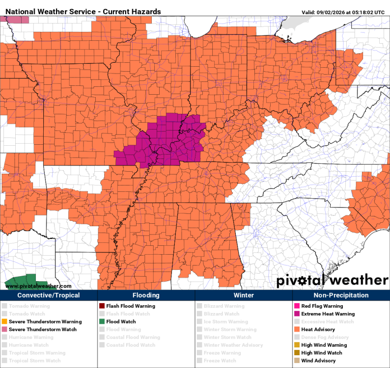
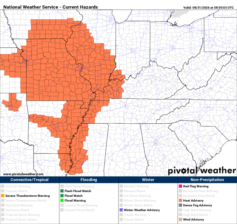
URGENT - WEATHER MESSAGE National Weather Service Paducah KY 1146 AM CDT Tue Sep 1 2026 ILZ075>078-080>094-INZ081-082-085>088-KYZ001>022-MOZ076-086-087-100- 107>112-114-021100- /O.UPG.KPAH.HT.Y.0009.000000T0000Z-260905T0100Z/ /O.NEW.KPAH.XH.W.0006.260901T1646Z-260906T0100Z/ Jefferson-Wayne IL-Edwards-Wabash-Perry IL-Franklin-Hamilton- White-Jackson-Williamson-Saline-Gallatin-Union-Johnson-Pope-Hardin- Alexander-Pulaski-Massac-Gibson-Pike-Posey-Vanderburgh-Warrick- Spencer-Fulton-Hickman-Carlisle-Ballard-McCracken-Graves-Livingston- Marshall-Calloway-Crittenden-Lyon-Trigg-Caldwell-Union KY-Webster- Hopkins-Christian-Henderson-Daviess-McLean-Muhlenberg-Todd-Perry MO- Bollinger-Cape Girardeau-Wayne MO-Carter-Ripley-Butler-Stoddard- Scott-Mississippi-New Madrid- Including the cities of Harrisburg, Poseyville, Hopkinsville, Eddyville, Cape Girardeau, Smithland, Benton, Calhoun, Poplar Bluff, Cadiz, Paducah, Piedmont, Carbondale, Carmi, Bloomfield, Marion, Herrin, Murray, Mound City, Van Buren, Jonesboro, Metropolis, Morganfield, Fairfield, Wickliffe, Fort Branch, Marble Hill, McLeansboro, Golconda, Henderson, Charleston, West Frankfort, Shawneetown, Bardwell, New Madrid, Mayfield, Rockport, Cairo, Jackson, Albion, Princeton, Petersburg, Greenville, Elkton, Murphysboro, Mount Vernon, Madisonville, Perryville, Hickman, Doniphan, Dixon, Mount Carmel, Elizabethtown, Evansville, Clinton, Pinckneyville, Owensboro, Sikeston, Vienna, and Boonville 1146 AM CDT Tue Sep 1 2026 /1246 PM EDT Tue Sep 1 2026/ ...EXTREME HEAT WARNING IN EFFECT UNTIL 8 PM CDT /9 PM EDT/ SATURDAY... * WHAT...Dangerously hot conditions with peak daily heat index values 103 to 109 degrees; actual maximum air temperatures will range from 95 to 101 degrees daily! * WHERE...All of southern Illinois, southwest Indiana, western Kentucky, and southeast Missouri. * WHEN...Until 8 PM CDT /9 PM EDT/ Saturday. * IMPACTS...Heat related illnesses increase significantly during extreme heat and high humidity events. * ADDITIONAL DETAILS...This week of extreme and dangerous heat shows no signs of abating. Climatologically extreme high forecast temperatures a good 10 to 15 degrees above their seasonal normals will combine with the effects of humidity to increasingly make this week a dangerous period of prolonged heat. Heat index values hit triple digits every day and may top out up to 109 degrees. Actual air temperatures reach to near or even above 100 degrees multiple days in a row. Numerous nights might have warm record overnight low temperatures in the mid 70s as well, so there is really no significant break offered from the heat as we head into the holiday weekend and all the numerous activities and outdoor events that may be planned. PRECAUTIONARY/PREPAREDNESS ACTIONS... Drink plenty of fluids, stay in an air-conditioned room, stay out of the sun, and check up on relatives and neighbors. Take extra precautions when outside. Wear lightweight and loose fitting clothing. Try to limit strenuous activities to early morning or evening. Take action when you see symptoms of heat exhaustion and heat stroke.
-
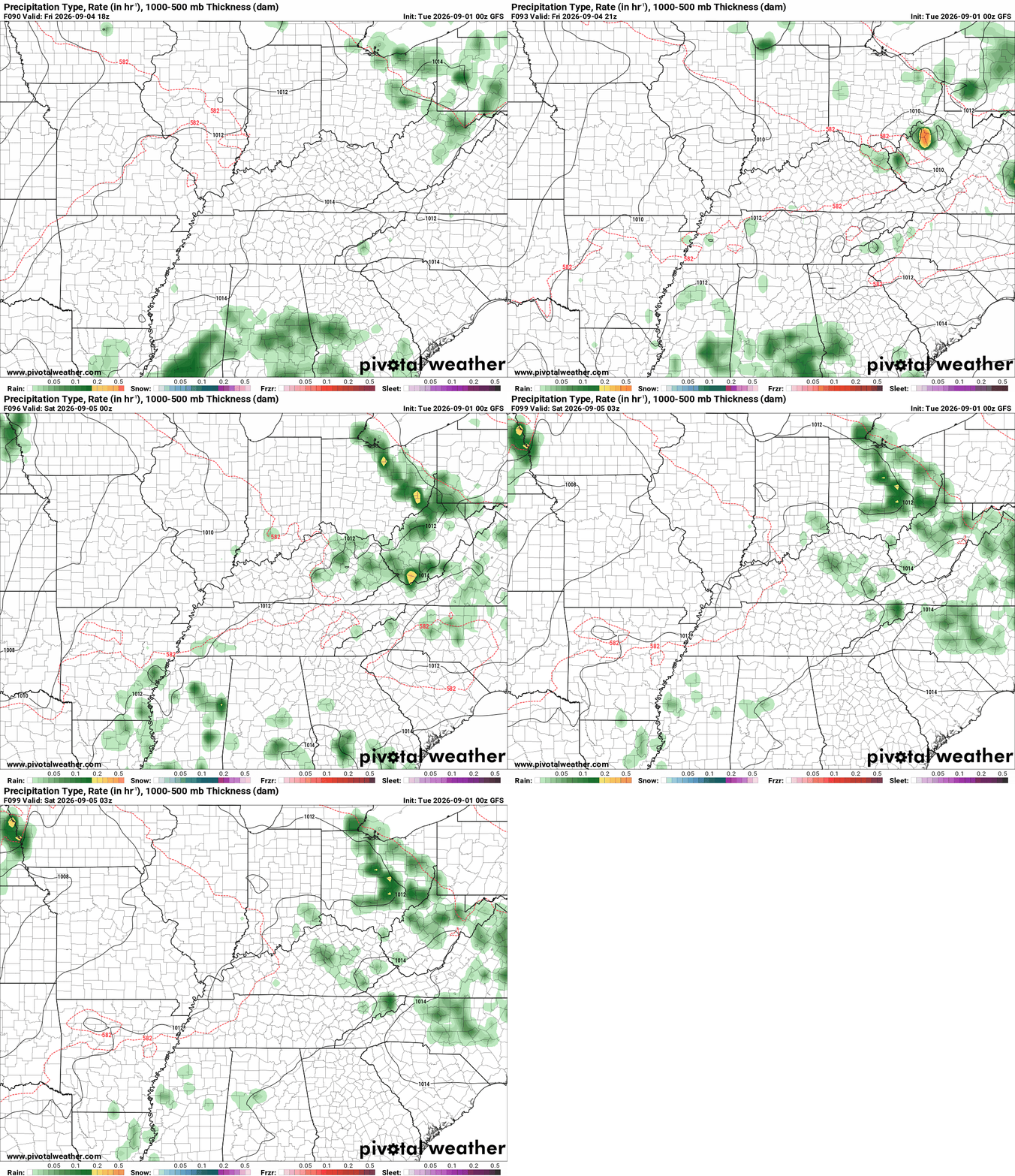
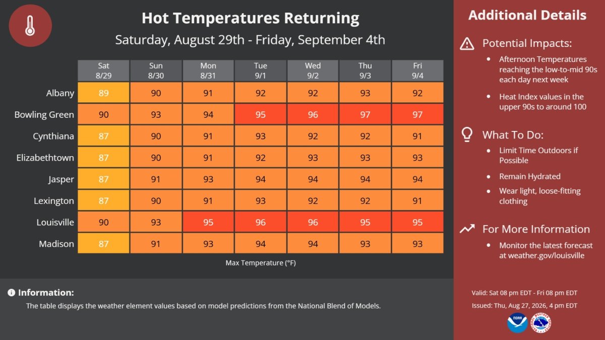
Friday night football across Kentucky is looking warm and humid, but overall the weather should be fairly cooperative for most games. A weak weather system is expected to bring showers to parts of the state earlier in the day, especially across eastern Kentucky. Conditions should gradually improve from west to east during the afternoon and evening, although eastern Kentucky could hold onto clouds and showers longer. Western Kentucky: Expect the best football weather by Friday evening. Any morning rain should be long gone, leaving a warm and humid night with temperatures generally in the 80s at kickoff and slowly falling later in the game. Central Kentucky: A warm and humid evening is expected. Skies should be improving by kickoff, with temperatures mainly in the low to mid-80s. Most games should be dry, although a lingering shower cannot be completely ruled out. Louisville: Look for improving conditions Friday evening after any earlier showers. Temperatures should be in the mid-80s around kickoff and remain warm through much of the game. Lexington/Richmond: Friday could begin with showers and plenty of humidity, but conditions are expected to improve later in the day. Temperatures should be in the lower 80s around kickoff, with a small chance that a lingering shower could still affect the game. Northern Kentucky/Cincinnati: Expect a warm and humid night under mostly cloudy to partly cloudy skies. Temperatures should be in the lower to mid-80s at kickoff and fall into the 70s later in the evening. Eastern Kentucky: This will be the area to watch most closely. Showers could linger longer into the day and possibly into the evening in some locations. Temperatures should generally be in the upper 70s to lower 80s around kickoff. Statewide rain chance: Around 20-30% during the Friday evening football hours, with the highest chances across eastern Kentucky.URGENT - WEATHER MESSAGE National Weather Service Wilmington OH 133 AM EDT Tue Sep 1 2026 INZ050-058-059-066-073>075-080-KYZ089>100-OHZ026-034-035-042>046- 051>056-060>065-070>074-077>082-088-011400- /O.EXT.KILN.HT.Y.0006.260901T1800Z-260904T0000Z/ Wayne-Fayette-Union-Franklin-Ripley-Dearborn-Ohio-Switzerland- Carroll-Gallatin-Boone-Kenton-Campbell-Owen-Grant-Pendleton-Bracken- Robertson-Mason-Lewis-Hardin-Mercer-Auglaize-Darke-Shelby-Logan- Union-Delaware-Miami-Champaign-Clark-Madison-Franklin-Licking-Preble- Montgomery-Greene-Fayette-Pickaway-Fairfield-Butler-Warren-Clinton- Ross-Hocking-Hamilton-Clermont-Brown-Highland-Adams-Pike-Scioto- Including the cities of Dayton, Xenia, Portsmouth, Liberty, Fairfield, Mount Carmel, Camp Dix, Newark, Downtown Columbus, Mason, Delaware, Piketon, Independence, Dillsboro, Burlington, Marysville, Day Heights, Osgood, Summerside, Hillsboro, Minster, Downtown Cincinnati, Peebles, Washington Court House, Oxford, Head Of Grassy, Landen, Greendale, Ripley, Mulberry, Lawrenceburg, Covington, Warsaw, Aberdeen, Greenfield, Bright, Chillicothe, Bellefontaine, Highland Heights, Bellevue, Greenville, Carrollton, Mount Olivet, Milan, Brookville, Blanchester, Connersville, Pike Lake, London, Versailles, Owenton, Ada, West College Corner, Rising Sun, Fairborn, Erlanger, Pickerington, Wapakoneta, Withamsville, Plain City, Circleville, Celina, Troy, Maysville, Middletown, Hidden Valley, Butler, Piqua, Tollesboro, St. Marys, Lebanon, Newport, Dry Ridge, Fort Thomas, Kettering, Richmond, Hamilton, Downtown Dayton, Logan, Oakbrook, Waverly, Beavercreek, Williamstown, New Bremen, Camden, Springboro, Milford, Aurora, Manchester, Vevay, Wilmington, Seaman, West Jefferson, Eaton, Tipp City, Winchester, Lancaster, Wheelersburg, Alexandria, Augusta, Sidney, Coldwater, Falmouth, Franklin, Brooksville, Batesville, Crittenden, West Union, Mount Repose, Mount Orab, Kenton, Florence, Vanceburg, Springfield, Urbana, and Georgetown 133 AM EDT Tue Sep 1 2026 ...HEAT ADVISORY NOW IN EFFECT FROM 2 PM THIS AFTERNOON TO 8 PM EDT THURSDAY... * WHAT...Heat index values up to 104 expected. * WHERE...Portions of east central and southeast Indiana, northeast and northern Kentucky, and central, south central, southwest, and west central Ohio. * WHEN...From 2 PM this afternoon to 8 PM EDT Thursday. * IMPACTS...Hot temperatures and high humidity may cause heat illnesses. PRECAUTIONARY/PREPAREDNESS ACTIONS... Drink plenty of fluids, stay in an air-conditioned room, stay out of the sun, and check up on relatives and neighbors. Take extra precautions when outside. Wear lightweight and loose fitting clothing. Try to limit strenuous activities to early morning or evening. Take action when you see symptoms of heat exhaustion and heat stroke.URGENT - WEATHER MESSAGE National Weather Service Louisville KY 849 PM EDT Mon Aug 31 2026 INZ076>079-083-084-089>092-KYZ023>035-038-061-062-070>072-010900- /O.CON.KLMK.HT.Y.0010.260901T1700Z-260904T0000Z/ Orange-Washington IN-Scott IN-Jefferson IN-Dubois-Crawford-Perry- Harrison IN-Floyd-Clark IN-Hancock-Breckinridge-Meade-Ohio- Grayson-Hardin-Bullitt-Jefferson-Oldham-Trimble-Henry-Shelby- Franklin-Spencer-Butler-Edmonson-Logan-Warren-Simpson- Including the cities of Jeffersonville, Providence, Shepherdsville, English, Tell City, La Grange, New Castle, Russellville, Paoli, Shelbyville, Morgantown, Milton, Lewisport, Franklin, Salem, Jasper, Bowling Green, Scottsburg, Madison, Leitchfield, Bedford, Hartford, Hardinsburg, Frankfort, Taylorsville, Hawesville, Brownsville, New Albany, Corydon, Brandenburg, Elizabethtown, and Louisville 849 PM EDT Mon Aug 31 2026 /749 PM CDT Mon Aug 31 2026/ ...HEAT ADVISORY REMAINS IN EFFECT FROM 1 PM EDT /NOON CDT/ TUESDAY TO 8 PM EDT /7 PM CDT/ THURSDAY... * WHAT...Heat index values between 100 and 107 for at least three successive days. Limited nighttime relief as low temperatures are only expected to fall into the low-to-mid 70s. * WHERE...Portions of south central Indiana and north central, northwest, and south central Kentucky. * WHEN...From 1 PM EDT /noon CDT/ Tuesday to 8 PM EDT /7 PM CDT/ Thursday. * IMPACTS...Prolonged hot temperatures and high humidity may cause heat illnesses. PRECAUTIONARY/PREPAREDNESS ACTIONS... Drink plenty of fluids, stay in an air-conditioned room, stay out of the sun, and check up on relatives and neighbors.
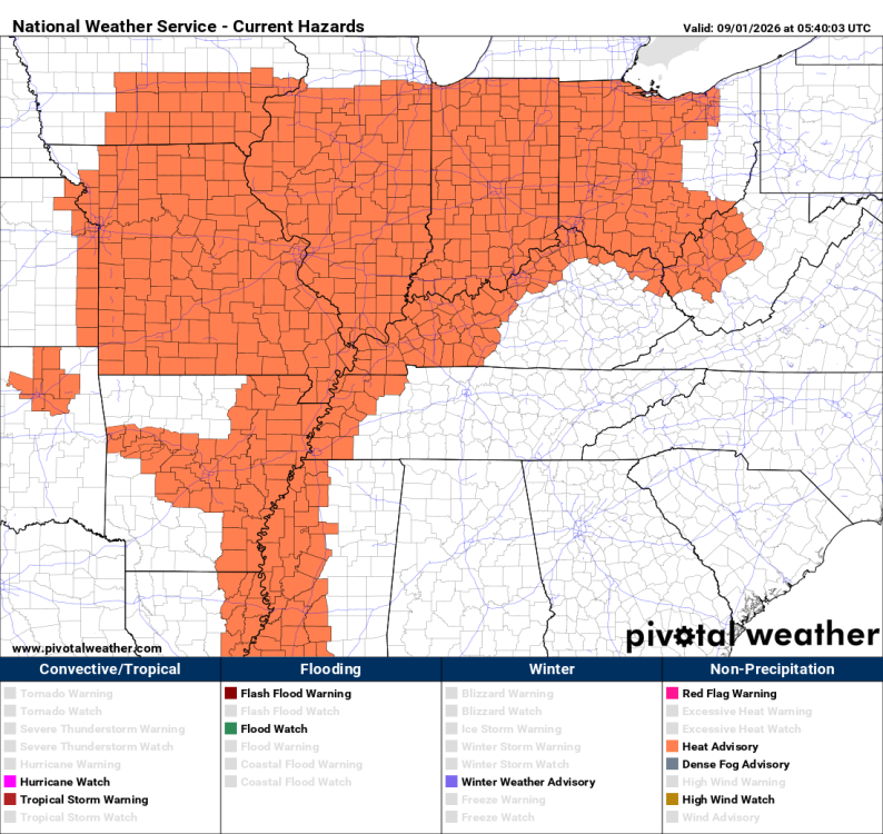 INZ076>079-083-084-089>092-KYZ023>035-038-061-062-070>072-010115- /O.NEW.KLMK.HT.Y.0010.260901T1700Z-260904T0000Z/ Orange-Washington IN-Scott IN-Jefferson IN-Dubois-Crawford-Perry- Harrison IN-Floyd-Clark IN-Hancock-Breckinridge-Meade-Ohio- Grayson-Hardin-Bullitt-Jefferson-Oldham-Trimble-Henry-Shelby- Franklin-Spencer-Butler-Edmonson-Logan-Warren-Simpson- Including the cities of Hartford, Russellville, Taylorsville, English, New Albany, Elizabethtown, Frankfort, Hardinsburg, New Castle, Shepherdsville, Jasper, Jeffersonville, Louisville, Corydon, Leitchfield, Hawesville, Shelbyville, Scottsburg, La Grange, Bowling Green, Salem, Bedford, Milton, Providence, Franklin, Lewisport, Brownsville, Brandenburg, Tell City, Madison, Morgantown, and Paoli 114 PM EDT Mon Aug 31 2026 /1214 PM CDT Mon Aug 31 2026/ ...HEAT ADVISORY IN EFFECT FROM 1 PM EDT /NOON CDT/ TUESDAY TO 8 PM EDT /7 PM CDT/ THURSDAY... * WHAT...Heat index values near 100 on Tuesday and up to 106 by Thursday expected. * WHERE...Portions of south central Indiana and east central, north central, northwest, and south central Kentucky. * WHEN...From 1 PM EDT /noon CDT/ Tuesday to 8 PM EDT /7 PM CDT/ Thursday. * IMPACTS...Prolonged hot temperatures and high humidity may cause heat illnesses. PRECAUTIONARY/PREPAREDNESS ACTIONS... Drink plenty of fluids, stay in an air-conditioned room, stay out of the sun, and check up on relatives and neighbors.
 URGENT - WEATHER MESSAGE National Weather Service Paducah KY 1048 PM CDT Sun Aug 30 2026 ILZ075>078-080>094-INZ081-082-085>088-KYZ001>022-MOZ076-086-087-100- 107>112-114-312115- /O.CAN.KPAH.XH.A.0002.260901T1500Z-260905T0100Z/ /O.EXT.KPAH.HT.Y.0009.260831T1500Z-260905T0100Z/ Jefferson-Wayne IL-Edwards-Wabash-Perry IL-Franklin-Hamilton- White-Jackson-Williamson-Saline-Gallatin-Union-Johnson-Pope-Hardin- Alexander-Pulaski-Massac-Gibson-Pike-Posey-Vanderburgh-Warrick- Spencer-Fulton-Hickman-Carlisle-Ballard-McCracken-Graves-Livingston- Marshall-Calloway-Crittenden-Lyon-Trigg-Caldwell-Union KY-Webster- Hopkins-Christian-Henderson-Daviess-McLean-Muhlenberg-Todd-Perry MO- Bollinger-Cape Girardeau-Wayne MO-Carter-Ripley-Butler-Stoddard- Scott-Mississippi-New Madrid- Including the cities of Murphysboro, Elizabethtown, Mound City, Poplar Bluff, Hickman, Paducah, Harrisburg, Princeton, Wickliffe, Hopkinsville, Henderson, Fairfield, Piedmont, Perryville, Marion, Metropolis, Poseyville, Cadiz, Fort Branch, Pinckneyville, Jonesboro, Benton, Marble Hill, Cairo, Carbondale, Mount Vernon, Jackson, McLeansboro, Shawneetown, Charleston, West Frankfort, New Madrid, Sikeston, Elkton, Murray, Vienna, Owensboro, Boonville, Carmi, Mayfield, Petersburg, Smithland, Evansville, Greenville, Calhoun, Herrin, Eddyville, Albion, Doniphan, Madisonville, Rockport, Bardwell, Clinton, Bloomfield, Morganfield, Cape Girardeau, Van Buren, Golconda, Mount Carmel, and Dixon 1048 PM CDT Sun Aug 30 2026 /1148 PM EDT Sun Aug 30 2026/ ...EXTREME HEAT WATCH IS CANCELLED... ...HEAT ADVISORY NOW IN EFFECT FROM 10 AM CDT /11 AM EDT/ MONDAY TO 8 PM CDT /9 PM EDT/ FRIDAY... * WHAT...Daily heat index values up to 100-106 expected. * WHERE...Portions of southern Illinois, southwest Indiana, western Kentucky, and southeast Missouri. * WHEN...From 10 AM CDT /11 AM EDT/ Monday to 8 PM CDT /9 PM EDT/ Friday. * IMPACTS...Hot temperatures and high humidity may cause heat illnesses. * ADDITIONAL DETAILS...Heat index values will be closer to 100 on Monday. Low rain chances on Friday may provide limited relief. PRECAUTIONARY/PREPAREDNESS ACTIONS... Drink plenty of fluids, stay in an air-conditioned room, stay out of the sun, and check up on relatives and neighbors.
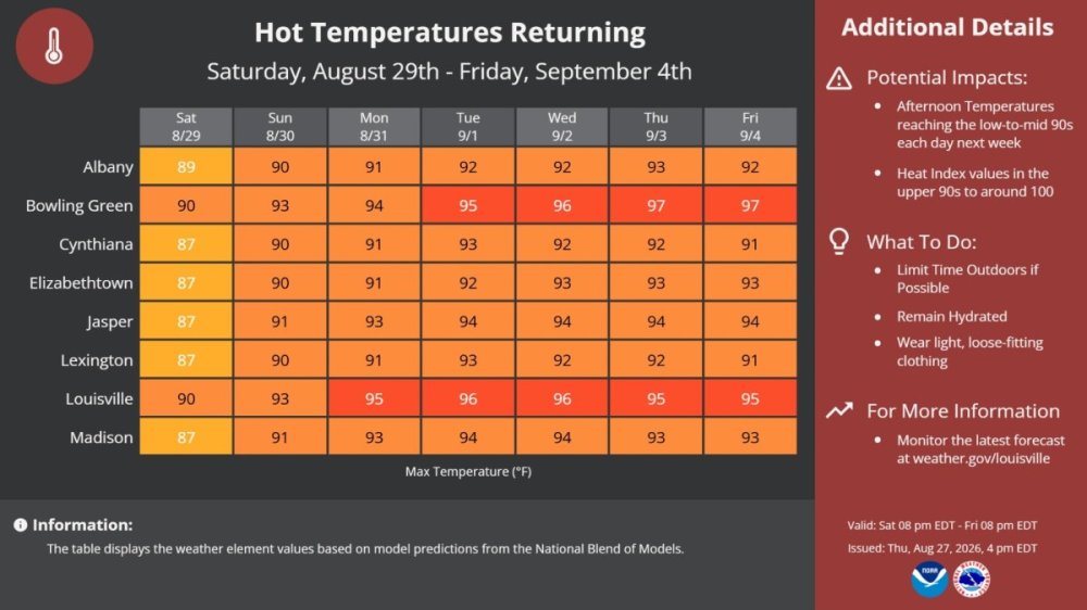
 Friday night looks like another warm and humid night for high school football across Kentucky. Temperatures will still be running well above comfortable football weather at kickoff, especially across western and central parts of the state. Most games should stay dry, but a few showers or thunderstorms could create problems in isolated areas. Western Kentucky: Expect a warm and muggy start, with temperatures in the upper 80s around kickoff. Readings will slowly fall through the 80s during the evening. Most games should stay dry, although an isolated storm cannot be completely ruled out. Central Kentucky: It will be hot and humid heading into kickoff, with temperatures mainly in the mid- to upper 80s. By the fourth quarter, temperatures should begin dropping toward the upper 70s and lower 80s. Rain chances appear low overall, but teams should keep an eye on the sky. Eastern Kentucky: A warm and humid evening is expected, with temperatures generally in the low to mid-80s at kickoff and falling into the 70s later in the game. A few showers or thunderstorms could be around, particularly earlier in the evening. Northern Kentucky/Cincinnati: Expect warm and humid conditions for Friday night football. Temperatures should be in the 80s at kickoff before gradually cooling through the evening. Most locations should have a good night for football, with only a small chance of an isolated shower or thunderstorm. Louisville: Another hot start is expected, with temperatures near the upper 80s at kickoff. It will remain warm well into the evening, with temperatures slowly falling through the 80s. Richmond/Lexington: Expect a warm and humid start to the night, with temperatures in the mid- to upper 80s around kickoff. Conditions should gradually become more comfortable later in the game as temperatures fall toward the upper 70s. The biggest concern will be the heat and humidity during warmups and the first half. Players and fans should stay hydrated and be prepared for another warm September football night.The developing El Niño is becoming a major player heading into winter, and this is shaping up to be a very strong event. For Kentucky, that points toward a winter that is likely to be wetter and milder overall, but that doesn't mean we can forget about snow and ice. The early call is for temperatures to average about 1 to 3 degrees above normal across Kentucky this winter. December could start relatively mild, while January may bring the biggest swings in temperature. February could turn milder again, although winter weather threats will remain possible. Precipitation should run near to or above normal. A strong El Niño typically favors an active storm track across the southern United States and Ohio Valley, which could put Kentucky in the path of several storm systems. The big question will be temperatures when those storms arrive. Western Kentucky may have a difficult time seeing prolonged snow, with more rain and mixed precipitation expected. Central Kentucky could go back and forth between rain, snow, sleet, and freezing rain, depending on the track of each storm. Eastern Kentucky and the higher elevations may have a better opportunity for accumulating snow. Northern Kentucky and the Cincinnati area could also see several opportunities for snow and ice when colder air settles into the Ohio Valley. One or two significant winter storms cannot be ruled out. A strong storm moving through the Ohio Valley at the same time Arctic air is in place could produce a substantial snow or ice event across portions of Kentucky. So, for now, I'm expecting a mild, wet, and active winter rather than a consistently cold winter. Temperature: Above normal Precipitation: Near to above normal Snowfall: Near normal overall Ice: Above-normal potential Major winter storm potential: Higher than normal Coldest period: Most likely January into early February The current El Niño has the potential to become stronger than most of these historical events. That makes the 1982-83, 1997-98, and 2015-16 winters especially useful comparisons.Looks like we've got a pretty good night for high school football across Kentucky. It will still be warm when the games kick off, with most areas starting out in the upper 70s to around 80. Once the sun goes down, temperatures will gradually fall through the 70s, making for a comfortable night under the lights. Most of the state should stay dry, and rain does not look like it will be a problem for Friday night games. Western Kentucky: Mostly clear to partly cloudy skies with temperatures near 80 at kickoff. Expect low to mid-70s by the end of the game. Central Kentucky: A nice night for football. Temperatures will be in the upper 70s to near 80 early and fall into the lower 70s later in the evening. Eastern Kentucky: Warm at kickoff with temperatures mainly in the 70s. Most games should have dry weather and comfortable conditions through the night. Northern Kentucky/Cincinnati: Dry and pleasant for football. Temperatures will start near 80 and fall through the 70s as the evening goes along. Louisville: Warm at kickoff, near 80 degrees, with temperatures dropping into the mid-70s later in the game. Statewide rain chance: Around 10% or lessSummer isn't ready to give up just yet. A hot stretch of weather is shaping up for Kentucky and the Cincinnati area as we head into the first week of September. Afternoon temperatures will push into the 90s across much of the region, with the heat building early in the week. Current forecasts show highs around 90 to the mid-90s in many areas. Western Kentucky: Expect some of the hottest weather in the state. Highs should reach the low to mid 90s, with Paducah, Hopkinsville, and surrounding areas feeling the heat. Central Kentucky: Lexington, Richmond, and the surrounding area will see highs near or above 90 degrees. Monday looks hot, and the heat should continue through the middle of the week. Warm overnight temperatures in the upper 60s and low 70s will provide little relief. Eastern Kentucky: It will be hot here as well, although higher elevations may stay a few degrees cooler. Most areas can expect afternoon highs in the upper 80s to lower 90s. Northern Kentucky & Cincinnati: The heat builds Sunday and continues into next week. Highs are expected to reach the low 90s Monday, with temperatures remaining around 90 to the lower 90s through the middle of the week. Cincinnati forecasts currently support a sustained hot stretch into early September. Louisville: Several hot afternoons are on the way, with temperatures generally in the lower to middle 90s. Nights will stay warm, especially in the city. Forecast details can still change as we get closer to next week.
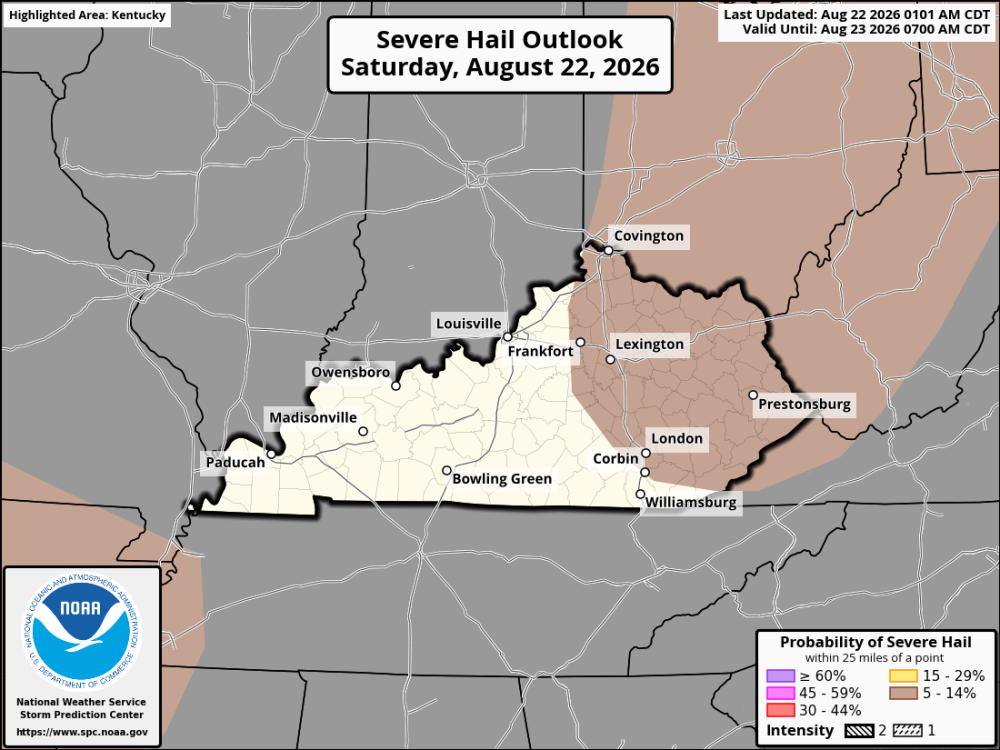
 Looks like Kentucky high school football teams should have very good weather Friday night. Most of the state is expected to stay dry, and while it will still be warm at kickoff, temperatures should ease into the 70s as the night goes along. Western Kentucky: Expect a warm start with temperatures around 80 at kickoff. Skies should be mostly clear to partly cloudy, with temperatures slipping into the mid-70s later in the game. Rain chance around 10%. Central Kentucky: A good night for football. Temperatures will be in the upper 70s to near 80 early, then drop into the low 70s by late evening. Rain chance around 10%. Eastern Kentucky: A few more clouds are possible, and there could be a stray shower somewhere in the region, but most games should stay dry. Temperatures will generally be in the 70s throughout the evening. Rain chance 10 to 15%. Northern Kentucky/Cincinnati: Dry weather is expected for most of the evening. Temperatures will start in the upper 70s and gradually fall through the 70s as the games move along. Rain chance around 10%. Louisville Area: Warm at kickoff with temperatures near 80, then cooling into the low to mid-70s by the end of the game. Rain chance around 10%. Statewide: About a 10% chance of rain during the games. Most of Kentucky should stay dry.I'm from St. Louis, and you had me confused for a second. I was thinking about Trinity High School in St. Louis County. Then I realized you were talking about Trinity High School in Louisville. Friday night looks like a good one for high school football around St. Louis. It will be warm at kickoff with temperatures in the low 80s, but temperatures should gradually fall through the evening. Expect mostly clear skies with dry conditions. Temperatures should drop into the upper 70s by halftime and reach the low to mid-70s by the end of the game. Rain is not expected.Tuesday update: Western Kentucky: Mostly clear to partly cloudy and warm at kickoff. Temperatures near 80 degrees early, falling into the low to mid 70s by the fourth quarter. Central Kentucky: A pleasant night for football with temperatures in the upper 70s to near 80 at kickoff, falling into the lower 70s later in the evening. Eastern Kentucky: Warm and comfortable conditions with temperatures mainly in the 70s. Most games should have favorable weather. Northern Kentucky/Cincinnati: A dry and pleasant evening is expected, with temperatures falling through the 70s during the game. Louisville: Warm at kickoff with temperatures near 80 degrees, falling into the low to mid 70s by the end of the game. Statewide rain chance around 10% Most of Kentucky is expected to stay dry Friday evening. An isolated shower cannot be completely ruled out somewhere across the state, but widespread rain is not expected. The model guidance for the main 6 PM through 10 PM shows little to no precipitation across KentuckyFriday night is looking pretty good for high school football across Kentucky. It will be warm at kickoff, with temperatures mostly in the upper 70s to lower 80s. By the fourth quarter, most areas should be down into the 70s. There is a chance of a shower or thunderstorm in some parts of the state, but it does not look like a washout. Western Kentucky has the best chance to stay dry, while rain chances increase some as you head east. Central Kentucky, including Lexington and Richmond, has around a 15 percent chance of rain. Eastern and southeastern Kentucky may have a better chance of seeing a stray shower or storm. For most teams, the weather should not be a problem. A passing shower or storm could cause an issue at a few games, so keep an eye on the sky, especially before kickoff.A weather system moving through the Great Lakes and Ohio Valley will bring the chance for scattered thunderstorms across Kentucky and the Cincinnati area today. Warm, humid air will help fuel thunderstorms, especially during the afternoon and early evening. Storm coverage is expected to increase as a cold front slowly approaches. The strongest storms could organize into clusters capable of producing damaging straight-line winds. An isolated hailstone cannot be ruled out, but damaging winds appear to be the primary concern. Across Kentucky and the Cincinnati area, expect warm and humid conditions with scattered showers and thunderstorms developing and becoming more numerous this afternoon. Some storms could become strong, producing gusty to damaging winds, heavy rain, frequent lightning, and isolated hail. The Cincinnati and Northern Kentucky area could see thunderstorms increase during the afternoon, with some storms capable of producing strong wind gusts. Storms will continue moving southeastward through the evening, with the greatest activity gradually shifting into eastern Kentucky and the central Appalachians before weakening. Main threat: Damaging straight-line winds Other threats: Heavy rain, frequent lightning, and isolated hail Timing: This afternoon through early evening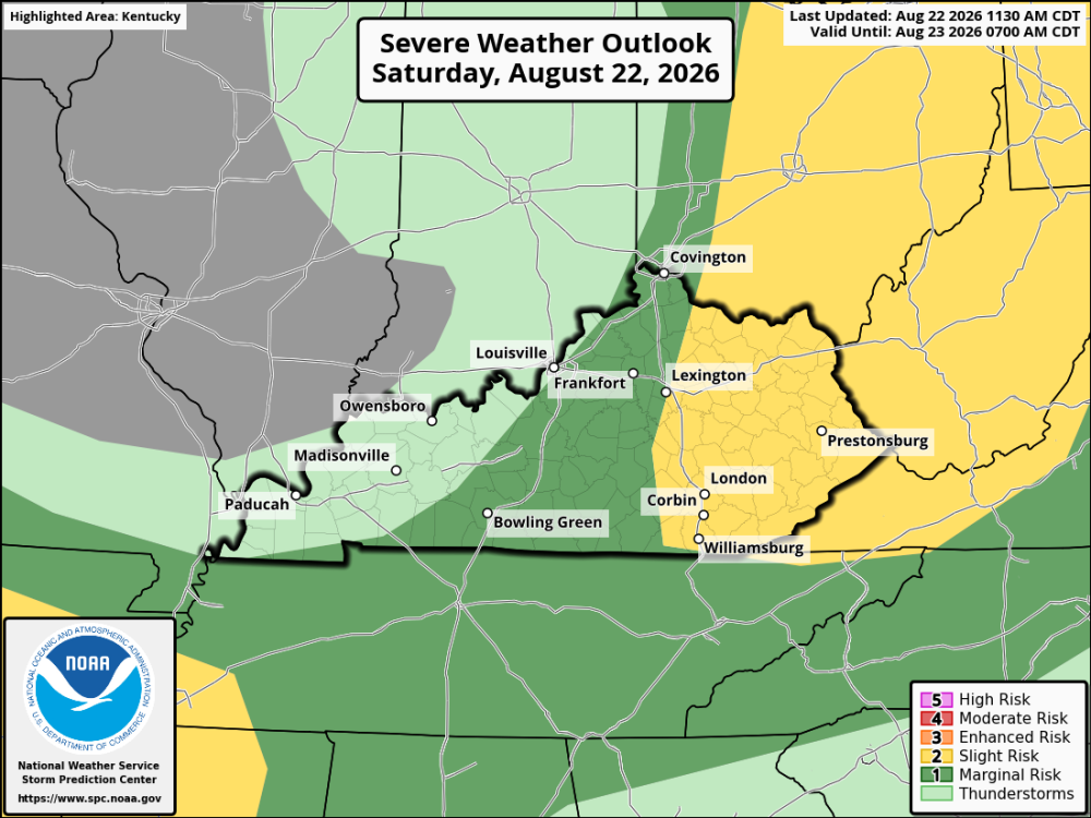
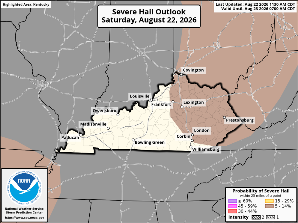
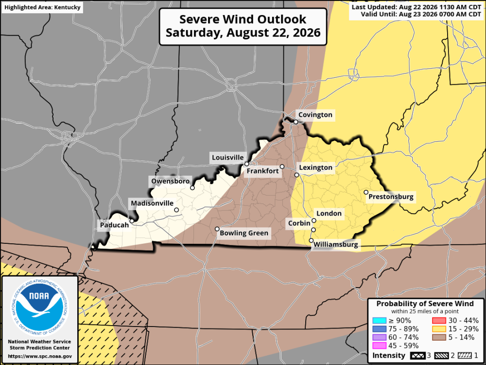 It's another warm and humid day across Kentucky and the Cincinnati area, but the weather could turn active later this afternoon. A cold front moving into the Ohio Valley will help trigger showers and thunderstorms. Storms should begin developing during the afternoon and could become more widespread as they move across the region. The main concern is damaging straight-line winds. Not all storms will be severe, but some may have strong wind gusts that can knock down tree limbs and cause isolated power outages. Heavy rain and frequent lightning may also occur. The best chance for stronger storms appears to be across Central and Eastern Kentucky, Northern Kentucky, and the Greater Cincinnati area. Storms in these areas could organize into clusters or short lines during the afternoon and evening, increasing the damaging wind threat. Western Kentucky may see more isolated storm activity, but any storm that develops could still produce a brief period of strong winds. Not everyone will see a severe storm, but those that do could experience a quick hit of strong, damaging winds. Keep an eye on the sky!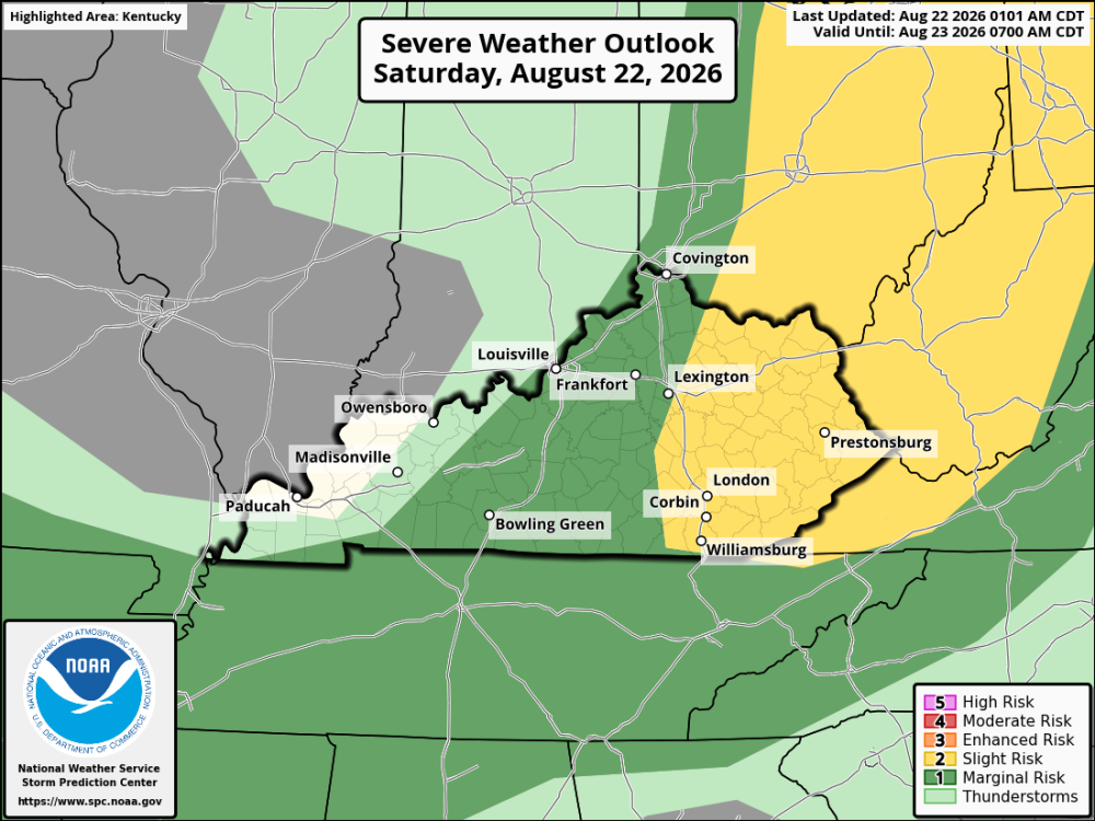
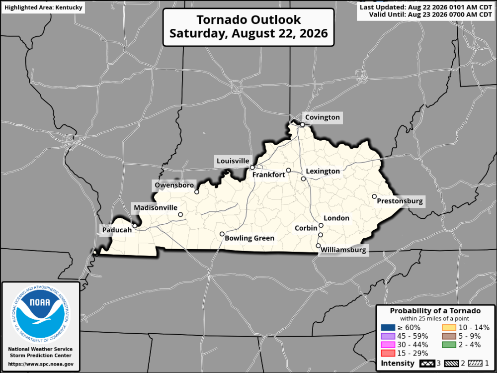
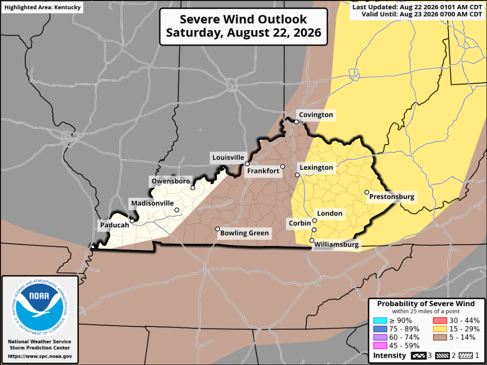 Update for tonight's games Friday night is shaping up to be a good night for high school football across Kentucky. It will still be warm at kickoff, but temperatures will gradually fall through the evening, making it more comfortable under the lights. WESTERN KENTUCKY A warm start around the 80s at kickoff, with temperatures falling into the mid-70s by halftime and the low 70s late in the game. Overall, it looks like a dry and pleasant night for football. CENTRAL KENTUCKY Temperatures will be near 80 at kickoff, falling through the 70s during the game and reaching the low 70s by the fourth quarter. There may be a little more cloud cover, and a stray shower can't be ruled out early, but most areas should enjoy a good night under the lights. EASTERN KENTUCKY Look for temperatures in the upper 70s at kickoff, cooling into the low 70s by halftime, and the upper 60s to near 70 late in the game. A shower or storm is possible early in a few spots, but conditions should become more comfortable as the evening goes on. NORTHERN KENTUCKY A warm kickoff with temperatures around 80, then falling into the mid-70s by halftime and the low 70s by the end of the game. Overall, it looks like a comfortable Friday night for football, especially later in the evening. Most of Kentucky is looking at a good night for Friday night football. The main thing to watch will be any isolated showers or thunderstorms early in the evening, but temperatures should fall nicely once the sun goes down.Sorry, I forgot to add the forecast for northern Kentucky. Mrs nWo fixed steak, baked potato, and salad, so I was in a hurry to eat! Northern Kentucky is looking at a warm start to the night, but it should become more comfortable as the game goes on. Expect temperatures to be around 80–83° at the 7 PM EDT kickoff, then fall into the mid- to upper 70s by halftime. By the fourth quarter, temperatures should be down in the low 70s. Overall, it looks like a good night for Friday night football. Fans may want to keep an eye on the sky early, but the evening should become more comfortable once the sun goes down.Friday night is shaping up to be a pretty good night for high school football across Kentucky. WESTERN KENTUCKY Kickoff temperatures will be near 80° at 7 PM CDT, falling into the mid-to-upper 70s by halftime and the low to mid-70s by the end of the game. Overall, it looks like a pleasant night with great football weather. CENTRAL KENTUCKY It will be around 80° at 7 PM EDT, with temperatures slipping into the upper 70s by halftime and the low 70s by the fourth quarter. It may still feel a little warm and humid early, and an isolated shower or thunderstorm can't be ruled out near kickoff, but most of the evening looks favorable for football. EASTERN KENTUCKY Temperatures should be in the upper 70s to near 80° at kickoff, dropping into the low to mid-70s by halftime and the upper 60s to low 70s late in the game. Conditions look generally quiet and comfortable, with a nice cool-down as the game goes on. It looks like a good Friday night for football across Kentucky. Western Kentucky appears to have the best chance for dry weather, while Central and Eastern Kentucky should keep an eye on the sky for an isolated shower or storm early in the evening.This will be my only post this weekend. In a couple of hours, my wife and I will be traveling to Bowling Green for a going-away party for one of our grandsons. He will be furthering his education at Temple University in Kyoto, Japan. He leaves late next week. Saturday: A couple of rounds of thunderstorms may move across the region. Some storms could become severe this afternoon into this evening. Damaging winds are the primary threat, although an isolated tornado cannot be ruled out. In addition, the heat index will approach 100. Sunday: More storms are possible on Sunday afternoon and evening. Once again, a few storms could be severe with damaging winds. The heat index will be near 100 again on Sunday.







Account
Navigation
Search
Configure browser push notifications
Chrome (Android)
- Tap the lock icon next to the address bar.
- Tap Permissions → Notifications.
- Adjust your preference.
Chrome (Desktop)
- Click the padlock icon in the address bar.
- Select Site settings.
- Find Notifications and adjust your preference.
Safari (iOS 16.4+)
- Ensure the site is installed via Add to Home Screen.
- Open Settings App → Notifications.
- Find your app name and adjust your preference.
Safari (macOS)
- Go to Safari → Preferences.
- Click the Websites tab.
- Select Notifications in the sidebar.
- Find this website and adjust your preference.
Edge (Android)
- Tap the lock icon next to the address bar.
- Tap Permissions.
- Find Notifications and adjust your preference.
Edge (Desktop)
- Click the padlock icon in the address bar.
- Click Permissions for this site.
- Find Notifications and adjust your preference.
Firefox (Android)
- Go to Settings → Site permissions.
- Tap Notifications.
- Find this site in the list and adjust your preference.
Firefox (Desktop)
- Open Firefox Settings.
- Search for Notifications.
- Find this site in the list and adjust your preference.