.png.ffa34568722b20f38e3c3ecfcb9a2cd2.png)


nWo
-
Posts
25,592 -
Joined
-
Last visited
-
Days Won
2
Everything posted by nWo
-
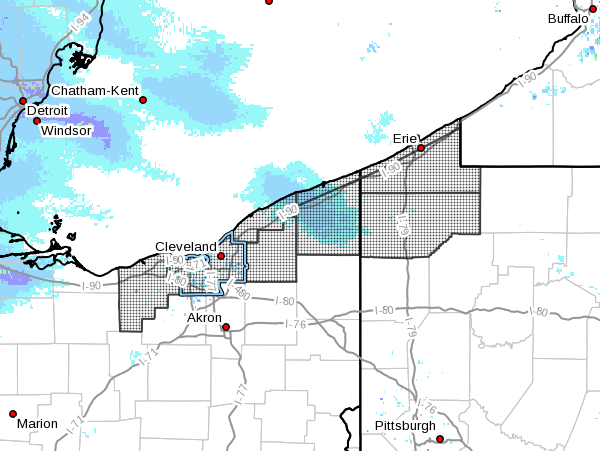
@gold sunrise You are now under a Winter Storm Warning Lorain-Cuyahoga-Lake-Geauga-Ashtabula Inland-Ashtabula Lakeshore- Northern Erie-Southern Erie-Crawford- Including the cities of Lorain, Cleveland, Mentor, Chardon, Jefferson, Ashtabula, Erie, Edinboro, and Meadville 1046 PM EDT Sun Mar 12 2017 ...WINTER STORM WARNING IN EFFECT FROM 5 PM MONDAY TO 8 PM EDT WEDNESDAY... The National Weather Service in Cleveland has issued a Winter Storm Warning for heavy snow, which is in effect from 5 PM Monday to 8 PM EDT Wednesday. The Winter Storm Watch is no longer in effect. * Accumulations...6 to 10 inches of snow from Monday evening through Tuesday afternoon, with additional lake effect snow continuing at times through Wednesday. * Timing...Snow will begin Monday afternoon and increase in intensity Monday night into Tuesday morning. Occasional snow showers will continue Tuesday night and Wednesday. * Impacts...Difficult driving conditions with reduced visibility and snow covered roads. * Winds...Northeast winds 10 to 20 mph Monday night becoming north 15 to 25 mph with gusts up to 35 mph on Tuesday. * Temperatures...In the 20s. PRECAUTIONARY/PREPAREDNESS ACTIONS... A Winter Storm Warning for heavy snow is issued when severe winter weather conditions are expected or occurring. Significant amounts of snow are forecast that will make travel dangerous. Only travel in an emergency. If you must travel...keep an extra flashlight...food...and water in your vehicle in case of an emergency.

-
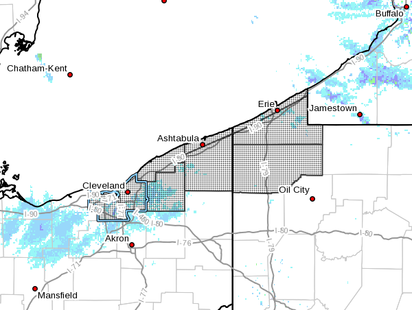
@gold sunrise There is now a Winter Storm Watch out for Cleveland starting Monday afternoon into Wednesday. Any where from 6-10 inches are expected. URGENT - WINTER WEATHER MESSAGE National Weather Service Cleveland OH 404 AM EDT Sun Mar 12 2017 ...HEAVY SNOW EXPECTED MONDAY EVENING THROUGH WEDNESDAY... .A complex winter storm will affect the Snowbelt of northeast OH and northwest PA early this week. Low pressure will track through the Ohio Valley on Monday bringing widespread snow to the area Monday night into Tuesday. Snowfall amounts across this area will be enhanced due to additional moisture from Lake Erie. The snow will then transition to lake-effect Tuesday night into Wednesday as northerly flow continues across the area. OHZ011>014-089-PAZ001>003-121615- /O.NEW.KCLE.WS.A.0002.170313T2100Z-170316T0000Z/ Cuyahoga-Lake-Geauga-Ashtabula Inland-Ashtabula Lakeshore- Northern Erie-Southern Erie-Crawford- Including the cities of Cleveland, Mentor, Chardon, Jefferson, Ashtabula, Erie, Edinboro, and Meadville 404 AM EDT Sun Mar 12 2017 ...WINTER STORM WATCH IN EFFECT FROM MONDAY AFTERNOON THROUGH WEDNESDAY EVENING... The National Weather Service in Cleveland has issued a Winter Storm Watch, which is in effect from Monday afternoon through Wednesday evening. * Accumulations/Timing...6 to 10 inches of snow late Monday afternoon through Tuesday afternoon, with additional lake- effect snow possible Tuesday night through Wednesday. * IMPACTS...Heavy snow could produce very difficult driving conditions with very poor visibility and snow covered roads. * Winds...North 10 to 20 mph with gusts up to 30 mph. * Visibilities...As low as a quarter of a mile at times. * Temperatures...In the 20s. PRECAUTIONARY/PREPAREDNESS ACTIONS... A Winter Storm Watch is issued when there is a potential for significant snow...sleet...or ice accumulations that may impact travel. Continue to monitor the latest forecast and prepare for possible warnings.
-
It will mainly depend on timing. What I just went over, GFS is showing the temps will be above freezing until early Tuesday morning. Temps look to fall during the day on Tuesday into the low to mid 20s by Tuesday evening. For now the moisture looks to move out ahead of the temperature drop. Maybe a mix and very light if any accumulations as the temperature drops before the precipitation moves out completely. The NAM is showing that the below freezing temps won't move in until Tuesday evening so timing will be every thing. Those is SE and EKY should pay attention to the weather at this time. If the predicted system shifts westward members in that area could see some nice accumulations.
-
709 AM CST Sat Mar 11 2017 ...WINTER WEATHER ADVISORY IN EFFECT UNTIL 11 AM CST THIS MORNING... THE NATIONAL WEATHER SERVICE IN Paducah HAS ISSUED a Winter Weather Advisory...WHICH IS IN EFFECT until 11 AM CST this morning. * TIMING: Mainly early today. * MAIN IMPACT: Most snow accumulations up to an inch or so will be on grassy areas, trees and vehicles. However, where the snow comes down the hardest, some slushy accumulations may occur on roadways, especially on bridges and overpasses. PRECAUTIONARY/PREPAREDNESS ACTIONS... A winter weather advisory means that periods of snow...sleet...or freezing rain may cause travel difficulties. Be prepared for slippery roads and limited visibilities...and use caution while driving.
-
Here's my updated look at the snow for Saturday into Sunday. It now appears that most of the snow has moved even further south with the heaviest possible accumulations in WKY. From the Louie B Nunn PKWY southward dusting to 1" of accumulations. Western Kentucky could see anywhere from 2-4". This looks to be west of The Land Between the Lakes area. I'll be back in a few with a new thread for the possible snow for early next week.
-
First look at possible accumulations for Saturday. I'm thinking from a dusting to about 1" mainly south of I-64. I will update later today. Also give my first thoughts on the second system that looks to come through early next week.
-
-
I'll make my first call on snow tomorrow morning. The possible snow this weekend looks to be just the start of winter returning to Kentucky. There appears to be a second more potent system poised to pass through Kentucky around Tuesday of next week.
-
-
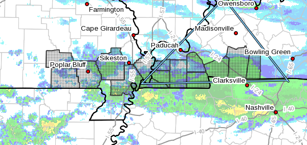
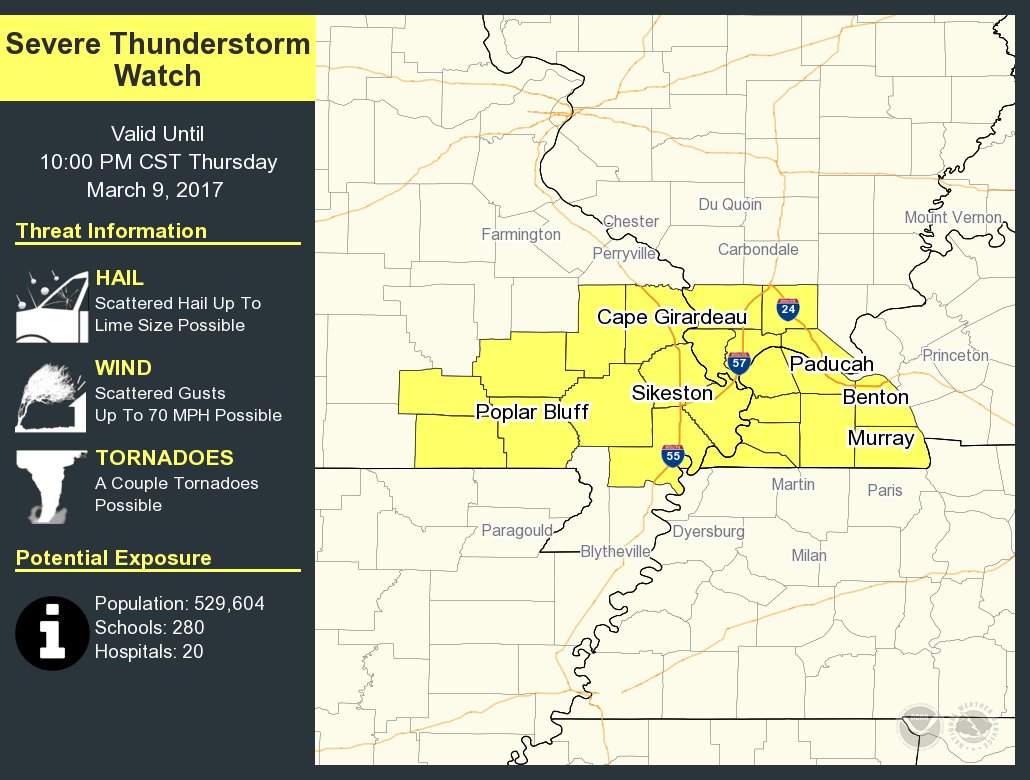
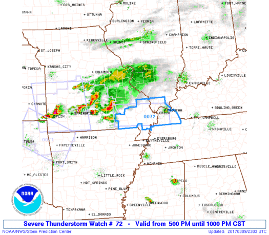
URGENT - IMMEDIATE BROADCAST REQUESTED Severe Thunderstorm Watch Number 72 NWS Storm Prediction Center Norman OK 500 PM CST Thu Mar 9 2017 The NWS Storm Prediction Center has issued a * Severe Thunderstorm Watch for portions of Southern Illinois Western Kentucky Southeast Missouri * Effective this Thursday afternoon and evening from 500 PM until 1000 PM CST. * Primary threats include... Scattered large hail and isolated very large hail events to 2 inches in diameter possible Scattered damaging wind gusts to 70 mph possible A tornado or two possible
-
A quick hit. I'm really growing confident in the accumulating snow coming this weekend. The first system to hit late Saturday into Sunday looks, for now, to be mainly in and along the southern Kentucky. Totals are still waffling but should get some good info on the accumulation totals later today. Now, this doesn't look like our only chance for snow. The modeling data is showing another system to hit Kentucky early next week. One thing of note with the very cold temps forecast for this weekend there looks to be some significant damage possible for trees and flowers already in bloom. I'll try to post an update this evening. Worked almost 12 yesterday and have to go into work early this morning. So I can't really go over this morning's data like I like to.
-
maybe 2-4" this weekend. These are just the totals at this time. I'll post more detailed info by Friday. I worked almost 12 hours yesterday and have to go to work early this morning. So I don't really have the time to really go into the model data.
-
All of the models I use, NAM, GFS and CFS are now showing a system that could produce snow hitting Kentucky this weekend. Where they differ is the timing and track. I'm not ready to forecast any numbers but I will say this maybe the first winter storm of the season.
-
Yep temps in the low 20s with possible snow.
-
Looks like we have two shots at accumulating snows. Saturday into Sunday then again Monday through Tuesday. So check back for updates.
-
Thanks, I'm going to wait on giving any totals. Just looked over the 18z GFS run. Still showing snow but as expected there is a back and forth on the path of the system that will come through this weekend. The path will make all the difference on who gets snow and how much snow accumulates. Should get a good read on the possible system tomorrow.
-
The midday run of the GFS almost matched exactly the CFS from this morning. So that means a good chance of getting what it is showing. I may give some totals this evening after the 18z run.
-
This weekend is looking to be.... Both the CFS and GFS models are coming into agreement on the type of precipitation for this Saturday into Sunday. The differ on the timing. The GFS has in coming in sooner. Good chance we'll see some snow. One tell tale sign is now the Storm Prediction Center is no longer showing the chance of severe weather for WKY. By Saturday night almost the entire state could see temps in the mid to upper 20s. A low pressure systems looks to form around Texas and move up through Tennessee. This combination could produce some decent snow for much of Kentucky. It all depends on the track of the Low Pressure system. The model are taking in on a more southerly track the last few runs. I'm not ready to say how much snow yet. Two main reasons. First, the accumulation totals will waver up and down until we get closer to the time period. Second, people wouldn't believe what they are showing anyway. :thumb: I'll try and post an update this evening.
-
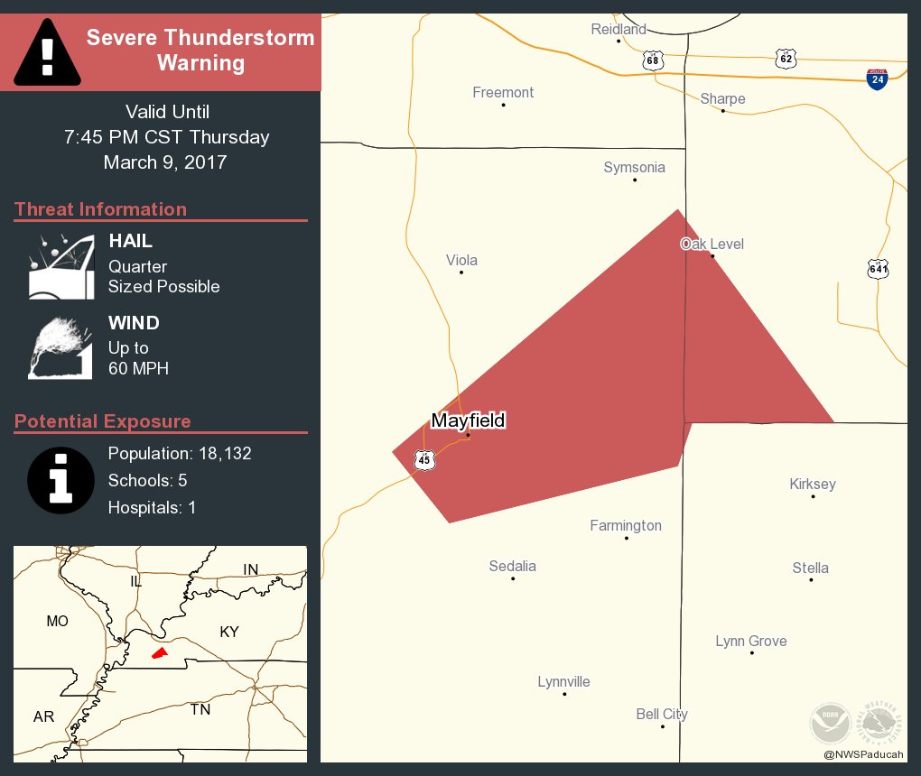
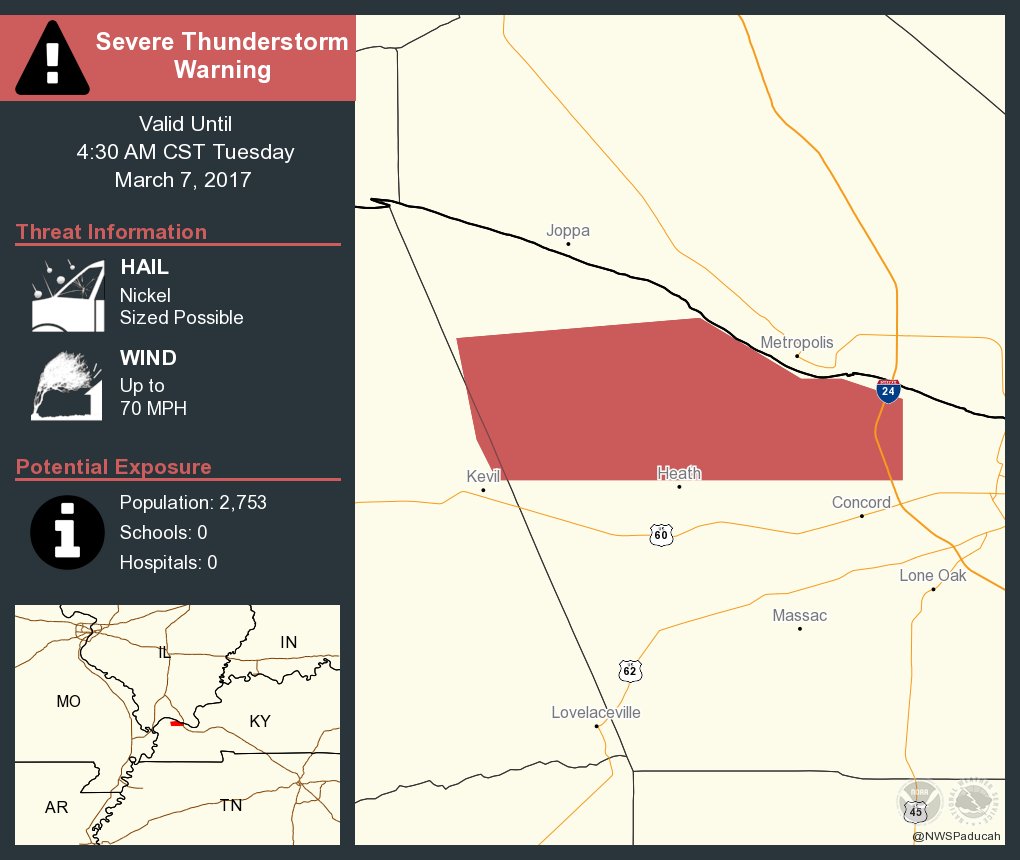
This is just shows that there can be thunderstorm warnings issued without a watch being issued.
-
-
-
@ggclfan You might need a pair of these to run in this weekend. :thumb:
-
:lol:
-
The cold may not be the only thing you'll be running in! :thumb:
-
Some are not going to like what the GFS is now showing for this weekend. Snow is now back in the picture. I'm not going to post any totals tonight because things will more than likely fluctuate between now and then. All I'm willing to say tonight is if the trend continues winter is definitely not over.