.png.ffa34568722b20f38e3c3ecfcb9a2cd2.png)


nWo
-
Posts
25,551 -
Joined
-
Last visited
-
Days Won
1
Posts posted by nWo
-
-
-
-
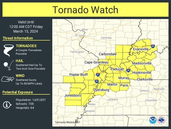
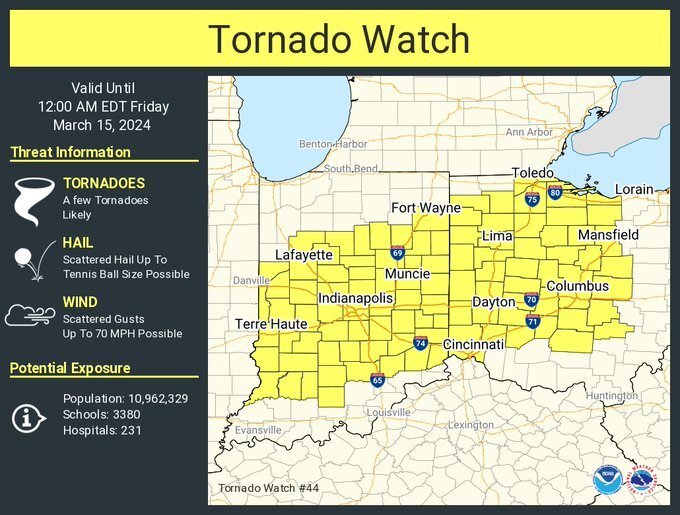
URGENT - IMMEDIATE BROADCAST REQUESTED
Tornado Watch Number 44
NWS Storm Prediction Center Norman OK
415 PM CDT Thu Mar 14 2024The NWS Storm Prediction Center has issued a
* Tornado Watch for portions of
much of Indiana
western and central Ohio* Effective this Thursday afternoon and evening from 415 PM until
1100 PM CDT.* Primary threats include...
A few tornadoes likely
Scattered large hail and isolated very large hail events to 2.5
inches in diameter possible
Scattered damaging wind gusts to 70 mph possibleSUMMARY...Strong/severe thunderstorm development is expected over
the next couple of hours across much of Indiana, and spreading into
western Ohio thereafter. Along with large hail and locally damaging
wind gusts, a few tornadoes will also be possible into this evening.The tornado watch area is approximately along and 65 statute miles
north and south of a line from 25 miles north northwest of Terre
Haute IN to 35 miles north northeast of Columbus OH. For a complete
depiction of the watch see the associated watch outline update
(WOUS64 KWNS WOU4).PRECAUTIONARY/PREPAREDNESS ACTIONS...
REMEMBER...A Tornado Watch means conditions are favorable for
tornadoes and severe thunderstorms in and close to the watch
area. Persons in these areas should be on the lookout for
threatening weather conditions and listen for later statements
and possible warnings. -
-
This watch has expired.
-
-
-
29 minutes ago, Kentucky Windage said:
Unlike the last storm that rolled through, this go around we're getting the day time heating with the sun being out. Humidity doesn't feel all that ripe but who knows how that'll play out as the front approaches.
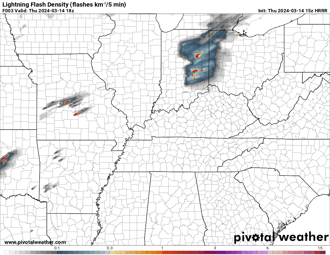
The major danger window for Kentucky will be later this evening and throughout the night. This is illustrated in the lightning flash intensity map below. It covers from 2:00 PM Thursday to 5:00 AM Friday.

-
 1
1
-
-
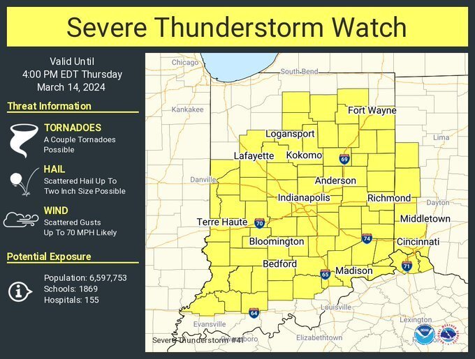
URGENT - IMMEDIATE BROADCAST REQUESTED
Severe Thunderstorm Watch Number 41
NWS Storm Prediction Center Norman OK
1050 AM EDT Thu Mar 14 2024The NWS Storm Prediction Center has issued a
* Severe Thunderstorm Watch for portions of
much of Indiana
far northern Kentucky
parts of western Ohio* Effective this Thursday morning and afternoon from 1050 AM
until 400 PM EDT.* Primary threats include...
Scattered damaging wind gusts to 70 mph likely
Scattered large hail and isolated very large hail events to 2
inches in diameter possible
A tornado or two possibleSUMMARY...A broken band of thunderstorms is expected to continue
intensifying this morning and into this afternoon, as it moves
across Indiana and vicinity. Large hail and damaging winds will be
possible, along with potential for a couple of brief tornadoes
associated with stronger cells within the broader line of storms.The severe thunderstorm watch area is approximately along and 70
statute miles east and west of a line from 60 miles north northwest
of Muncie IN to 50 miles south of Bloomington IN. For a complete
depiction of the watch see the associated watch outline update
(WOUS64 KWNS WOU1).PRECAUTIONARY/PREPAREDNESS ACTIONS...
REMEMBER...A Severe Thunderstorm Watch means conditions are
favorable for severe thunderstorms in and close to the watch area.
Persons in these areas should be on the lookout for threatening
weather conditions and listen for later statements and possible
warnings. Severe thunderstorms can and occasionally do produce
tornadoes.-
1
-
-
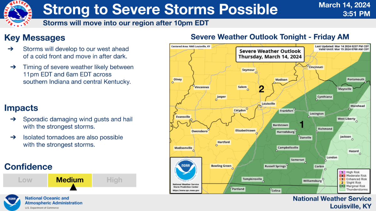
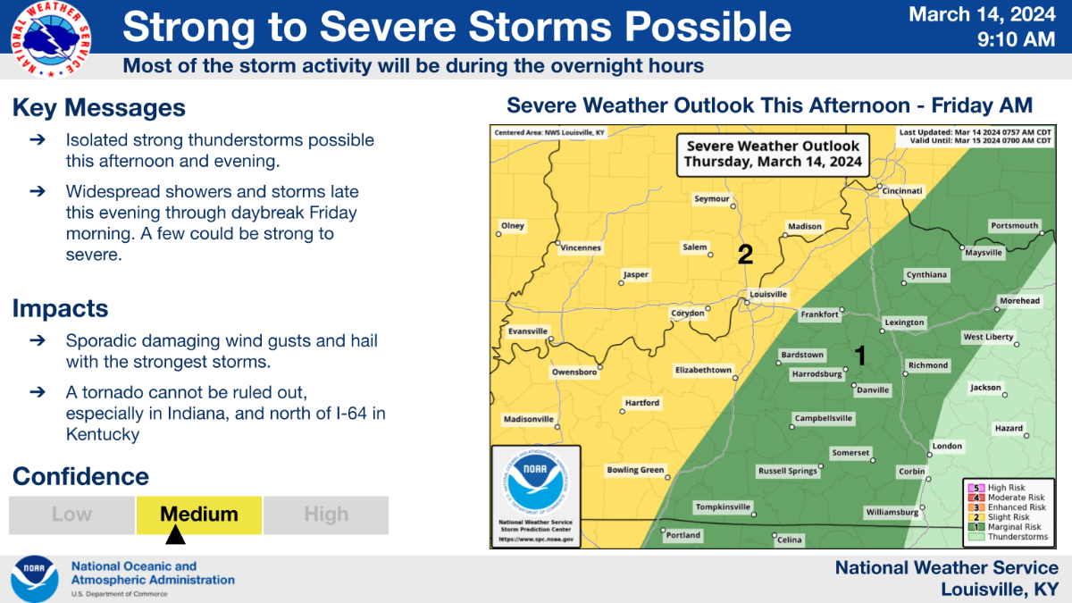
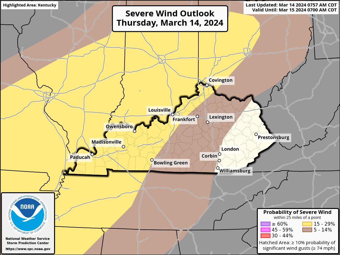
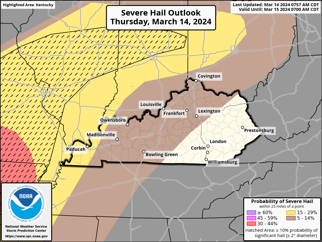
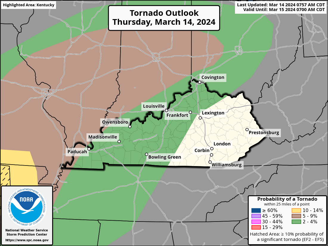
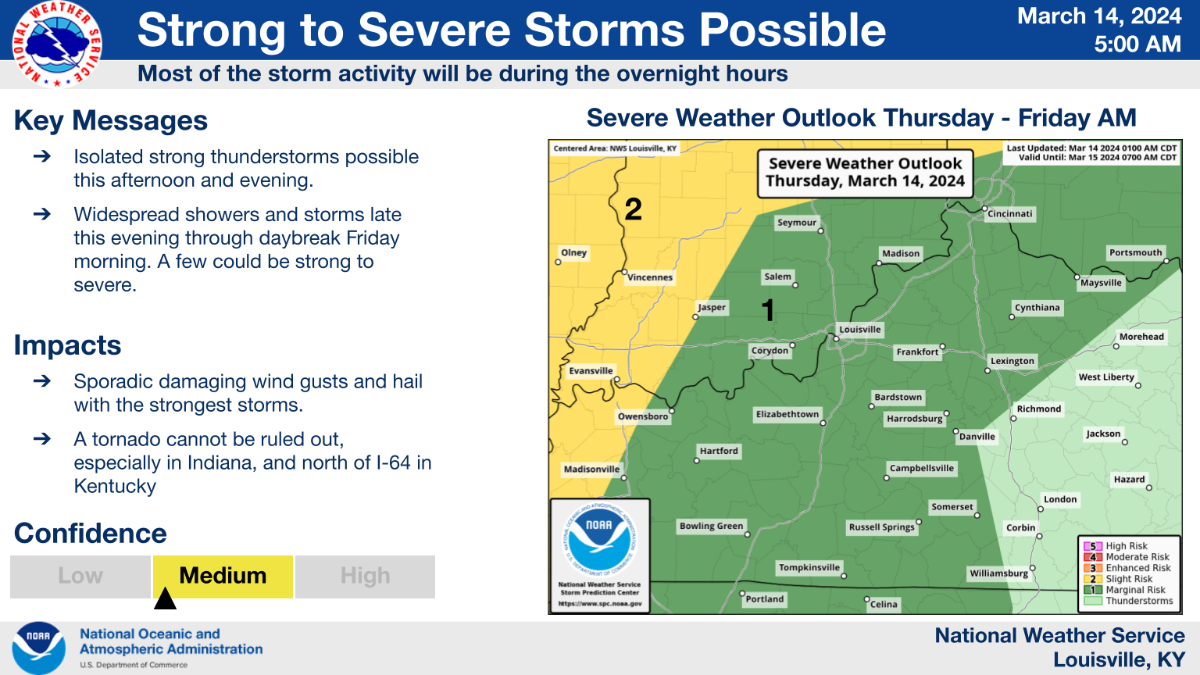
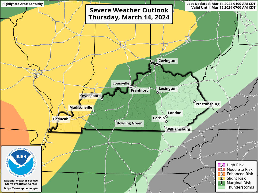
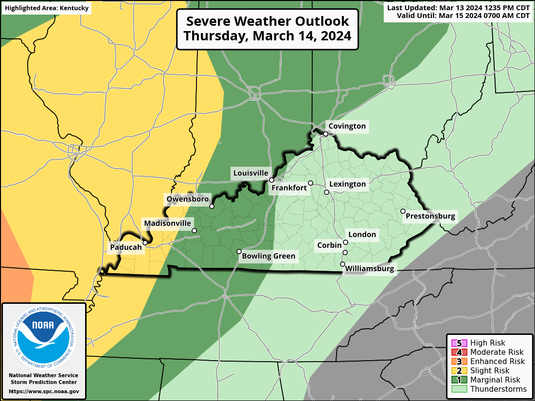
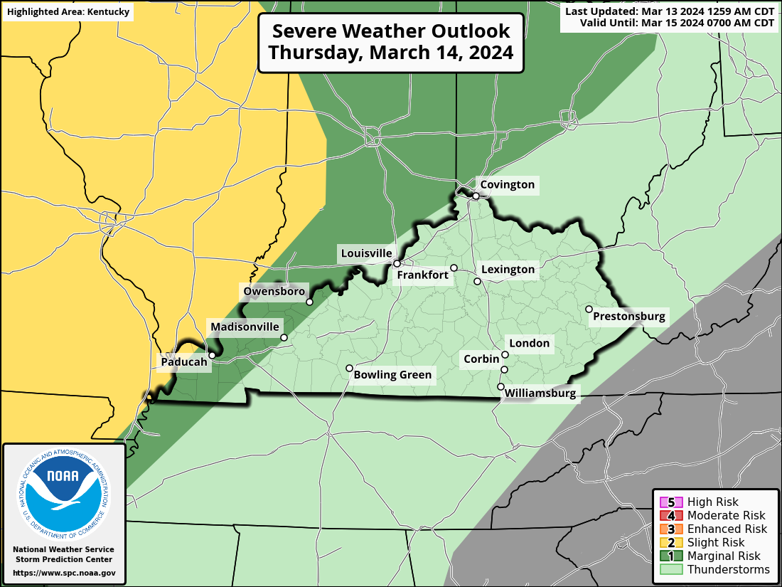
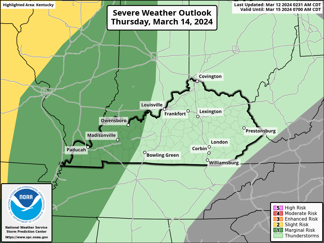
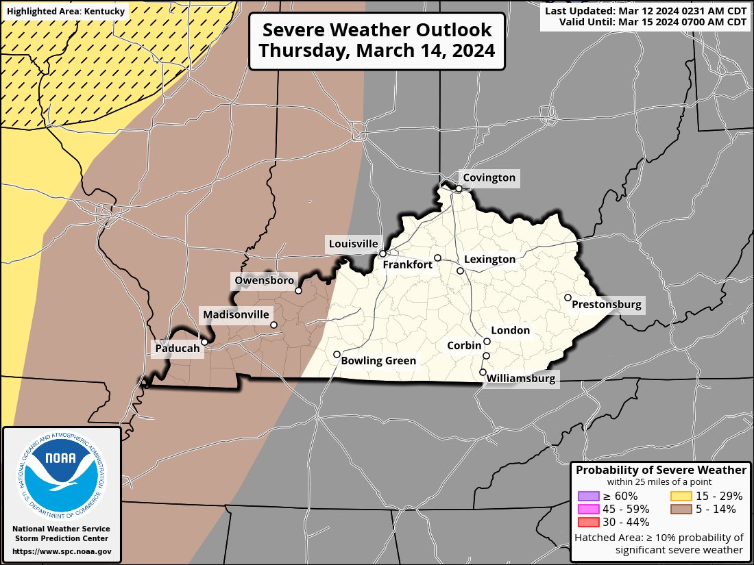
Since this morning, there is a greater chance of severe weather. The level 2 Slight Risk area has been extended by the Storm Prediction Center to about the I-65 corridor. Additionally, the Cincinnati/NKY region is included by extending it along the Ohio River.
Thunderstorm bands are still lingering over parts of Illinois and Missouri. As it moves quickly east-northeastward this morning, this activity could continue to present isolated chances for one or more embedded tornadoes as well as intermittent severe gusts. Threats from severe gusts and tornadoes can concentrate along the warm front. However, the early-morning instability minimum in the boundary layer may potentially mitigate the catastrophic danger locally. In certain areas of IN and possibly KY, the combined complex may be re-intensifying to some extent at this time.
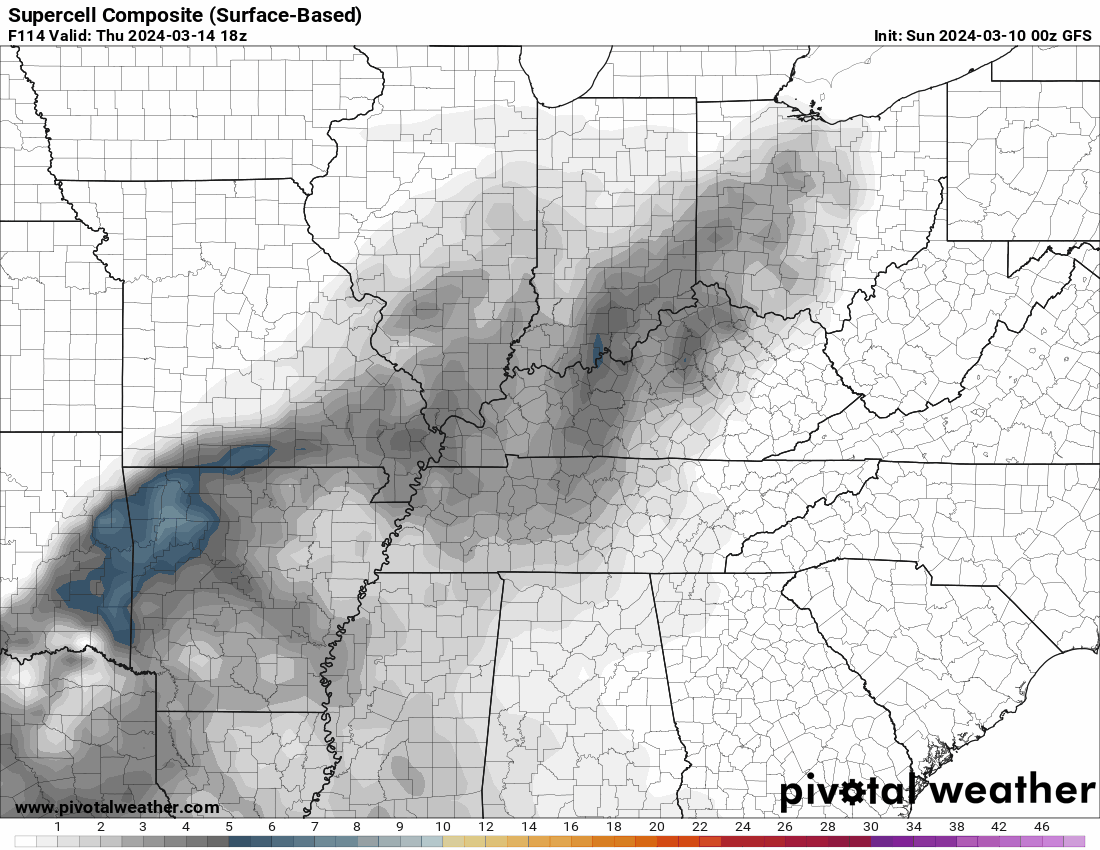
An additional possible round of convection this afternoon and tonight appears to pose a conditionally serious threat for tornadoes, big to very large hail, and severe wind. Long-lasting supercells and bending clusters may develop in areas of the atmosphere that are not disturbed by outside influences.
-
I just received this from the National Weather Service-Louisville office:
-
Western Kentucky:
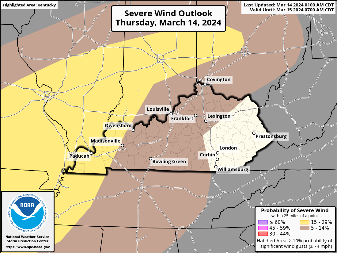
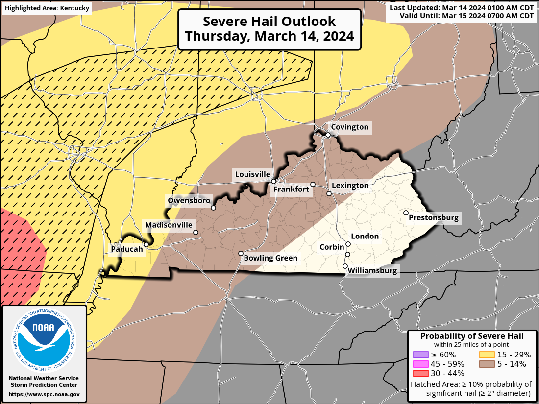
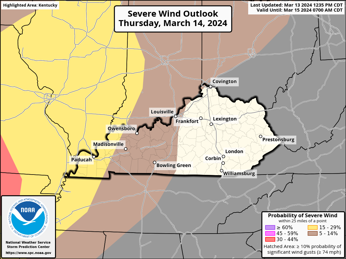
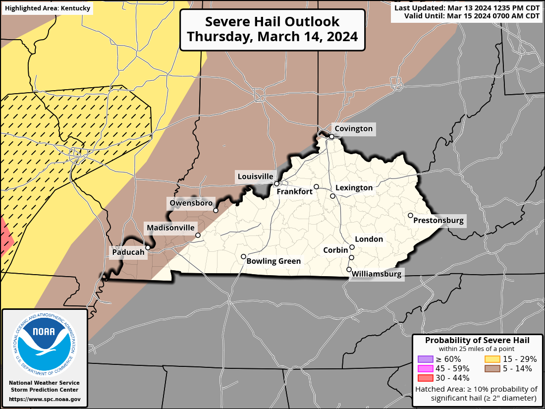
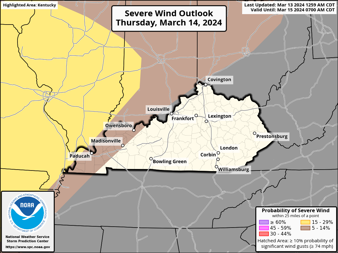
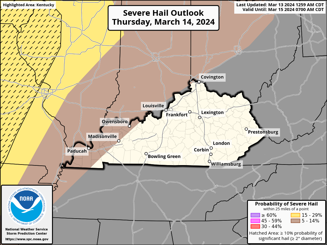
Isolated to scattered severe storms are possible, with slightly higher chances across southeast Missouri and southwest Illinois. Stay aware of the latest updates. For now, the timing is after 3 pm Thursday through the early overnight hours. Primary Hazards: Quarter-size hail (1” Diameter), Damaging wind gusts to 60 mph Isolated tornadoes are possible The exact timing of the frontal boundary and associated line of thunderstorms is still uncertain, as is the eastward extent of the severe threat into Kentucky and southwest Indiana.
Rest of Kentucky:
Widespread rain and thunderstorms are possible Thursday night into Friday morning. Embedded strong to severe storms may be possible during this timeframe. Damaging wind gusts, hail, and an isolated tornado are all possible hazards.
-
For some areas of western Kentucky, the serious threat has intensified. There is a chance that the activity, which was first over the Mid Mississippi Valley, will eventually move from elevated to surface-based—or at least near-surface-based—as it interacts with the warm front moving northward across the area. There may be a chance of an isolated tornado as well as updraft organization under certain circumstances. Stronger storms or thunderstorm clusters may also produce huge hail and damaging gusts.
-
On Thursday, there may be some strong to severe storms over parts of western Kentucky.There is a chance that the activity that was first over the Mid MS Valley will interact with the warm front moving northward across the area, moving from high to surface-based—or at least near-surface-based—as it goes eastward. Forecast confidence is limited by uncertainties about the front's position and the way convection moves out of the Mid-MS Valley. Nevertheless, upcoming data will be carefully examined, and upgrades might be taken into account in upcoming outlooks.
-
A level 1 Marginal Risk Area has been declared by the Storm Prediction Center for portions of western Kentucky for Thursday.
-
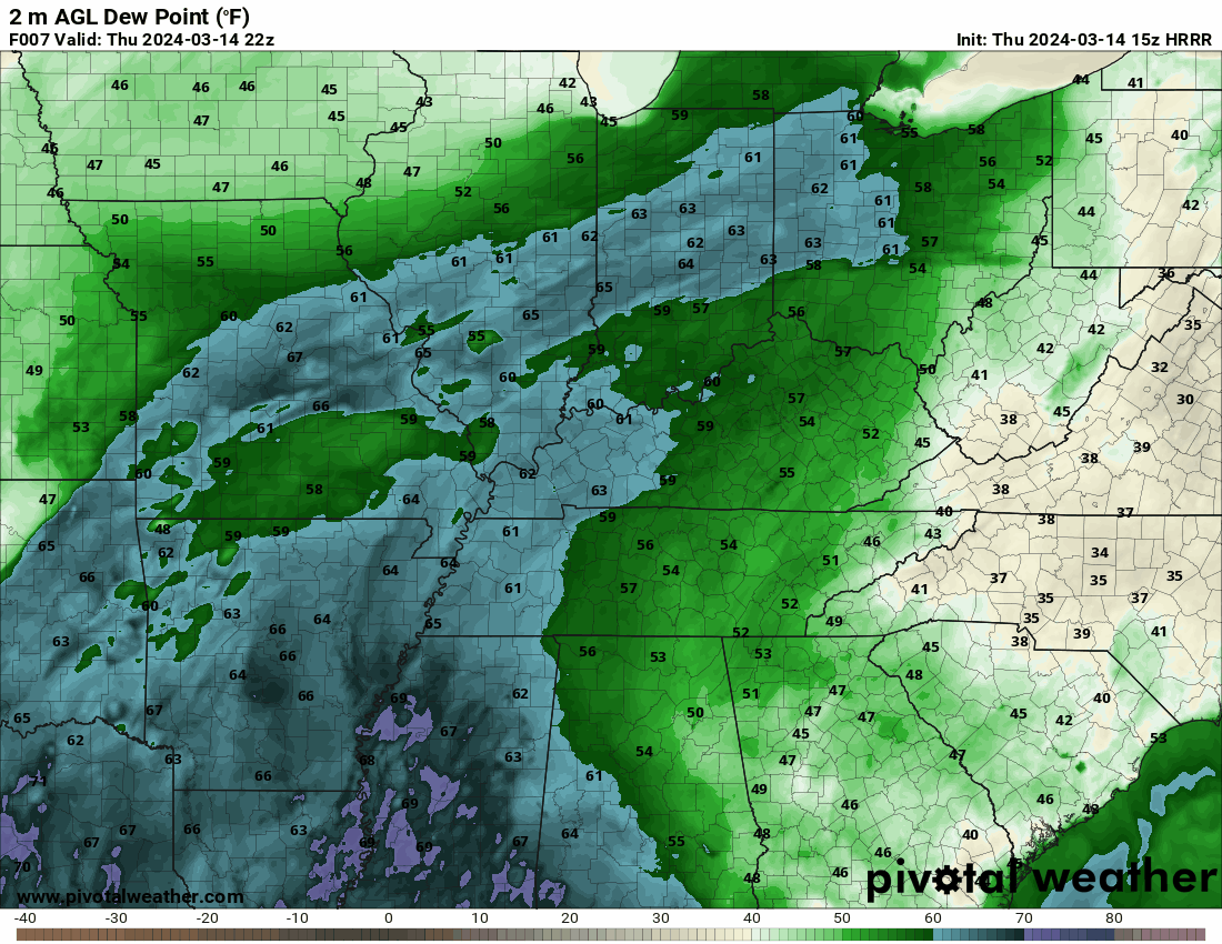
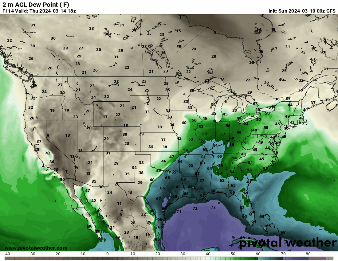
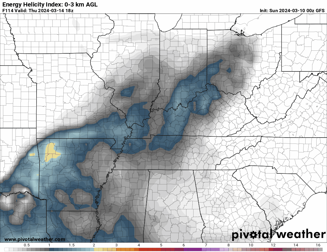
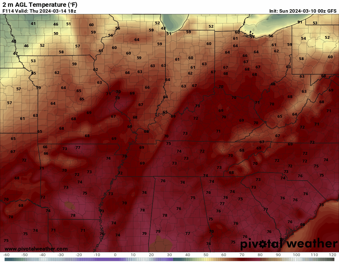
This will only be a quick overview. There seems to be a possibility of thunderstorms on Thursday afternoon and into the evening, with some of them perhaps intense to severe. Since nothing is certain this far off, I just wanted to let you know in case something does come to pass. Late on Thursday morning, Kentucky should see a few isolated showers or storms move in from the northwest. In the afternoon, they might get stronger. For a sizable portion of Kentucky, mostly west of I-75, dewpoints might reach the mid-60s. The temperature might be in the low to mid-seventies. The EHI indicates that, prior to the system that may produce the storms, circumstances may be conducive to the creation of strong to severe storms.
-
Make a plan today. Your family may not be together if a disaster strikes, so it is important to know which types of disasters could affect your area. Know how you’ll contact one another and reconnect if separated. Establish a family meeting place that’s familiar and easy to find.
-
-
-
-
-
-
Severe weather can occur anytime of the year, and can bring many different hazards and impacts to the region. Severe Weather Awareness week is your reminder that you need to be Weather Ready for all types of hazards, such as tornadoes, severe thunderstorms, large hail, lightning, heavy rain, flooding, and high winds. New for 2024, NWS Louisville will feature a day dedicated to Beach Safety. Many people from our state travel for Spring Break and Summer Vacation to the beach, and may not be as prepared for severe weather or beach hazards as the locals are. All week long, the National Weather Service office in Louisville, KY will be sharing information on how to prepare for severe weather, which will be viewable on our social media platforms (Facebook and Twitter). Please Share/Retweet to share this knowledge with others.
-
All watches have been canceled.
Storm Reports March 14-15
in Weather
Posted
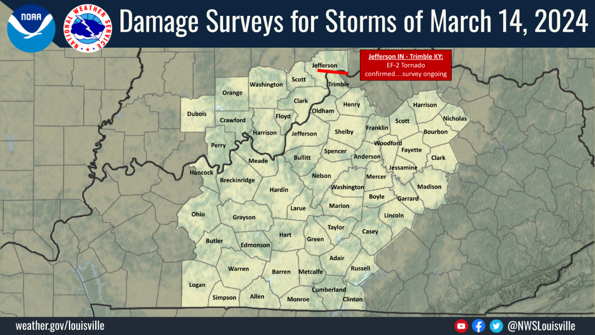
Thursday's storm was a classic example of a supercell. Look at this 3-D image of the storm, and compare its features to a textbook schematic. It dropped very large hail and produced a long-track EF-2 tornado that crossed the Ohio River three times.