.png.ffa34568722b20f38e3c3ecfcb9a2cd2.png)


nWo
-
Posts
25,551 -
Joined
-
Last visited
-
Days Won
1
Posts posted by nWo
-
-
The temperature here in Richmond is around 68 degrees. Also windy.
-

URGENT - IMMEDIATE BROADCAST REQUESTED
Tornado Watch Number 28
NWS Storm Prediction Center Norman OK
255 AM CST Wed Feb 28 2024The NWS Storm Prediction Center has issued a
* Tornado Watch for portions of
portions of central and eastern Kentucky
northern Middle Tennessee* Effective this Wednesday morning from 255 AM until 800 AM CST.
* Primary threats include...
A couple tornadoes possible
Scattered damaging wind gusts to 70 mph possible
Isolated large hail events to 1.5 inches in diameter possibleSUMMARY...Strong/locally severe thunderstorms continue to increase
in the vicinity of the Ohio River in northern Kentucky early this
morning, near the southern fringe of Tornado Watch 27. Storms are
forecast to continue to gradually spread east-southeastward over the
next several hours, with local risk for damaging winds and hail,
along with potential for a couple of tornadoes.The tornado watch area is approximately along and 35 statute miles
north and south of a line from 35 miles west southwest of Bowling
Green KY to 30 miles northeast of Jackson KY. For a complete
depiction of the watch see the associated watch outline update
(WOUS64 KWNS WOU8).PRECAUTIONARY/PREPAREDNESS ACTIONS...
REMEMBER...A Tornado Watch means conditions are favorable for
tornadoes and severe thunderstorms in and close to the watch
area. Persons in these areas should be on the lookout for
threatening weather conditions and listen for later statements
and possible warnings.
-
Mesoscale Discussion 0172
NWS Storm Prediction Center Norman OK
0201 AM CST Wed Feb 28 2024Areas affected...Southern Indiana...Southwest Ohio...Northern
KentuckyConcerning...Tornado Watch 27...
Valid 280801Z - 281000Z
The severe weather threat for Tornado Watch 27 continues.
SUMMARY...A tornado threat is expected to continue across WW 27 for
a few more hours. Isolated large hail and wind damage will also be
possible.DISCUSSION...The latest high-resolution radar imagery shows a couple
strong to severe short line segments over southern Indiana. This
convection is located along a corridor of instability, where the RAP
is estimating MLCAPE in the 500 to 1000 J/kg range. Water vapor
imagery and 500 mb analysis from the RAP have a shortwave trough and
fast moving vorticity max located in southwest Indiana. This feature
will continue to enhance lift and provide support for continued
strong thunderstorm development early this morning. The latest
WSR-88D VWP from Indianapolis has 0-6 km shear near 55 knots
suggesting that supercells with large hail and wind damage will be
possible. In addition, a 60 to 70 knot jet is analyzed at 850 mb
centered over far northern Kentucky which will continue to provide
strong low-level shear sufficient for an isolated tornado threat.
Furthermore, an increase in the severe threat could occur over the
next few hours in northern Kentucky as cells increase in coverage
within and just to the south of WW 27.
-
The storm I've been watching in western Kentucky near Owensboro just went severe.
-
I neglected to mention western Kentucky in the last post about tornado chances increasing.
-
Everyone should be alert this morning. Especially from the I-64 corridor northward.
-
The time window this morning from 3 to 9 am worries me the most. The Significant Tornado Parameter shows that there is a growing chance that a significant tornado will emerge. This does not guarantee that one will, but the likelihood is rising.
-
The storms are now starting to fire up in central Indiana.
-
9 minutes ago, Kentucky Windage said:
If this weather came through in the evening with the conditions it's carrying for this early morning, it may have been catastrophic. Just imagine if the sun came out to enhance that daytime heating. I'm not saying we lucked out, but it seems it could be worse. Staying weather alert tonight.
Thanks for all the hard work, @nWo!
Thank you. You are correct. The surface based CIN, or cap, is stopping the storm's development for now. It should start to have a lesser effect on storm development soon.
-
-
 1
1
-
-
-
Here are some maps from the HRRR model. It covers the period from 9 pm EST to 4 pm EST Wednesday. The first is the simulated radar. The second is the lightning intensity simulation. The last one is a significant tornado simulation. This shows where significant tornadoes could form.
I have a severe weather warning area set up for the Cincinnati/NKY area. I will try to send out any warnings on our Twitter page later tonight and early Wednesday morning.
-
1
-
-
Our next shot at severe weather will be at the start of next week.
-
2 minutes ago, theguru said:
You are doing a great job covering this one @nWo!
Thank you. This blew up pretty quickly. Oh, I forgot this temperature will be in the 20s Thursday morning.
-
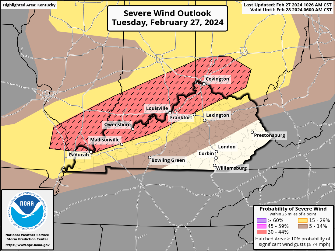
Here are the most recent details for tonight. Large hail, damaging gusts, and tornadoes—some of which may be significant—are all likely during severe thunderstorms that could last throughout the night over parts of northeastern Illinois and northwest Indiana, as well as the Lower and Middle Ohio Valley.
For tonight, the Ohio Valley's general expectations are still the same as those stated in the prior outlook. Activity will probably develop into swift-moving bowing structures as the night wears on, increasing the possibility of destructive wind gusts and even a few tornadoes. Strong tornadoes may also occur, along with damaging wind gusts of up to 75 mph due to the intensifying low-level flow. Those in the hatched areas have an increased chance to see the different weather modes.
Here's the predicted timing for tonight's severe weather:
-
-
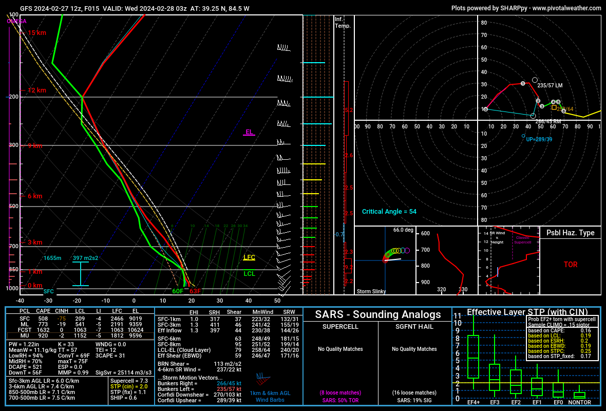
This is what I'm talking about when I say what the soundings are showing. This one is for a point near Cincinnati/NKY around 11 pm. Without going through everything, look at the bottom right box. This is where I get the possible tornado strength. Above it is the possible hazard type. It tells me what the possible hazard type is.
This one is for western Kentucky.
-
This is what I was talking about. The data starts around 7:pm this evening.
-
6 minutes ago, theguru said:
The weather is wild you take 75 and sunny from yesterday and put it with rain, thunderstorms, wind, maybe hail, and then mid 20s by tomorrow, ugh.
Keep us posted @nWo!
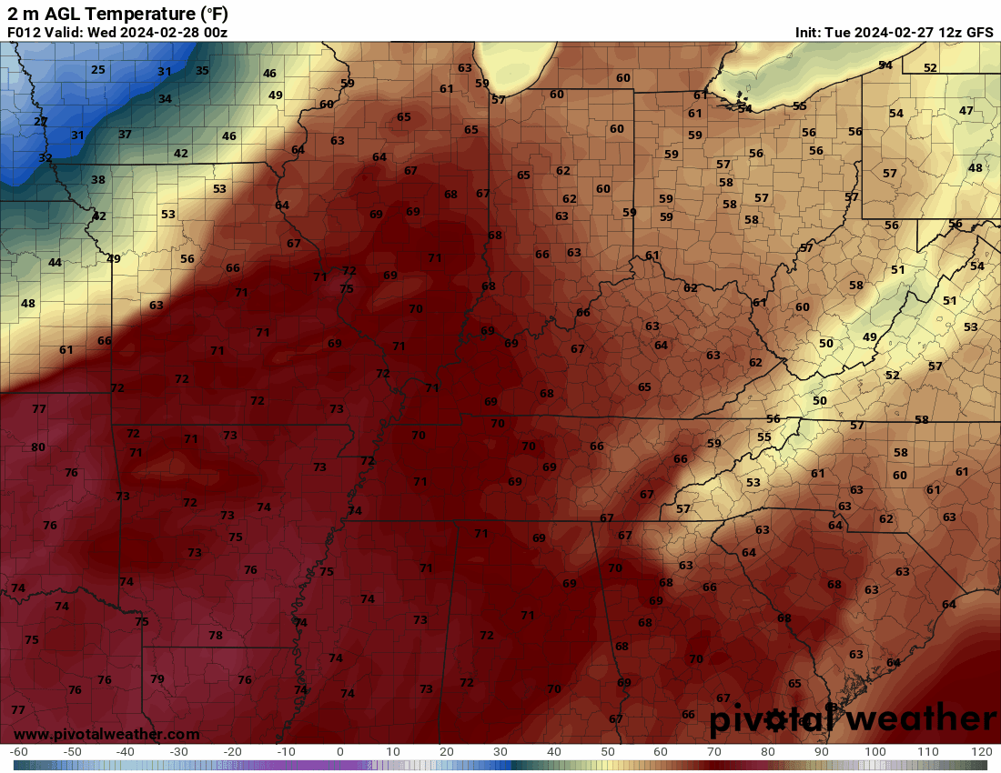
Sure thing. I was just checking some models, and it appears that the temperatures will rise some before the storms come through. One thing concerning me is that the 60-degree dewpoints are now expected to extend to the Cincinnati/NKY area. There's a conference call by the National Weather Service-Louisville office this afternoon around 2:30. I'll post what I learn around 4 or so.
-
3
-
-
14 minutes ago, TheDeuce said:
I was getting my data together. After I posted, I saw you did too.
-
 1
1
-
-
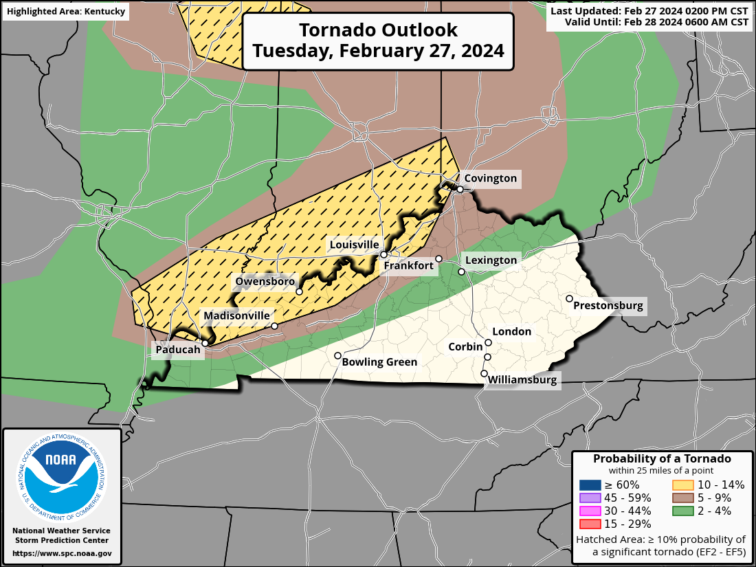
I just checked the SARS sounding for possible tornado strength. It shows that tornadoes of up to EF-3 strength may be possible within a 25-mile radius of a given point in the Enhanced Risk Area.
-
1
-
-
Parts of the Ohio Valley and southern Great Lakes may see severe thunderstorms from late this afternoon into the night, accompanied by big hail, strong gusts, and tornadoes, some of which may be quite large.
The majority of 12z information indicates that isolated thunderstorm development will start around or after dusk. Overnight, these storms will get stronger and move generally eastward along the Ohio River, entering portions of Wisconsin, Pennsylvania, and Ohio by early Wednesday morning. The first storms could be isolated and have enough vertical shear to form supercell structures that can contain all major risks. With a greater chance of destructive wind gusts and a few tornadoes, the activity is expected to transform into swiftly moving bowing structures as the night wears on. There is also a chance of a powerful tornado or two.
. The Storm Prediction Center has added an Enhanced risk area for this scenario overnight.
..
-
1
-
1
-
-
-
The threat of a tornado is intensifying. Everyone who lives in southern Indiana and near the Ohio River ought to be reviewing their emergency plan for tonight and Wednesday.


Tornado Watch
in Weather
Posted
The severe thunderstorm heading toward the Standford/Berea direction has radar-indicated hail 1" in diameter with it.