.png.ffa34568722b20f38e3c3ecfcb9a2cd2.png)

.jpg.67ca52c6df25163f3af009c91bda1717.jpg)
nWo
-
Posts
25,586 -
Joined
-
Last visited
-
Days Won
2
Posts posted by nWo
-
-
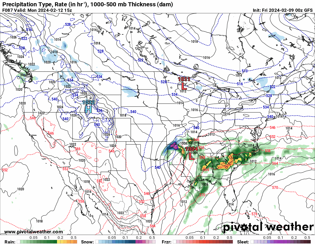
Cincinnati/NKY has just been added.

URGENT - WINTER WEATHER MESSAGE
National Weather Service Wilmington OH
340 PM EST Sun Feb 11 2024INZ075-080-KYZ089>099-OHZ077>079-120500-
/O.NEW.KILN.WW.Y.0005.240213T0000Z-240213T1200Z/
Ohio-Switzerland-Carroll-Gallatin-Boone-Kenton-Campbell-Owen-
Grant-Pendleton-Bracken-Robertson-Mason-Hamilton-Clermont-Brown-
Including the cities of Rising Sun, Vevay, Carrollton, Warsaw,
Florence, Burlington, Oakbrook, Covington, Erlanger,
Independence, Newport, Fort Thomas, Highland Heights, Bellevue,
Dayton, Alexandria, Owenton, Williamstown, Crittenden, Dry Ridge,
Falmouth, Butler, Augusta, Brooksville, Mount Olivet, Maysville,
Downtown Cincinnati, Milford, Summerside, Mount Carmel,
Mount Repose, Withamsville, Mulberry, Day Heights, Georgetown,
Mount Orab, Ripley, and Aberdeen
340 PM EST Sun Feb 11 2024...WINTER WEATHER ADVISORY IN EFFECT FROM 7 PM MONDAY TO 7 AM EST
TUESDAY...* WHAT...Snow expected. Total snow accumulations of 1 to 3
inches.* WHERE...Portions of southeast Indiana, northern Kentucky and
southwest Ohio.* WHEN...From 7 PM Monday to 7 AM EST Tuesday.
* IMPACTS...Plan on slippery road conditions. The hazardous
conditions could impact the morning commute.PRECAUTIONARY/PREPAREDNESS ACTIONS...
Slow down and use caution while traveling.
Additional information can be found at www.weather.gov/iln as
well as on our Facebook and Twitter pages.
-
Here's a better map.
-
9 minutes ago, sportsfan41 said:
Ha, I said that and then all of the models shifted south. Now it's a question of whether the cold air keeps the moisture to the south it seems. Wild @nWo
Ha Ha, I know how you feel. The 18z NAM now shows the snow going straight through southcentral and central Kentucky. This morning, it was showing snow along the Ohio River. I'm waiting for the 18z run of the GFS and ICON to be issued later today to see what it shows. They were both showing the heaviest snow north of Cincinnati. I am really interested to see what it shows. I want to see if it brings the snow back towards the south.
-
1 hour ago, sportsfan41 said:
I'm thinking this thing ends up taking the north of the Ohio River route that NKY usually misses out on snow from. It ends up being a dusting to an inch because we've seen this scenario so many times before.
-
INZ076>079-083-084-089>092-KYZ023>043-045>049-053>057-121000-
/O.NEW.KLMK.WW.Y.0004.240213T0000Z-240213T1200Z/
Orange-Washington IN-Scott IN-Jefferson IN-Dubois-Crawford-Perry-
Harrison IN-Floyd-Clark IN-Hancock-Breckinridge-Meade-Ohio-
Grayson-Hardin-Bullitt-Jefferson-Oldham-Trimble-Henry-Shelby-
Franklin-Scott KY-Harrison KY-Spencer-Anderson-Woodford-Fayette-
Bourbon-Nicholas-Nelson-Washington KY-Mercer-Jessamine-Clark KY-
Larue-Marion-Boyle-Garrard-Madison-
Including the cities of Paoli, Salem, Scottsburg, Madison,
Jasper, English, Tell City, Corydon, New Albany, Jeffersonville,
Lewisport, Hawesville, Hardinsburg, Brandenburg, Hartford,
Leitchfield, Elizabethtown, Shepherdsville, Louisville,
La Grange, Bedford, Milton, New Castle, Shelbyville, Frankfort,
Georgetown, Cynthiana, Taylorsville, Lawrenceburg, Versailles,
Lexington, Paris, Carlisle, Bardstown, Springfield, Harrodsburg,
Nicholasville, Winchester, Hodgenville, Lebanon, Danville,
Lancaster, and Richmond
322 PM EST Sun Feb 11 2024 /222 PM CST Sun Feb 11 2024/...WINTER WEATHER ADVISORY IN EFFECT FROM 7 PM EST /6 PM CST/
MONDAY TO 7 AM EST /6 AM CST/ TUESDAY...* WHAT...Rain is expected to quickly change over to wet snow
Monday evening. The snow could be heavy at times and
accumulations of up to 4 inches in some locations is possible.* WHERE...Portions of and south central Indiana and east
central, north central, northwest and south central Kentucky.* WHEN...From 7 PM EST /6 PM CST/ Monday to 7 AM EST /6 AM CST/
Tuesday.* IMPACTS...Plan on slippery road conditions. The hazardous
conditions could impact the Tuesday morning commute.* ADDITIONAL DETAILS...It is likely that a narrow band of heavy
snow will develop with this system. At this time, it is
impossible to determine where this band may set up. This
advisory highlights the areas of southern Indiana and central
Kentucky at most risk for impactful snow and subsequent changes
in the forecast may be required. Stay tuned for future forecast
updates.PRECAUTIONARY/PREPAREDNESS ACTIONS...
Slow down and use caution while traveling.
In Indiana, for Indiana Road Conditions please visit
http://pws.trafficwise.org In Kentucky, for Kentucky Road
Conditions please visit http://goky.ky.gov -
The heaviest snow accumulations have moved further north than yesterday, and there is a slight difference in the three models I am using this morning. The NAM is still coming in with the highest totals. This is the second call for possible snow accumulations. As I mentioned in my previous post, I expected the totals to lower slightly.
In the Cincinnati/NKY area, I am now projecting 2-4"; there is a chance for 6-8" just north of Cincinnati.
-
 1
1
-
-
25 minutes ago, sportsfan41 said:
Is that actually predicted snow accumulation or snow fall? Just wasn't surr how much would actually stick up here with the warm weather we had this week.
This is just a preliminary outlook. It will change and probably go down. With possible snowfall rates of 1/2 to 1" per hour, it wouldn't take long to start to accumulate, even with the warm weather. The 06z run of the GFS has risen to the high end of my prediction, but don't take just one individual run to make predictions. They can change between runs.
-
1
-
-
A clear picture of possible snow accumulations for late Monday into Tuesday morning is starting to take shape; temperatures cold enough for snow look to be confined north of I-64, and the bulk of the accumulations are expected to occur from Louisville to the Cincinnati/NKY area; south of this area will see mostly dusting of snow.
Kentucky will be lucky to escape this one, unless there is a significant shift in the prediction between now and the event. The low is still expected to strengthen and might become a Nor' Eastern for the New England region, but it is not expected to acquire intensity as quickly as previously believed.
I will go ahead and offer my first estimate for potential snow accumulations: 1-2" is anticipated for the Louisville region; the Cincinnati/NKY area appears to have the biggest accumulations; at this point, 4-8" are likely.
-
2 hours ago, PP1 said:
I must admit, I am not the best at reading your maps. In fact, without you to interpret, I would be studying the, for hours before reaching a conclusion. It appears though that if any part of Ky receives snow, it will be north of Lexington?
That's the way it looked this morning. There will more than likely be changes as we get closer.
1 hour ago, Voice of Reason said:Interesting how on the last map, the patterns over Canada do not move or change. Just sitting there. What is happening in that deep red area in Canada?
If you are talking about the 500mb Height Anomaly map. The red represents positive pressure or high-pressure areas. When you are under this area, temperatures are usually above average. The deeper the shade, the higher the pressure is and the more above-average your temperature could be. It's just the opposite under the blue areas.
-
1
-
-
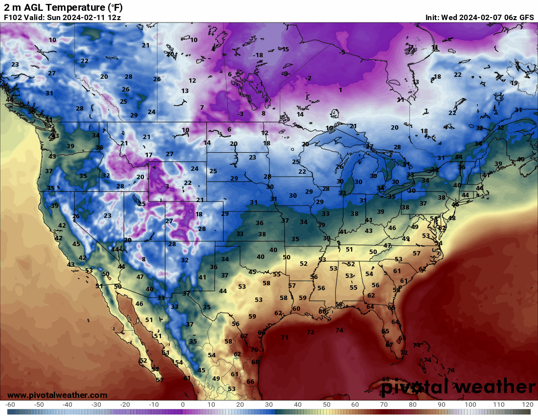
Updated forecast: A low-pressure system that is expected to bring precipitation on Monday is expected to track through southern and eastern Kentucky; the initial precipitation will be all rain. The only changes from my previous forecast are the small northward jog of the track and the amount of cold air that will wrap around the low. There is still some uncertainty in the forecast, but as the weekend progresses, we will have a better idea of what to expect. As of this post, not enough cold air will be pushed into Kentucky for everyone to see snow, but some could still get some accumulation.
-
Enjoy your weekend's springlike weather, as winter is expected to return to Kentucky early next week. Over the weekend, a weak area of low pressure is expected to move from the U.S. west coast towards Kentucky. As it approaches the Texas/New Mexico area, it will begin to strengthen and turn northeast late Sunday or early Monday morning. Precipitation will begin as rain, but as the low strengthens, arctic air from the Great Lakes area will wrap around it, turning it from rain to snow. Monday's lows will begin to drop, and by early Tuesday, temperatures will drop into the mid-20s. Any potential snow accumulation will depend on when the low moves toward the Texas/New Mexico area; it will begin to intensify and turn northeast late Sunday or early Monday morning. The precipitation will begin as rain, but as the low intensifies, arctic air will encircle the low from the Great Lakes area, changing the precipitation from rain to snow. Monday's lows will be in the low 20s by early Tuesday. Any potential snow accumulations will depend on timing and the low's precise track.
-
1
-
-
URGENT - WINTER WEATHER MESSAGE
National Weather Service Wilmington OH
308 AM EST Mon Jan 22 2024
INZ058-059-066-073>075-KYZ091>093-OHZ046-051>056-060>064-070>072-
077-078-221615-
/O.NEW.KILN.WW.Y.0004.240123T0100Z-240123T1700Z/
Fayette-Union-Franklin-Ripley-Dearborn-Ohio-Boone-Kenton-Campbell-
Delaware-Miami-Champaign-Clark-Madison-Licking-Preble-Montgomery-
Greene-Pickaway-Butler-Warren-Clinton-Hamilton-Clermont-
Including the cities of Connersville, Liberty,
West College Corner, Brookville, Batesville, Milan, Versailles,
Osgood, Bright, Lawrenceburg, Hidden Valley, Greendale, Aurora,
Dillsboro, Rising Sun, Florence, Burlington, Oakbrook, Covington,
Erlanger, Independence, Newport, Fort Thomas, Highland Heights,
Bellevue, Dayton, Alexandria, Delaware, Troy, Piqua, Tipp City,
Urbana, Springfield, London, West Jefferson, Plain City,
Downtown Columbus, Newark, Eaton, Camden, Downtown Dayton,
Kettering, Beavercreek, Fairborn, Xenia, Washington Court House,
Circleville, Hamilton, Middletown, Fairfield, Oxford, Mason,
Lebanon, Landen, Springboro, Franklin, Wilmington, Blanchester,
Downtown Cincinnati, Milford, Summerside, Mount Carmel,
Mount Repose, Withamsville, Mulberry, and Day Heights
308 AM EST Mon Jan 22 2024...WINTER WEATHER ADVISORY IN EFFECT FROM 8 PM THIS EVENING TO
NOON EST TUESDAY...* WHAT...Freezing rain expected. Total ice accumulations of up
to one tenth of an inch.* WHERE...Portions of east central and southeast Indiana,
northern Kentucky and central, southwest and west central Ohio.* WHEN...From 8 PM this evening to noon EST Tuesday.
* IMPACTS...Difficult travel conditions are possible. The
hazardous conditions could impact the morning commute.* ADDITIONAL DETAILS...Freezing rain will be possible with air
temperatures above freezing due to cold ground.PRECAUTIONARY/PREPAREDNESS ACTIONS...
Slow down and use caution while traveling. Prepare for possible
power outages.Additional information can be found at www.weather.gov/iln as
well as on our Facebook and Twitter pages.
-
35 minutes ago, theguru said:
As soon as I saw that you responded I knew it, high tech snow removal!
-
1
-
-
Yep, we got about another 3 inches last night here in Richmond. I used my cordless shovel.
-
KYZ050-058-059-069-111-114-116-191700-
/O.EXT.KJKL.WW.Y.0005.000000T0000Z-240119T2300Z/
Montgomery-Estill-Powell-Jackson-Lee-Owsley-Clay-
Including the cities of Camargo, Jeffersonville, Mount Sterling,
Irvine, Ravenna, Clay City, Stanton, McKee, Annville,
Beattyville, Booneville, and Manchester
429 AM EST Fri Jan 19 2024...WINTER WEATHER ADVISORY NOW IN EFFECT UNTIL 6 PM EST THIS
EVENING...* WHAT...Snow is expected. Snow accumulations during the early
morning and daytime hours will generally be an inch or less.* WHERE...Portions of east central and southeast Kentucky.
* WHEN...Until 6 PM EST this evening.
* IMPACTS...Plan on slippery road conditions. The hazardous
conditions could impact the morning or evening commute.PRECAUTIONARY/PREPAREDNESS ACTIONS...
Slow down and use caution while traveling.
The latest road conditions for Kentucky can be found by visiting
https://goky.ky.gov. -
INZ076>079-083-084-089>092-KYZ023>025-028>043-045>049-053>057-067-
192100-
/O.NEW.KLMK.WC.Y.0003.240120T0300Z-240120T1500Z/
/O.CON.KLMK.WW.Y.0003.000000T0000Z-240120T0000Z/
Orange-Washington IN-Scott IN-Jefferson IN-Dubois-Crawford-Perry-
Harrison IN-Floyd-Clark IN-Hancock-Breckinridge-Meade-Hardin-
Bullitt-Jefferson-Oldham-Trimble-Henry-Shelby-Franklin-Scott KY-
Harrison KY-Spencer-Anderson-Woodford-Fayette-Bourbon-Nicholas-
Nelson-Washington KY-Mercer-Jessamine-Clark KY-Larue-Marion-Boyle-
Garrard-Madison-Lincoln-
Including the cities of Paoli, Salem, Scottsburg, Madison,
Jasper, English, Tell City, Corydon, New Albany, Jeffersonville,
Lewisport, Hawesville, Hardinsburg, Brandenburg, Elizabethtown,
Shepherdsville, Louisville, La Grange, Bedford, Milton,
New Castle, Shelbyville, Frankfort, Georgetown, Cynthiana,
Taylorsville, Lawrenceburg, Versailles, Lexington, Paris,
Carlisle, Bardstown, Springfield, Harrodsburg, Nicholasville,
Winchester, Hodgenville, Lebanon, Danville, Lancaster, Richmond,
and Stanford
340 AM EST Fri Jan 19 2024 /240 AM CST Fri Jan 19 2024/...WINTER WEATHER ADVISORY REMAINS IN EFFECT UNTIL 7 PM EST /6 PM
CST/ THIS EVENING...
...WIND CHILL ADVISORY IN EFFECT FROM 10 PM EST /9 PM CST/ THIS
EVENING TO 10 AM EST /9 AM CST/ SATURDAY...* WHAT...Another round of snow is expected this morning, which
could cause negative travel impacts for the morning commute.
Additional snowfall amounts between 0.3-1.0" will be possible
after 7 AM EST this morning across southern Indiana and north
central Kentucky. For the Wind Chill Advisory, very cold wind
chills expected tonight and into Saturday morning. Wind chills
between -5 and -15 degrees possible.* WHERE...Southern Indiana and north central Kentucky.
* WHEN...From noon EST /11 AM CST/ Thursday to 7 PM EST /6 PM CST/
Friday. Wind Chill Advisory in effect from 10 PM EST / 9 PM CST
this evening to 10 AM EST / 9 AM CST Saturday.* IMPACTS...Plan on slippery road conditions. The hazardous
conditions could result in negative travel impacts for today.* ADDITIONAL DETAILS...Untreated secondary roads and bridges could
be especially slick.PRECAUTIONARY/PREPAREDNESS ACTIONS...
Slow down and use caution while traveling.
In Indiana, for Indiana Road Conditions please visit
http://pws.trafficwise.org In Kentucky, for Kentucky Road
Conditions please visit http://goky.ky.govA Wind Chill Advisory means that very cold air and strong winds
will combine to generate low wind chills. This will result in
frost bite and lead to hypothermia if precautions are not taken.
If you must venture outdoors...make sure you wear a hat and gloves.
KYZ026-027-061>066-070>078-081-082-192100-
/O.NEW.KLMK.WC.Y.0003.240120T0300Z-240120T1500Z/
/O.CON.KLMK.WW.Y.0003.000000T0000Z-240120T0000Z/
Ohio-Grayson-Butler-Edmonson-Hart-Green-Taylor-Casey-Logan-Warren-
Simpson-Allen-Barren-Monroe-Metcalfe-Adair-Russell-Cumberland-
Clinton-
Including the cities of Hartford, Leitchfield, Morgantown,
Brownsville, Horse Cave, Greensburg, Campbellsville, Liberty,
Russellville, Bowling Green, Franklin, Providence, Scottsville,
Glasgow, Tompkinsville, Edmonton, Columbia, Jamestown,
Burkesville, and Albany
340 AM EST Fri Jan 19 2024 /240 AM CST Fri Jan 19 2024/
...WINTER WEATHER ADVISORY REMAINS IN EFFECT UNTIL 7 PM EST /6 PM
CST/ THIS EVENING...
...WIND CHILL ADVISORY IN EFFECT FROM 10 PM EST /9 PM CST/ THIS
EVENING TO 10 AM EST /9 AM CST/ SATURDAY...
* WHAT...A brief period of light snow this morning could put down
light accumulations. Road conditions may be hazardous, which
could cause negative travel impacts for the morning commute.
For the Wind Chill Advisory, very cold wind chills expected
tonight and into Saturday morning. Wind chills between -5 and
-15 degrees possible.
* WHERE...The south central Kentucky.
* WHEN...From noon EST /11 AM CST/ Thursday to 7 PM EST /6 PM CST/
Friday. Wind Chill Advisory in effect from 10 PM EST / 9 PM CST
this evening to 10 AM EST / 9 AM CST Saturday.
* IMPACTS...Plan on slippery road conditions. The hazardous
conditions could result in negative travel impacts for today.
* ADDITIONAL DETAILS...Untreated secondary roads and bridges could
be especially slick.
PRECAUTIONARY/PREPAREDNESS ACTIONS...
Slow down and use caution while traveling.
For Kentucky Road Conditions please visit http://goky.ky.gov
A Wind Chill Advisory means that very cold air and strong winds
will combine to generate low wind chills. This will result in
frost bite and lead to hypothermia if precautions are not taken.
If you must venture outdoors...make sure you wear a hat and gloves.
-
INZ076>079-083-084-089>092-KYZ023>025-028>043-045>049-053>057-067-
192100-
/O.NEW.KLMK.WC.Y.0003.240120T0300Z-240120T1500Z/
/O.CON.KLMK.WW.Y.0003.000000T0000Z-240120T0000Z/
Orange-Washington IN-Scott IN-Jefferson IN-Dubois-Crawford-Perry-
Harrison IN-Floyd-Clark IN-Hancock-Breckinridge-Meade-Hardin-
Bullitt-Jefferson-Oldham-Trimble-Henry-Shelby-Franklin-Scott KY-
Harrison KY-Spencer-Anderson-Woodford-Fayette-Bourbon-Nicholas-
Nelson-Washington KY-Mercer-Jessamine-Clark KY-Larue-Marion-Boyle-
Garrard-Madison-Lincoln-
Including the cities of Paoli, Salem, Scottsburg, Madison,
Jasper, English, Tell City, Corydon, New Albany, Jeffersonville,
Lewisport, Hawesville, Hardinsburg, Brandenburg, Elizabethtown,
Shepherdsville, Louisville, La Grange, Bedford, Milton,
New Castle, Shelbyville, Frankfort, Georgetown, Cynthiana,
Taylorsville, Lawrenceburg, Versailles, Lexington, Paris,
Carlisle, Bardstown, Springfield, Harrodsburg, Nicholasville,
Winchester, Hodgenville, Lebanon, Danville, Lancaster, Richmond,
and Stanford
340 AM EST Fri Jan 19 2024 /240 AM CST Fri Jan 19 2024/
...WINTER WEATHER ADVISORY REMAINS IN EFFECT UNTIL 7 PM EST /6 PM
CST/ THIS EVENING...
...WIND CHILL ADVISORY IN EFFECT FROM 10 PM EST /9 PM CST/ THIS
EVENING TO 10 AM EST /9 AM CST/ SATURDAY...
* WHAT...Another round of snow is expected this morning, which
could cause negative travel impacts for the morning commute.
Additional snowfall amounts between 0.3-1.0" will be possible
after 7 AM EST this morning across southern Indiana and north
central Kentucky. For the Wind Chill Advisory, very cold wind
chills expected tonight and into Saturday morning. Wind chills
between -5 and -15 degrees possible.
* WHERE...Southern Indiana and north central Kentucky.
* WHEN...From noon EST /11 AM CST/ Thursday to 7 PM EST /6 PM CST/
Friday. Wind Chill Advisory in effect from 10 PM EST / 9 PM CST
this evening to 10 AM EST / 9 AM CST Saturday.
* IMPACTS...Plan on slippery road conditions. The hazardous
conditions could result in negative travel impacts for today.
* ADDITIONAL DETAILS...Untreated secondary roads and bridges could
be especially slick.
PRECAUTIONARY/PREPAREDNESS ACTIONS...
Slow down and use caution while traveling.
In Indiana, for Indiana Road Conditions please visit
http://pws.trafficwise.org In Kentucky, for Kentucky Road
Conditions please visit http://goky.ky.gov
A Wind Chill Advisory means that very cold air and strong winds
will combine to generate low wind chills. This will result in
frost bite and lead to hypothermia if precautions are not taken.
If you must venture outdoors...make sure you wear a hat and gloves.
-
-
URGENT - WINTER WEATHER MESSAGE
National Weather Service Jackson KY
227 PM EST Wed Jan 17 2024

KYZ044-050>052-058>060-068-069-079-080-083>088-104-106>120-180330-
/O.NEW.KJKL.WW.Y.0005.240119T0000Z-240120T1200Z/
Fleming-Montgomery-Bath-Rowan-Estill-Powell-Menifee-Rockcastle-
Jackson-Pulaski-Laurel-Wayne-McCreary-Whitley-Knox-Bell-Harlan-
Elliott-Morgan-Johnson-Wolfe-Magoffin-Floyd-Lee-Breathitt-Knott-
Owsley-Perry-Clay-Leslie-Letcher-Martin-Pike-
Including the cities of Flemingsburg, Camargo, Jeffersonville,
Mount Sterling, Owingsville, Morehead, Irvine, Ravenna,
Clay City, Stanton, Frenchburg, Brodhead, Mount Vernon, McKee,
Annville, Burnside, Somerset, London, Monticello, Stearns,
Whitley City, Corbin, Williamsburg, Barbourville, Middlesboro,
Pineville, Cumberland, Harlan, Sandy Hook, West Liberty,
Paintsville, Campton, Salyersville, Prestonsburg, Wheelwright,
Beattyville, Jackson, Hindman, Pippa Passes, Booneville, Hazard,
Manchester, Hyden, Jenkins, Whitesburg, Inez, Coal Run,
Elkhorn City, Pikeville, and South Williamson
227 PM EST Wed Jan 17 2024

...WINTER WEATHER ADVISORY IN EFFECT FROM 7 PM THURSDAY TO 7 AM
EST SATURDAY...

* WHAT...Snow expected from the Mountain Parkway north, with mixed
  precipitation south of the Mountain Parkway. Total snow
  accumulations of 1 to 4 inches and ice accumulations of a light
  glaze are expected.

* WHERE...Portions of east central, northeast, south central and
  southeast Kentucky.

* WHEN...From 7 PM Thursday to 7 AM EST Saturday.

* IMPACTS...Plan on slippery road conditions. The hazardous
  conditions could impact the morning or evening commute.

* ADDITIONAL DETAILS...All snow is expected from the Mountain
  Parkway north. South of the Mountain Parkway, precipitation may
  begin as a period of mixed precipitation, with snow, sleet, and
  freezing rain possible Thursday evening. Precipitation should
  change to all snow by Friday morning. Note that even a cold
  rain falling on frozen surfaces will result in ice concerns for
  locations mainly along and south of the Hal Rogers Parkway.


PRECAUTIONARY/PREPAREDNESS ACTIONS...

Slow down and use caution while traveling.

The latest road conditions for Kentucky can be found by visiting
https://goky.ky.gov.
-
URGENT - WINTER WEATHER MESSAGE
National Weather Service Paducah KY
156 PM CST Wed Jan 17 2024

INZ087-088-KYZ001>022-MOZ112-114-181000-
/O.NEW.KPAH.WW.Y.0002.240118T1600Z-240119T1500Z/
Warrick-Spencer-Fulton-Hickman-Carlisle-Ballard-McCracken-Graves-
Livingston-Marshall-Calloway-Crittenden-Lyon-Trigg-Caldwell-
Union KY-Webster-Hopkins-Christian-Henderson-Daviess-McLean-
Muhlenberg-Todd-Mississippi-New Madrid-
Including the cities of Boonville, Rockport, Hickman, Clinton,
Bardwell, Wickliffe, Paducah, Mayfield, Smithland, Benton,
Murray, Marion, Eddyville, Cadiz, Princeton, Morganfield, Dixon,
Madisonville, Hopkinsville, Henderson, Owensboro, Calhoun,
Greenville, Elkton, Charleston, and New Madrid
156 PM CST Wed Jan 17 2024

...WINTER WEATHER ADVISORY IN EFFECT FROM 10 AM THURSDAY TO 9 AM
CST FRIDAY...

* WHAT...A wintry mix of light freezing rain and snow is expected
  on late Thursday morning into Thursday afternoon, ending as a
  short period of freezing drizzle Thursday evening. A glaze of
  ice and minor snow accumulation will be possible, especially in
  portions of western Kentucky.

* WHERE...Portions of southwest Indiana, western Kentucky and
  southeast Missouri.

* WHEN...From 10 AM Thursday to 9 AM CST Friday.

* IMPACTS...Plan on slippery road conditions. The hazardous
  conditions will likely impact the Thursday evening commute and
  may also impact the Friday morning commute.

PRECAUTIONARY/PREPAREDNESS ACTIONS...

Slow down and use caution while traveling.

The latest road conditions for the state you are calling from can
be obtained by calling 5 1 1.
-
Briefing slides I received from the National Weather Service-Louisville office.
-
KYZ044-050>052-058>060-068-069-079-080-083>088-104-106>120-180330-
/O.NEW.KJKL.WW.Y.0005.240119T0000Z-240120T1200Z/
Fleming-Montgomery-Bath-Rowan-Estill-Powell-Menifee-Rockcastle-
Jackson-Pulaski-Laurel-Wayne-McCreary-Whitley-Knox-Bell-Harlan-
Elliott-Morgan-Johnson-Wolfe-Magoffin-Floyd-Lee-Breathitt-Knott-
Owsley-Perry-Clay-Leslie-Letcher-Martin-Pike-
Including the cities of Flemingsburg, Camargo, Jeffersonville,
Mount Sterling, Owingsville, Morehead, Irvine, Ravenna,
Clay City, Stanton, Frenchburg, Brodhead, Mount Vernon, McKee,
Annville, Burnside, Somerset, London, Monticello, Stearns,
Whitley City, Corbin, Williamsburg, Barbourville, Middlesboro,
Pineville, Cumberland, Harlan, Sandy Hook, West Liberty,
Paintsville, Campton, Salyersville, Prestonsburg, Wheelwright,
Beattyville, Jackson, Hindman, Pippa Passes, Booneville, Hazard,
Manchester, Hyden, Jenkins, Whitesburg, Inez, Coal Run,
Elkhorn City, Pikeville, and South Williamson
227 PM EST Wed Jan 17 2024
...WINTER WEATHER ADVISORY IN EFFECT FROM 7 PM THURSDAY TO 7 AM
EST SATURDAY...
* WHAT...Snow expected from the Mountain Parkway north, with mixed
precipitation south of the Mountain Parkway. Total snow
accumulations of 1 to 4 inches and ice accumulations of a light
glaze are expected.
* WHERE...Portions of east central, northeast, south central and
southeast Kentucky.
* WHEN...From 7 PM Thursday to 7 AM EST Saturday.
* IMPACTS...Plan on slippery road conditions. The hazardous
conditions could impact the morning or evening commute.
* ADDITIONAL DETAILS...All snow is expected from the Mountain
Parkway north. South of the Mountain Parkway, precipitation may
begin as a period of mixed precipitation, with snow, sleet, and
freezing rain possible Thursday evening. Precipitation should
change to all snow by Friday morning. Note that even a cold
rain falling on frozen surfaces will result in ice concerns for
locations mainly along and south of the Hal Rogers Parkway.
PRECAUTIONARY/PREPAREDNESS ACTIONS...
Slow down and use caution while traveling.
The latest road conditions for Kentucky can be found by visiting
https://goky.ky.gov. -
KYZ026-027-061>066-070>078-081-082-181000-
/O.NEW.KLMK.WW.Y.0003.240118T1700Z-240120T0000Z/
Ohio-Grayson-Butler-Edmonson-Hart-Green-Taylor-Casey-Logan-Warren-
Simpson-Allen-Barren-Monroe-Metcalfe-Adair-Russell-Cumberland-
Clinton-
Including the cities of Hartford, Leitchfield, Morgantown,
Brownsville, Horse Cave, Greensburg, Campbellsville, Liberty,
Russellville, Bowling Green, Franklin, Providence, Scottsville,
Glasgow, Tompkinsville, Edmonton, Columbia, Jamestown,
Burkesville, and Albany
230 PM EST Wed Jan 17 2024 /130 PM CST Wed Jan 17 2024/
...WINTER WEATHER ADVISORY IN EFFECT FROM NOON EST /11 AM CST/
THURSDAY TO 7 PM EST /6 PM CST/ FRIDAY...
* WHAT...A wintry mix of snow, freezing rain, and plain rain is
expected to develop across the region Thursday afternoon. Areas
of freezing drizzle are expected Thursday evening followed by a
period of light snow late Thursday night and into Friday
morning. Total snow accumulations of 1 to 1.5 inches will be
possible along with less than a tenth of an inch of ice.
* WHERE...The southern half of Kentucky.
* WHEN...From noon EST /11 AM CST/ Thursday to 7 PM EST /6 PM
CST/ Friday.
* IMPACTS...Plan on slippery road conditions. The hazardous
conditions could impact the Thursday afternoon commute and will
likely result in negative travel impacts Thursday night and
Friday morning.
PRECAUTIONARY/PREPAREDNESS ACTIONS...
Slow down and use caution while traveling.
For Kentucky Road Conditions please visit http://goky.ky.gov -
NZ076>079-083-084-089>092-KYZ023>025-028>043-045>049-053>057-067-
181000-
/O.NEW.KLMK.WW.Y.0003.240118T1700Z-240120T0000Z/
Orange-Washington IN-Scott IN-Jefferson IN-Dubois-Crawford-Perry-
Harrison IN-Floyd-Clark IN-Hancock-Breckinridge-Meade-Hardin-
Bullitt-Jefferson-Oldham-Trimble-Henry-Shelby-Franklin-Scott KY-
Harrison KY-Spencer-Anderson-Woodford-Fayette-Bourbon-Nicholas-
Nelson-Washington KY-Mercer-Jessamine-Clark KY-Larue-Marion-Boyle-
Garrard-Madison-Lincoln-
Including the cities of Paoli, Salem, Scottsburg, Madison,
Jasper, English, Tell City, Corydon, New Albany, Jeffersonville,
Lewisport, Hawesville, Hardinsburg, Brandenburg, Elizabethtown,
Shepherdsville, Louisville, La Grange, Bedford, Milton,
New Castle, Shelbyville, Frankfort, Georgetown, Cynthiana,
Taylorsville, Lawrenceburg, Versailles, Lexington, Paris,
Carlisle, Bardstown, Springfield, Harrodsburg, Nicholasville,
Winchester, Hodgenville, Lebanon, Danville, Lancaster, Richmond,
and Stanford
230 PM EST Wed Jan 17 2024 /130 PM CST Wed Jan 17 2024/
...WINTER WEATHER ADVISORY IN EFFECT FROM NOON EST /11 AM CST/
THURSDAY TO 7 PM EST /6 PM CST/ FRIDAY...
* WHAT...An initial wintry mix of snow and some freezing rain is
expected Thursday afternoon with a short period of freezing
drizzle Thursday evening. Widespread light to moderate snow is
expected late Thursday night and through the day on Friday.
Total snowfall accumulations of 1 to 3 inches with a small glaze
of icing will be possible across southern Indiana and northern
portions of Kentucky.
* WHERE...Southern Indiana and the northern half of Kentucky.
* WHEN...From noon EST /11 AM CST/ Thursday to 7 PM EST /6 PM
CST/ Friday.
* IMPACTS...Plan on slippery road conditions. The hazardous
conditions could impact the Thursday evening commute and will
likely result in negative travel impacts Thursday night and
through the day on Friday.
PRECAUTIONARY/PREPAREDNESS ACTIONS...
Slow down and use caution while traveling.
In Indiana, for Indiana Road Conditions please visit
http://pws.trafficwise.org In Kentucky, for Kentucky Road
Conditions please visit http://goky.ky.gov
.png.4f302cdf3185f3041783d8a5ab3fe404.png)


.png.3c03c8949e27cd5dd2b7dc0ada63156d.png)
.png.bd7ce4b10f7597df78209e10d31f5340.png)


.png.94a662067b793b21cccbfc89c32b3a3a.png)


Winter to return to Kentucky
in Weather
Posted
Without a doubt, the snow field that was there this morning has narrowed, and the track has moved south. The piling snow on both the north and south sides of the track will have a quick cutoff. Either the north or south side of the track may have dusting to 1"; generally speaking, 2-4" will be feasible.