.png.ffa34568722b20f38e3c3ecfcb9a2cd2.png)

.jpg.dff87640c6ed93f4bdf8eebdf96f5dec.jpg)
nWo
-
Posts
25,628 -
Joined
-
Last visited
-
Days Won
5
Posts posted by nWo
-
-
My daughter was in Nashville about an hour ago. She asked, should she leave and go home? I told her yes. Glad she did.
-
Particularly Dangerous Tornado warning.
PDS Tornado Warning now for Downtown Nashville. THIS IS A LIFE THREATENING, EXTREMELY DANGEROUS SITUATION!
-
The area has just been expanded to I-75, including Somerset and Mt Vernon.
 t
t
-
 1
1
-
-
My daughter was returning from Nashville and passed by this exit and she said she saw people standing outside the hotels. No word on any injuries yet.
-
Also, there was some damage to Motel 8 hotel near Exit 22.
-
I just got a call from my son that the LaQuinta Inn on Scottsville Rd. near I-65 exit 22 lost it's roof. This is about 3-5 miles, if that far from my son's house. We take this exit to go to my son's house.
-
The threat to Bowling Green has passed for now. More storms may be forming to the southeast of Russellville. For now, it appears to be mainly heavy rain and high winds.
-
5 minutes ago, theguru said:
You are talking the talk Deuce, watch out @nWo!
Any mention of injuries or worse?
No worries from me.
-
 1
1
-
-
video from twitter
-
The Tornado Watch area has just been expanded eastward.
KYC001-021-045-053-057-137-155-207-217-100500-
/O.NEW.KLMK.TO.A.0715.231209T2127Z-231210T0500Z/THE NATIONAL WEATHER SERVICE HAS ISSUED TORNADO WATCH 715 IN
EFFECT UNTIL MIDNIGHT EST /11 PM CST/ TONIGHT FOR THE FOLLOWING
AREASIN KENTUCKY THIS WATCH INCLUDES 9 COUNTIES
IN CENTRAL KENTUCKY
BOYLE CASEY LINCOLN
MARION TAYLORIN SOUTH CENTRAL KENTUCKY
ADAIR CLINTON CUMBERLAND
RUSSELLTHIS INCLUDES THE CITIES OF ALBANY, AMANDAVILLE, ARGYLE,
BURKESVILLE, CAMPBELLSVILLE, CANE VALLEY, CLEMENTSVILLE, COBURG,
COLUMBIA, CREELSBORO, CROCUS, CUMBERLAND CITY, DANVILLE, DUBRE,
DUNNVILLE, ELK HORN, ELLA, GLENS FORK, GRADYVILLE, HOBSON, JABEZ,
JAMESTOWN, LEBANON, LIBERTY, MARROWBONE, MIDDLEBURG, MIDDLETOWN,
MINTONVILLE, NEW MARKET, OLGA, PEYTONSBURG, ROWLAND,
RUSSELL SPRINGS, SALEM, SALOMA, STANFORD, STATIC, WINDSOR,
AND YUMA.-
1
-
-
It appears that the radar-indicated rotation is now past Bowling Green and is now just southeast of Smith's Grove.
-
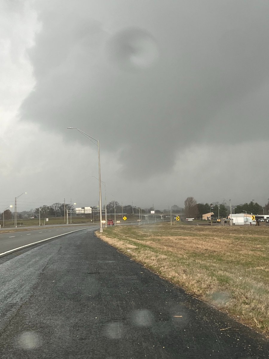
Wall cloud and funnel south side of Bowling Green. Looks like the intersection of 31w and I-165.
-
 1
1
-
-
I just heard from my son. This is taking just about the same track as the December 2021 tornado.
-
The rotation of this storm has widened this is a sign of its weakening but could restrengthen at any time.
-
1
-
-
Just got the latest from NWS-Louisville. This is a long-track tornado. Everyone in the path of this tornado should take this very seriously.
-
URGENT - IMMEDIATE BROADCAST REQUESTED
Tornado Watch Number 714
NWS Storm Prediction Center Norman OK
1135 AM CST Sat Dec 9 2023The NWS Storm Prediction Center has issued a
* Tornado Watch for portions of
Southeast Arkansas
Western and Central Kentucky
Northern Mississippi
Western and Middle Tennessee* Effective this Saturday morning and evening from 1135 AM until
700 PM CST.* Primary threats include...
A few tornadoes likely
Scattered damaging wind gusts to 70 mph possible
Isolated large hail events to 1 inch in diameter possibleSUMMARY...Strong to severe thunderstorms will continue to develop
and increase through early afternoon near an eastward-moving cold
front, with additional/more isolated development also possible ahead
of it later this afternoon. Increasingly low-level moisture and
strong shear will support the potential for severe storms including
a few tornadoes.The tornado watch area is approximately along and 85 statute miles
east and west of a line from 30 miles north of Bowling Green KY to 5
miles east southeast of Monticello AR. For a complete depiction of
the watch see the associated watch outline update (WOUS64 KWNS
WOU4).PRECAUTIONARY/PREPAREDNESS ACTIONS...
REMEMBER...A Tornado Watch means conditions are favorable for
tornadoes and severe thunderstorms in and close to the watch
area. Persons in these areas should be on the lookout for
threatening weather conditions and listen for later statements
and possible warnings. -
A few tornadoes, damaging to severe thunderstorm gusts, and isolated severe hail are possible today and tonight from portions of the Ohio Valley southward to the central Gulf Coast. A few tornadoes, damaging to severe thunderstorm gusts, and isolated severe hail are possible today and tonight from portions of the Ohio Valley southward to the central Gulf Coast.
-
The severe threat has increased since this morning. I expect the level 2 Slight Risk area to be expanded to include Louisville and points east to about I-75. The main threat window for possible severe storms that could produce tornadoes is 4–10 p.m. EST. The severe storm threat should exit eastern Kentucky early Sunday morning.
-
I forgot to add these maps to the first post.
-
-
The latest outlook from the Storm Prediction Center has extended a level 2 Slight Risk Area into southcentral Kentucky. This area is centered around Bowling Green. In advance of a cold front, conditions will be in place across parts of Texas and Louisiana Saturday morning and stream northward into parts of the Southeast and TN Valley through the day, which could allow severe storms to form. Surface-based thunderstorms are expected to increase in coverage on Saturday afternoon. Large hail will be possible with any sustained supercells. Also, increasing low-level shear will be sufficient to support a tornado threat with any supercells that can be sustained from late afternoon into the evening, especially if stronger squall lines develop. Otherwise, damaging wind and possibly embedded, brief tornadoes may become the primary threat on Saturday night as storms move eastward, with a gradual weakening trend expected due to diminishing buoyancy.
-
1
-
-
The level 1 Marginal Risk Area has been expanded to include much of Kentucky west of I-75. Scattered severe thunderstorms with damaging winds, hail, and a low-level tornado threat will be possible Saturday afternoon and evening. I will post an update later and possibly go into a severe weather alert day.
-
The threat level for portions of WKY has been raised to a level 1 Marginal Risk Area for Saturday afternoon into the evening hours.
-
Strong storms are possible on Saturday, mainly for western Kentucky. With a highly amplified/positive-tilt upper trough over the central states, thunderstorm development will become widespread along and ahead of the front by afternoon. This trough will have strong southwesterly winds, bringing more warm, humid air from the south into Kentucky. As of now, dew points are forecast to rise into the 50s. If this trend continues, we could see dew points rise into the 60s. Air temperatures will also rise into the mid-to-upper 60s. As of now, in their day 4 outlook, the Storm Prediction Center omits WKY in the Slight Chance area, but I would not be surprised if that changes shortly. The storm segments possibly appear to be damaging winds, hail, and a low-end tornado threat. Updates will be posted soon.


PDS Tornado Warning for downtown Nashville.
in Weather
Posted
Tornado Warning
TNC021-037-043-147-092245-
/O.NEW.KOHX.TO.W.0034.231209T2209Z-231209T2245Z/
BULLETIN - EAS ACTIVATION REQUESTED
Tornado Warning
National Weather Service Nashville TN
409 PM CST Sat Dec 9 2023
The National Weather Service in Nashville has issued a
* Tornado Warning for...
Central Davidson County in Middle Tennessee...
East central Dickson County in Middle Tennessee...
Central Cheatham County in Middle Tennessee...
South central Robertson County in Middle Tennessee...
* Until 445 PM CST.
* At 409 PM CST, a confirmed large and extremely dangerous tornado
was located near White Bluff, or 8 miles southwest of Ashland City,
moving east at 40 mph.
This is a PARTICULARLY DANGEROUS SITUATION. TAKE COVER NOW!
HAZARD...Damaging tornado.
SOURCE...Radar confirmed tornado.
IMPACT...You are in a life-threatening situation. Flying debris
may be deadly to those caught without shelter. Mobile
homes will be destroyed. Considerable damage to homes,
businesses, and vehicles is likely and complete
destruction is possible.
* The tornado will be near...
Ashland City around 415 PM CST.
Joelton around 430 PM CST.
Other locations impacted by this tornadic thunderstorm include Beaman
Park, Whites Creek, and Bells Bend.
This includes the following highways...
Interstate 40 between mile markers 201 and 211.
Interstate 65 between mile markers 85 and 97.
Interstate 24 between mile markers 30 and 49.
PRECAUTIONARY/PREPAREDNESS ACTIONS...
To repeat, a large, extremely dangerous and potentially deadly
tornado is on the ground. To protect your life, TAKE COVER NOW! Move
to a basement or an interior room on the lowest floor of a sturdy
building. Avoid windows. If you are outdoors, in a mobile home, or in
a vehicle, move to the closest substantial shelter and protect
yourself from flying debris.