.png.ffa34568722b20f38e3c3ecfcb9a2cd2.png)
Search the Community
Showing results for tags 'weather'.
-
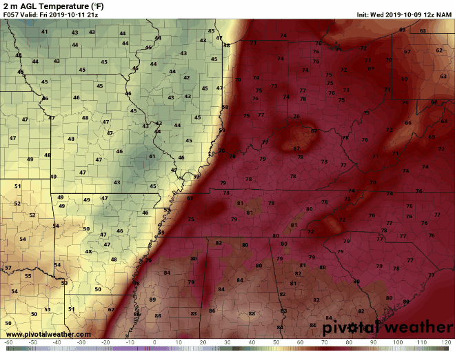
It appears that those who will be attending this upcoming Friday's games will have to deal with some wet conditions. Rain will be falling most of the day on Friday before it moves out of Kentucky late Friday night or early Saturday morning. The following Euro Ohio Valley Radar is from 1 am to 7 pm EST. As of now the heaviest rain accumulations looks to be in western and portions of southcentral Kentucky. Those in those areas are looking to get around an inch maybe a little more by 7 PM EST Friday evening. Most of the rest of the state it looking at between .5-.8 inches. This is just in a 24 hour period ending at 7 PM. The temperature looks to range from the low 40s mainly north of I-64 to the mid to upper 40s south of I-64. This is around the start of the games. Check back for updates tomorrow.

-
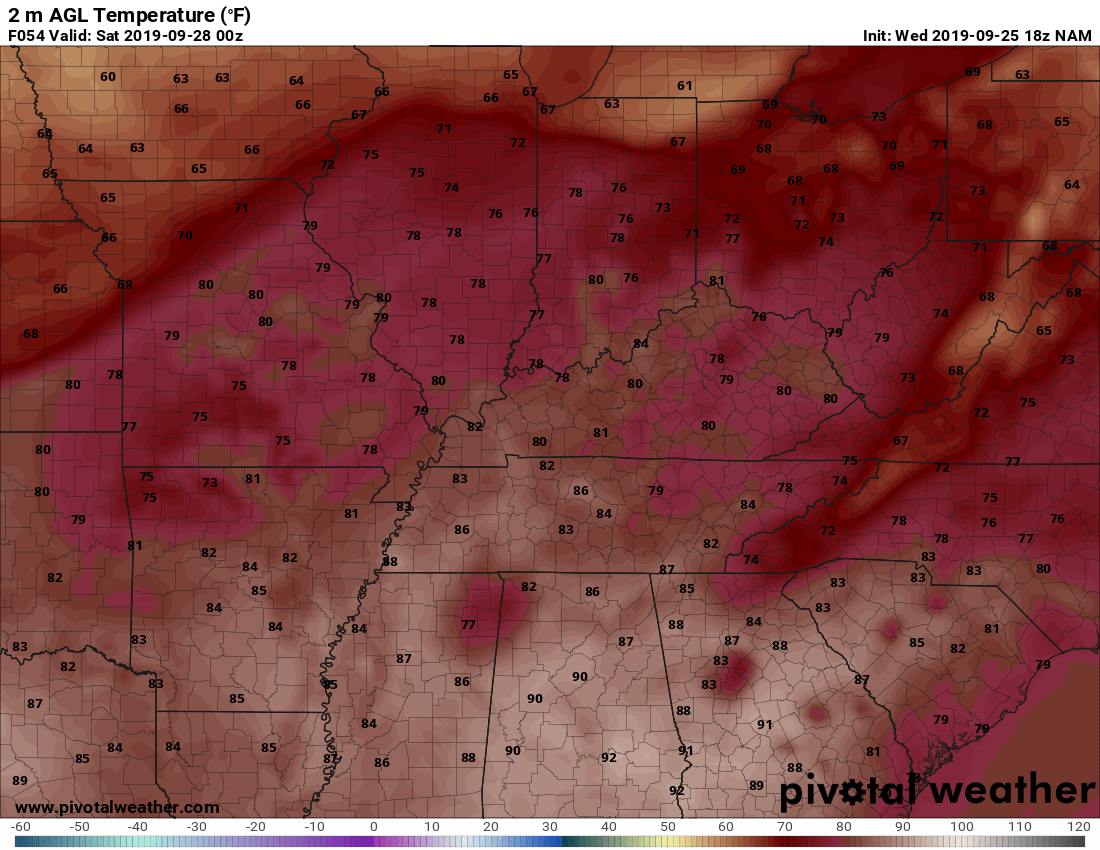
For Thursday's game look for cloudy skies mainly east of I-65. For now little or no chance for rain. Temps should range from the mid to upper 60s to low 70s. Those attending Friday night's games can look for some fall weather coming into Kentucky. Especially in western Kentucky. A cold front should pass through late Friday evening. Temperatures could fall into the mid-40s along with a chance for some showers by the end of some of the games. Temperatures should start in the mid-70s but fall as the front transverse across Kentucky. Everyone can see the cold front well on the temperature map simulation. The maps end at 11 pm EDT Friday night. The map should be around the I-65 corridor then.
-
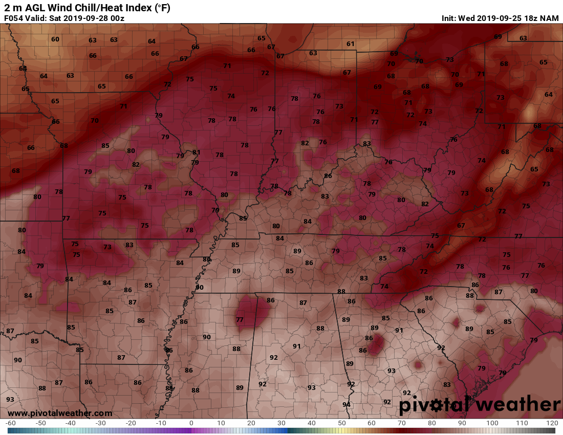
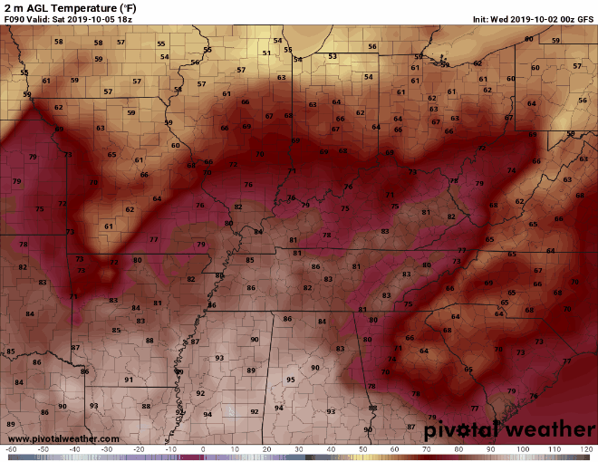
Look for temperatures to range from the high 70s to low 80s with for now little or no chance for precipitation. The heat index looks to be from the high 70s to low 80s mainly from around the I-75 corridor eastward. West of that look for heat indices in the low to mid-80s.
-
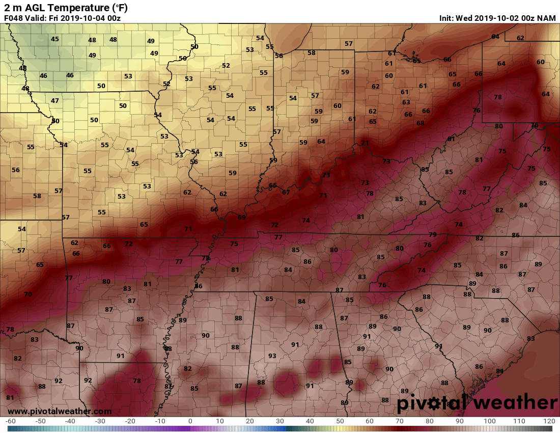
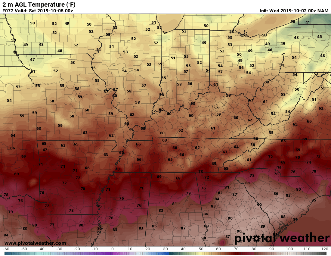
First for the games on Thursday look for temperatures to range from the high 60s to the low to mid-70s for most of Kentucky. Southeast Kentucky could see temperatures in the low to mid 80 range. For now, there seems to be little to no chance for rain for any of the games this weekend. For Friday's game, it appears that we will finally have temperatures that are close to being normal for this time of year. Most of Kentucky will see the temperatures range in the low 60s. There are some who could see temperatures in the high 50s. For the two games on Saturday. Look for mid to upper 70s during the afternoon and the temperatures falling to around the mid to upper 60s for.
-
There is a chance for some scattered showers during the afternoon on Friday. For now mainly in the northern Kentucky and Bowling Green areas. Of course, the exact positioning of the showers is impossible to know. The precipitation should be over by the start of the games. Maybe some scattered showers in and around the Bowling Green area. Temperatures should range from the high 60s to low 70s. Western Kentucky could reach the high 70s. I will post an update tomorrow.
-
750 PM EDT Mon Apr 13 2020 /650 PM CDT Mon Apr 13 2020/ ...FREEZE WATCH IN EFFECT FROM LATE TUESDAY NIGHT THROUGH WEDNESDAY MORNING... The National Weather Service in Louisville has issued a Freeze Watch, which is in effect from late Tuesday night through Wednesday morning. * TEMPERATURE...Lows Tuesday night and Wednesday morning are expected to drop into the mid-upper 20s. * IMPACTS...Widespread frost and freeze conditions could kill crops, other sensitive vegetation and possibly damage unprotected outdoor plumbing. PRECAUTIONARY/PREPAREDNESS ACTIONS... Take steps now to protect tender plants from the cold. To prevent freezing and possible bursting of outdoor water pipes they should be wrapped, drained, or allowed to drip slowly. Those that have in-ground sprinkler systems should drain them and cover above- ground pipes to protect them from freezing.
-
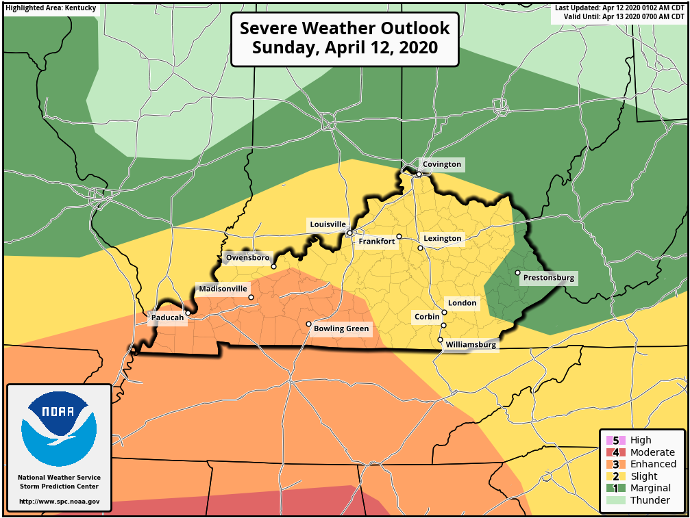
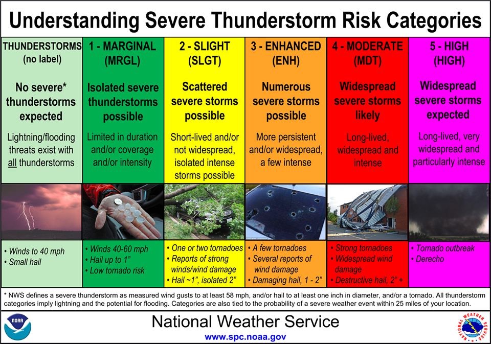
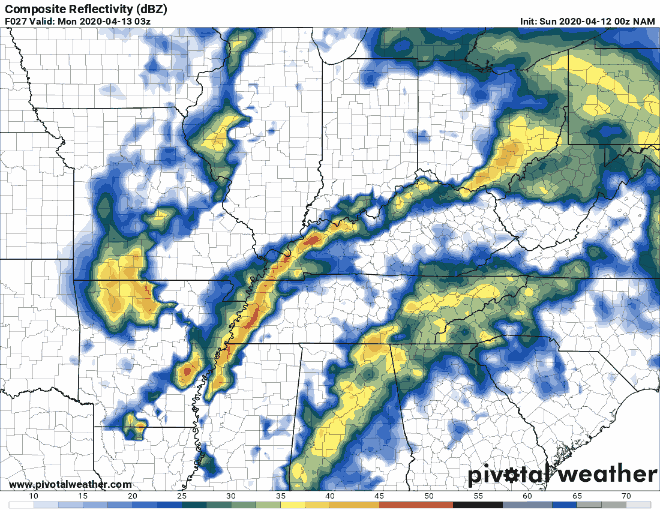
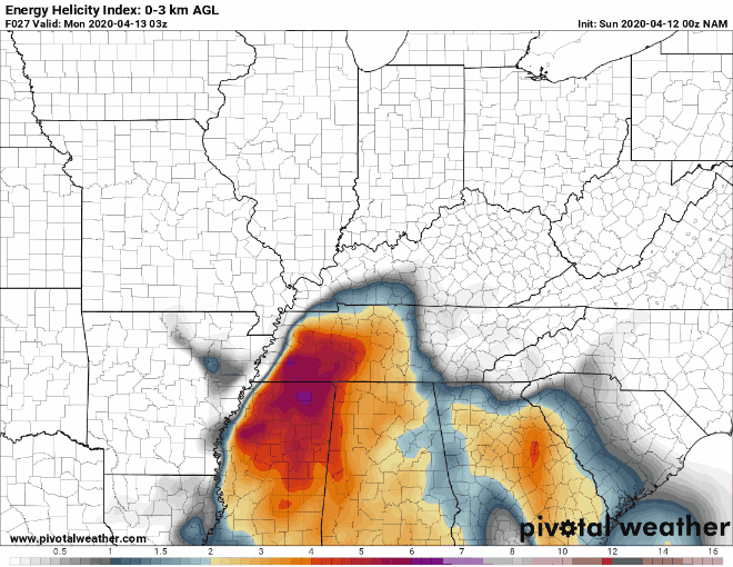
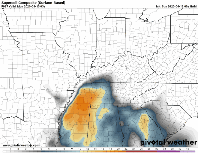
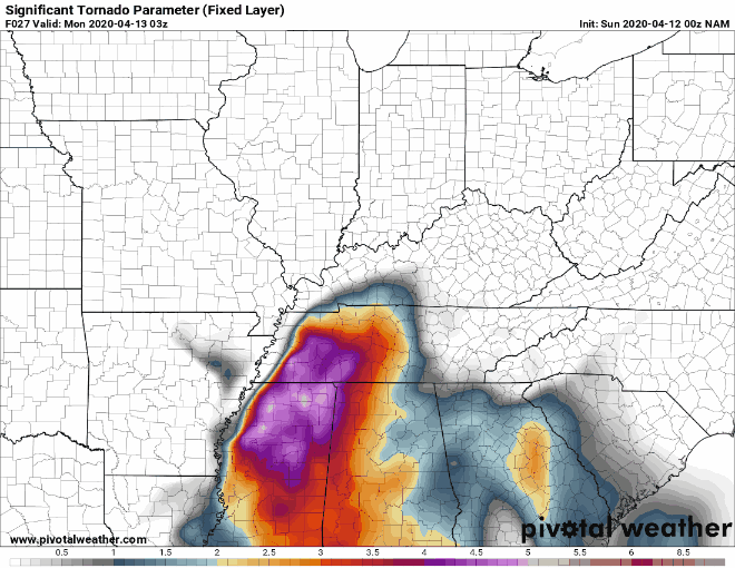
Since it appears that this severe weather event will be late Sunday evening into the early morning hours on Monday I'm issuing a BGP Severe Weather Alert. The Storm Prediction Center has moved the Enhanced Risk Area back westward but moved it more northward. The rest of Kentucky is covered by a Slight Risk Area except for portions of eastern Kentucky that portion is covered by a Marginal Risk Area. An outbreak of severe storms is expected today across portions of the Lower Mississippi Valley in the southeastern U.S. Intense storms capable of widespread damaging winds, large hail, and several strong tornadoes are possible with several rounds of storms from late morning into the overnight hours. As of this morning, these storms are not expected to reach western Kentucky until late Sunday evening then traverses in a northeasterly direction across the state. Conditions along a surface cold front will result in income upscale growth in one or more bowing segments. This could result in a corridor of intense damaging winds in western Kentucky during the evening/overnight hours. In addition to the damaging wind potential, mesovortex tornadoes (similar to tornadoes that form in the eyewall of a hurricane) also will be possible. These could cause multiple simultaneous tornado warnings as the radar detects their rotation. Here are the simulations all cover the 11 pm EDT Sunday to 11 am EDT Monday morning. Radar EHI Possible supercell development Possible significant tornado development This is an evolving situation and I will update this afternoon.
-
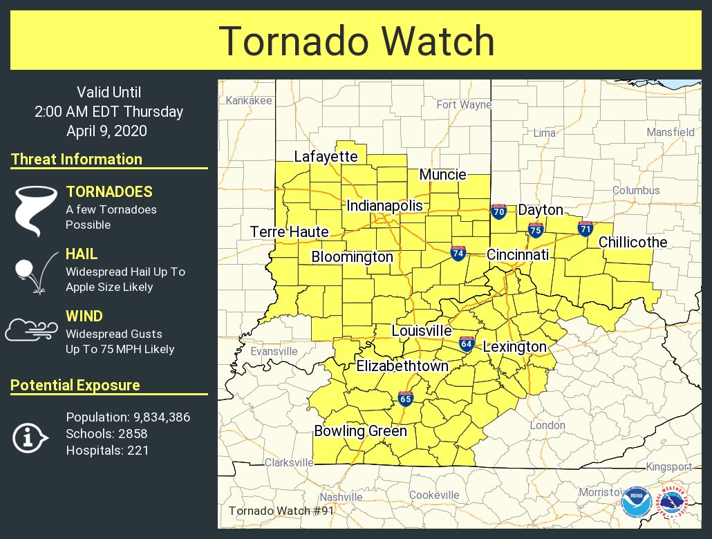
Tornado Watch Number 91 NWS Storm Prediction Center Norman OK 725 PM EDT Wed Apr 8 2020 The NWS Storm Prediction Center has issued a * Tornado Watch for portions of Central and Southern Indiana Central Kentucky Southwest Ohio * Effective this Wednesday night and Thursday morning from 725 PM until 200 AM EDT. * Primary threats include... A few tornadoes possible Widespread damaging winds and isolated significant gusts to 75 mph likely Widespread large hail and isolated very large hail events to 3 inches in diameter likely SUMMARY...A fast-moving line of severe thunderstorms currently over Illinois will move across the watch area this evening. Large hail and damaging winds will be possible with these storms. A few tornadoes will also be possible - especially across the southern half of the watch. The tornado watch area is approximately along and 90 statute miles east and west of a line from 10 miles northwest of Muncie IN to 55 miles east southeast of Bowling Green KY.
-
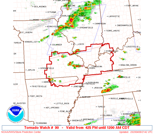
Tornado Watch Number 90 NWS Storm Prediction Center Norman OK 425 PM CDT Wed Apr 8 2020 The NWS Storm Prediction Center has issued a * Tornado Watch for portions of Northeast Arkansas Southern Illinois Southwest Indiana Western Kentucky Southeast Missouri * Effective this Wednesday afternoon from 425 PM until Midnight CDT. * Primary threats include... A couple of tornadoes possible Widespread large hail and isolated very large hail events to 3 inches in diameter likely Scattered damaging winds and isolated significant gusts to 75 mph likely SUMMARY...Thunderstorms will rapidly develop this afternoon across southeast Missouri and build eastward across the watch area this evening. Supercells and bowing segments capable of very large hail and damaging wind gusts are expected. A few tornadoes are possible. The tornado watch area is approximately along and 65 statute miles north and south of a line from 30 miles west-northwest of West Plains MO to 15 miles south southeast of Owensboro KY. PRECAUTIONARY/PREPAREDNESS ACTIONS... REMEMBER...A Tornado Watch means conditions are favorable for tornadoes and severe thunderstorms in and close to the watch area. Persons in these areas should be on the lookout for threatening weather conditions and listen for later statements and possible warnings.
-
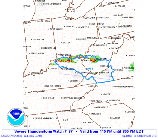
110 PM EDT Wed Apr 8 2020 The NWS Storm Prediction Center has issued a * Severe Thunderstorm Watch for portions of Northeast Kentucky Far southern Ohio Western Virginia Southern West Virginia * Effective this Wednesday afternoon and evening from 110 PM until 800 PM EDT. * Primary threats include... Scattered large hail events to 1.5 inches in diameter possible Isolated damaging wind gusts to 70 mph possible SUMMARY...Widely scattered strong to severe thunderstorms will continue to develop and move east-southeastward across the region this afternoon. Strong deep-layer shear and steep mid-level lapse rates will support some supercells and other organized clusters capable of severe hail and locally damaging winds. The severe thunderstorm watch area is approximately along and 50 statute miles north and south of a line from 30 miles north northwest of Lexington KY to 25 miles northeast of Dublin VA. For a complete depiction of the watch see the associated watch outline update (WOUS64 KWNS WOU7). PRECAUTIONARY/PREPAREDNESS ACTIONS... REMEMBER...A Severe Thunderstorm Watch means conditions are favorable for severe thunderstorms in and close to the watch area. Persons in these areas should be on the lookout for threatening weather conditions and listen for later statements and possible warnings. Severe thunderstorms can and occasionally do produce tornadoes.
-
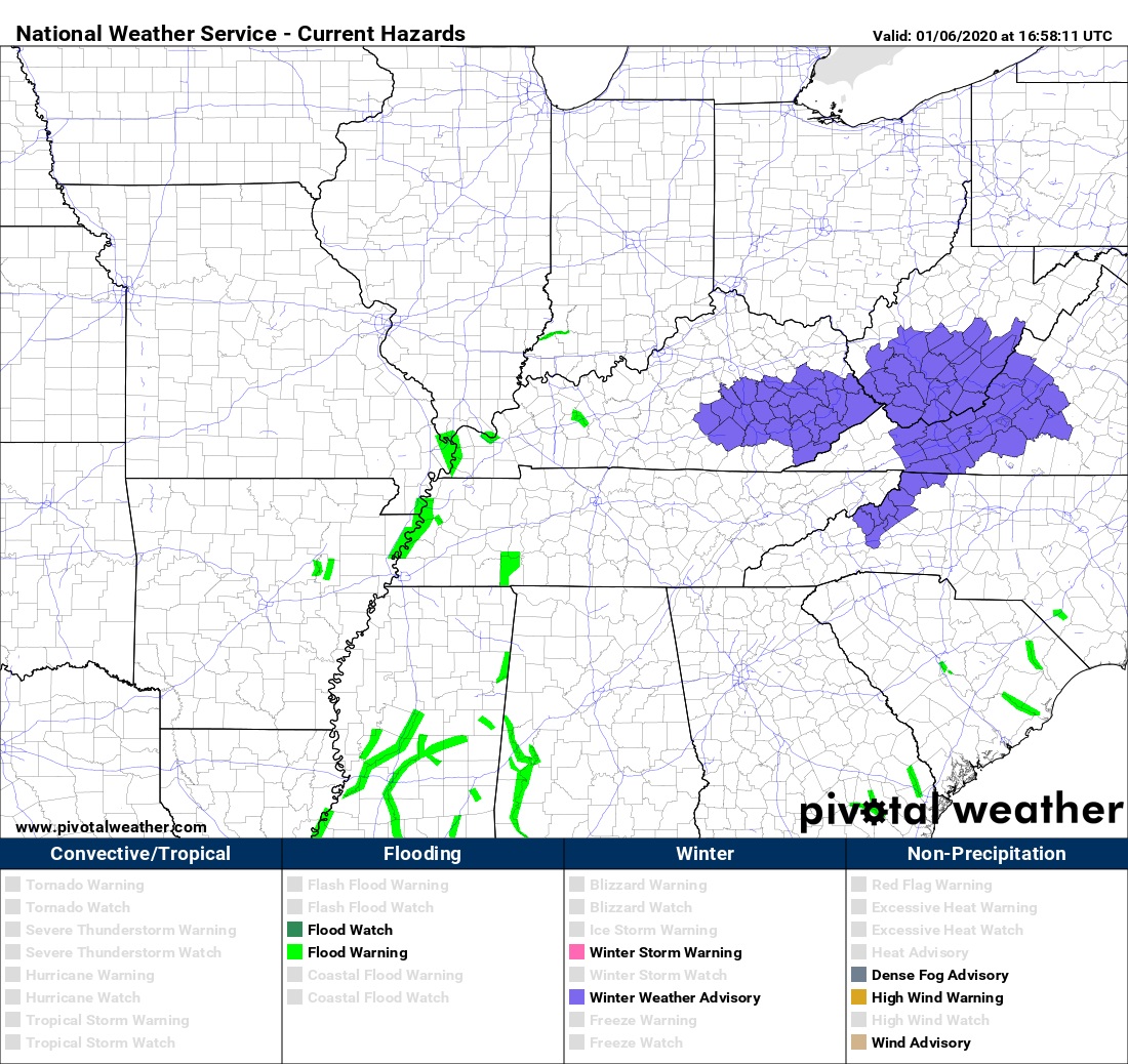
URGENT - WINTER WEATHER MESSAGE National Weather Service Louisville KY 1150 AM EST Mon Jan 6 2020 ...Light Snow Accumulations Tuesday Morning... KYZ056-057-066-067-070900- /O.NEW.KLMK.WW.Y.0001.200107T0700Z-200107T1300Z/ Garrard-Madison-Casey-Lincoln- Including the cities of Lancaster, Richmond, Liberty, and Stanford 1150 AM EST Mon Jan 6 2020 ...WINTER WEATHER ADVISORY IN EFFECT FROM 2 AM TO 8 AM EST TUESDAY... * WHAT...Rain will transition to snow early Tuesday morning. Total snow accumulations of up to one inch. * WHERE...Garrard, Madison, Casey and Lincoln Counties. * WHEN...From 2 AM to 8 AM EST Tuesday. * IMPACTS...Plan on slippery road conditions. The hazardous conditions could impact the morning commute. PRECAUTIONARY/PREPAREDNESS ACTIONS... Slow down and use caution while traveling. URGENT - WINTER WEATHER MESSAGE National Weather Service Jackson KY 1150 AM EST Mon Jan 6 2020 ...Quick Hitting Low Pressure System to Bring Snow to the Area Late Tonight and Tuesday Morning... .A fast developing area of low pressure will move through the Tennessee Valley and Southern Appalachians tonight into Tuesday. This will bring a rain changing to snow situation to much of eastern Kentucky after midnight with some quick snow accumulations possible. The roads and ground temperatures will be above freezing during the snow limiting accumulations, but a period or two of heavier snow should be able to overcome this and result in some small accumulations Tuesday morning. Most places will see around an inch of snow with some higher amounts possible on ridgetops. The best accumulations will be on elevated surfaces like wooden decks and railings along with grassy surfaces. Some slushy accumulations on the roads for a time Tuesday morning could result in slick conditions for the morning commute. Also, visibility could be significantly reduceD at times due to a small period of moderate to heavy snow fall rates. KYZ058-059-068-069-079-080-088-106>120-070415- /O.NEW.KJKL.WW.Y.0001.200107T0700Z-200107T1700Z/ Estill-Powell-Rockcastle-Jackson-Pulaski-Laurel-Harlan-Morgan- Johnson-Wolfe-Magoffin-Floyd-Lee-Breathitt-Knott-Owsley-Perry- Clay-Leslie-Letcher-Martin-Pike- Including the cities of Irvine, Ravenna, Clay City, Stanton, Brodhead, Mount Vernon, McKee, Annville, Burnside, Somerset, London, Cumberland, Harlan, West Liberty, Paintsville, Campton, Salyersville, Prestonsburg, Wheelwright, Beattyville, Jackson, Hindman, Pippa Passes, Booneville, Hazard, Manchester, Hyden, Jenkins, Whitesburg, Inez, Coal Run, Elkhorn City, Pikeville, and South Williamson 1150 AM EST Mon Jan 6 2020 ...WINTER WEATHER ADVISORY IN EFFECT FROM 2 AM TO NOON EST TUESDAY... * WHAT...Snow expected. Total snow accumulations of one to two inches. Most places will see around an inch. * WHERE...Portions of east central, northeast, south central and southeast Kentucky. * WHEN...From 2 AM to noon EST Tuesday. * IMPACTS...Plan on slippery road conditions. The hazardous conditions could impact the morning commute. PRECAUTIONARY/PREPAREDNESS ACTIONS... Slow down and use caution while traveling.
-
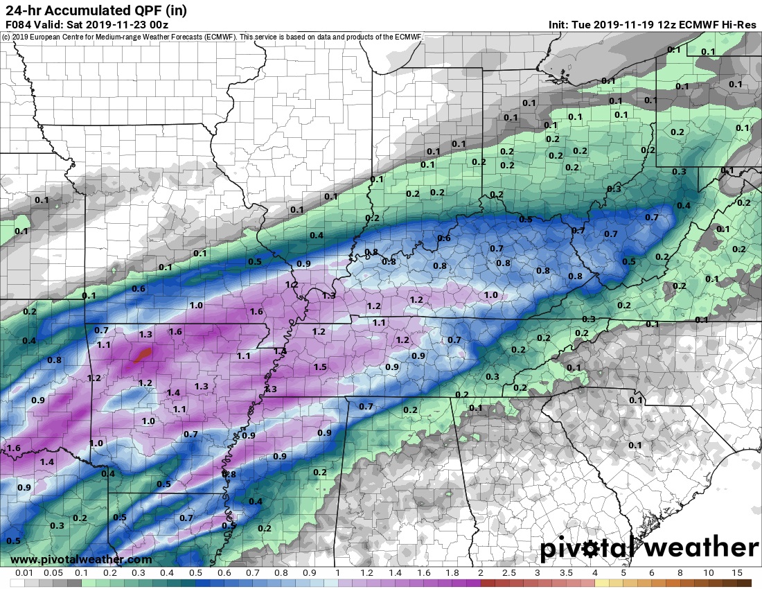
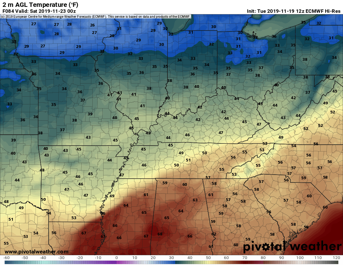
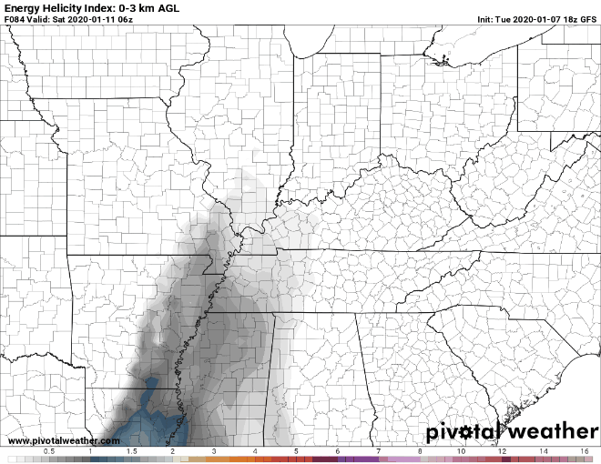
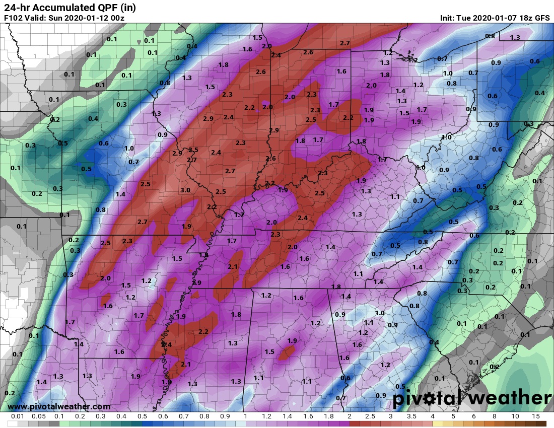
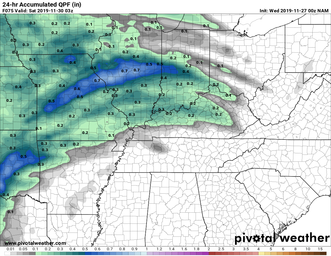
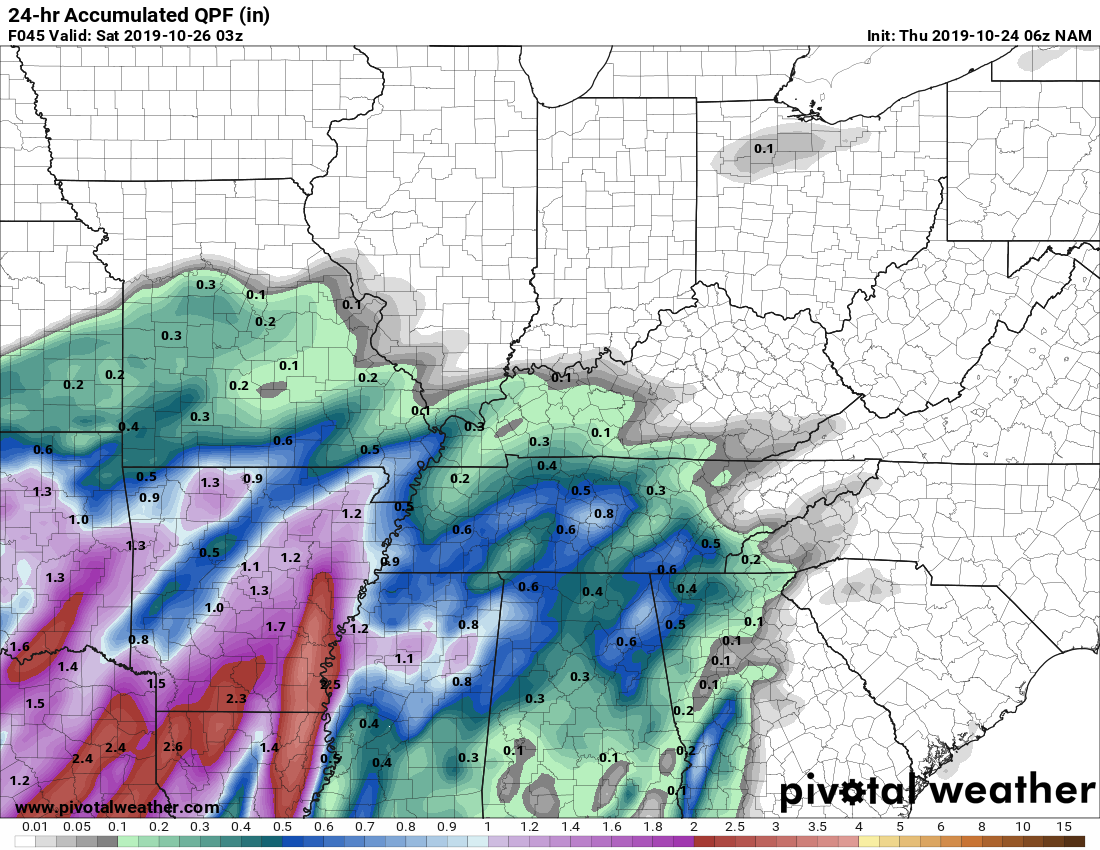
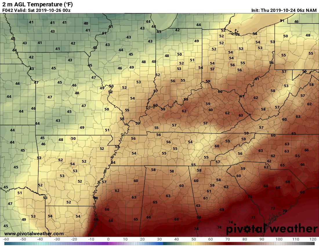
There is a possibility of some storms on Saturday. Afternoon temps could reach the low 70s for some. With this unseasonably warm weather comes the chances of strong to severe thunderstorms. First the temperature map. It shows the temps in the mid to high 60s for most of Kentucky. A low-pressure system is forecast to develop along a stationary front just to the west of Kentucky early Saturday morning. This stationary front will start to move across Kentucky during the day on Saturday and switch to a cold front. A line of storms will develop and traverse Kentucky in an easterly direction. The GFS EHI is showing conditions could be favorable for these storms to be strong to severe. Most of Kentucky could receive 1-2.5" of rain Saturday. I will be monitoring this situation and post updates as we get closer.
-
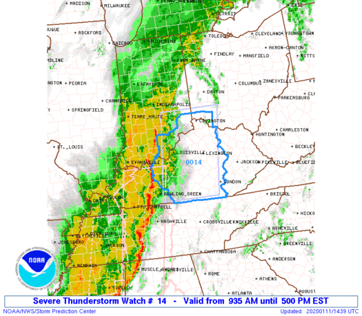
URGENT - IMMEDIATE BROADCAST REQUESTED Severe Thunderstorm Watch Number 14 NWS Storm Prediction Center Norman OK 935 AM EST Sat Jan 11 2020 The NWS Storm Prediction Center has issued a * Severe Thunderstorm Watch for portions of Southeast Indiana Central Kentucky Southwest Ohio * Effective this Saturday morning and afternoon from 935 AM until 500 PM EST. * Primary threats include... Scattered damaging wind gusts to 70 mph possible A tornado or two possible SUMMARY...A fast-moving line of thunderstorms will pose a risk of gusty/damaging winds through the day as it tracks across the watch area. An isolated/brief tornado or two is also possible. The severe thunderstorm watch area is approximately along and 60 statute miles east and west of a line from 35 miles northwest of Cincinnati OH to 100 miles south-southwest of Lexington KY. PRECAUTIONARY/PREPAREDNESS ACTIONS... REMEMBER...A Severe Thunderstorm Watch means conditions are favorable for severe thunderstorms in and close to the watch area. Persons in these areas should be on the lookout for threatening weather conditions and listen for later statements and possible warnings. Severe thunderstorms can and occasionally do produce tornadoes.
-
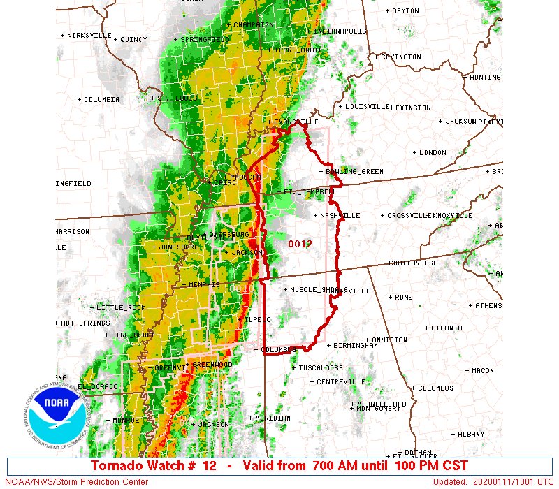
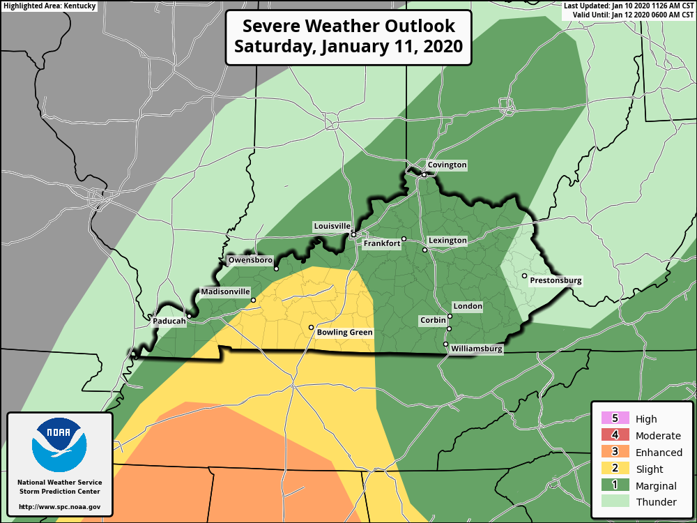
A Tornado Watch has just been issued for portions of Kentucky. TORNADO WATCH OUTLINE UPDATE FOR WT 12 NWS STORM PREDICTION CENTER NORMAN OK 700 AM CST SAT JAN 11 2020 TORNADO WATCH 12 IS IN EFFECT UNTIL 100 PM CST FOR THE FOLLOWING LOCATIONS KYC003-031-033-047-059-091-107-141-143-149-177-183-213-219-221- 227-111900- /O.NEW.KWNS.TO.A.0012.200111T1300Z-200111T1900Z/ KY . KENTUCKY COUNTIES INCLUDED ARE ALLEN BUTLER CALDWELL CHRISTIAN DAVIESS HANCOCK HOPKINS LOGAN LYON MCLEAN MUHLENBERG OHIO SIMPSON TODD TRIGG WARREN
-
A Category 2 Slight Risk Area now includes sections of Kentucky. The severe risk associated with the northern part of the squall line that is expected to develop Friday night into Saturday may produce damaging wind gusts along with a possible tornado or two.
-
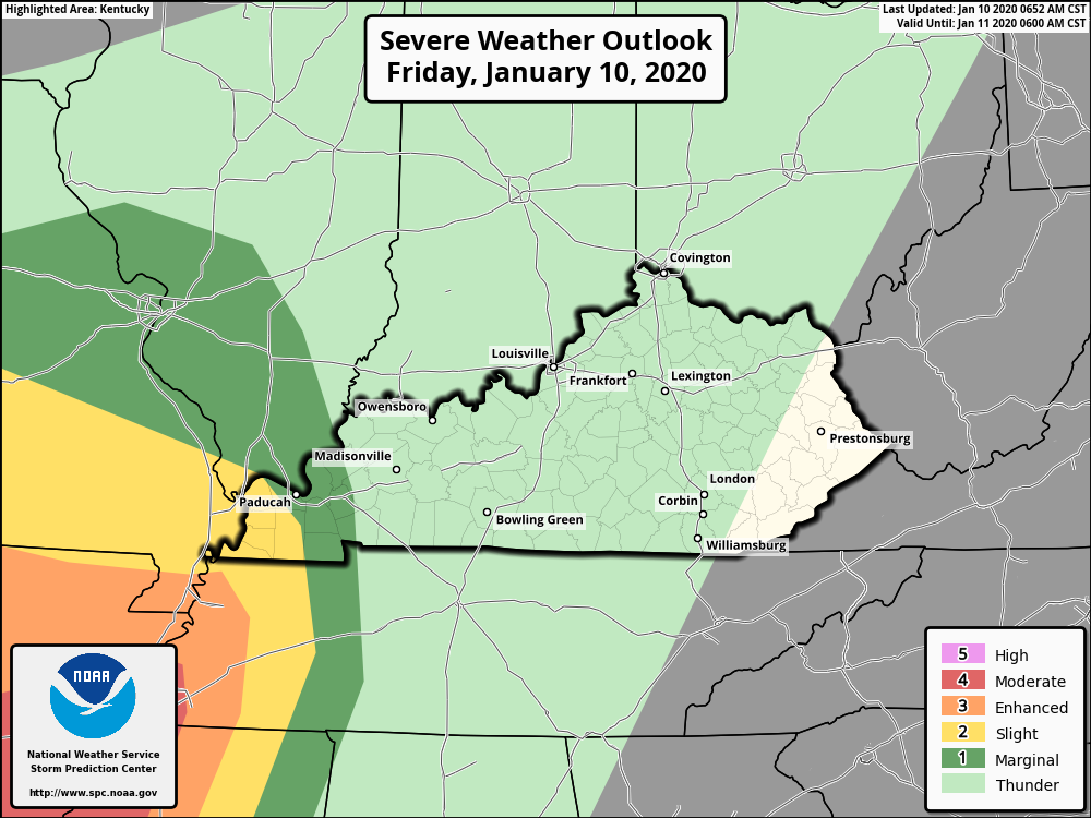
An outbreak of severe thunderstorms is possible later today through tonight, with the most dangerous portion being tonight into early Saturday morning with a potential derecho and embedded strong tornado risk.
-
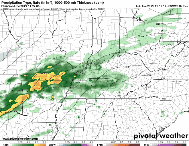
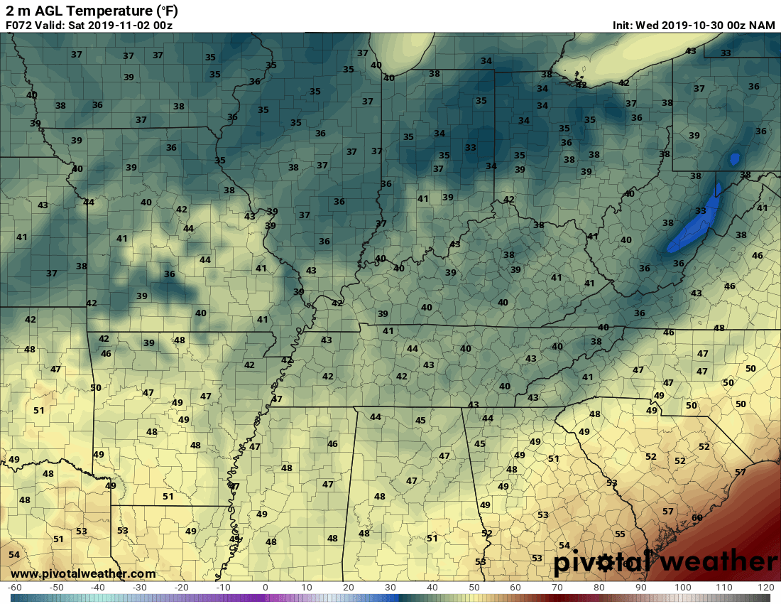
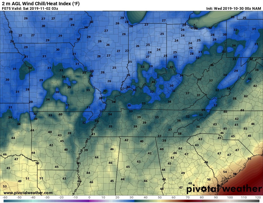
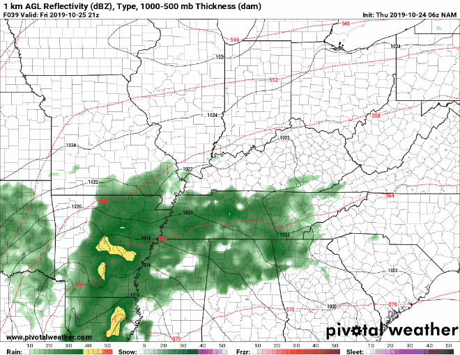
Rain is in the forecast for this Friday's games. The shower activity will be off and on all evening. Some may not even see any rain until after the games are over. The following maps are from 4 pm to 10 pm EST. The temperatures look to start off Friday evening in the low to mid-40s over parts of the state south of I-64. While north of I-64 they will range from the high 30s to low 40s. They will fall to the high 30s to low 40s for south of the I-64 corridor. North of that point look for temps to be in the mid-30s. Using the same dividing line as above look for the wind chills to fall to around the low to mid-30s south. Then north of I-64, they will be from the high 20s to low 30s by around 10 pm EST. The rain will be scattered and light for the most part. With light accumulations, until around 10 pm EST, the heaver showers look to move in late Friday night in Saturday morning and last for most of the weekend. Accumulation amounts will range from a trace to around 2 tenths of an inch. Just enough to make it uncomfortable for some. Check back for updates as we get closer to Friday.
-
.thumb.jpg.d475a671bdc851f901dea439c04b8f9d.jpg) The games on Thursday look to be on the wet side. Temperatures will range from the low 50s in southeast Kentucky to the high 30s to low 40s across the rest of the state. Those in NKY area could see some freezing rain/snow before the precipitation ends. For now up to an inch of snow accumulation maybe possible. The games on Friday look to be dry but cold. Temperatures could range anywhere from the mid-20s to low 30s at the start of the games. updates as we get closer to the game times.
The games on Thursday look to be on the wet side. Temperatures will range from the low 50s in southeast Kentucky to the high 30s to low 40s across the rest of the state. Those in NKY area could see some freezing rain/snow before the precipitation ends. For now up to an inch of snow accumulation maybe possible. The games on Friday look to be dry but cold. Temperatures could range anywhere from the mid-20s to low 30s at the start of the games. updates as we get closer to the game times.
-
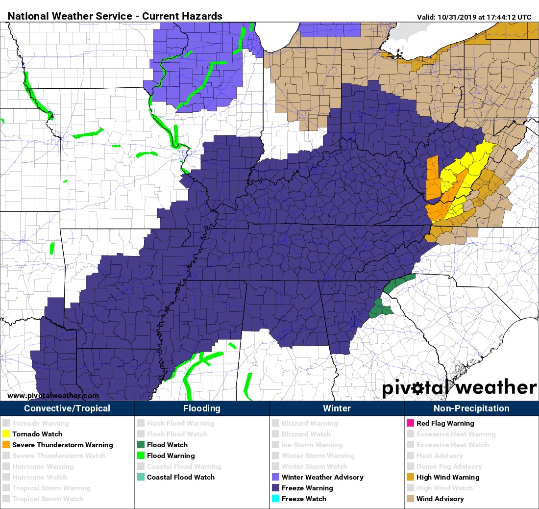
...FREEZE WARNING REMAINS IN EFFECT FROM 11 PM EDT /10 PM CDT/ THIS EVENING TO 11 AM EDT /10 AM CDT/ FRIDAY... ...DENSE FOG ADVISORY HAS EXPIRED... * WHAT...Lows in the mid to upper 20s. * WHERE...Portions of south central Indiana and all of central Kentucky. * WHEN...From late tonight through Friday morning. * Impacts...Freeze conditions will kill sensitive vegetation and possibly damage unprotected outdoor plumbing. * ADDITIONAL DETAILS...Winds will stay up enough before daybreak Friday to allow wind chills to bottom out around 20 degrees for most of the region. PRECAUTIONARY/PREPAREDNESS ACTIONS... Take steps now to protect tender plants from the cold. To prevent freezing and possible bursting of outdoor water pipes they should be wrapped, drained, or allowed to drip slowly. Those that have in-ground sprinkler systems should drain them and cover above- ground pipes to protect them from freezing. A Freeze Warning means sub-freezing temperatures are imminent or highly likely. These conditions will kill crops and other sensitive vegetation. For western Kentucky: 1056 AM CDT Thu Oct 31 2019 ...FREEZE WARNING REMAINS IN EFFECT FROM 10 PM THIS EVENING TO 10 AM CDT FRIDAY... * TEMPERATURE...Temperatures will fall below freezing by late this evening, with overnight lows in the middle to upper 20s. Readings will remain below freezing until mid-morning Friday. * IMPACTS...These temperatures will kill any unprotected vegetation, and this will likely end the growing season. PRECAUTIONARY/PREPAREDNESS ACTIONS... A Freeze Warning means sub-freezing temperatures are imminent or highly likely. These conditions will kill crops and other sensitive vegetation. For eastern Kentucky: ...FREEZE WARNING REMAINS IN EFFECT FROM 2 AM TO 10 AM EDT FRIDAY... * WHAT...Sub-freezing temperatures in the upper 20s. * WHERE...Portions of east central, south central and southeast Kentucky. * WHEN...From 2 AM to 10 AM EDT Friday. * IMPACTS...Frost and freeze conditions will kill crops and other sensitive vegetation. PRECAUTIONARY/PREPAREDNESS ACTIONS... Take steps now to protect tender plants from the cold. To prevent freezing and possible bursting of outdoor water pipes they should be wrapped, drained, or allowed to drip slowly. Those that have in-ground sprinkler systems should drain them and cover above- ground pipes to protect them from freezing.
-
Look for fall-like temperatures this upcoming Friday's games. They should range mainly from the mid to upper 30s to low 40s across the entire state of Kentucky. Temperatures should fall to the mid to upper 30s around 11 pm EDT. Some could see wind chill index around the low 30s around 11 pm EDT also. For now, there is no chance of precipitation. Updates, as we get closer to Friday, will be posted.
-
weather Forecast for this week's games (10/17-18/2019)
nWo posted a topic in KY Football (High School)
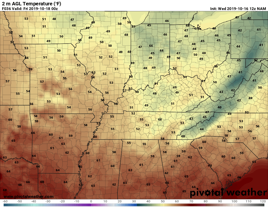
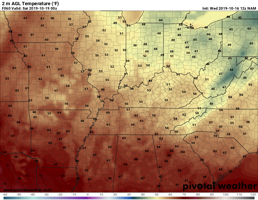
There is one game scheduled for Thursday. It will be a clash between North Laurel at Whitley County. Those attending this game can look for partly cloudy skies and temps in the low 50s around the start of the game. Temperatures should fall to the mid-40s around the time the game is over. For the games on Friday. The start of the game should see temps range from the low to mid-50s across most of Kentucky. Those in western Kentucky could see their temps from the mid to upper 50s. Some could even see temps in the low 60s. Temperatures should fall to the mid-40s to upper 40s around the end of the games around and north of I-64. Elsewhere temps should fall to the upper 40s to low 50s.
-
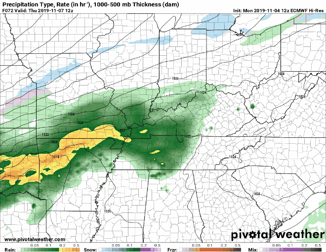
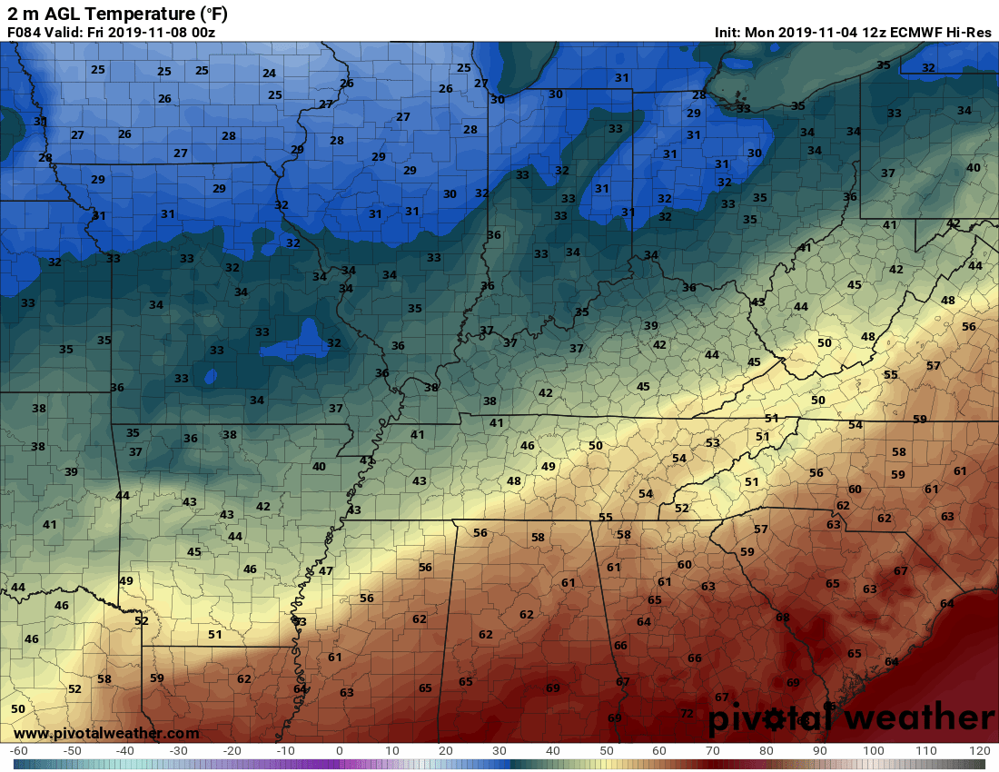
Here is the forecast for this Friday's games. Showers will start to enter Kentucky from the southwest early in the evening. The coverage will increase as the evening continues. Precipitation amounts will be mainly light at the onset of the rain. Heavier rain looks to move in late Friday into Saturday with upwards of around 1-inch accumulation possible by Saturday. Temperatures will range from the mid to upper 50s while some around the I-75 corridor could be in the low 60s.
-
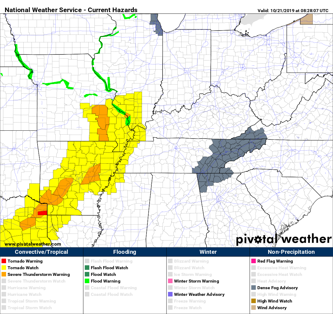
A Tornado Watch has just been issued for parts of western Kentucky. The watch is in effect until 9 am CDT for the following counties in western Kentucky. Ballard, Carlisle, Fulton, Graves, Hickman, and McCracken.
-
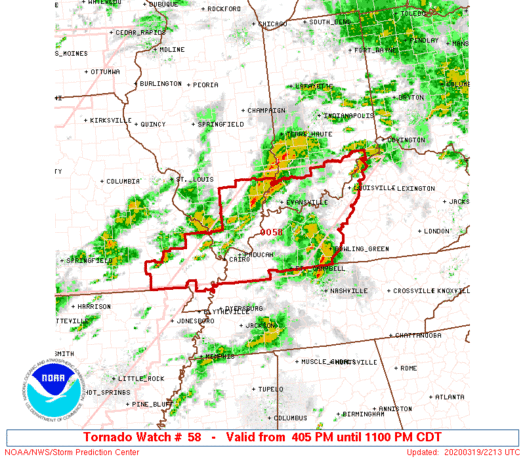
URGENT - IMMEDIATE BROADCAST REQUESTED Tornado Watch Number 58 NWS Storm Prediction Center Norman OK 405 PM CDT Thu Mar 19 2020 The NWS Storm Prediction Center has issued a * Tornado Watch for portions of southern Illinois southern Indiana western and central Kentucky southeast Missouri * Effective this Thursday afternoon and evening from 405 PM until 1100 PM CDT. * Primary threats include... A few tornadoes possible Scattered damaging wind gusts to 70 mph likely Isolated large hail events to 1.5 inches in diameter possible SUMMARY...Thunderstorms including a few supercells and bowing segments will continue developing and advancing eastward through the Ohio Valley this afternoon into the evening. Some of the storms will pose a threat for tornadoes, damaging wind and large hail. The tornado watch area is approximately along and 95 statute miles east and west of a line from 55 miles northwest of Louisville KY to 40 miles south southwest of Paducah KY. For a complete depiction of the watch see the associated watch outline update (WOUS64 KWNS WOU8). PRECAUTIONARY/PREPAREDNESS ACTIONS... REMEMBER...A Tornado Watch means conditions are favorable for tornadoes and severe thunderstorms in and close to the watch area. Persons in these areas should be on the lookout for threatening weather conditions and listen for later statements and possible warnings.
-
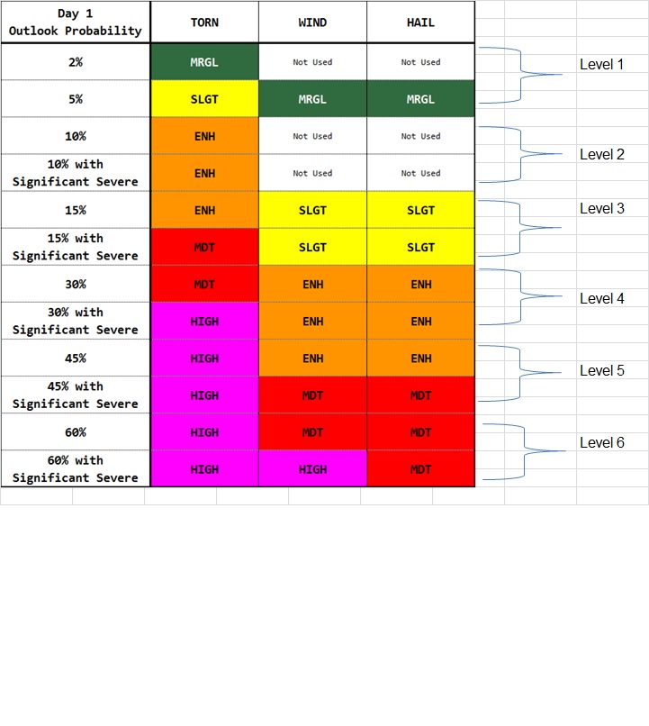
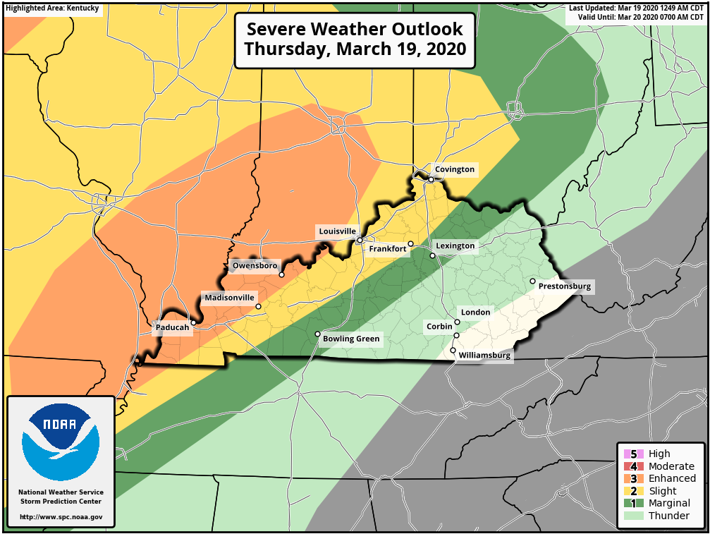
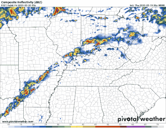
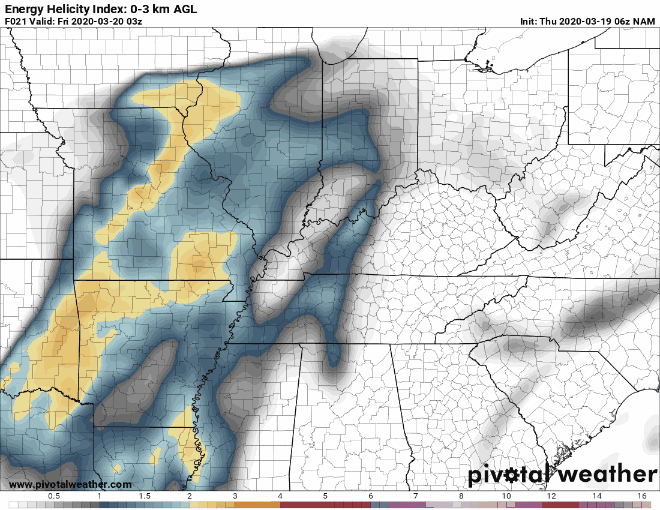
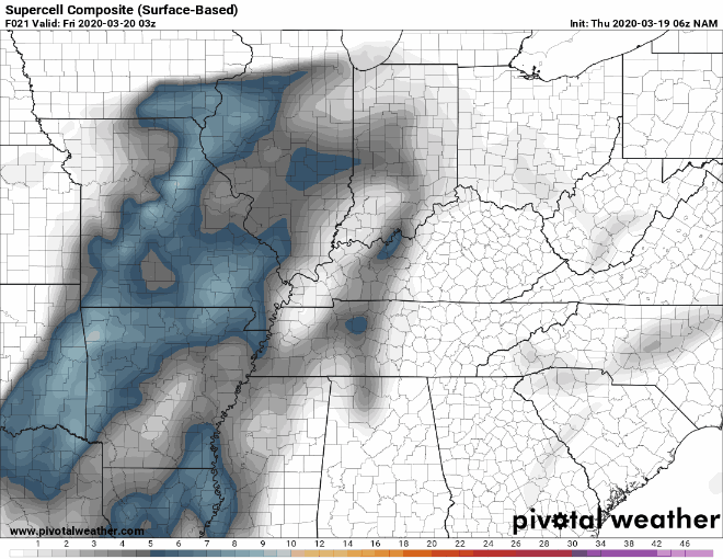
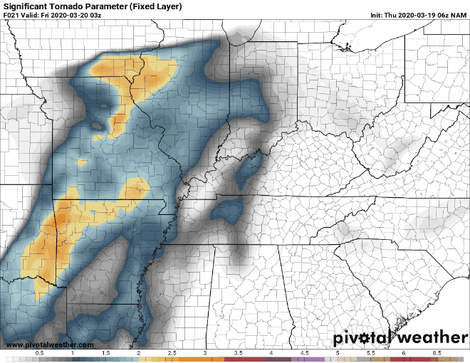
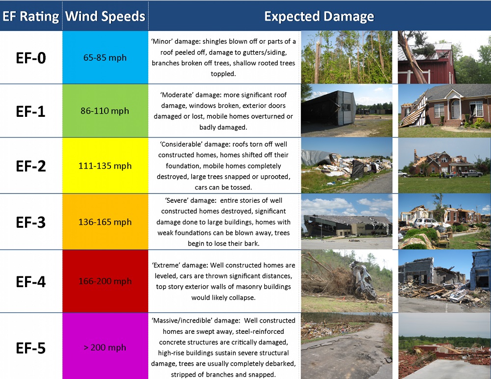
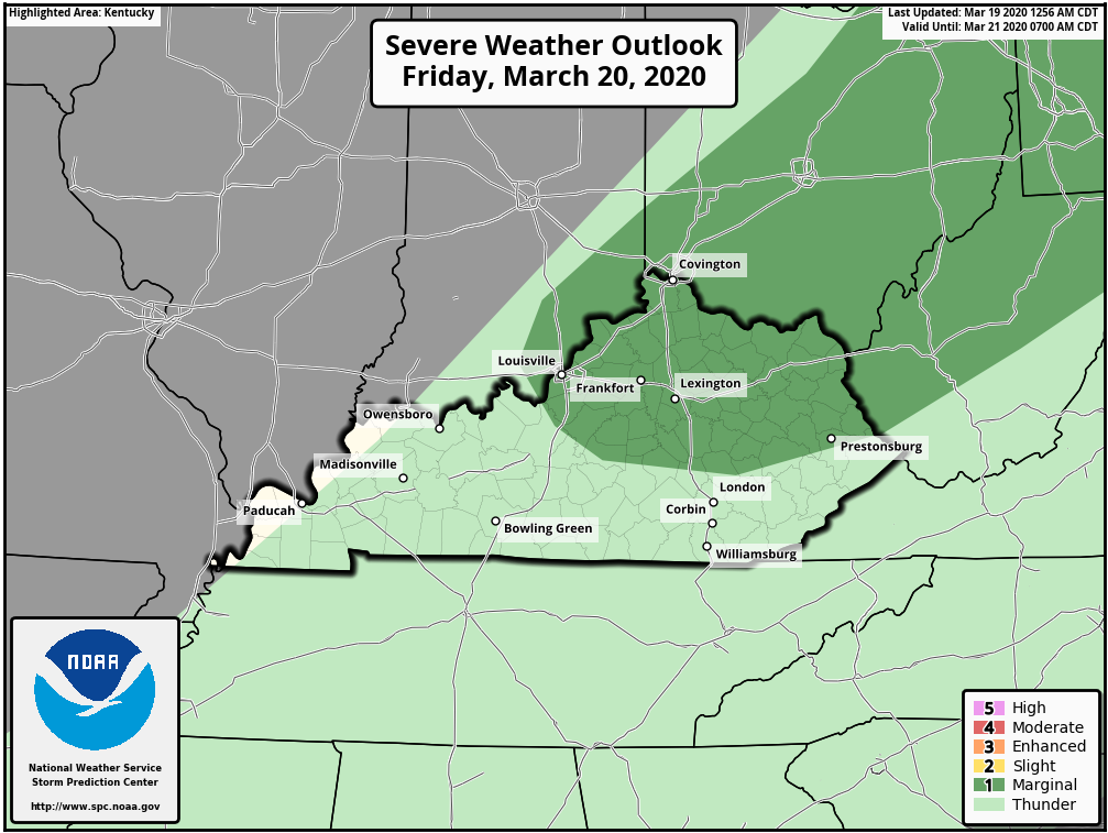
I"m issuing a BGP Severe Weather Alert Day for this evening into Friday morning. I'm also issuing a Level 2 BGP Tornado Threat Index. It will be on the high end of the Level 2 for portions of extreme western Kentucky. Severe Thunderstorms are expected for portions of the lower Ohio Valley. Damaging wind gusts, isolated large hail, and tornadoes are possible. It appears upper 60s surface dew points will exist in western Kentucky. While forecast lapse rate (the rate at which air temperature falls with increasing altitude) will not be steep, very strong shear and high moisture content in the upper atmosphere should prove sufficient for damaging wind and a tornado threat with organized line segments and embedded supercells. Given the conditions that should exist later this evening sections of western Kentucky are in a Category 3 Enhanced Risk area. Just east of that area a portion of Kentucky is in a Category 2 Slight Risk Area. Also, a narrow section of the state is in a Category 1 Marginal Risk Area. As of this morning, it appears that these storms won't reach western Kentucky until later tonight and move northeastward through Kentucky during the night into the early morning hours on Friday. The following is the HRRR radar. I'm using it because it shows the movement of the storms every hour. The NAM shows the position of the storms every 3 hours. The time period for all of the simulations is from 11 pm EDT Thursday to 8 am EDT Friday morning. HRRR Radar NAM EHI NAM Supercell NAM Significant Tornado The SARS-Soundings are indicating the strongest storms/supercells could produce hail 1" in diameter. Tornadoes from EF-0 to the low-end EF-3 category will also be possible. Everyone who could be affected should have a way to get notifications of impending severe weather in their area. Since this appears to be a late-night event please check the conditions in your area before going to be tonight. There is also a Category 1 Marginal Risk Area for Friday.